
Puget Boulevard is a curious street, for a number of reasons:
- The paved portions are only a few blocks long — hardly comparable to, say, Lake Washington Boulevard or Magnolia Boulevard;
- Both east–west and north–south portions are called Puget Boulevard SW, contrary to the rule that directional designations precede street names for east–west streets (this is why Lake Washington Boulevard E becomes E Lake Washington Boulevard when it curves west on its approach to Montlake Boulevard E);
- Despite its name, it has no view of Puget Sound, sitting as it does in the Longfellow Creek valley in the Delridge neighborhood of West Seattle;
- And, as it turns out, it isn’t even named for Puget Sound, as might be expected, but rather for the Puget Mill Company (later part of Pope & Talbot and today part of Rayonier).
The Puget Mill Company, which once owned large swaths of land in the city (including what became the Washington Park Arboretum and the Broadmoor Golf Club), made two donations to the city in 1912, according to the Ninth Annual Report of the Board of Park Commissioners:
- “A rugged tract of logged-off land south of Pigeon Point and Youngstown in the large unplatted area” (20.5 acres — this became Puget Park); and
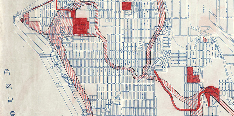
- “A strip of land 160 feet in width extending from Sixteenth Avenue Southwest and Edmonds Street (sic) to Thirty-fifth Avenue Southwest and Genessee Street, a distance of 8,500 feet, and comprising an area of about fifteen acres for parkway purposes. Under the conditions of this gift improvement work must be undertaken within five years. This acquisition forms an important link in the contemplated boulevard to West Seattle.”
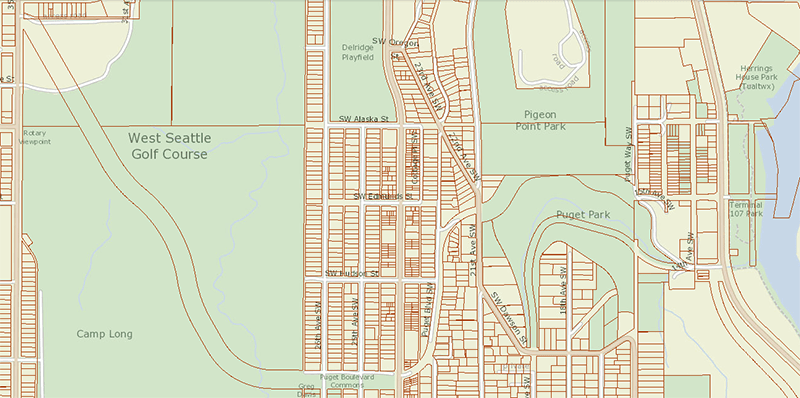
This strip is today’s Puget Boulevard SW. Two things become apparent when looking at the King County Parcel Viewer map of West Seattle:
- Almost the entire right-of-way still exists;
- But less than ½ a mile of it is improved; most of it runs through Puget Park, the West Seattle Golf Course, and West Seattle Stadium.

Once past the present site of West Seattle Stadium, the “contemplated boulevard to West Seattle” was to have run, as the Friends of Seattle’s Olmsted Parks puts it,
[Across] California Avenue a few blocks north of [the] present-day Alaska Junction, at that time part of the “Boston Subdivision.” It would have then headed northwest and down a ravine, eventually turning southwest to terminate at Alki Point.
Returning to the question of the name — the Puget Mill Company was, of course, named after Puget Sound, which itself was named in 1792 by Captain George Vancouver of HMS Discovery for Lieutenant Peter Puget (1765–1822).
Today, the paved portion of Puget Boulevard SW begins at 23rd Avenue SW, about 1⁄10 of a mile north of SW Hudson Street, and goes ⅕ of a mile south to a dead end. After a very short section — not more than 150 feet long — east of Delridge Way SW, which serves as a driveway for a complex of townhouses, it resumes west of a foot path off Delridge and goes about 1⁄10 of a mile west to 26th Avenue SW. Along this stretch, there are houses to the north and the Delridge P-Patch and Puget Boulevard Commons to the south.


Born and raised in Seattle, Benjamin Donguk Lukoff had his interest in local history kindled at the age of six, when his father bought him settler granddaughter Sophie Frye Bass’s Pig-Tail Days in Old Seattle at the gift shop of the Museum of History and Industry. He studied English, Russian, and linguistics at the University of Washington, and went on to earn his master’s in English linguistics from University College London. His book of rephotography, Seattle Then and Now, was published in 2010. An updated version came out in 2015.