NE NOAA Drive begins at Sand Point Way NE between NE 77th Street and the Fairway Estates access road and goes ¼ mile east to the beginning of a mile-long loop through the NOAA campus.
Born and raised in Seattle, Benjamin Donguk Lukoff had his interest in local history kindled at the age of six, when his father bought him settler granddaughter Sophie Frye Bass’s Pig-Tail Days in Old Seattle at the gift shop of the Museum of History and Industry. He studied English, Russian, and linguistics at the University of Washington, and went on to earn his master’s in English linguistics from University College London. His book of rephotography, Seattle Then and Now, was published in 2010. An updated version came out in 2015.
This pedestrianized stretch of 2nd Avenue N on the Seattle Center campus was renamed in 2018 after the Seattle Storm WNBA team, themselves so named “because of the weather here and what the team plans to do in the league.” Founded in 2000, their home court is Climate Pledge Arena, located between Seattle Storm Way and 1st Avenue N along Lenny Wilkens Way (formerly the 100 block of Thomas Street)
Before the 1962 Century 21 Exposition that brought Seattle the Space Needle and Monorail, 2nd Avenue N (earlier Poplar Avenue) continued north to Mercer Street and up Queen Anne Hill. The stretch between Thomas and Mercer Streets would remain a public right-of-way after its pedestrianization for nearly 30 years until it was vacated in 1991 at the request of Seattle Center “for the purpose of security and event control.”
Seattle Storm Way begins at Lenny Wilkens Way and goes a block north to the old Harrison Street right-of-way; the walkway between there and Mercer Street remains unnamed.
Born and raised in Seattle, Benjamin Donguk Lukoff had his interest in local history kindled at the age of six, when his father bought him settler granddaughter Sophie Frye Bass’s Pig-Tail Days in Old Seattle at the gift shop of the Museum of History and Industry. He studied English, Russian, and linguistics at the University of Washington, and went on to earn his master’s in English linguistics from University College London. His book of rephotography, Seattle Then and Now, was published in 2010. An updated version came out in 2015.
This street was created in 1907 as part of the plat of Magnolia Park, filed by the Magnolia Park Company. Insurance man Ferdinand Bosher Edgerly (1881–1966), president of the company, lived most of his life in Manchester, New Hampshire, but according to his obituary moved to Seattle after graduating from Dartmouth College in 1904, returning to Manchester in 1913. It would appear he named Dartmouth Avenue after his alma mater.
Dartmouth Avenue W begins at the end of W Howe Street, just east of Magnolia Way W, and goes just under 300 feet southwest to rejoin Magnolia Way W. Almost all of it, however, functions as private driveways for a number of houses with Magnolia Way addresses; the initial paved portion is less than 75 feet long and serves the only house with a Dartmouth Avenue address.
Born and raised in Seattle, Benjamin Donguk Lukoff had his interest in local history kindled at the age of six, when his father bought him settler granddaughter Sophie Frye Bass’s Pig-Tail Days in Old Seattle at the gift shop of the Museum of History and Industry. He studied English, Russian, and linguistics at the University of Washington, and went on to earn his master’s in English linguistics from University College London. His book of rephotography, Seattle Then and Now, was published in 2010. An updated version came out in 2015.
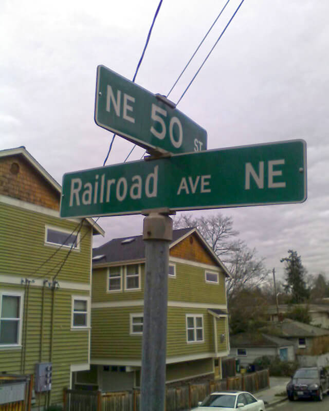
This street was created in 1946 by Ordinance 75507, “an ordinance accepting a deed from Eva M. Barquist, a spinster, to the City of Seattle for street purposes and laying off East 50th Street and Railroad Avenue Northeast.” This restored the Railroad Avenue NE name to a very short street on the east side of the Northern Pacific tracks, six years after it was changed to NE Blakely Street on the west side.
Railroad Avenue NE begins at NE 50th Street just east of 39th Avenue NE and goes 90 feet south to a dead end, essentially serving as a driveway for a cluster of townhouses.
Born and raised in Seattle, Benjamin Donguk Lukoff had his interest in local history kindled at the age of six, when his father bought him settler granddaughter Sophie Frye Bass’s Pig-Tail Days in Old Seattle at the gift shop of the Museum of History and Industry. He studied English, Russian, and linguistics at the University of Washington, and went on to earn his master’s in English linguistics from University College London. His book of rephotography, Seattle Then and Now, was published in 2010. An updated version came out in 2015.
Airport Way S does not, as one might expect, go from the city to Seattle–Tacoma International Airport (known to locals as Sea–Tac), but rather to King County International Airport (better known as Boeing Field). It got its current name in 1931 at the request of the Georgetown-South Seattle Improvement Club, which, according to an article in the April 12 issue of The Seattle Times,
…asked the City Council to merge portions of Seattle Boulevard, Eighth and Ninth Avenues South and Duwamish Avenue, leading from the central business area to Boeing Field, into a new highway, to be known as Airport Way.… [They contended] that strangers are confused in efforts to find the airport by lack of any specifically designated street leading to it.
The Beach or River Road… [which] skirted the shore of the bay at the foot of the high Beacon Hill bluff, east of what is now Airport Way, and ran south along the Duwamish.… Built in the early fifties, [it] was a hard road to keep in good condition.… In 1886, a road was built on piling over the mud flats a little west of the Beach Road to avoid the slides and floods. This street became known as the Grant Street Bridge.
Essentially, there were a series of roads following the semicircular curve of Elliott Bay from Downtown to the Duwamish River before the tideflats were filled in: first Beach Road (or River Road), then the Grant Street Bridge, which in turn became Seattle Boulevard once the fill was complete. Sometime before 1918… the portion of Seattle Boulevard that ran northeast–southwest (the southern third of the semicircle) was renamed Diagonal Avenue. (In 1931, the rest of Seattle Boulevard was renamed Airport Way.)
This photograph, taken circa 1900 by Anders Beer Wilse, looks northwest from Beacon Hill over the Grant Street Bridge and the Elliott Bay tideflats. At upper left is West Seattle; at upper right is Magnolia. From this perspective, Downtown Seattle appears just below Magnolia. Bainbridge Island is in the distance across Puget Sound.
Once Sea–Tac fully opened in 1949, Airport Way S no longer led to the region’s primary airport, which was more directly reached via U.S. 99, but no further name changes took place.
Today, Airport Way S begins at Seattle Boulevard S and 6th Avenue S and goes 6⅗ miles southeast, then south, then southeast again, ending at Boeing Access Road. Its lower 2½ miles parallel the eastern boundary of Boeing Field.
Born and raised in Seattle, Benjamin Donguk Lukoff had his interest in local history kindled at the age of six, when his father bought him settler granddaughter Sophie Frye Bass’s Pig-Tail Days in Old Seattle at the gift shop of the Museum of History and Industry. He studied English, Russian, and linguistics at the University of Washington, and went on to earn his master’s in English linguistics from University College London. His book of rephotography, Seattle Then and Now, was published in 2010. An updated version came out in 2015.
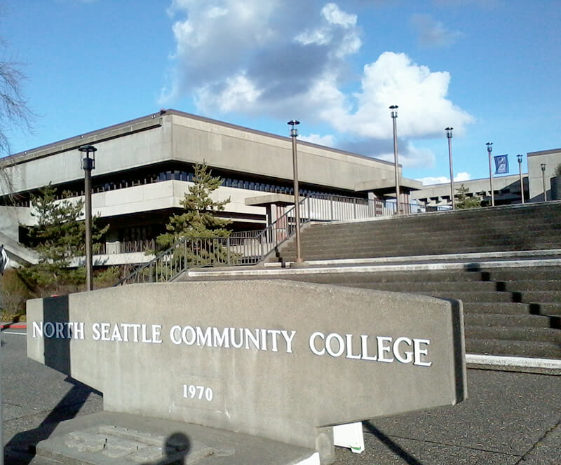
This street was named in 1971 as part of a project to connect Meridian Avenue N at N 103rd Street to Burke Avenue N at N 100th Street; the newly constructed street took the name, as did Burke Avenue south to N 92nd Street. For its entire ½-mile length, College Way N is the western boundary of the campus of North Seattle College, known at its 1970 founding as North Seattle Community College.
Born and raised in Seattle, Benjamin Donguk Lukoff had his interest in local history kindled at the age of six, when his father bought him settler granddaughter Sophie Frye Bass’s Pig-Tail Days in Old Seattle at the gift shop of the Museum of History and Industry. He studied English, Russian, and linguistics at the University of Washington, and went on to earn his master’s in English linguistics from University College London. His book of rephotography, Seattle Then and Now, was published in 2010. An updated version came out in 2015.
William Mortimer Lucas… was born in Illinois. Between 1908 and 1913 he was a speculative builder of houses in Seattle’s north end, houses that were financed by the sale of stock.… His office was located in the White Building in downtown Seattle. By 1912, the company was also selling plans for bungalows.
N Lucas Place begins at Stone Way N between N 40th Street and N 41st Street and goes about 375 feet east to Interlake Avenue N.
Born and raised in Seattle, Benjamin Donguk Lukoff had his interest in local history kindled at the age of six, when his father bought him settler granddaughter Sophie Frye Bass’s Pig-Tail Days in Old Seattle at the gift shop of the Museum of History and Industry. He studied English, Russian, and linguistics at the University of Washington, and went on to earn his master’s in English linguistics from University College London. His book of rephotography, Seattle Then and Now, was published in 2010. An updated version came out in 2015.
This North Queen Anne street originates in the 1907 Mayfair Addition to the City of Seattle, filed by the Mayfair Land Company. Don Sherwood notes that “Mayfair is a fashionable district in London, east of Hyde Park,” which was named after the annual May Fair (1686–1764).
Advertisement for the Mayfair Addition in The Seattle Times, March 8, 1907
Mayfair Avenue N begins at Florentia Street between 2nd Avenue N and 3rd Avenue N and goes just over ¼ of a mile south to just past Mayfair Park, where it becomes a private road that goes around 600 feet east to Nob Hill Avenue N. The private section runs through land once owned by the Lorentz family (Lorentz Place N) — in fact, a few members still own houses there.
Born and raised in Seattle, Benjamin Donguk Lukoff had his interest in local history kindled at the age of six, when his father bought him settler granddaughter Sophie Frye Bass’s Pig-Tail Days in Old Seattle at the gift shop of the Museum of History and Industry. He studied English, Russian, and linguistics at the University of Washington, and went on to earn his master’s in English linguistics from University College London. His book of rephotography, Seattle Then and Now, was published in 2010. An updated version came out in 2015.
Two real estate firms, F.W. Keen Company and J.L. Grandey, Inc., organized most of the racial restrictive covenants for Queen Anne from 1928 to 1931… specifying that “No person or persons of Asiatic, African or Negro blood, lineage, or extraction shall be permitted to occupy a portion of said property, or any building thereon; except domestic servants may actually and in good faith be employed by white occupants of such premises.”
In addition to being president of F.W. Keen, George Morford was vice president of J.L. Grandey.
Which Keen was honored by Keen Way N — Gertrude Alice Keen Morford, Frederick Walter Keen, or the F.W. Keen Company — isn’t clear; if it was for George Morford’s wife, that would put Keen Way in the same category as Perkins Lane W and Thorndyke Avenue W.
Keen Way N begins at Aurora Avenue N between W Green Lake Drive N and Winona Avenue N and goes ⅕ of a mile northeast to N 76th Street.
Frederick Walter Keen, from his Seattle Times obituary, August 14, 1929. I was unable to locate a photograph of his daughter, Gertrude.
Born and raised in Seattle, Benjamin Donguk Lukoff had his interest in local history kindled at the age of six, when his father bought him settler granddaughter Sophie Frye Bass’s Pig-Tail Days in Old Seattle at the gift shop of the Museum of History and Industry. He studied English, Russian, and linguistics at the University of Washington, and went on to earn his master’s in English linguistics from University College London. His book of rephotography, Seattle Then and Now, was published in 2010. An updated version came out in 2015.
This street was named in 1968 for Northgate Station, which opened in 1950 as the Northgate Center shopping mall. According to HistoryLink.org, it was “the country’s first regional shopping center to be defined as a ‘mall’ (although there were at least three predecessor shopping centers).” Newspaper archives show that it became known early on as Northgate Mall, and that became its official name in 1974. As of this writing, the property is in the midst of a massive redevelopment project that began in 2019.
Prior to 1968, Northgate Way was known as (from west to east) N 105th Street, Mineral Springs Way N, N 110th Street, NE 110th Street, and Chelsea Place NE. Today, it begins at N 105th Street and Aurora Avenue N and goes 2⅕ miles east to NE 113th Street and Lake City Way NE.
Digging into the newspaper archives, The Seattle Times of February 22, 1948, published a big spread on the plans for the shopping center. The story quoted one of the developers, a local investor named Ben Ehrlichman (the uncle of future Watergate figure John Ehrlichman). “The name Northgate was chosen, Ehrlichman [told The Seattle Times], because the development ‘will be the most important northerly business district serving Seattle and vicinity and the gateway to metropolitan Seattle.’” Though a 30th anniversary story in the same paper in 1980 credited Ehrlichman for coming up with the name — based on the 1948 story — we may never know for certain whose idea it was.
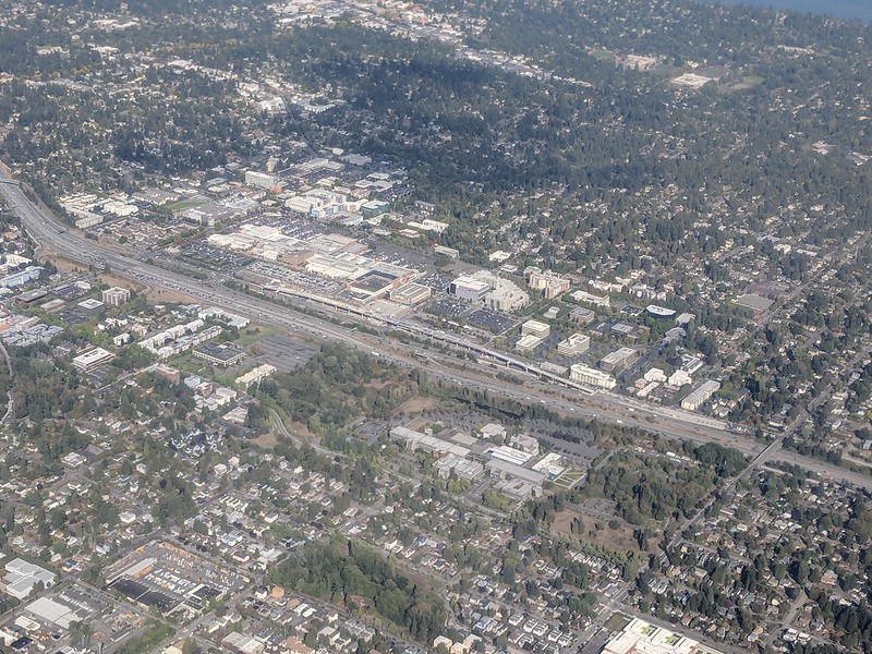
Aerial of Northgate, September 2018, looking northeast. Interstate 5 cuts across the photo from bottom right to upper left. To its west is North Seattle College; to its east is Northgate Station, the Thornton Place complex, the Northgate Transit Center, and the Northgate commercial district. The elevated tracks of Sound Transit’s Line 1 light rail can be seen just east of the freeway. The Lake City commercial district is visible to the northeast of the mall; the greenbelt closer to the mall is one of the forks of Thornton Creek. Photograph by Flickr user Atomic Taco, licensed under Creative Commons Attribution-ShareAlike 2.0 Generic
Born and raised in Seattle, Benjamin Donguk Lukoff had his interest in local history kindled at the age of six, when his father bought him settler granddaughter Sophie Frye Bass’s Pig-Tail Days in Old Seattle at the gift shop of the Museum of History and Industry. He studied English, Russian, and linguistics at the University of Washington, and went on to earn his master’s in English linguistics from University College London. His book of rephotography, Seattle Then and Now, was published in 2010. An updated version came out in 2015.
According to the Mount Baker Historic Context Statement, “Since Mount Baker Park was designed to be an exclusive single-family residential community, one of the early concerns of the Mount Baker Park Improvement Club was related to social issues, and what became known as the ‘Restrictions Committee’”:
[This committee] was involved in enforcing the restrictions contained in the deeds regarding single family housing only and the restrictive covenants that prevented non-whites from purchasing property in the area. The club passed a resolution stating that the club was against using any lot for clubs, schools, boarding or lodging houses, churches, charitable or religious societies or orders or for any other purpose than strictly detached family residences.
Discrimination in Mount Baker continued for decades, though it did eventually become a became a “locus for pushback against racial injustice.” The Seattle Star headlines below illustrate both the discrimination and early examples of resistance:
The first article, ‘Hunter Tract lots are not for colored people,’ appeared on April 2, 1909. An excerpt:
The owners of the Hunter tract, a fashionable residence addition overlooking Lake Washington, don’t intend to permit any colored people to build homes on their property.… F.H. Stone and Susie B. Stone are colored.… Arrangements were made by the Stones to erect a dwelling upon [their] lot. According to the officers of the investment company, it was then that they first discovered that the Stones were colored people.… [They] contended that if the Stones were permitted to build their dwelling and to occupy it, values of surrounding property would be decreased and a pecuniary hardship would therefore be worked upon the owners of the Hunter tract.
The case went to trial before Judge John F. Main. ‘No color line is drawn in Seattle’ appeared on November 6, 1909, the day after he rendered his decision:
The incident of color or race cannot of itself annul the terms of a contract, and there is no Mason and Dixon’s line in the residence district of Seattle.… Judge Main held, in substance, that no negro, because of his color, is legally barred from acquiring property and holding the same in the most exclusive community or from residing next door to his white neighbor.
Meanwhile, another related case was working its way through the courts. ‘Negro given right to live in Mt. Baker’ read the headline on February 1, 1910:
David Cole, a well-to-do negro… bought [a lot] from the Hunter Tract company. The officials of the company did not know that he was a negro until he came to the office to get his deed. Daniel Jones, agent for the firm, tried to buy him off… Cole insisted on having his deed and Jones refused to give it to him. Cole took the case to court and Judge Frater this morning decided that Jones must give Cole the deed. Jones immediately gave notice of appeal. Jones contended that Cole’s presence in the tract would lower property values from 40 to 50 per cent but Judge Frater held that a contract is a contract.
Born and raised in Seattle, Benjamin Donguk Lukoff had his interest in local history kindled at the age of six, when his father bought him settler granddaughter Sophie Frye Bass’s Pig-Tail Days in Old Seattle at the gift shop of the Museum of History and Industry. He studied English, Russian, and linguistics at the University of Washington, and went on to earn his master’s in English linguistics from University College London. His book of rephotography, Seattle Then and Now, was published in 2010. An updated version came out in 2015.
Puget Boulevard is a curious street, for a number of reasons:
The paved portions are only a few blocks long — hardly comparable to, say, Lake Washington Boulevard or Magnolia Boulevard;
Both east–west and north–south portions are called Puget Boulevard SW, contrary to the rule that directional designations precede street names for east–west streets (this is why Lake Washington Boulevard E becomes E Lake Washington Boulevard when it curves west on its approach to Montlake Boulevard E);
Despite its name, it has no view of Puget Sound, sitting as it does in the Longfellow Creek valley in the Delridge neighborhood of West Seattle;
And, as it turns out, it isn’t even named for Puget Sound, as might be expected, but rather for the Puget Mill Company (later part of Pope & Talbot and today part of Rayonier).
“A rugged tract of logged-off land south of Pigeon Point and Youngstown in the large unplatted area” (20.5 acres — this became Puget Park); and
“A strip of land 160 feet in width extending from Sixteenth Avenue Southwest and Edmonds Street (sic) to Thirty-fifth Avenue Southwest and Genessee Street, a distance of 8,500 feet, and comprising an area of about fifteen acres for parkway purposes. Under the conditions of this gift improvement work must be undertaken within five years. This acquisition forms an important link in the contemplated boulevard to West Seattle.”
This strip is today’s Puget Boulevard SW. Two things become apparent when looking at the King County Parcel Viewer map of West Seattle:
Map of Puget Boulevard, from King County Parcel Viewer
Once past the present site of West Seattle Stadium, the “contemplated boulevard to West Seattle” was to have run, as the Friends of Seattle’s Olmsted Parks puts it,
[Across] California Avenue a few blocks north of [the] present-day Alaska Junction, at that time part of the “Boston Subdivision.” It would have then headed northwest and down a ravine, eventually turning southwest to terminate at Alki Point.
Map of proposed West Seattle Parkway, cropped from a 1928 map showing both existing (red) and proposed (red hatched) park features. Puget Park and Boulevard are at lower right. Courtesy of the Seattle Municipal Archives, Identifier 2333.
Returning to the question of the name — the Puget Mill Company was, of course, named after Puget Sound, which itself was named in 1792 by Captain George Vancouver of HMS Discovery for Lieutenant Peter Puget (1765–1822).
Today, the paved portion of Puget Boulevard SW begins at 23rd Avenue SW, about 1⁄10 of a mile north of SW Hudson Street, and goes ⅕ of a mile south to a dead end. After a very short section — not more than 150 feet long — east of Delridge Way SW, which serves as a driveway for a complex of townhouses, it resumes west of a foot path off Delridge and goes about 1⁄10 of a mile west to 26th Avenue SW. Along this stretch, there are houses to the north and the Delridge P-Patch and Puget Boulevard Commons to the south.
Born and raised in Seattle, Benjamin Donguk Lukoff had his interest in local history kindled at the age of six, when his father bought him settler granddaughter Sophie Frye Bass’s Pig-Tail Days in Old Seattle at the gift shop of the Museum of History and Industry. He studied English, Russian, and linguistics at the University of Washington, and went on to earn his master’s in English linguistics from University College London. His book of rephotography, Seattle Then and Now, was published in 2010. An updated version came out in 2015.
In the late 1850s, the federal government began construction on a road connecting Fort Steilacoom in Pierce County to Fort Bellingham in Whatcom County. By the end of the decade, the military road had been finished (just in time for Fort Bellingham to close). The route it took through Seattle included what are now Beacon Avenue S, 1st Avenue, Dexter Avenue N, Westlake Avenue N, and Fremont Avenue N, among other streets. South of Seattle, much of the road still exists with its original name, but within the city limits, only a bit of Military Road S remains:
A 750-foot-long stretch between Beacon Avenue S at 27th Avenue S and Van Asselt Elementary School south of S Myrtle Street
A ½-mile-long stretch between S Othello Street just south of the school to the Union Pacific railroad tracks east of Airport Way S, just west of Interstate 5
Born and raised in Seattle, Benjamin Donguk Lukoff had his interest in local history kindled at the age of six, when his father bought him settler granddaughter Sophie Frye Bass’s Pig-Tail Days in Old Seattle at the gift shop of the Museum of History and Industry. He studied English, Russian, and linguistics at the University of Washington, and went on to earn his master’s in English linguistics from University College London. His book of rephotography, Seattle Then and Now, was published in 2010. An updated version came out in 2015.
This street, originally named Columbian Way in the 1920 plat of Victory Heights, was given its current name sometime during or before 1936, the first time I find it mentioned in the archives of The Seattle Times. I presume this was to avoid confusion with the Columbian Way in South Seattle, even though Victory Heights wasn’t annexed to Seattle until 1953.
The plat was filed by the Goodwin Real Estate Company and the Squire Investment Company. The Goodwin Real Estate Company at that time had Ervin Shirley Goodwin (1869–1937) as its president and his nephew, Arthur Eliot Goodwin (1887–1960), as its secretary. (Ervin and his brothers were instrumental in the development of Pike Place Market.) I presume the renaming was to honor Erwin rather than Arthur, though explicit explanations are rarely given for street naming. It may very well have been to honor the company. (Incidentally, Erwin’s wife, Eda, was a founder of the Seattle Fruit and Flower Mission in 1907; this organization became the Seattle Milk Fund in 1935 and Goodwin Connections in 2019.)
Ervin Shirley Goodwin
Unfortunately, in addition to being major developers (in addition to Victory Heights, they were behind Lakeridge, Hawthorne Hills, and subdivisions in Northgate, Lake City, and Windermere), the Goodwin Real Estate Company were pioneers in imposing racial restrictive covenants on their developments. As the Seattle Civil Rights & Labor History Project writes,
Seattle’s first known racial restrictive covenant was written in 1924 by the Goodwin Company and applied to three tracts of land and one block of the company’s development in the Victory Heights neighborhood in north Seattle.
It read:
Said tract shall not be sold, leased, or rented to any person or persons other than of Caucasian race nor shall any person or persons other than of Caucasian race use or occupy said tract.
Goodwin Way NE begins at 19th Avenue NE just north of NE Northgate Way and goes ¼ mile northwest to 15th Avenue NE between NE 113th Street and NE 115th Street.
Born and raised in Seattle, Benjamin Donguk Lukoff had his interest in local history kindled at the age of six, when his father bought him settler granddaughter Sophie Frye Bass’s Pig-Tail Days in Old Seattle at the gift shop of the Museum of History and Industry. He studied English, Russian, and linguistics at the University of Washington, and went on to earn his master’s in English linguistics from University College London. His book of rephotography, Seattle Then and Now, was published in 2010. An updated version came out in 2015.
Today, W Republican Street begins a block west of 4th Avenue W and goes ⅖ of a mile east to Warren Avenue N, where it becomes Seattle Center’s pedestrian August Wilson Way. On the east side of Seattle Center, there is a one-block segment of Republican Street between 4th Avenue N and 5th Avenue N; the street then resumes at Dexter Avenue N at the northbound exit from the State Route 99 Tunnel. From there, it runs ⅔ of a mile east to Eastlake Avenue E, where it is blocked by Interstate 5. Resuming east of I-5 as a stairway at Melrose Avenue E, it becomes a street again after half a block and goes another 1⅕ miles from Bellevue Avenue E to 23rd Avenue E, interrupted only once at 17th Avenue E, which can only be crossed by pedestrians and bicycles. After a substantial gap, E Republican Street begins again at 29th Avenue E and E Arthur Place in Madison Valley, and goes ⅖ east to its end at Lake Washington Boulevard E.
(From 33rd Avenue E to Lake Washington Boulevard E, it forms the northern boundary of the Bush School campus; when I went there in the 1980s and 1990s, people from out of town thought I was joking when I told them I went to Bush School on Republican Street. The school, of course, wasn’t named for a member of the Bush political dynasty, but rather for its founder, Helen Taylor Bush.)
Born and raised in Seattle, Benjamin Donguk Lukoff had his interest in local history kindled at the age of six, when his father bought him settler granddaughter Sophie Frye Bass’s Pig-Tail Days in Old Seattle at the gift shop of the Museum of History and Industry. He studied English, Russian, and linguistics at the University of Washington, and went on to earn his master’s in English linguistics from University College London. His book of rephotography, Seattle Then and Now, was published in 2010. An updated version came out in 2015.
This winding, semicircular street runs almost ⁹⁄₁₀ of a mile from 15th Avenue NW and NW 100th Street in the east to Triton Drive NW, NW Neptune Place, and NW 100th Street in the west, descending 300 feet to Puget Sound along the way. Named after the Blue Ridge community, it was established in 1930 as part of the plat of Blue Ridge, an Addition to King County, Washington (rather than to Seattle, as the far northwestern section of the city wouldn’t be annexed until 1953).
No property in said Addition shall at any time be sold, conveyed, rented, or leased in whole or in part to any person or persons not of the White or Caucasian race. No person other than one of the White or Caucasian race shall be permitted to occupy any property in said addition or portion thereof or building thereon except a domestic servant actually employed by a person of the White or Caucasian race where the latter is an occupant of such property.
Uniquely, as they note, the restrictions on membership in the Blue Ridge Club, established in 1941 and forerunner of today’s homeowner association, were slightly different:
No Asiatic, Negro or any person born in the Turkish Empire, nor lineal descendant of such person shall be eligible for membership in the Club.
They speculate this restriction on Ottoman citizens and descendants thereof was aimed at Sephardic Jews (Seattle is said to have the third largest population in the country), although if that is the case, I wonder why the restriction wasn’t against all Jews, as was done in Broadmoor and the Sand Point Country Club. At any rate, it would seem to have affected not only Sephardim but Arabs, Levantines, and North Africans in general. These restrictions were finally lifted in 1989, decades after they became unenforceable.
Blue Ridge says that “The development of the Blue Ridge community and the government-engineered policies of segregation brings some controversy to the early days of the neighborhood. However, today Blue Ridge is diverse and welcoming to anyone wanting to share in all that it has to offer.” As the interactive map on the Seattle Civil Rights & Labor History Project page on Blue Ridge shows, though, the covenants had the desired effect — the neighborhood is still around 81% white, 12% Asian… and just 0.5% Black.
As far as being an “exclusive” neighborhood goes, Blue Ridge is more like Windermere than the above-mentioned Broadmoor and Sand Point Country Club; it features a private waterfront park, but all the streets are public, and there are even two very small public parks (Blue Ridge Circle and Blue Ridge Places) plus the wooded Mary Avenue Trail to the southern boundary of Carkeek Park.
Ten or so years ago I saw a Private Property sign at the trailhead, put up by the Blue Ridge Club, but it was gone the next time I visited — I can’t remember if I complained or someone else did. (The woods are private, but the trail is Mary Avenue NW right-of-way.) This wasn’t in the original plat, but according to an old Flickr chat I had with Andreas “Severinus” Breuer, “there was apparently a WPA project approved to install a 30′-wide gravel road between 100th and 110th (apparently now NW Carkeek Park Road).… I imagine the ravine would look quite different if a 30′ gravel road had been put in, so presumably this plan wasn’t carried out. But a 1940 engineering map shows a surveyed ROW from 105th to the Carkeek border, and in Carkeek there seems to be a route that follows the WPA route (Clay Pit Trail > Hillside Trail > Brick Road Trail > Road). Perhaps the trail that exists today was made by the original surveyors or by WPA men?”
Born and raised in Seattle, Benjamin Donguk Lukoff had his interest in local history kindled at the age of six, when his father bought him settler granddaughter Sophie Frye Bass’s Pig-Tail Days in Old Seattle at the gift shop of the Museum of History and Industry. He studied English, Russian, and linguistics at the University of Washington, and went on to earn his master’s in English linguistics from University College London. His book of rephotography, Seattle Then and Now, was published in 2010. An updated version came out in 2015.
This street runs just shy of a mile through the gated Broadmoor neighborhood and golf course from its south entrance at E Madison Street at 36th Avenue E to its north entrance at E Foster Island Road.
An article in the May 18, 1924, issue of The Seattle Times noted that “[Broadmoor’s] roadways will not be public streets as in other residential sections of the city,” calling this “one of the unmatched features of this community,” and adds that “certain restrictions have been named both as to the class of residences that may be constructed as well as to those who will be admitted to membership.” The entire community being private was a first for Seattle, and in fact has never been repeated — the Sand Point Country Club was also established in the late 1920s, but was in unincorporated King County at the time and wasn’t annexed until 1953, whereas Windermere, established within Seattle city limits around the same time, was in fact platted as a traditional neighborhood, albeit one with private amenities.
Speaking of those “certain restrictions,” by the way, it seems that even in the 1920s one could not say openly in the press what one really meant. But Broadmoor deeds and their racial restrictive covenants are public record:
No part of said property hereby conveyed shall ever be used or occupied by any Hebrew or by any person of the Ethiopian, Malay or any Asiatic Race, and the party of the second part, his heirs, personal representatives or assigns, shall never place any such person in the possession or occupancy of said property or any part thereof, nor permit the said property, or any part thereof, ever to be used or occupied by any such person, excepting only employees in the domestic service on the premises of persons qualified hereunder as occupants and users and residing on the premises.
Broadmoor: Restricted Residential Park With Golf Course, 1924. Courtesy of the Seattle Municipal Archives, Identifier 1423.
The origin of the Broadmoor name is not entirely clear. Did it have anything to do with the Broadmoor Golf Club in Colorado Springs, which opened in 1918? Or with the moors of Scotland, home of modern golf? The above-mentioned Seattle Times article, which is so similar to one in the Seattle Post-Intelligencer it must have been based on a Puget Mill Company press release, doesn’t say. (My friend, local historian Joe Mabel, notes the best-known Broadmoor in the U.K. is actually a high-security psychiatric hospital founded in 1863.) It may just be that “Broadmoor” was considered to be “elegant.” Perhaps the answer lies somewhere in the personal papers of Edwin Gardner Ames, Puget Mill president and one of the developers of Broadmoor along with Grosvenor Folsom and George W. Johnson.
Born and raised in Seattle, Benjamin Donguk Lukoff had his interest in local history kindled at the age of six, when his father bought him settler granddaughter Sophie Frye Bass’s Pig-Tail Days in Old Seattle at the gift shop of the Museum of History and Industry. He studied English, Russian, and linguistics at the University of Washington, and went on to earn his master’s in English linguistics from University College London. His book of rephotography, Seattle Then and Now, was published in 2010. An updated version came out in 2015.
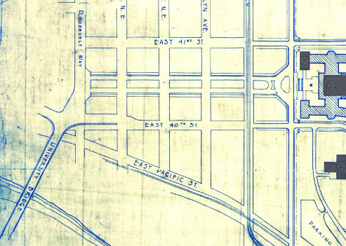
The Director of Highways is hereby authorized and directed to select and locate a suitable and fitting street and highway approach to the University of Washington campus in the City of Seattle, from Roosevelt Way to Fifteenth Avenue northeast, including an underpass beneath the surface of Roosevelt Way, and necessary approaches to said underpass.
(A separate section appears to have been responsible for the creation of Stadium Way in Pullman as an approach to Washington State University.) A Seattle ordinance passed the same year committed the city to build and maintain the road, as required by the law, and NE Campus Parkway opened in 1950 — HistoryLink refers to it as a “long-proposed ceremonial gateway to the University.” In 1954, the roadway was deeded to the city.
Portion of the Regents Plan showing planned route of Campus Parkway
In 1925 Bebb and Gould proposed a revision to their earlier Regents Plan of 1915, which included a formal boulevard that extended from the University to the west to serve as a principal entry to the campus from the city. Campus Parkway, the formal axis envisioned in the Regents Plan to the west, was constructed finally in the 1940s. It extended the University campus into its surrounding city neighborhood in a monumental and somewhat strident manner. Construction in the 1970s of an underground parking garage, below the Central Quadrangle [actually the Central Plaza, or Red Square], provided a primary vehicle entry south of Denny Hall, and reduced vehicular traffic along the campus ring road.
Traffic to and from lower campus and the lower University District via the University Bridge does necessarily take NE Campus Parkway, but it hardly functions as a gateway, ceremonial or otherwise. The entrance to the above-mentioned parking garage is at NE 41st Street, a block to the north; the west entrance to campus is a block to the south at NE 40th Street, which turns into W Stevens Way NE. One must take a narrow pedestrian bridge over 15th Avenue NE to walk from the parkway onto campus. The pedestrian-only southeast entrance at Rainier Vista and the north entrance at 17th Avenue NE, which turns into Memorial Way NE, fulfill the function far better.
Not even the UW Visitor Center is on NE Campus Parkway, having moved to Odegaard Library a number of years ago. Schmitz Hall, one of the university’s main administrative buildings, remains, between University Way NE and 15th Avenue NE, and with it the Office of Undergraduate Admissions and the Office of the University Registrar — and the university’s “mapping/directions address,” 1410 NE Campus Parkway.
(An aside — NE Campus Parkway was once home to the International Friendship Grove of Trees [see articles by Arthur Lee Jacobson and Dick Falkenbury] but many of the trees have since died or been removed.)
Born and raised in Seattle, Benjamin Donguk Lukoff had his interest in local history kindled at the age of six, when his father bought him settler granddaughter Sophie Frye Bass’s Pig-Tail Days in Old Seattle at the gift shop of the Museum of History and Industry. He studied English, Russian, and linguistics at the University of Washington, and went on to earn his master’s in English linguistics from University College London. His book of rephotography, Seattle Then and Now, was published in 2010. An updated version came out in 2015.
The neighborhood of Lawtonwood, or Lawton Wood — both spellings have been in use over the years — is perched atop Discovery Park north of W Cramer Street. Lawtonwood Road, which goes through the park, is the only way in or out. It would have been a natural part of Fort Lawton, and it certainly would have made a great addition to the park, but as local historian Paul Dorpat explains in his introduction to the neighborhood,
Steady white settlement started in 1875 when German immigrant Christian Scheuerman moved to the area, cleared the timber and married a native woman who had ten children before she died in 1884. In 1895 Seattle boosters organized to attract a military post to the area and gathered the acreage that is now Fort Lawton–Discovery Park. The part of it that is now Lawton Wood… is not part of the military holding because Scheuerman withheld it.
It should not be thought that Scheuerman cared nothing at all for the defense of Seattle — he and his family did donate 26.13 acres to the cause — though that made up less than 4% of the 704.21 acres given in total. (The single largest contributors of land were Thomas W. Prosch and his wife, Virginia, who gave 330.97 acres, a full 47%.)
Dorpat continues:
Soon after the military moved in next door, this protected enclave was improved with mansions of a few of Seattle’s elite. In 1952 these neighbors — about 30 houses sparingly distributed about a generous 30 acres – organized the Lawton Wood Improvement Club, waving the motto “To Beautify and Develop Lawton Wood.” By the time that the last of the Scheuermans, Ruby, moved out in the late 1970s, the beautifying had turned more to developing, and the lots got smaller.
The first reference to Lawtonwood Road I was able to find in The Seattle Times or the Seattle Post-Intelligencer is from 1935, but it does not appear to have been officially so designated until 2007. According to ordinance 122503, park roads “are considered ‘private’” — technically residents of Lawtonwood and Bay Terrace had no legal right to transit the park to reach their homes, though of course they had never been prevented from doing so. To rectify this and other issues, and in anticipation of the privatization of the residences on Officers’ Row and Montana Circle, the ordinance made Lawtonwood Road, Bay Terrace Road, Utah Street, Washington Avenue, California Avenue, Iowa Street, Illinois Avenue, Texas Way, Idaho Avenue, and 45th Avenue W “public park boulevards.”
Note, by the way, that none of these streets except 45th Avenue W contain a directional designation. Ordinarily one would expect to see W Lawtonwood Road, or Lawtonwood Road W, but park roads in Seattle carry no directional designation. An exception seems to have been made for 45th Avenue W, presumably because a numbered avenue with no directional designation “belongs” in Madrona or Leschi, seven miles to the southeast.
Born and raised in Seattle, Benjamin Donguk Lukoff had his interest in local history kindled at the age of six, when his father bought him settler granddaughter Sophie Frye Bass’s Pig-Tail Days in Old Seattle at the gift shop of the Museum of History and Industry. He studied English, Russian, and linguistics at the University of Washington, and went on to earn his master’s in English linguistics from University College London. His book of rephotography, Seattle Then and Now, was published in 2010. An updated version came out in 2015.
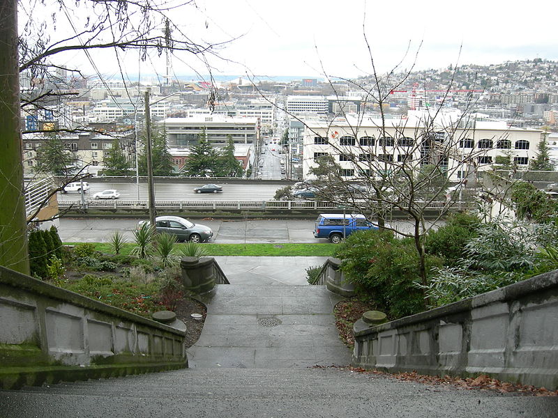
The bulk of W Lawton Street comes not from the Lawton Park plat, which covered 34th Avenue W to 36th Avenue W, but from a grant from the federal government in 1909 for sewer and street purposes. Lawton Street was laid out along the north edge of the fort, from its northwest corner at 36th Avenue W to what is now 40th Avenue W. There is a short discontinuity beginning about 250 feet east of 40th Avenue W consisting of a footpath and stairs; I’m not sure when that was created, but I don’t think it was the original configuration, as that would have defeated the purpose of the street.
Born and raised in Seattle, Benjamin Donguk Lukoff had his interest in local history kindled at the age of six, when his father bought him settler granddaughter Sophie Frye Bass’s Pig-Tail Days in Old Seattle at the gift shop of the Museum of History and Industry. He studied English, Russian, and linguistics at the University of Washington, and went on to earn his master’s in English linguistics from University College London. His book of rephotography, Seattle Then and Now, was published in 2010. An updated version came out in 2015.


