In 2010, the portion of Airport Way S between 4th Avenue S and 6th Avenue S was renamed Seattle Boulevard S at the request of the adjacent property owners, restoring a name that disappeared from the map in 1931.
There were a series of roads following the semicircular curve of Elliott Bay from Downtown to the Duwamish River before the tideflats were filled in: first Beach Road (or River Road), then the Grant Street Bridge, which in turn became Seattle Boulevard once the fill was complete. Sometime before 1918… the portion of Seattle Boulevard that ran northeast–southwest (the southern third of the semicircle) was renamed Diagonal Avenue. (In 1931, the rest of Seattle Boulevard was renamed Airport Way.)
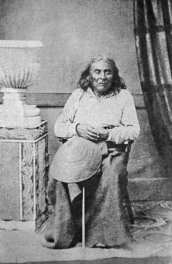
Seattle Boulevard was obviously named for the city, which itself was named after Si’ahl [siʔaɫ], better known in English as Chief Seattle of the Duwamish and Suquamish Tribes.
Since 2010, then, there have been two streets in the city that bear its and siʔaɫ’s name: Seattle Boulevard S and SW Seattle Street.
Born and raised in Seattle, Benjamin Donguk Lukoff had his interest in local history kindled at the age of six, when his father bought him settler granddaughter Sophie Frye Bass’s Pig-Tail Days in Old Seattle at the gift shop of the Museum of History and Industry. He studied English, Russian, and linguistics at the University of Washington, and went on to earn his master’s in English linguistics from University College London. His book of rephotography, Seattle Then and Now, was published in 2010. An updated version came out in 2015.
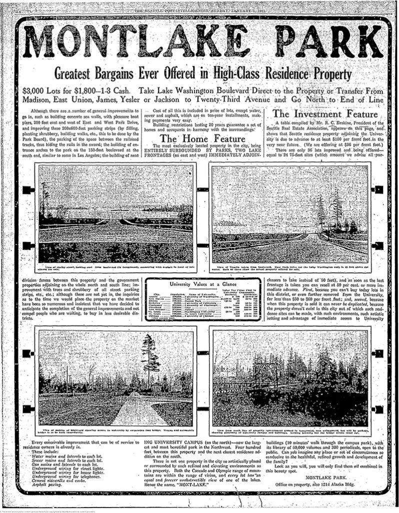
Montlake Park ad, Seattle P-I, January 1, 1911. “Both the Cascade and Olympic range of mountains are within the range of vision, and every lot has an equal and forever unobstructible view of one of the lakes [Lake Union and Lake Washington]. Hence the name, ‘MONT-LAKE.’”
Today, Montlake Boulevard E (as well as Washington State Route 513) begins at the intersection of E Lake Washington Boulevard and E Montlake Place E, just south of the Washington State Route 520 freeway, and goes 1⅓ miles north, then northeast, to NE 45th Street, just south of University Village. It becomes Montlake Boulevard NE as it crosses the Montlake Cut of the Lake Washington Ship Canal. (State Route 513 continues for another 2 miles along NE 45th Street and Sand Point Way NE, ending at NE 65th Street just west of Magnuson Park.)
Born and raised in Seattle, Benjamin Donguk Lukoff had his interest in local history kindled at the age of six, when his father bought him settler granddaughter Sophie Frye Bass’s Pig-Tail Days in Old Seattle at the gift shop of the Museum of History and Industry. He studied English, Russian, and linguistics at the University of Washington, and went on to earn his master’s in English linguistics from University College London. His book of rephotography, Seattle Then and Now, was published in 2010. An updated version came out in 2015.
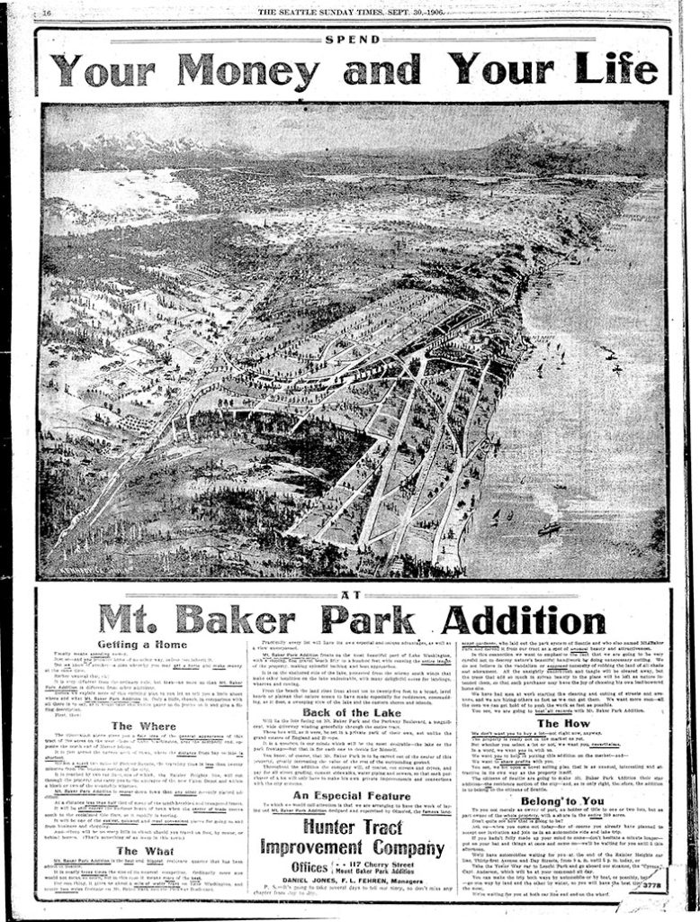
According to the Mount Baker Historic Context Statement, “Since Mount Baker Park was designed to be an exclusive single-family residential community, one of the early concerns of the Mount Baker Park Improvement Club was related to social issues, and what became known as the ‘Restrictions Committee’”:
[This committee] was involved in enforcing the restrictions contained in the deeds regarding single family housing only and the restrictive covenants that prevented non-whites from purchasing property in the area. The club passed a resolution stating that the club was against using any lot for clubs, schools, boarding or lodging houses, churches, charitable or religious societies or orders or for any other purpose than strictly detached family residences.
Discrimination in Mount Baker continued for decades, though it did eventually become a became a “locus for pushback against racial injustice.” The Seattle Star headlines below illustrate both the discrimination and early examples of resistance:
The first article, ‘Hunter Tract lots are not for colored people,’ appeared on April 2, 1909. An excerpt:
The owners of the Hunter tract, a fashionable residence addition overlooking Lake Washington, don’t intend to permit any colored people to build homes on their property.… F.H. Stone and Susie B. Stone are colored.… Arrangements were made by the Stones to erect a dwelling upon [their] lot. According to the officers of the investment company, it was then that they first discovered that the Stones were colored people.… [They] contended that if the Stones were permitted to build their dwelling and to occupy it, values of surrounding property would be decreased and a pecuniary hardship would therefore be worked upon the owners of the Hunter tract.
The case went to trial before Judge John F. Main. ‘No color line is drawn in Seattle’ appeared on November 6, 1909, the day after he rendered his decision:
The incident of color or race cannot of itself annul the terms of a contract, and there is no Mason and Dixon’s line in the residence district of Seattle.… Judge Main held, in substance, that no negro, because of his color, is legally barred from acquiring property and holding the same in the most exclusive community or from residing next door to his white neighbor.
Meanwhile, another related case was working its way through the courts. ‘Negro given right to live in Mt. Baker’ read the headline on February 1, 1910:
David Cole, a well-to-do negro… bought [a lot] from the Hunter Tract company. The officials of the company did not know that he was a negro until he came to the office to get his deed. Daniel Jones, agent for the firm, tried to buy him off… Cole insisted on having his deed and Jones refused to give it to him. Cole took the case to court and Judge Frater this morning decided that Jones must give Cole the deed. Jones immediately gave notice of appeal. Jones contended that Cole’s presence in the tract would lower property values from 40 to 50 per cent but Judge Frater held that a contract is a contract.
Born and raised in Seattle, Benjamin Donguk Lukoff had his interest in local history kindled at the age of six, when his father bought him settler granddaughter Sophie Frye Bass’s Pig-Tail Days in Old Seattle at the gift shop of the Museum of History and Industry. He studied English, Russian, and linguistics at the University of Washington, and went on to earn his master’s in English linguistics from University College London. His book of rephotography, Seattle Then and Now, was published in 2010. An updated version came out in 2015.
S Mount Baker Boulevard, intended to connect Lake Washington Boulevard to Beacon Hill, begins at S McClellan Street and Lake Park Drive S (the latter of which leads to Lake Washington Boulevard) and goes just over ½ a mile west to Rainier Avenue S and Martin Luther King Jr. Way S. West of the intersection, the boulevard continues as S Winthrop Street, which connects to Cheasty Boulevard S leading up Beacon Hill.
Born and raised in Seattle, Benjamin Donguk Lukoff had his interest in local history kindled at the age of six, when his father bought him settler granddaughter Sophie Frye Bass’s Pig-Tail Days in Old Seattle at the gift shop of the Museum of History and Industry. He studied English, Russian, and linguistics at the University of Washington, and went on to earn his master’s in English linguistics from University College London. His book of rephotography, Seattle Then and Now, was published in 2010. An updated version came out in 2015.
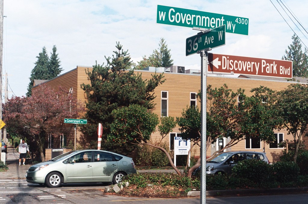
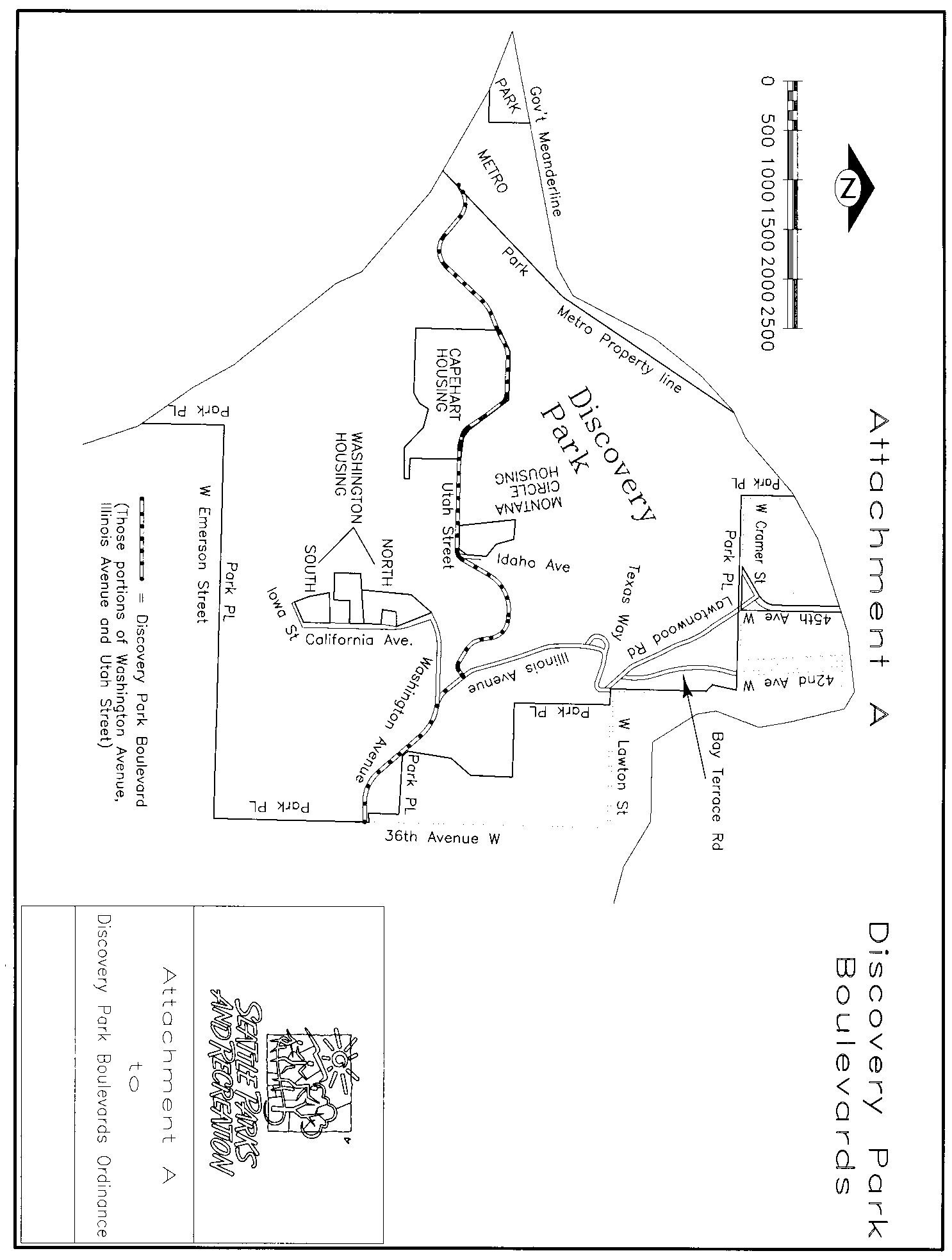
Unlike Seattle’s other park boulevards, Discovery Park Boulevard is of recent creation. Ordinance 122503, passed in 2007, designated numerous streets within the park as park boulevards, one reason being that:
Public safety will be enhanced within Discovery Park as traffic codes and regulations are fully enforceable on Park Boulevards as they are on City of Seattle streets, but not necessarily on park roads which are considered “private.”
(More on this at Lawtonwood Road.) Among the streets so designated were Lawtonwood Road, Bay Terrace Road, Utah Street, Washington Avenue, California Avenue, Iowa Street, Illinois Avenue, Texas Way, Idaho Avenue, and 45th Avenue W. The ordinance specified that Washington Avenue from the park entrance to Illinois Avenue; Illinois Avenue from there to Utah Street; and Utah Street from there to King County’s West Point Treatment Plant were to be known as Discovery Park Boulevard (see this map for an illustration).
The person who first suggested the name “Discovery Park” was U.S. District Judge Donald S. Voorhees, who had led the effort to create a park at Fort Lawton in 1968…. Voorhees was a student of Puget Sound history and Vancouver’s exploration. But he was also an avid follower of the philosophy of Frederick Law Olmsted, the famed American landscape architect. Voorhees believed the name combined the history of Vancouver’s exploration of Puget Sound on the HMS Discovery with the excitement of visitors when they discover the wonders of nature in the Park. When asked to make a choice between the meanings, Voorhees would choose the experience of “discovery” by citizens, particularly children, visiting the Park for the first time, over the historical connection with the HMS Discovery.
Born and raised in Seattle, Benjamin Donguk Lukoff had his interest in local history kindled at the age of six, when his father bought him settler granddaughter Sophie Frye Bass’s Pig-Tail Days in Old Seattle at the gift shop of the Museum of History and Industry. He studied English, Russian, and linguistics at the University of Washington, and went on to earn his master’s in English linguistics from University College London. His book of rephotography, Seattle Then and Now, was published in 2010. An updated version came out in 2015.
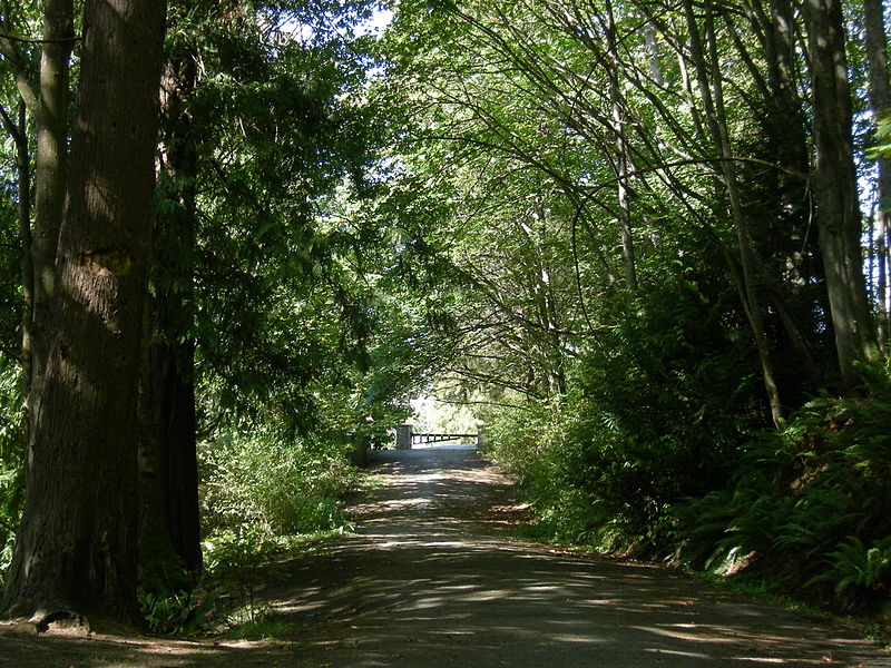
This road, and the park through which it runs, Schmitz Park (or Schmitz Preserve Park), was named for German immmigrants Ferdinand Schmitz (1860–1942) and his wife, Emma Althoff Schmitz (1864–1959). Ferdinand was a banker, city councilman, and parks commissioner. He and Emma donated land — mostly, though not entirely, old-growth forest — to the city in 1908, forming the core (just over 55%) of the present park.
The Schmitzes had four children: Dietrich, Henry, Emma Henrietta, and Ferdinand Jr. A banker, Dietrich (1890–1969) became president of Washington Mutual in 1934 and retired as chairman of the board two years before his death. He was also a member of the Seattle School Board from 1928 (or 1930; sources differ) to 1961. Henry (1892–1965) was president of the University of Washington from 1952 to 1958. Schmitz Hall, the university’s administration building on NE Campus Parkway, was named in his memory in 1970.
The roadway was originally envisioned as a continuation of the West Seattle Parkway, never realized, which would have connected Alki Beach to Lake Washington via a series of parkways. The built section is instead a short road that provided the only automobile entry to Schmitz Park, extending through an allée of trees and terminating at a pergola and shelterhouse.
Map of proposed West Seattle Parkway, cropped from a 1928 map showing both existing (red) and proposed (red hatched) park features. Schmitz Park and Boulevard are at upper left. Courtesy of the Seattle Municipal Archives, Identifier 2333.
The portion between 59th Avenue SW and 58th Avenue SW in front of Alki Elementary School having been closed in 1949, Schmitz Boulevard today begins at 58th Avenue SW and SW Stevens Street and goes not quite half a mile east, then southeast, then north, to SW Admiral Way and SW Stevens Street. It is closed to automobile traffic.
Emma Schmitz
Ferdinand Schmitz
Emma and Ferdinand Schmitz. Her photo is from the December 24, 1959, issue of the Seattle Post-Intelligencer (she had died December 23); his is from the August 23, 1942, issue of The Seattle Times (he had died August 21).
Born and raised in Seattle, Benjamin Donguk Lukoff had his interest in local history kindled at the age of six, when his father bought him settler granddaughter Sophie Frye Bass’s Pig-Tail Days in Old Seattle at the gift shop of the Museum of History and Industry. He studied English, Russian, and linguistics at the University of Washington, and went on to earn his master’s in English linguistics from University College London. His book of rephotography, Seattle Then and Now, was published in 2010. An updated version came out in 2015.
Puget Boulevard is a curious street, for a number of reasons:
The paved portions are only a few blocks long — hardly comparable to, say, Lake Washington Boulevard or Magnolia Boulevard;
Both east–west and north–south portions are called Puget Boulevard SW, contrary to the rule that directional designations precede street names for east–west streets (this is why Lake Washington Boulevard E becomes E Lake Washington Boulevard when it curves west on its approach to Montlake Boulevard E);
Despite its name, it has no view of Puget Sound, sitting as it does in the Longfellow Creek valley in the Delridge neighborhood of West Seattle;
And, as it turns out, it isn’t even named for Puget Sound, as might be expected, but rather for the Puget Mill Company (later part of Pope & Talbot and today part of Rayonier).
“A rugged tract of logged-off land south of Pigeon Point and Youngstown in the large unplatted area” (20.5 acres — this became Puget Park); and
“A strip of land 160 feet in width extending from Sixteenth Avenue Southwest and Edmonds Street (sic) to Thirty-fifth Avenue Southwest and Genessee Street, a distance of 8,500 feet, and comprising an area of about fifteen acres for parkway purposes. Under the conditions of this gift improvement work must be undertaken within five years. This acquisition forms an important link in the contemplated boulevard to West Seattle.”
This strip is today’s Puget Boulevard SW. Two things become apparent when looking at the King County Parcel Viewer map of West Seattle:
Map of Puget Boulevard, from King County Parcel Viewer
Once past the present site of West Seattle Stadium, the “contemplated boulevard to West Seattle” was to have run, as the Friends of Seattle’s Olmsted Parks puts it,
[Across] California Avenue a few blocks north of [the] present-day Alaska Junction, at that time part of the “Boston Subdivision.” It would have then headed northwest and down a ravine, eventually turning southwest to terminate at Alki Point.
Map of proposed West Seattle Parkway, cropped from a 1928 map showing both existing (red) and proposed (red hatched) park features. Puget Park and Boulevard are at lower right. Courtesy of the Seattle Municipal Archives, Identifier 2333.
Returning to the question of the name — the Puget Mill Company was, of course, named after Puget Sound, which itself was named in 1792 by Captain George Vancouver of HMS Discovery for Lieutenant Peter Puget (1765–1822).
Today, the paved portion of Puget Boulevard SW begins at 23rd Avenue SW, about 1⁄10 of a mile north of SW Hudson Street, and goes ⅕ of a mile south to a dead end. After a very short section — not more than 150 feet long — east of Delridge Way SW, which serves as a driveway for a complex of townhouses, it resumes west of a foot path off Delridge and goes about 1⁄10 of a mile west to 26th Avenue SW. Along this stretch, there are houses to the north and the Delridge P-Patch and Puget Boulevard Commons to the south.
Born and raised in Seattle, Benjamin Donguk Lukoff had his interest in local history kindled at the age of six, when his father bought him settler granddaughter Sophie Frye Bass’s Pig-Tail Days in Old Seattle at the gift shop of the Museum of History and Industry. He studied English, Russian, and linguistics at the University of Washington, and went on to earn his master’s in English linguistics from University College London. His book of rephotography, Seattle Then and Now, was published in 2010. An updated version came out in 2015.
Like Queen Anne Avenue N, Queen Anne Boulevard is named for the neighborhood and hill, themselves named for the Queen Anne architectural style popular with builders in the 1880s. Unlike the avenue, though, the boulevard is not one single street, but a scenic loop incorporating many streets (and hence has no directional designation, such as Queen Anne Boulevard W).
The legislation establishing Queen Anne Boulevard was passed in 1907, and construction took place from 1911 to 1916. The Seattle Department of Transportation has had jurisdiction over the streets since 1942; jurisdiction over the landscaping remains with Seattle Parks and Recreation.
The loop is slightly over 3⅔ miles in length; the ordinance gives its route as follows (edited for style and current street names and directional designations, with notes added):
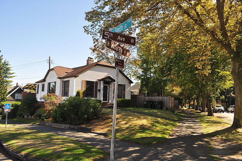
Extending from Prospect Street between Warren Avenue N and 2nd Avenue N, in a northeasterly direction*, to an intersection with Galer Street near Bigelow Avenue N; thence northerly following the general direction of Bigelow Avenue N as nearly as the contours of the ground will permit, to Wheeler Street; thence westerly to Nob Hill Avenue N; thence southerly to McGraw Street; thence westerly to 2nd Avenue N; thence northwesterly to Smith Street†, west of Warren Avenue N; thence westerly along Smith Street to a point east of 1st Avenue W; thence southerly to W McGraw Street and 2nd Avenue West‡; thence westerly to 3rd Avenue W; thence northwesterly to 5th Avenue W and W Smith Street§; thence northerly to W Raye Street; thence westerly to 8th Avenue W; thence northerly to W Armour Street; thence northwesterly to W Fulton Street; thence westerly to 9th Avenue W; thence southwesterly to 10th Avenue W and W Armour Street; thence southerly to W Wheeler Street; thence easterly to 8th Avenue W; thence southerly to W McGraw Street; thence easterly to 7th Avenue W; thence southerly to W Blaine Street; thence westerly to 8th Avenue W; thence southerly to W Lee Street; thence southeasterly to W Highland Drive and 7th Avenue West¶.
* Now the southern extension of Bigelow Avenue N. † Now McGraw Place. ‡ Now the east half of W McGraw Place. § Now the west half of W McGraw Place. ¶ Now 8th Place W.
Notably, there is a gap in the loop; Highland Drive between 7th Avenue W and Warren Avenue N could have made it closed, but this was not done.
“Queen Anne Boulevard, Seattle Historic Landmark” Parks Department sign, 1st Avenue W and W Smith Street, July 2015. Courtesy of the Seattle Municipal Archives, Identifier 178301
Queen Anne Boulevard at night: 8th Place W just north of Marshall Park, July 2015. Note the Wilcox Wall supporting the light fixtures. Courtesy of the Seattle Municipal Archives, Identifier 178303
Born and raised in Seattle, Benjamin Donguk Lukoff had his interest in local history kindled at the age of six, when his father bought him settler granddaughter Sophie Frye Bass’s Pig-Tail Days in Old Seattle at the gift shop of the Museum of History and Industry. He studied English, Russian, and linguistics at the University of Washington, and went on to earn his master’s in English linguistics from University College London. His book of rephotography, Seattle Then and Now, was published in 2010. An updated version came out in 2015.
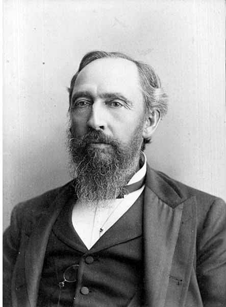
This street, which appears to have been established as part of the 1906 Replat of McGilvra’s Addition and Second Addition to the City of Seattle (an abbreviation of its much longer name), was named for John J. McGilvra (1827–1903). Born in Livingston County, New York, McGilvra moved to Illinois at the age of 17, and became a lawyer nine years later. In 1861, President Abraham Lincoln, who McGilvra reportedly knew as a fellow Illinois lawyer, appointed him United States Attorney for the Territory of Washington. In 1864, he moved to Seattle. That same year, he and his wife, Elizabeth, bought 420 acres of land in what is now Madison Park and became the area’s first settlers. McGilvra had Madison Street extended to the lakefront — it is still the only street to extend from Elliott Bay to Lake Washington without interruption — and later helped establish the Madison Street Cable Railway Company and Madison Park at its eastern terminus. In 1865 he relinquished the post of U.S. attorney. He was a member of the Territorial Legislature in 1866 and 1867, and Seattle city attorney in 1876 and 1877. He retired in 1890.
John J. McGilvra, circa 1890
Today, McGilvra Boulevard E begins in the south at 39th Avenue E and Lake Washington Boulevard E and goes 1⅖ miles north to E McGilvra Street. Unlike most other boulevards in the city, it is not an Olmsted boulevard — McGilvra was reportedly opposed to the movement that resulted in the hiring of the Olmsted Brothers in 1903 (the year of his death) to design a system of parks and boulevards for Seattle, though there is no evidence the two are directly related.
Born and raised in Seattle, Benjamin Donguk Lukoff had his interest in local history kindled at the age of six, when his father bought him settler granddaughter Sophie Frye Bass’s Pig-Tail Days in Old Seattle at the gift shop of the Museum of History and Industry. He studied English, Russian, and linguistics at the University of Washington, and went on to earn his master’s in English linguistics from University College London. His book of rephotography, Seattle Then and Now, was published in 2010. An updated version came out in 2015.
This street, created in 1906 as part of the Lake Shore View Addition to Seattle, begins in the north at NE 105th Street and Exeter Avenue NE, and curves south for a mile along the Burke-Gilman Trail, which parallels the Lake Washington shoreline, to a dead end at the north boundary of Matthews Beach Park. Unlike most, though not all, boulevards in Seattle, this one is not one of the Olmsted boulevards designed by John Charles Olmsted in 1903.
Born and raised in Seattle, Benjamin Donguk Lukoff had his interest in local history kindled at the age of six, when his father bought him settler granddaughter Sophie Frye Bass’s Pig-Tail Days in Old Seattle at the gift shop of the Museum of History and Industry. He studied English, Russian, and linguistics at the University of Washington, and went on to earn his master’s in English linguistics from University College London. His book of rephotography, Seattle Then and Now, was published in 2010. An updated version came out in 2015.
Lakeview Boulevard E, which originated in David and Louisa Denny’s 1886 East Park Addition to the City of Seattle, is named for its view of Lake Union to the west. For a time part of the Pacific Highway (now routed onto Aurora Avenue N), it begins today at an overpass over Interstate 5 at Eastlake Avenue E and Mercer Street and goes a mile north to Boylston Avenue E and E Newton Street.
Interstate 5 blocks the view of the lake from much of the northern section of the street, but the southern section’s view is still more or less intact.
Born and raised in Seattle, Benjamin Donguk Lukoff had his interest in local history kindled at the age of six, when his father bought him settler granddaughter Sophie Frye Bass’s Pig-Tail Days in Old Seattle at the gift shop of the Museum of History and Industry. He studied English, Russian, and linguistics at the University of Washington, and went on to earn his master’s in English linguistics from University College London. His book of rephotography, Seattle Then and Now, was published in 2010. An updated version came out in 2015.
This Olmsted boulevard was designed in 1910 as Jefferson Boulevard, the entrance to Jefferson Park. It runs about 1⅕ miles from Beacon Avenue S and S Alaska Street in the southwest to S Winthrop Street in the northeast, which also forms part of the park boulevard. After crossing Martin Luther King Jr. Way S and Rainier Avenue S, it continues on as S Mount Baker Boulevard, ending at Mount Baker Park.
In 1914, it was renamed Cheasty Boulevard after E.C. (Edward) Cheasty (born 1864), who died that year. He had been police commissioner, commissioner of the Alaska–Yukon–Pacific Exposition, and a member of the park board from 1907 to 1910 and 1912 to his death, according to the Don Sherwood Park History Files. He also ran Cheasty’s Store, a downtown haberdashery, from 1888 until his death.
Speaking of his death, it sadly appears that it was due to suicide. He fell from the 10th floor of the Washington Hotel — the same hotel in which fellow businessman Frank B. Hubbell killed himself in 1905.
Front-page article on Cheasty’s death, The Seattle Star, June 13, 1914
Born and raised in Seattle, Benjamin Donguk Lukoff had his interest in local history kindled at the age of six, when his father bought him settler granddaughter Sophie Frye Bass’s Pig-Tail Days in Old Seattle at the gift shop of the Museum of History and Industry. He studied English, Russian, and linguistics at the University of Washington, and went on to earn his master’s in English linguistics from University College London. His book of rephotography, Seattle Then and Now, was published in 2010. An updated version came out in 2015.
The establishment of E Interlaken Boulevard — the first of Seattle’s Olmsted parks and boulevards we’re covering — was first proposed, according to Seattle parks historian Don Sherwood, in 1903 as Volunteer Hill Parkway. Two years later, the current name was adopted. There is speculation, but no documentation, that it was named for the Swiss resort town of that name. Ask a Seattleite how to pronounce “Interlaken” and you may hear either lake or lock, the latter being more common according to an informal Twitter poll I ran (but the former being the one I grew up with).
Note: On July 10, 2024, I began converting embedded tweets on this website to screenshots because of issues with how they were integrating with WordPress, which began not too long after Elon Musk purchased Twitter and changed its name to X. Here is a screen shot of folks’ comments.
Interlaken Boulevard runs for about 1⅔ miles west to east from Delmar Drive E, by Seattle Preparatory School on Capitol Hill, to Lake Washington Boulevard E, in the Washington Park Arboretum. The middle section, between 19th and 21st Avenues E, is closed to motor vehicles and functions as a pedestrian and bicycle trail. The name also appears on Interlaken Drive E and Interlaken Place E — and should not be confused with Interlake Avenue N, a street in North Seattle.
Born and raised in Seattle, Benjamin Donguk Lukoff had his interest in local history kindled at the age of six, when his father bought him settler granddaughter Sophie Frye Bass’s Pig-Tail Days in Old Seattle at the gift shop of the Museum of History and Industry. He studied English, Russian, and linguistics at the University of Washington, and went on to earn his master’s in English linguistics from University College London. His book of rephotography, Seattle Then and Now, was published in 2010. An updated version came out in 2015.


.jpg)
.jpg)
.jpg)