Mountain View Drive S

This street, created in 1923 by Ordinance 45500, received its current name in 1929. Before then, it was part of 28th and 29th Avenues S. The mountain in question would be Mount Rainier, which, it was recently announced, is no longer 14,410 feet high, but rather 14,399.6, due to a melting icecap.

Mountain View Drive S begins at S Columbian Way and S Alaska Street and goes ⅙ of a mile southeast to 29th Avenue S and S Edmunds Street.

Montvale Place W

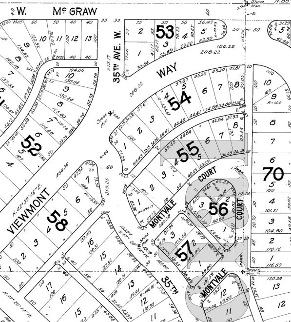
What is now Montvale Place W was originally Montvale Court W, created in 1915 as part of the plat of Carleton Park. When originally platted, Montvale Court formed a horseshoe-shaped loop, but at some point (the quarter section map doesn’t say, and I can find no relevant city ordinance), the eastern and southeastern part of the street, plus the alley connecting to 34th Avenue W, was renamed Montvale Place W.

Montvale Place W begins at 35th Avenue W south of Montvale Court W and goes ⅛ of a mile northeast, then north, to the intersection of Viewmont Way W, 34th Avenue W, and W Lynn Street.

Portion of plat of Carleton Park showing original course of Montvale Court W
Portion of plat of Carleton Park showing original course of Montvale Court W, over half of which is now Montvale Place W

Montvale Court W

Like Viewmont Way W, Crestmont Place W, Eastmont Way W, Westmont Way W, and Piedmont Place W, this street was created in 1915 as part of the plat of Carleton Park, their common mont element referring to the fact that, as The Seattle Times wrote, the “entire district commands an unobstructible view of the Cascade and Olympic Mountains.” Like Piedmont Place W, Montvale Court W lies at the foot of the western Magnolia hill as it slopes down to Pleasant Valley (of which vale is of course a variant).

Montvale Court W begins at 35th Avenue W south of Viewmont Way W and goes just over 300 feet northeast to Montvale Place W. (When it was originally platted, it formed a horseshoe-shaped loop back to 35th, but at some point the eastern and southeastern part of the street was renamed Montvale Place W.)

Portion of plat of Carleton Park showing original course of Montvale Court W

Chris Curtis Way

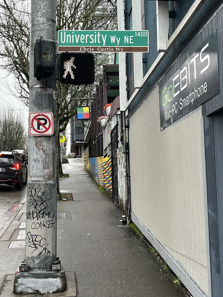
In March 2019, the block of University Way NE between NE 50th Street and NE 52nd Street was given the honorary name of Chris Curtis Way. This block is home to the weekly, year-round University District Farmers Market. Founded in 1993 by Chris Curtis and others, it was the first of what are now seven farmers markets spread across the city. As the city council resolution states, Curtis received this honor for, among other things,

…Organiz[ing] the first neighborhood farmers markets in Seattle devoted exclusively to local, small-scale family farms, which focus on good land stewardship and biodiversity and are essential components of a healthy environment, thriving local economy, and safe food system; and… help[ing] to preserve farmers’ livelihoods, revitalize neighborhoods, and support and strengthen Washington’s small family farm industry.

Curtis retired as executive director of the Neighborhood Farmers Market Alliance in 2018.

Chris Curtis Way sign, University Way NE, Seattle
Chris Curtis Way sign, University Way NE at NE 50th Street, February 6, 2024. Photograph by Zev Handel, Copyright © 2024 Zev Handel. All rights reserved.

Candy Cane Lane

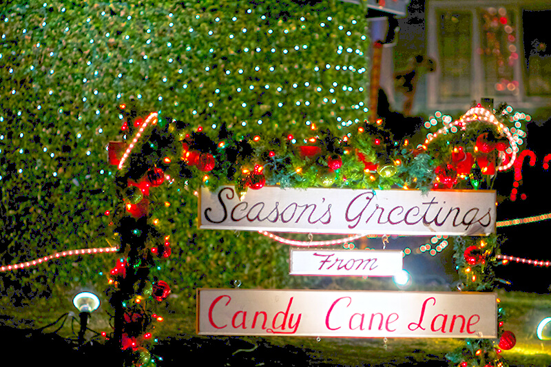
It’s that time of year again, when NE Park Road and Park Road NE (which form a loop connecting Ravenna Avenue NE and 21st Avenue NE north of NE Ravenna Boulevard) transform themselves into Candy Lane Lane. A Christmas tradition which began 75 years ago, it’s, as local historian Valarie Bunn describes it,

A fun family holiday event in northeast Seattle… a cluster of houses all decked out in lights and themed decorations.… Pedestrians are welcome at all times, and you are encouraged to walk through for a closer look at the lights and decorations. 

Visit her blog post or the Candy Cane Lane Facebook page for more details. The display runs through January 1.

Candy Cane Lane Season's Greetings sign, December 2013
Season’s Greetings from Candy Cane Lane sign, December 2013. Photograph by Flickr user Frank Fujimoto, licensed under Creative Commons Attribution-NonCommercial-NoDerivs 2.0 Generic

Seattle Storm Way

This pedestrianized stretch of 2nd Avenue N on the Seattle Center campus was renamed in 2018 after the Seattle Storm WNBA team, themselves so named “because of the weather here and what the team plans to do in the league.” Founded in 2000, their home court is Climate Pledge Arena, located between Seattle Storm Way and 1st Avenue N along Lenny Wilkens Way (formerly the 100 block of Thomas Street)

Before the 1962 Century 21 Exposition that brought Seattle the Space Needle and Monorail, 2nd Avenue N (earlier Poplar Avenue) continued north to Mercer Street and up Queen Anne Hill. The stretch between Thomas and Mercer Streets would remain a public right-of-way after its pedestrianization for nearly 30 years until it was vacated in 1991 at the request of Seattle Center “for the purpose of security and event control.”

Seattle Storm Way begins at Lenny Wilkens Way and goes a block north to the old Harrison Street right-of-way; the walkway between there and Mercer Street remains unnamed.

Seattle Storm logo
Seattle Storm logo

Ridgemont Way N

This street was created in 1925 as part of the plat of Ridgemont. Unnamed at the time, it was presumably later named after the subdivision. I say “presumably” because there is no record of its being named in Seattle’s online legislative database, which there should be if this was done after this part of town was annexed in 1953, and King County’s only goes back to 1969.

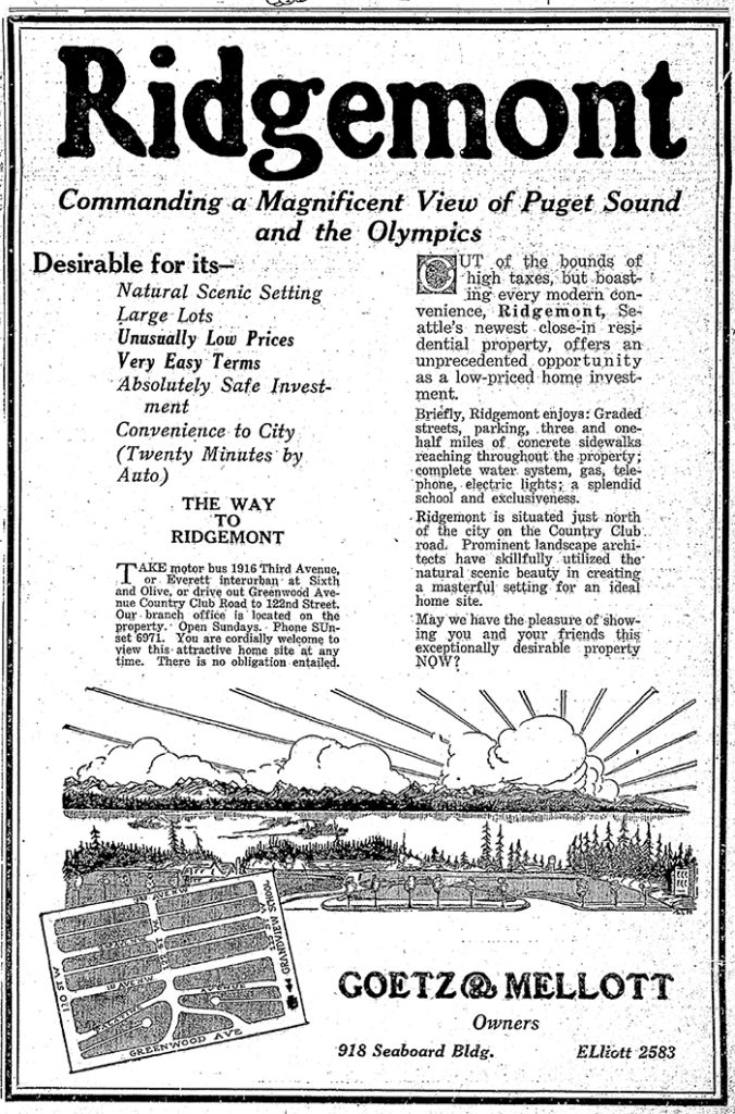
Ridgemont, as the below advertisement implies, was named for its location atop a ridge “commanding a magnificent view of Puget Sound and the Olympics.”

Ridgemont Way N begins at Greenwood Avenue N just south of N 125th Street and goes just over 425 feet southwest to N 122nd Street.

Advertisement for the Ridegmont subdivision, The Seattle Times, October 11, 1925
Advertisement for the Ridegmont subdivision, The Seattle Times, October 11, 1925. It would remain outside of the city and “out of the bounds of high taxes” for 28 years.

Alpine Way NW

This street, like NW Culbertson Drive, was created in 1955 as part of the plat of Llandover-by-the-Sound, and was presumably named for the property’s view of the Olympic Mountains to the west. (I say property, singular, because there is only one house with an Alpine Way address).

Alpine Way NW begins at NW Culbertson Drive and goes just over 325 feet south to NW Northwood Road.

Fairview Place N

This street was created in 1988 as part of the development of Chandler’s Cove, now being redeveloped as Lake Union Piers. Beginning at Fairview Avenue N between Valley Street and Aloha Street and going just over 125 feet north to Waterway 5 on Lake Union, it was presumably named after the avenue.

Fairview Avenue N was itself established as Lake Street in the 1875 plat of the Fairview Homestead Association for the Benefit of Mechanics and Laborers, and received its current name during the Great Renaming of 1895. The name likely references the view of Lake Union and Wallingford that was once visible from most of the Cascade neighborhood.

Stadium Place S

This private street begins at 2nd Avenue S and S King Street and goes 300 feet south to the north parking lot of Lumen Field. It was created in 2011 as part of the Stadium Place development, after which it was named. The development, in turn, was so named for its proximity to Lumen Field, known as Seahawks Stadium from 2002 to 2004, Qwest Field from 2004 to 2011, and CenturyLink Field from 2011 to 2020.

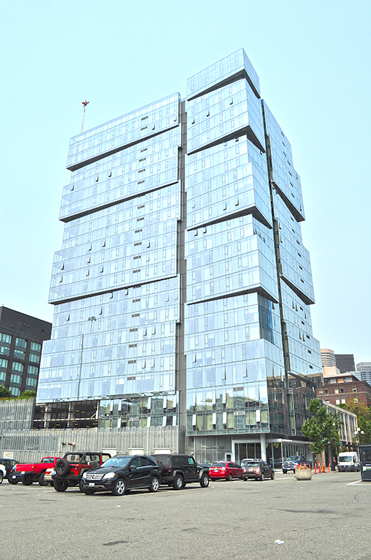
“The Wave” — the west tower of the Stadium Place complex — as seen from the parking lot of Lumen Field in August 2017
“The Wave” — the west tower of the Stadium Place complex — as seen from the parking lot of Lumen Field in August 2017. Stadium Place S is the street to the north of the parking lot, where the white van is parked behind the orange bollards. Photograph by Wikimedia Commons user Joe Mabel, licensed under Creative Commons Attribution 4.0 International.

Convention Place

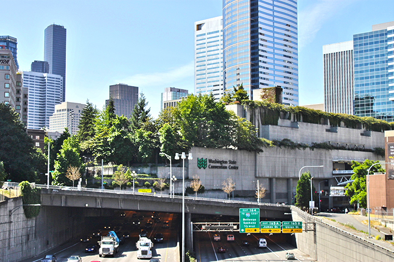
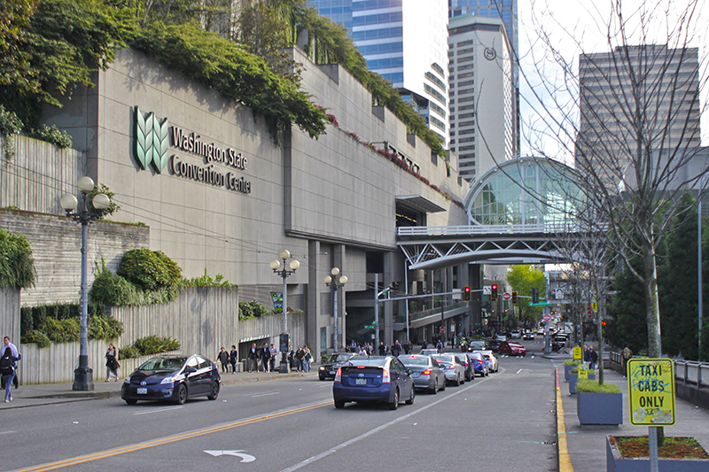
This street was created in 1966 as Union Place, a state-owned frontage road for the recently constructed Interstate 5. (Construction of an earlier, nearby Union Place had been approved and then repealed in 1902.) It was renamed Convention Place in 1988 when the city took ownership as part of the construction of the Washington State Convention Center, which became the Seattle Convention Center in 2022.

Formerly open to the air, Convention Place became a tunnel during the construction of the convention center, which was built over it and Interstate 5. It begins at the intersection of 9th Avenue and Pike Street and goes ⅛ of a mile southwest to Union Street just before its intersection with 7th Avenue.

convention center lid looking south
Looking south from the I-5 Pine Street overpass toward Pike Street and the Convention Center, June 2015. The Paramount Theatre is just visible at far right, and just to the left of that, at 9th Avenue and Pike Street, is where Convention Place begins. Photograph by Flickr user SounderBruce, licensed under Creative Commons Attribution-ShareAlike 2.0 Generic
convention center looking west down pike
Looking southwest down Pike Street from Hubbell Place, May 2017. Convention Place begins at the traffic signal. Photograph by SounderBruce, Wikimedia Commons, licensed under Creative Commons Attribution-ShareAlike 4.0 International

Sound View Terrace W

This street was created in 1905 as part of the plat of the Sound View Addition to Queen Anne. Originally a loop off 11th Avenue W and carrying that name, at some point it was renamed after the addition — which itself was named for its fine view of Puget Sound. (I have been unable to find the renaming ordinance, so don’t know exactly when the change was made.)

Smith Cove from Soundview Terrace Park, July 2008
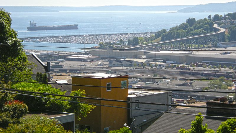
Smith Cove, Interbay, and Magnolia from Soundview Terrace Park, July 2008. The industrial area at center is the Port of Seattle’s Terminal 91, the BNSF Railway’s Balmer Yard, and the Washington National Guard’s Seattle Readiness Center. Beyond the Magnolia Bridge is the Elliott Bay Marina. Photograph by Joe Mabel, Wikimedia Commons, licensed under Creative Commons Attribution-Share Alike 3.0 Unported
Soundview Terrace playground
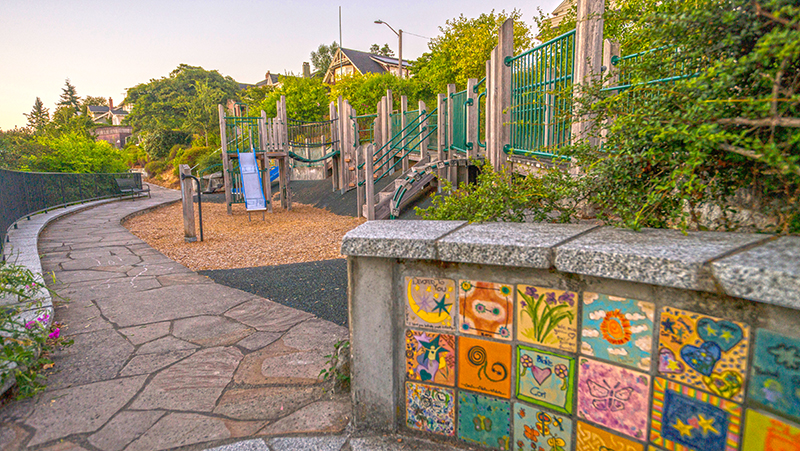
Soundview Terrace Playground, July 2015. Sound View Terrace W is between the playground and the houses, all of which have Westview Drive W or 11th Avenue W addresses. Courtesy of the Seattle Municipal Archives, Identifier 178590
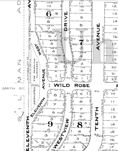
Portion of 1905 Plat of Sound View Addition to Queen Anne
Portion of the 1905 plat. Smith and Wild Rose Streets are now W Wheeler Street; the curving portion of 11th Avenue W is now Sound View Terrace W.

Dzidzilalich

As I wrote in “Dzidzilalich” to be honorary name for Elliott Way, Alaskan Way, the Lushootseed place name Dzidzilalich has become Seattle’s newest honorary street name. Pronounced dzee-dzuh-lah-leech, it means means “Little Crossing Over Place,” and is the name of a Duwamish village whose site is now covered by Downtown Seattle.

Mockup of a brown street sign reading Dzidzilalich

The designation applies to Elliott Way for its entire length, beginning at Western Avenue and Bell Street and heading southeast to where it meets Alaskan Way at Pine Street. It then continues on Alaskan Way to its intersection with S Dearborn Street, for a total length of 1¼ miles. (Why it doesn’t apply to Alaskan Way for its entire length, I am not sure.)

Where springs of clear water bubbled from the earth and the beach was sandy and free from rocks, there the Indians camped. Such a choice spot was Tzee-tzee-lal-litch, which Arthur Denny called Spring Street.

Sophie Frye Bass, “Pig-Tail Days in Old Seattle

Elliott Way

Seattle’s newest street opened to traffic May 1 — but it has a rather old name.

Elliott Way, which also carries the honorary name Dzidzilalich, is named for Elliott Avenue, which in turn was named in 1895 for Elliott Bay — itself named in 1841 after Midshipman Samuel Bonnyman Elliott (1822–1876), part of the Wilkes Expedition.

The new road begins at the intersection of Western Avenue and Bell Street and goes ⅓ of a mile southeast to Alaskan Way and Pine Street.

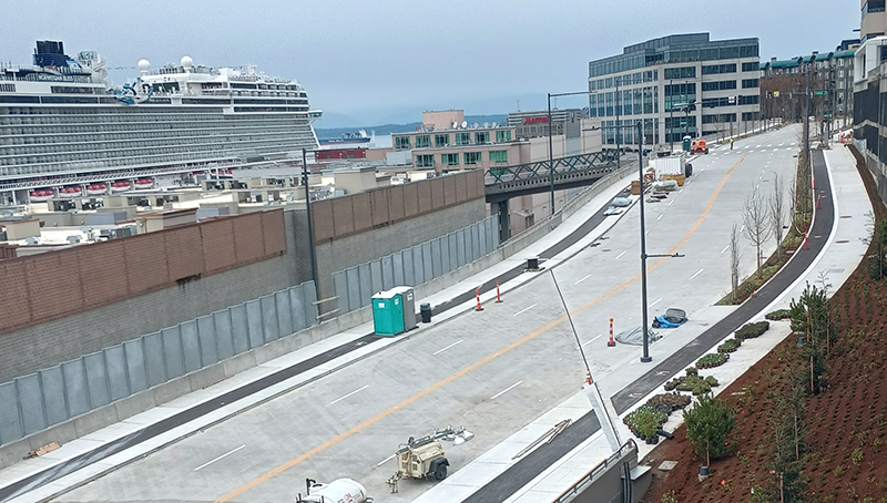
Elliott Way, spring 2023, looking north
Looking north on Elliott Way, shortly before opening, spring 2023. The Lenora Street pedestrian bridge can be seen crossing the railroad tracks at center; the Norwegian Bliss cruise ship is at upper left, docked at the Bell Street Cruise Terminal (Pier 66). Photograph courtesy of Ryan Packer. Copyright © 2023 Ryan Packer. All rights reserved.
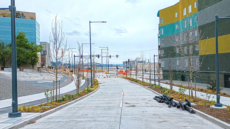
Elliott Way, spring 2023, looking south
Looking south on Elliott Way, shortly before opening, Spring 2023. The Elliott Pointe building is at right and the “Blanchard Street Opportunity Site” at left. The intersection of Elliott Way and Elliott Avenue is at center. Photograph courtesy of Ryan Packer. Copyright © 2023 Ryan Packer. All rights reserved.

Montavista Place W

Created in 1915 as part of the plat of Carleton Park, this is one of the many streets in the subdivision that features the mont element ― Piedmont Place W, Viewmont Way W, Crestmont Place W, Eastmont Way W, and Westmont Way W among them ― a reference to the “entire district[’s]… unobstructible view of the Cascade and Olympic Mountains” (The Seattle Times).

Montavista Place W begins at Magnolia Boulevard W and goes ⅖ of a mile northeast, then northwest, to 38th Avenue W.

E Shore Drive

This private road in the gated Broadmoor neighborhood goes just under 800 feet from Broadmoor Drive E in the west to just east of Waverly Way E in the east. The northernmost street in the development, it runs parallel to the Union Bay shoreline about 950 feet to the northwest, whence its name.

My most well-worn streets

As I was driving on the Magnolia Bridge with my wife the other day, I found myself wondering: What streets have I spent the most time traveling on?

I’ve lived in Seattle for the vast majority of my life, so the candidates must obviously be in this area. For the two other cities where I’ve stayed long enough to need an apartment (London and Washington, D.C.) I’d guess the answers would be Finchley Road and Independence Avenue SE — in both cases the nearest arterial to where I was staying, and on the direct route to school (London) or work (D.C.). For Seattle, I’m not sure.

I’ve lived in four neighborhoods during my time here — around 20 years where I grew up, in Washington Park; five in Hawthorne Hills (or Bryant, depending on who you ask); 11 in Roosevelt; and the last 10 in Magnolia. I wonder: would the answers be the quickest way out of my part of the neighborhood (34th Avenue E, NE 55th Street, Roosevelt Way NE, W Dravus Street)? The closest arterial (same, except replace 34th Avenue E with E Madison Street)? Or something else? I walked to school growing up — so maybe 36th Avenue E for that period?

I have no idea how I’d go about actually calculating this. I do know that, as the son of two professors at the University of Washington, and an alumnus myself (class of 1997), I’ve spent a lot of time on Lake Washington Boulevard E, Montlake Boulevard E, and University Way NE, too — though since I moved to Magnolia I’m hardly ever on any of them, and spend a lot more time on 28th Avenue W, 15th Avenue W, Elliott Avenue W, and the only three ways out of my neighborhood, because of the BNSF Railway tracks: W Emerson Street, W Dravus Street, and the Magnolia Bridge (W Garfield Street).

Anyway, I’d be interested in knowing what other folks think: how would you calculate this for yourself — and what are your most well-worn streets?

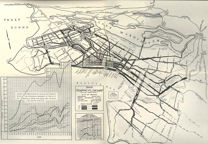
City of Seattle 1949 traffic flow map. Courtesy of the Seattle Municipal Archives, Identifier 3268. Linked to from their online exhibit “Traffic Flow Maps.” Note no data north of 85th Street — it would be five years before the city limits were extended to 145th Street, where they remain today. Also note that since this map was made 18 years before the completion of Interstate 5 through Seattle, traffic leaving the city to the north mostly takes 15th Avenue NW, Victory Way (now Lake City Way NE), and Aurora Avenue N (then U.S. Route 99, today State Route 99). Most traffic to the south leaves the city on E Marginal Way S (also part of Route 99). Lastly, it may be surprising to see that traffic on the Lacey V. Murrow Memorial Bridge to Mercer Island (then U.S. Route 10; today, on a new pair of bridges, Interstate 90) is less than on any of the Ship Canal crossings: the Ballard Bridge, Fremont Bridge, Aurora Bridge, University Bridge, and Montlake Bridge beat it by anywhere from 75% to 200%. Today, of course, it’s quite the reverse — traffic on I-90 dwarfs that on all Seattle bridges with the exception of the Ship Canal Bridge that carries Interstate 5.

“Dzidzilalich” to be honorary name for Elliott Way, Alaskan Way

Contrary to what I wrote in “Elliott Way” just a placeholder name, it sounds like the new road connecting Western Avenue at Bell Street to Alaskan Way at Pike Street will in fact carry the official name of Elliott Way. To quote from a post on Mayor Bruce Harrell’s blog,

Mayor Bruce Harrell, City Council President Debora Juarez, and key waterfront leaders are proposing to establish an honorary name for Alaskan Way and Elliott Way, between S Dearborn St and Bell St. “Dzidzilalich” (pronounced: dzee-dzuh-lah-leech) means “Little Crossing Over Place” in the Coast Salish language Lushootseed. This honorary name would recognize the deep tribal history and culture on Seattle’s waterfront. The Dzidzilalich street name designation would be honorary; the legal name of “Alaskan Way” would not change nor would the official addresses on the street.

As I wrote in Rob Mattson Way, honorary renamings differ from official (re)namings in three important ways:

  • They are done via resolution rather than ordinance
  • They do not replace the original street name in official records and addresses
  • They appear on brown, rather than green, signs

The Waterfront Seattle page on Dzidzilalich notes that “The Suquamish and Muckleshoot Tribal Councils provided guidance to the city of Seattle’s Mayor’s Office, the Office of the Waterfront and Civic Projects, and the Seattle Department of Transportation in the process of selecting Dzidzilalich as the honorary name for this roadway.”

Mockup of a brown street sign reading Dzidzilalich

I am glad to hear that this new street will carry a Lushootseed name. To the best of my knowledge only Duwamish Avenue S and Shilshole Avenue NW do so currently. To have a major downtown street with a name like this is long overdue.

I should also note that, if this is what the tribes want, I support the proposal — and though I have some issues with it, it is not my place to tell tribal members they deserve more. I have no idea what the negotiations looked like. That said, I do have some issues with the proposal.

First, “Elliott Way” remains an incredibly uncreative name for the new roadway. I said it before and I’ll say it again: “This is a [missed] opportunity to commemorate someone, or something, new, rather than Jared, George, Samuel, or Jesse Elliott (apparently no one is sure just which Elliott the bay is named after)!” There is nothing wrong with dead white men, but take a look at the tag cloud at the bottom of this post for proof that they are far overrepresented when it comes to Seattle street names.

Second, honorary names simply don’t carry the same heft as official ones. No one calls 19th Avenue between E Madison Street and E Union Street “Rev. Dr. S. McKinney Ave,” or 15th Avenue S between S Nevada Street and S Columbian Way “Alan Sugiyama Way.” But they do call Mary Gates Memorial Drive NE, E Barbara Bailey Way, Edgar Martinez Drive S, S Roberto Maestas Festival Street, etc., by those names… because they have no other choice.

I do like the idea of giving Alaskan Way an honorary name. It is far too long and important a street to officially rename without causing a lot of issues. The last time we did something like that was when Empire Way became Martin Luther King Jr. Way in the 1980s. I’m glad that happened, but think the process would be even more drawn out and controversial today. (However, if the street that runs along our waterfront carried the name of, say, a Confederate general, I’d be among the first to call for those signs to come down.) But why just this portion of Alaskan Way? To the best of my knowledge we’ve never given an existing street an honorary name for its entire length. Why not start here, from E Marginal Way S all the way to W Garfield Street?

In addition, one reason behind honorary namings is that existing addresses don’t need to be changed. But Elliott Way is new. There are no existing addresses. Why not, then, simply call it Dzidzilalich, and give Alaskan Way another honorary name? Or, why not give Alaskan Way the honorary name Dzidzilalich for its entire length, and give Elliott Way a different name that “elevate[s] Coast Salish tribal history and culture,” as the mayor’s blog puts it?

A few asides: I, personally, would prefer the spelling Dᶻidᶻəlalič, which uses Lushootseed orthography. (If Port Angeles can do it with their Klallam-language street signs, so can we!) And I notice that only the Suquamish and Muckleshoot tribes are mentioned as having been consulted. I wonder if representatives of the Duwamish Tribe were given a chance to weigh in as well. (My guess is they weren’t, as they are not federally recognized, while the Suquamish and Muckleshoot are, and oppose the efforts of the Duwamish to gain recongition. There is a long-standing controversy regarding the legitimacy of the Duwamish as the present-day representatives of Chief Seattle’s people. See The Politics of Paying Real Rent Duwamish in Seattle Met for an interesting take on the issue.)

Regardless of what happens, though, I am glad to see “Dzidzilalic” return to Seattle’s waterfront.

Where springs of clear water bubbled from the earth and the beach was sandy and free from rocks, there the Indians camped. Such a choice spot was Tzee-tzee-lal-litch, which Arthur Denny called Spring Street.

Sophie Frye Bass, “Pig-Tail Days in Old Seattle

Lake Dell Avenue

This street was created in 1890 as part of the Lake Dell Addition to the City of Seattle, the lake in question being Lake Washington, and the dell being the valley through which Lake Dell Avenue runs.

Lake Dell Avenue begins at 32nd Avenue just north of E Yesler Way and goes ⅓ of a mile to E Alder Street just west of 35th Avenue, forming part of the arterial connecting Yesler Way to Lakeside Avenue.

Portion of 1912 Baist real estate atlas of Seattle showing Lake Dell Addition
Landslide along Lake Dell Avenue, December 1933. Looking south from near the E Spruce Street right-of-way. Courtesy of the Seattle Municipal Archives, Identifier 8255
Lake Dell Avenue retaining wall, April 2012. Looking north from near the E Spruce Street right-of-way. Courtesy of the Seattle Municipal Archives, Identifier 174892

W Laurelhurst Drive NE

W Laurelhurst Drive NE and E Laurelhurst Drive NE were originally Olympic View Drive and Cascade View Drive, respectively, in the 1906 plat of Laurelhurst, an Addition to the City of Seattle. I am unable to tell exactly when the change was made: I first find “Laurelhurst Drive” being referred to in The Seattle Times in 1920, though a Kroll map from the same year shows the streets as 45th Avenue NE and 47th Avenue NE, respectively.

Laurelhurst itself was annexed to Seattle in 1910 (which makes me wonder why the plat was labelled as an addition to the city four years earlier). “Laurel” must refer to the tree, and “hurst” is an archaic word meaning “wooded hill.” However, as the English Language & Usage Stack Exchange thread that gives that definition notes, “in street names, [hurst is] likely to be a modern invention,” being part of “a name made up from old roots to imbue a sense of history and rootedness” (or, in cases like these, Britishness and stateliness). (I had thought that “Laurel” might refer to a girl or woman [cf. Loyal Avenue NW], but neither of the developers — Joseph Rogers McLaughlin [1851–1923] and Robert F. Booth [1875–1918] — appear to have had a relative by that name.)

(As an aside, the Wikipedia article on the Laurelhurst neighborhood in Portland, Oregon, citing Eugene E. Snyder’s 1979 Portland Names and Neighborhoods, says that “the name Laurelhurst was borrowed from a residential development in Seattle that Laurelhurst Company general manager Paul Murphy had recently completed. The name combined a reference to the laurel shrubbery near the Seattle development with the Old English hurst, denoting a wooded hill.” However, I have my doubts that there were actually enough laurels nearby to warrant the naming [in contrast to Magnolia, which was {mis}named for the plentiful madronas that lined the bluff].)

W Laurelhurst Drive NE begins at 43rd Avenue NE just south of NE 38th Street and goes ½ a mile southeast to just east of Webster Point Road NE, where it becomes E Laurelhurst Dr NE. From there, it goes nearly ⅖ of a mile northeast to a dead end just past 47th Avenue NE.

Aerial view of Laurelhurst from the south, 1938
Aerial view of Laurelhurst from the south, 1938. Webster Point dominates the view; W Laurelhurst Drive NE becomes E Laurelhurst Drive NE in front of the house that prominently appears at the southern end of the point. Photograph from the Seattle Post-Intelligencer Collection, Museum of History and Industry, licensed under Creative Commons Attribution 2.0 Generic
Map of Laurelhurst, Seattle Post-Intelligencer, October 21, 1906
Part of an advertisement for the new Laurelhurst subdivision, Seattle Post-Intelligencer, October 21, 1906. Laurelhurst is called “the most beautiful and high-class residence district in Seattle… that peninsula separating Lake Washington from Union Bay.” Prospective buyers were directed to take the Madison Street Cable Railway to its terminus at Madison Park, from which they could take a 5-minute ride on a steamer to Laurelhurst.