This West Seattle street was created in 1937 as part of Forest View Tracts, an addition to the City of Seattle. At the time, it truly was in the middle of the forest, and still today Fauntleroy Park, “a densely wooded patch of forest in West Seattle,” lies to its north and east.
Forest Court SW begins at SW Roxbury Street between 41st Avenue SW and 42nd Avenue SW and goes around 800 feet north to a Fauntleroy Park trailhead.
Born and raised in Seattle, Benjamin Donguk Lukoff had his interest in local history kindled at the age of six, when his father bought him settler granddaughter Sophie Frye Bass’s Pig-Tail Days in Old Seattle at the gift shop of the Museum of History and Industry. He studied English, Russian, and linguistics at the University of Washington, and went on to earn his master’s in English linguistics from University College London. His book of rephotography, Seattle Then and Now, was published in 2010. An updated version came out in 2015.
There does not appear to be any record of why Brace Point was so named. George Davidson (1825–1911) was a member of the Coast Survey in 1857, and as he explored Puget Sound named Fauntleroy Cove, Mount Ellinor, and Mount Constance (see Fauntleroy Way SW). Having named these as well as the twin Olympic Mountains peaks The Brothers after Robert Henry Fauntleroy (1806–1849) and his family, perhaps Brace was a name somehow associated with that family or his own? (They became one and the same, as Davidson married Ellinor Fauntleroy [1837–1907] in 1858.) Or, brace is a nautical term: “on a square-rigged ship… a rope (line) used to rotate a yard around the mast, to allow the ship to sail at different angles to the wind,” which could have been reason enough for a member of the Coast Survey to apply it to a landmark. As of this writing it remains a mystery.
Portion of 1857 U.S. Coast Survey map of Puget Sound. Some of these names are still in use to varying degrees, e.g., Meadow Point north of Golden Gardens Park, West Point in Magnolia, and Duwamish Head and Point Williams in West Seattle. Brace Point is just to the south of Point Williams. Battery Point, however, was long ago retired in favor of Alki Point.
SW Brace Point Drive begins at California Avenue SW as it passes Kilbourne Park. It goes just over ⅓ of a mile first southwest, then northwest (changing direction at 47th Avenue SW), to a shoreline street end on Puget Sound, seen below. (Ordinance 72001 seems to indicate that the beach portion of the street end was added in 1942.)
Born and raised in Seattle, Benjamin Donguk Lukoff had his interest in local history kindled at the age of six, when his father bought him settler granddaughter Sophie Frye Bass’s Pig-Tail Days in Old Seattle at the gift shop of the Museum of History and Industry. He studied English, Russian, and linguistics at the University of Washington, and went on to earn his master’s in English linguistics from University College London. His book of rephotography, Seattle Then and Now, was published in 2010. An updated version came out in 2015.
This West Seattle street was created in 1936 as Ocean View Way, part of the plat of Ocean View Addition to the City of Seattle. Even though the Pacific Ocean is 92 miles to the west, as the crow flies, I’m pretty sure the street and addition were named for Puget Sound — from the end of the street to the beach is about 500 feet.
SW Ocean View Drive begins at SW 112th Street and 35th Avenue SW and goes ⅕ of a mile southwest to Marine View Drive SW.
Born and raised in Seattle, Benjamin Donguk Lukoff had his interest in local history kindled at the age of six, when his father bought him settler granddaughter Sophie Frye Bass’s Pig-Tail Days in Old Seattle at the gift shop of the Museum of History and Industry. He studied English, Russian, and linguistics at the University of Washington, and went on to earn his master’s in English linguistics from University College London. His book of rephotography, Seattle Then and Now, was published in 2010. An updated version came out in 2015.
This West Seattle street was created in 1941 as part of Allan MacLean’s 1st Add’n to the City of Seattle, filed by Allan and Nellie MacLean; H.S. and Marie A. Kelsey; and, on behalf of Carroll Hillman and Hedlund Inc., J.L. Carroll and Clarence A. Hardesty. The narrow plat only had room for one newly named street, and apparently the Kelseys got that honor.
Marie Agnes Cunningham (1914–1976) and Horace Stephen Kelsey (1903–1961) appear to have gotten married the year before filing the plat. According to Mr. Kelsey’s obituary in The Seattle Times,
He was in commercial construction work until retiring in 1948.… He owned and built the Barbee Shipyard and Mill in Ballard, the Stanwood Shipyards and the Kennydale Shipyards during the war. He also constructed hundreds of houses in South Seattle.
Kelsey Lane SW begins at SW Barton Street between 21st Avenue SW and 22nd Avenue SW and goes ¼ of a mile south to the city limits at SW Roxbury Street.
Born and raised in Seattle, Benjamin Donguk Lukoff had his interest in local history kindled at the age of six, when his father bought him settler granddaughter Sophie Frye Bass’s Pig-Tail Days in Old Seattle at the gift shop of the Museum of History and Industry. He studied English, Russian, and linguistics at the University of Washington, and went on to earn his master’s in English linguistics from University College London. His book of rephotography, Seattle Then and Now, was published in 2010. An updated version came out in 2015.
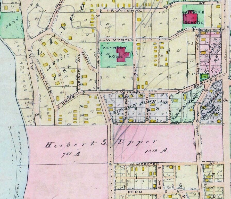
This West Seattle street was created in 1946 by Ordinance 75595 and expanded nearly 40 years later by Ordinance 112188. However, it was named after an earlier Parshall Place, created in 1909 as part of the Replat of Blocks 2, 5, and 6, Lincoln Beach Park. That street is now the north 215 feet of Glenridge Way SW between SW Othello Street and Gatewood Road SW. The “new” Parshall Place begins 1,000 feet due north of SW Othello Street, at SW Frontenac Street.
The two men who notarized the signatures of the men and women executing the plat were Willard C. Haring and L.A. Parshall. I take it this is the same Parshall as in L.A. Parshall & Co., which sold real estate from offices at 318 Colman Building. Louis Ayers Parshall was born in 1870 and died in 1950. His wife, Martha Ida Funk (1871–1964), was the niece of Isaac Kaufmann Funk (1839–1912), co-founder of Funk & Wagnalls, the reference book publisher.
As noted, Parshall Place SW begins at SW Frontenac Street and goes around 860 feet north to SW Holly Street, its middle third being a footpath connecting the two alley-like segments.
Real estate ad by L.A. Parshall & Co. on page 57 of the April 14, 1907, issue of The Seattle Times. I’m not sure which corner(s) of 6th Avenue and Spring Street were for sale, but today Interstate 5 and Freeway Park take up the northeast and southeast corners. Parshall Place SW, meanwhile, is a block east of California Avenue SW.
Born and raised in Seattle, Benjamin Donguk Lukoff had his interest in local history kindled at the age of six, when his father bought him settler granddaughter Sophie Frye Bass’s Pig-Tail Days in Old Seattle at the gift shop of the Museum of History and Industry. He studied English, Russian, and linguistics at the University of Washington, and went on to earn his master’s in English linguistics from University College London. His book of rephotography, Seattle Then and Now, was published in 2010. An updated version came out in 2015.
Only a few years after the bill’s 1902 passage, however, Maxwell became a staunch critic of its Bureau of Reclamation, which, much to his chagrin, rapidly devolved from a “welfare agency” to a “construction agency,” for which building dams, rather than reaping social benefits, became the ultimate goal. Agribusinessmen, land developers, and municipal leaders who had little interest in or stomach for Edenic visions of family-farm communities increasingly manipulated the region’s water resources. Maxwell became obsessed with the thought that these hydraulic projects deprioritized the needs of the urban poor.
He therefore formed the American Homecroft Society in 1907, which “aimed to reclaim small vacant lots and back alleys rather than millions of acres of arid lands. It encouraged wageworkers to become competent backyard gardeners rather than yeoman farmers.”
Maxwell proffered homecrofts as the antidote to major crises confronting urban America. In addition to mending industrial workers’ severed relationship with nature, homes that incorporated spaces for production, to Maxwell’s mind, granted working-class families autonomy and supplemental income in a volatile market. They stymied a mass market bent on transforming suburban homes into shallow spaces of conspicuous consumption.
Homecroft advertisement, The Seattle Times, June 20, 1920, page 11
However, as this 1936 aerial photo of the area shows, most of the land remained vacant. (For reference, the two prominent north–south streets are 21st and 16th Avenues SW; the long diagonal at left is Croft Place SW; and the diagonal in the southwest corner is Delridge Way SW [originally McKinnon Way SW].) I’m sure the Great Depression did not help matters. In addition, the Puget Creek Greenspace occupies much of the land between 18th and 21st Avenues SW. Today, the entire neighborhood is residential, with nary a farm in sight, if indeed any were ever built.
Croft Place SW exists in two segments. One runs ¼ of a mile southeast from the intersection of SW Juneau Street and 23rd Avenue SW, just north of the Louisa Boren STEM K-8 School campus, to 21st Avenue SW just north of its intersection with SW Graham Street. The other is essentially a driveway that runs around 175 feet northeast from Delridge Way SW between SW Myrtle Street and SW Willow Street, although the undeveloped right-of-way extends 625 feet further, to the intersection of SW Holly Street and 21st Avenue SW.
Homecroft advertisement, The Seattle Times, June 17, 1920, page 15. See the full PDF.
Born and raised in Seattle, Benjamin Donguk Lukoff had his interest in local history kindled at the age of six, when his father bought him settler granddaughter Sophie Frye Bass’s Pig-Tail Days in Old Seattle at the gift shop of the Museum of History and Industry. He studied English, Russian, and linguistics at the University of Washington, and went on to earn his master’s in English linguistics from University College London. His book of rephotography, Seattle Then and Now, was published in 2010. An updated version came out in 2015.
This street was named in 1906 as Raymond Avenue, part of Replat Tracts 30 & 31 Sunnyside 5 Acre Tracts, by Herbert R. Raymond (1862–1933) of New Brunswick, Canada, and his wife, Minnie M. Raymond (1874–1947), née Truax, of Massachusetts. In 1907, it and Spencer Avenue became Raymond Street as part of the renaming of streets in Beacon Hill and Rainier Valley, and Grand Avenue, Grand View Avenue, and Sixteenth Street in West Seattle took the name as well. Three years later, when Georgetown was annexed, Raymond Street replaced James Street. (All this information from Rob Ketcherside’s extremely useful searchable table of street name changes.)
Herbert came to Washington as a child, along with his family; Minnie appears to have come later, and the two married in 1895. His eldest brother, George (Herbert was the youngest of eight children), sold shoes in Seattle and was also on the city council and in the territorial, as it then was, legislature. He later moved to Bellingham and was on the city council there in 1912 and 1913, and was mayor for less than two months, in December 1915 and January 1916, his term ending with his sudden death.
Herbert himself was also in the shoe business. As his Seattle Times obituary put it, he was:
Formerly one of the Pacific Northwest’s prominent shoe merchants and leading civic spirits… He had been retired for the past twelve years and had spent most of his time out of doors improving his two-acre residential property which overlooks Lake Washington. Mr. Raymond came to Seattle four years before the Seattle fire and helped fight it. His first shoe store was at First Avenue near Madison Street. He operated in other locations and under other firm names in subsequent years.
Article in the May 7, 1922, Seattle Times, about deer grazing on Herbert Raymond’s lawn and in his orchard. “I believe they came originally from Mercer Island, swimming across to Seward Park. There are no dogs about and the tempting green stuff in my garden coaxed them over the fence…. I don’t see a chance to grow a garden. But the deer are worth it. Their beauty more than repays for their feed.” Download the article as a PDF.
S Raymond Street begins at 51st Place S and goes just over ⅕ of a mile west to 48th Avenue S. It resumes at 44th Avenue S and goes a block west to 42nd Avenue S. There is another short segment that goes 1½ blocks west from Martin Luther King Jr. Way S, and then a longer segment begins at 33rd Avenue S and goes ½ a mile west to Beacon Avenue S, the portion crossing the Chief Sealth Trail being a pathway. A few more segments appear between 24th Avenue S and Swift Avenue S.
SW Raymond Street begins in West Seattle at High Point Drive SW and SW Graham Street and goes 1¼ miles west to 49th Avenue SW.
Born and raised in Seattle, Benjamin Donguk Lukoff had his interest in local history kindled at the age of six, when his father bought him settler granddaughter Sophie Frye Bass’s Pig-Tail Days in Old Seattle at the gift shop of the Museum of History and Industry. He studied English, Russian, and linguistics at the University of Washington, and went on to earn his master’s in English linguistics from University College London. His book of rephotography, Seattle Then and Now, was published in 2010. An updated version came out in 2015.
Born and raised in Seattle, Benjamin Donguk Lukoff had his interest in local history kindled at the age of six, when his father bought him settler granddaughter Sophie Frye Bass’s Pig-Tail Days in Old Seattle at the gift shop of the Museum of History and Industry. He studied English, Russian, and linguistics at the University of Washington, and went on to earn his master’s in English linguistics from University College London. His book of rephotography, Seattle Then and Now, was published in 2010. An updated version came out in 2015.
Born and raised in Seattle, Benjamin Donguk Lukoff had his interest in local history kindled at the age of six, when his father bought him settler granddaughter Sophie Frye Bass’s Pig-Tail Days in Old Seattle at the gift shop of the Museum of History and Industry. He studied English, Russian, and linguistics at the University of Washington, and went on to earn his master’s in English linguistics from University College London. His book of rephotography, Seattle Then and Now, was published in 2010. An updated version came out in 2015.
Gatewood Road SW begins at Glenridge Way SW south of SW Othello Street and goes around 850 feet southeast to 40th Avenue SW north of SW Webster Street.
Obituary of Carlisle Gatewood, from the May 30, 1947, issue of The Seattle Times
Born and raised in Seattle, Benjamin Donguk Lukoff had his interest in local history kindled at the age of six, when his father bought him settler granddaughter Sophie Frye Bass’s Pig-Tail Days in Old Seattle at the gift shop of the Museum of History and Industry. He studied English, Russian, and linguistics at the University of Washington, and went on to earn his master’s in English linguistics from University College London. His book of rephotography, Seattle Then and Now, was published in 2010. An updated version came out in 2015.
This street was created in 1906 as part of the plat of Seaside Addition, a Replat of Part of Lot 2, Alki Point, filed by William Holt (who was, among other things, proprietor of the Grand Central Hotel in Pioneer Square). He passed away nine years later, as noted in this story from the front page of the November 18, 1915, issue of The Seattle Star. Running just over 450 feet south from Alki Avenue SW to SW Lander Street, between 58th and 59th Avenues SW, it would seem to be a reasonable assumption that it was so named for its close proximity to the waterfront.
Born and raised in Seattle, Benjamin Donguk Lukoff had his interest in local history kindled at the age of six, when his father bought him settler granddaughter Sophie Frye Bass’s Pig-Tail Days in Old Seattle at the gift shop of the Museum of History and Industry. He studied English, Russian, and linguistics at the University of Washington, and went on to earn his master’s in English linguistics from University College London. His book of rephotography, Seattle Then and Now, was published in 2010. An updated version came out in 2015.
This West Seattle street was created as part of the plat of Woodside, an Addition to the City of Seattle, filed on June 17, 1919, by Eugene E. Harold, and named for the subdivision. I don’t think it’s too much of a stretch to assume the subdivision was so named because of its proximity to the wooded area that is now Lincoln Park.
Woodside Place SW begins at SW Myrtle Street just south of Gatewood Elementary School and goes just over 600 feet south to SW Othello Street.
Detail of 1912 Baist atlas of Seattle showing current location of Woodside Place, south of W Myrtle Street (now SW Myrtle Street) just southwest of Gatewood Elementary School. The vacant land shaded in pink as and noted as belonging to Herbert S. Upper is now part of Lincoln Park (along Puget Sound) and Solstice Park, formerly Lincoln Park Annex (to the east, between what are now Fauntleroy Way SW and 44th Avenue SW).
Born and raised in Seattle, Benjamin Donguk Lukoff had his interest in local history kindled at the age of six, when his father bought him settler granddaughter Sophie Frye Bass’s Pig-Tail Days in Old Seattle at the gift shop of the Museum of History and Industry. He studied English, Russian, and linguistics at the University of Washington, and went on to earn his master’s in English linguistics from University College London. His book of rephotography, Seattle Then and Now, was published in 2010. An updated version came out in 2015.
As part of the Great Renaming of 1895, Texas Street, Town Street, Fontenelle Street, Flemming Street, Davidson Street, and Canal Street became Atlantic Street, from Elliott Bay to Lake Washington. The name was extended into West Seattle in 1907, when Grant Street and Louisiana Street were combined.
Today, SW Atlantic Street begins in West Seattle at Sunset Avenue SW and goes ¼ of a mile east to Palm Avenue SW. It next appears, as S Atlantic Street, just east of U.S. Coast Guard Base Seattle at Alaskan Way S, and goes around 800 feet east to 1st Avenue S, where it becomes Edgar Martinez Drive S (renamed in honor of the ball player in 2004). Apart from a stub east of Airport Way S that is soon blocked by Interstate 5, the street’s next appearance is on Beacon Hill, where it goes ⅓ of a mile from just west of 11th Avenue S to 17th Avenue S, the portion between 15th Avenue S and 16th Avenue S being a stairway.
After being interrupted for a number of blocks by Interstate 90, S Atlantic Street reappears at 21st Avenue S and goes a block to just east of 22nd Avenue S. (Here, it gives its name to the surrounding Atlantic neighborhood.) It resumes — again having been interrupted by Interstate 90’s Mount Baker Tunnel — at Bradner Place S and goes ⅓ of a mile east to Lake Washington Boulevard S, the portions between 30th Avenue S and 31st Avenue South as well as between 32nd Avenue S and 33rd Avenue S being stairways. The right-of-way begins again at 35th Avenue S and goes around ⅛ of a mile east to Lake Washington, but is either incorporated into adjacent homeowners’ yards or serves as their driveways for most of this distance. Between Lakeside Avenue S and the water, it is one of the city’s shoreline street ends.
Born and raised in Seattle, Benjamin Donguk Lukoff had his interest in local history kindled at the age of six, when his father bought him settler granddaughter Sophie Frye Bass’s Pig-Tail Days in Old Seattle at the gift shop of the Museum of History and Industry. He studied English, Russian, and linguistics at the University of Washington, and went on to earn his master’s in English linguistics from University College London. His book of rephotography, Seattle Then and Now, was published in 2010. An updated version came out in 2015.
SW Massachusetts Street begins in West Seattle at the intersection of Bonair Drive SW, 47th Avenue SW, and Sunset Avenue SW, and goes just under ⅓ of a mile east to Palm Avenue SW. It begins again at Ferry Avenue SW and goes just over 450 feet east to Victoria Avenue SW. There is a short segment (just over 400 feet) on Harbor Island east of 13th Avenue SW, and then another one, about the same length, leading from Alaskan Way S to the entrance to U.S. Coast Guard Base Seattle. (Here, the street’s directional designation has changed to S, it being east of the Duwamish Waterway.)
S Massachusetts Street resumes at Colorado Avenue S and goes ⅙ of a mile east to Occidental Avenue S. There is a block-long segment east of 4th Avenue S to just shy of the SODO Busway, and then a longer one — about ¼ of a mile — from the SODO Trail to Airport Avenue S.
East of Interstate 5, on Beacon Hill, S Massachusetts Street begins at 11th Avenue S and goes nearly ¼ of a mile east to just past 15th Avenue S, the portion between 14th Avenue S and 15th Avenue S being pedestrian-only, as the right-of-way between the sidewalks has been turned into the Beacon Bluff P-Patch community garden. It begins again just west of Sturgus Avenue S and goes nearly a mile east to just past 31st Avenue S, the portion that runs for half a block west of 17th Avenue S being a pathway. S Massachusetts Street resumes for the last time at 32nd Avenue S and goes ¼ mile east to Lake Washington, where it is a shoreline street end.
Born and raised in Seattle, Benjamin Donguk Lukoff had his interest in local history kindled at the age of six, when his father bought him settler granddaughter Sophie Frye Bass’s Pig-Tail Days in Old Seattle at the gift shop of the Museum of History and Industry. He studied English, Russian, and linguistics at the University of Washington, and went on to earn his master’s in English linguistics from University College London. His book of rephotography, Seattle Then and Now, was published in 2010. An updated version came out in 2015.
This street received its name in 1907, uniting streets formerly known as Nebraska Street, 8th Street, Bedford Street, Conover Street, and G Street. (There had been an Oregon Street in the 1895 Seattle Tide Lands plat in which Nebraska Street was created, but it became Spokane Street and Chelan Avenue in the same 1907 change.)
S Oregon Street begins in West Seattle as SW Oregon Street at the Emma Schmitz Memorial Overlook on Beach Drive SW and goes two blocks east to Me-Kwa-Mooks Park at 56th Avenue SW. It briefly resumes at 52nd Avenue SW and goes two blocks east to 51st Avenue SW, then begins again in earnest at 50th Avenue SW, going nearly a mile east to the West Seattle Stadium at 35th Avenue SW, part of the stretch between there and Fauntleroy Way SW being footpath and stairway. East of the West Seattle Golf Course, it goes around 175 feet to 26th Avenue SW and the Delridge Playfield, and on the other side of the playfield serves as a short connector between Delridge Way SW and 23rd Avenue SW.
S Oregon Street resumes east of the Duwamish Waterway at a shoreline street end and goes ¼ mile east to E Marginal Way S. It then serves as short connectors between Diagonal Avenue S and Denver Avenue S and between 7th Avenue S and Airport Way S.
East of Interstate 5, on Beacon Hill, S Oregon Street begins again at 10th Avenue S and goes ⅓ of a mile east to 15th Avenue S and S Columbian Way. It picks up again in the Rainier Valley at S Columbian Way and Martin Luther King Jr. Way S and goes ⅔ of a mile east to Genesee Park at 42nd Avenue S. East of the park, it resumes at 47th Avenue S and goes ¼ mile east to its end at 52nd Avenue S above the Lakewood Marina on Lake Washington.
Born and raised in Seattle, Benjamin Donguk Lukoff had his interest in local history kindled at the age of six, when his father bought him settler granddaughter Sophie Frye Bass’s Pig-Tail Days in Old Seattle at the gift shop of the Museum of History and Industry. He studied English, Russian, and linguistics at the University of Washington, and went on to earn his master’s in English linguistics from University College London. His book of rephotography, Seattle Then and Now, was published in 2010. An updated version came out in 2015.
Article listing South Seattle street name changes in January 14, 1906, issue of the Seattle Post-Intelligencer
SW Nevada Street begins in West Seattle at 30th Avenue SW and goes ¼ mile east to 26th Avenue SW. It next appears east of the Duwamish Waterway in the Industrial District, as a ¼-mile-long service road off E Marginal Way S and a 300-foot-long dead-end road off 6th Avenue S. East of Interstate 5 on Beacon Hill, it goes ¼ mile east from 11th Avenue S to 16th Avenue S at Jefferson Park. It resumes for the last time in Rainier Valley at 28th Avenue S and S Adams Street and goes ¼ mile east to 31st Avenue S.
Born and raised in Seattle, Benjamin Donguk Lukoff had his interest in local history kindled at the age of six, when his father bought him settler granddaughter Sophie Frye Bass’s Pig-Tail Days in Old Seattle at the gift shop of the Museum of History and Industry. He studied English, Russian, and linguistics at the University of Washington, and went on to earn his master’s in English linguistics from University College London. His book of rephotography, Seattle Then and Now, was published in 2010. An updated version came out in 2015.
Streets in this plat that were not extensions of already existing ones, such as Commercial Street, were named after letters of the alphabet, American cities, American states, prominent local politicians, and places in Washington.… the states appear neither in alphabetical nor geographic order.
In this case, of course, the street was named for the Dakotas, not for South Dakota.
SW Dakota Street begins at 56th Avenue SW and goes 1⅓ miles east to 34th Avenue SW. It resumes at 30th Avenue SW and goes a further ⅓ of a mile east to Delridge Way SW, the portion between 28th Avenue SW and 26th Avenue SW being footpaths through the Longfellow Creek Natural Area park. SW Dakota Street begins again just west of 21st Avenue SW and goes just over 750 feet east to 19th Avenue SW, and there is one final segment west of the Duwamish Waterway between 16th Avenue SW and W Marginal Way SW.
East of the Duwamish, S Dakota Street runs for a block between 1st Avenue S and 2nd Avenue S, then picks up again at 6th Avenue S and goes ¼ mile east to 9th Avenue S. East of Interstate 5 on Beacon Hill, S Dakota Street resumes at 12th Avenue S and goes another ¼ mile east to Jefferson Park at 16th Avenue S. It begins again in the Rainier Valley at 29th Avenue S and goes ⅓ of a mile east to 34th Avenue S, picking up again at Rainier Avenue S and going ⅖ of a mile east to Genesee Park at 43rd Avenue S. On the other side of the park, it resumes at 46th Avenue S and goes ⅓ of a mile east to its end at 51st Avenue S, overlooking Lake Washington.
Born and raised in Seattle, Benjamin Donguk Lukoff had his interest in local history kindled at the age of six, when his father bought him settler granddaughter Sophie Frye Bass’s Pig-Tail Days in Old Seattle at the gift shop of the Museum of History and Industry. He studied English, Russian, and linguistics at the University of Washington, and went on to earn his master’s in English linguistics from University College London. His book of rephotography, Seattle Then and Now, was published in 2010. An updated version came out in 2015.
This street was created in 1895 as part of the plat of Seattle’s tide lands, which featured streets named for letters of the alphabet, American cities, American states, prominent local politicians, and places in Washington. Among the latter were S Spokane Street, Duwamish Avenue S, Klickitat Avenue SW, and our current subject, Chelan Avenue SW. It appears to have been named for Lake Chelan (an anglicization of ščəl̕ámxəxʷ, meaning ‘deep water’ in Nxaʔamxcín, the language spoken by the Chelan people) — the largest natural lake in Washington and the third deepest lake in the United States (after Crater and Tahoe).
Chelan Avenue SW begins at SW Spokane Street and goes ¼ mile northwest to the West Duwamish Waterway.
Born and raised in Seattle, Benjamin Donguk Lukoff had his interest in local history kindled at the age of six, when his father bought him settler granddaughter Sophie Frye Bass’s Pig-Tail Days in Old Seattle at the gift shop of the Museum of History and Industry. He studied English, Russian, and linguistics at the University of Washington, and went on to earn his master’s in English linguistics from University College London. His book of rephotography, Seattle Then and Now, was published in 2010. An updated version came out in 2015.
Streets in this plat that were not extensions of already existing ones, such as Commercial Street, were named after letters of the alphabet, American cities, American states, prominent local politicians, and places in Washington.… the states appear neither in alphabetical nor geographic order.
SW Florida Street begins on Harbor Island at 11th Avenue SW and goes ¼ mile southwest to 16th Avenue SW. The right-of-way continues for another ⅖ of a mile through Terminal 5 in West Seattle, though only a small portion (beginning at Harbor Avenue SW and going about 700 feet northeast) corresponds with an actual roadway.
Born and raised in Seattle, Benjamin Donguk Lukoff had his interest in local history kindled at the age of six, when his father bought him settler granddaughter Sophie Frye Bass’s Pig-Tail Days in Old Seattle at the gift shop of the Museum of History and Industry. He studied English, Russian, and linguistics at the University of Washington, and went on to earn his master’s in English linguistics from University College London. His book of rephotography, Seattle Then and Now, was published in 2010. An updated version came out in 2015.
This street was created in 1891 as part of the plat of Columbia, which incorporated in 1893 and was annexed to Seattle in 1907, becoming the neighborhood of Columbia City. Part of a series of streets named after explorers — (Christopher) Columbus Street (subsequently changed to Edmunds Street), Ferdinand (Magellan) Street, and Americus (Vespucci) Street — it was named for English explorer Henry Hudson (c. 1565–disappeared 1611), namesake of Hudson Bay in Canada and the Hudson River in New York and New Jersey.
After a false start as a dead-end road west of 57th Avenue S, S Hudson Street begins at 53rd Avenue S and goes ⅓ of a mile west to 47th Avenue S, becoming a stairway between 50th Avenue S and 49th Avenue S. It resumes at 46th Avenue S and goes ¾ of a mile west to Martin Luther King Jr. Way S. After another couple of short segments, it begins again at 28th Avenue S and goes ¼ mile west to 24th Avenue S. There are two more short segments on Beacon Hill, and then Hudson Street resumes in Georgetown, going ⅖ of a mile from 4th Avenue S to E Marginal Way S.
In West Seattle, SW Hudson Street begins as a service road and footpath within Puget Park off 18th Avenue SW. Its first appearance as a residential street is at Puget Boulevard SW, where it goes ⅕ of a mile to the West Seattle Golf Course. It then picks up again at 35th Avenue SW, where it goes just over a mile to SW Jacobsen Road, becoming a stairway three separate times along the way.
Born and raised in Seattle, Benjamin Donguk Lukoff had his interest in local history kindled at the age of six, when his father bought him settler granddaughter Sophie Frye Bass’s Pig-Tail Days in Old Seattle at the gift shop of the Museum of History and Industry. He studied English, Russian, and linguistics at the University of Washington, and went on to earn his master’s in English linguistics from University College London. His book of rephotography, Seattle Then and Now, was published in 2010. An updated version came out in 2015.


