Born and raised in Seattle, Benjamin Donguk Lukoff had his interest in local history kindled at the age of six, when his father bought him settler granddaughter Sophie Frye Bass’s Pig-Tail Days in Old Seattle at the gift shop of the Museum of History and Industry. He studied English, Russian, and linguistics at the University of Washington, and went on to earn his master’s in English linguistics from University College London. His book of rephotography, Seattle Then and Now, was published in 2010. An updated version came out in 2015.
Born and raised in Seattle, Benjamin Donguk Lukoff had his interest in local history kindled at the age of six, when his father bought him settler granddaughter Sophie Frye Bass’s Pig-Tail Days in Old Seattle at the gift shop of the Museum of History and Industry. He studied English, Russian, and linguistics at the University of Washington, and went on to earn his master’s in English linguistics from University College London. His book of rephotography, Seattle Then and Now, was published in 2010. An updated version came out in 2015.
Born and raised in Seattle, Benjamin Donguk Lukoff had his interest in local history kindled at the age of six, when his father bought him settler granddaughter Sophie Frye Bass’s Pig-Tail Days in Old Seattle at the gift shop of the Museum of History and Industry. He studied English, Russian, and linguistics at the University of Washington, and went on to earn his master’s in English linguistics from University College London. His book of rephotography, Seattle Then and Now, was published in 2010. An updated version came out in 2015.
This street was created as part of the 1889 plat of West Seattle Park and named after West Seattle developer and Seattle city councilman Uriah Roush Niesz (1849–1929). According to Images of America: West Seattle,
…In what is now the Admiral District, the now familiar moniker “West Seattle” was first used by Uriah Niesz when developing five-acre homesites in 1885.
[He took] a prominent part in the replatting and upbuilding of the city. He with other members of the council had mapped out the whole plan some time previous to the fire, which made it possible to accomplish their purpose.… As a member of the council Mr. Niesz was made chairman of the judiciary, finance and harbor and wharves committees and the last named took up the whole burden of replatting the business and shipping section of the city.… Herculean as was the task of this committee in bringing order out of chaos in this part of the city; in opening the way for land and water traffic to meet at a minimum cost of transshipment; in providing facilities for a marvelous growth in the business of a future great city; in short in giving the city a new birth, yet this great task paled into insignificance compared with the responsibilities resting upon the finance committee, of which Mr. Niesz was also chairman.
I find that contemporary biographies of pioneers tend to read like hagiographies, but in this case I think Niesz’s entire biography is worth a read.
At left, Niesz as part of a portrait of Seattle’s mayor and city councilmen for 1888–1890. At right, the photograph accompanying his obituary in the Seattle Post-Intelligencer issue of September 22, 1929.
SW Niesz Court begins at 50th Avenue SW just south of the College Street Ravine and goes two blocks east to 48th Avenue SW.
Born and raised in Seattle, Benjamin Donguk Lukoff had his interest in local history kindled at the age of six, when his father bought him settler granddaughter Sophie Frye Bass’s Pig-Tail Days in Old Seattle at the gift shop of the Museum of History and Industry. He studied English, Russian, and linguistics at the University of Washington, and went on to earn his master’s in English linguistics from University College London. His book of rephotography, Seattle Then and Now, was published in 2010. An updated version came out in 2015.
In History of Seattle from the Earliest Settlement to the Present Time, Clarence Bagley writes that Benton, who was born in Iowa and came to Seattle in 1890 from Montana,
…spent many years with different railroad companies. For a time he was connected with the Great Northern and later he became general passenger and freight agent for the Chicago, Burlington & Quincy Railroad at Seattle. The last few years of his life were spent in connection with the safe and lock trade. He was associated with the Norris Safe & Lock Company… Later Mr. Norris took over the safe and lock company and Mr. Benton the desk department of the business, after which he was joined by Edward Herald in a partnership that was continued under the name of the Benton-Herald Desk & Safe Company until [his death].
Born and raised in Seattle, Benjamin Donguk Lukoff had his interest in local history kindled at the age of six, when his father bought him settler granddaughter Sophie Frye Bass’s Pig-Tail Days in Old Seattle at the gift shop of the Museum of History and Industry. He studied English, Russian, and linguistics at the University of Washington, and went on to earn his master’s in English linguistics from University College London. His book of rephotography, Seattle Then and Now, was published in 2010. An updated version came out in 2015.
SW Teig Place begins at 57th Avenue SW just north of SW Stevens Street and goes around 450 feet northeast to 56th Avenue SW just north of SW Lander Place.
Born and raised in Seattle, Benjamin Donguk Lukoff had his interest in local history kindled at the age of six, when his father bought him settler granddaughter Sophie Frye Bass’s Pig-Tail Days in Old Seattle at the gift shop of the Museum of History and Industry. He studied English, Russian, and linguistics at the University of Washington, and went on to earn his master’s in English linguistics from University College London. His book of rephotography, Seattle Then and Now, was published in 2010. An updated version came out in 2015.
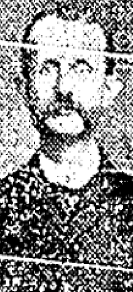
As Phillip H. Hoffman, director of the Alki History Project, tells us in his article “What’s in a Name?,” this street was named after Benjamin Wilton Baker (1860–1934), husband of Julia Curry Williams (1861–1950) and father of Marguerite Baker (1890–?), after whom SW Marguerite Court is named. The Bakers were proprietors of Rose Lodge, a summer resort which once stood where the eastern portion of SW Wilton Court is now.
Benjamin Wilton Baker, from the November 30, 1901, issue of The Seattle Times
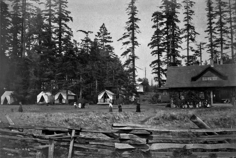
Rose Lodge and tents from beach, 1913
SW Wilton Court begins at SW Hinds Street across the street from the Bar-S Playground, and goes just over 700 feet southeast to 63rd Avenue SW between Beach Drive SW and SW Marguerite Court. It is a private right-of-way between 64th Avenue SW and 63rd Avenue SW.
Born and raised in Seattle, Benjamin Donguk Lukoff had his interest in local history kindled at the age of six, when his father bought him settler granddaughter Sophie Frye Bass’s Pig-Tail Days in Old Seattle at the gift shop of the Museum of History and Industry. He studied English, Russian, and linguistics at the University of Washington, and went on to earn his master’s in English linguistics from University College London. His book of rephotography, Seattle Then and Now, was published in 2010. An updated version came out in 2015.
This street, which is part of the unrecorded plat of B.W. Baker’s Rose Lodge Addition, was named after Marguerite Baker (1890–?), eldest daughter of Benjamin Wilton Baker (1860–1934) and Julia Curry Williams (1861–1950). The Bakers were proprietors of Rose Lodge, a summer resort which once stood where the subdivision is now.
The public right-of-way is a footpath that runs just over 300 feet from 63rd Avenue SW in the southeast to 64th Avenue SW in the northwest. Vehicular access to the homes is from a public alley to the north and a private one to the south.
Born and raised in Seattle, Benjamin Donguk Lukoff had his interest in local history kindled at the age of six, when his father bought him settler granddaughter Sophie Frye Bass’s Pig-Tail Days in Old Seattle at the gift shop of the Museum of History and Industry. He studied English, Russian, and linguistics at the University of Washington, and went on to earn his master’s in English linguistics from University College London. His book of rephotography, Seattle Then and Now, was published in 2010. An updated version came out in 2015.
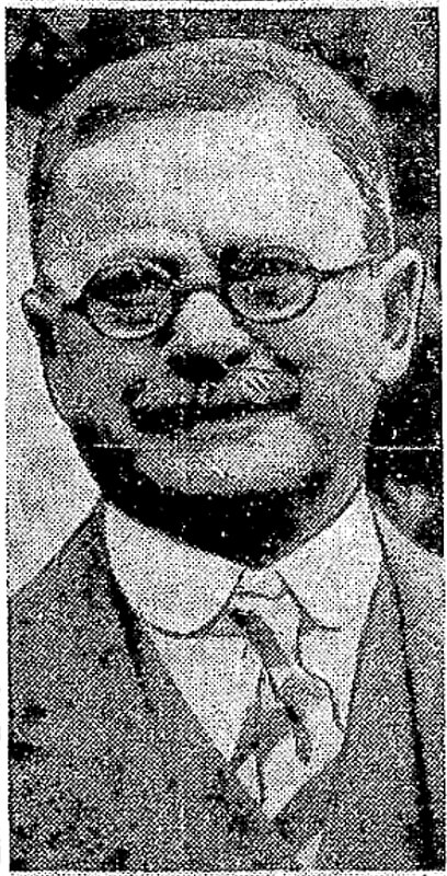
W.T. Campbell was a long-time West Seattle resident living on the hillside above Alki. He was an early advocate for Alki annexation to the City of West Seattle, a real estate developer, early West Seattle school principal, banker, and a member of the Seattle City Council beginning 1924. He would serve as a city councilmember until 1929.
W.T. Campbell, from the October 11, 1933, issue of The Seattle Times
SW Campbell Place begins at SW Lander Street a block west of SW Admiral Way and goes just over 550 feet southwest to 56th Avenue SW at the north edge of Schmitz Park.
Born and raised in Seattle, Benjamin Donguk Lukoff had his interest in local history kindled at the age of six, when his father bought him settler granddaughter Sophie Frye Bass’s Pig-Tail Days in Old Seattle at the gift shop of the Museum of History and Industry. He studied English, Russian, and linguistics at the University of Washington, and went on to earn his master’s in English linguistics from University College London. His book of rephotography, Seattle Then and Now, was published in 2010. An updated version came out in 2015.
I first came across the Alki History Project while doing research for my article on SW Bronson Way. I’m not sure how I missed it before. The paper that mentioned Ira Bronson was “If at First You Don’t Succeed…,” a fascinating history of municipal governance and elections in West Seattle, and when I looked at their list of other papers I was thrilled to see among them “What’s in a Name?” — an investigation of Alki street names, both current and those changed long ago. Frater Avenue SW is the first of a number of posts in which I will be citing this paper, written by Phillip H. Hoffman, director of the project.
Frater Avenue SW originates in the 1955 plat of Anderson’s Soundview Terrace Addition № 2. Why Anderson, Caple, or Knowlton weren’t chosen instead for the honor (this being the only new street in the small subdivision, and those being the surnames of the three couples who filed the plat) isn’t clear. But, as Hoffman notes, SW Frater Street and SW Frater Place (both of which have since been vacated) were just to the west in the adjacent plat. In addition, an earlier Frater Avenue SW had existed, until it was vacated in 1942, just southeast of where today’s Frater Avenue begins at SW Spokane Street. The current Frater Avenue must have been named after one of these three streets.
But, of course, that leaves the question of who those three streets initially honored, and according to Hoffman,
Frater Avenue first appears in the plat Partition of Crawford Tract as ordered in King County Superior Court, Cause № 64110, June 17, 1915. [A.W.] Frater was the presiding judge.… The court commissioners assisting in the adjudication of a land title and ownership dispute before Judge Frater that resulted in the Crawford Tract plat probably named Frater Avenue in 1915, along with all the other streets appearing in the plat.
Archibald Wanless Frater (1856–1925), according to Cornelius Holgate in Seattle and Environs, was born in Ohio and came to Washington in 1888. Initially settling in Tacoma, he moved to Snohomish the next year and came to Seattle in 1898.
Judge Archibald Wanless Frater, from the front cover of The Seattle Mail & Herald, June 3, 1905
Today’s Frater Avenue SW begins at 57th Avenue SW just north of SW Hinds Street and goes ⅛ of a mile southeast to SW Spokane Street just west of 56th Avenue SW.
Born and raised in Seattle, Benjamin Donguk Lukoff had his interest in local history kindled at the age of six, when his father bought him settler granddaughter Sophie Frye Bass’s Pig-Tail Days in Old Seattle at the gift shop of the Museum of History and Industry. He studied English, Russian, and linguistics at the University of Washington, and went on to earn his master’s in English linguistics from University College London. His book of rephotography, Seattle Then and Now, was published in 2010. An updated version came out in 2015.
This West Seattle street was created in 1900 as part of the Replat of the West Seattle Land & Improvement Co’s. Third Plat. Originally Beach Way, it was renamed Bronson Way in 1907, when Seattle annexed West Seattle. Given that Ira Hull Bronson (1868–1930) was attorney for and vice president of the WSL&IC, it seems a fair assumption that it was named for him.
Ira Bronson, from his June 17, 1930, obituary in The Seattle Times. He had died the day before.
Bronson, a former president of the American Bar Association, was described in the June 18, 1930, issue of The Seattle Times as a “pioneer Seattle attorney and leader in admiralty circles… [who] was one of the founders of the Inland Navigation Company, which later became the Puget Sound Navigation Company.” (The PSNC’s domestic ferry routes were bought by the state in 1951, forming Washington State Ferries, and most of its Canadian routes became part of the new BC Ferries system in 1961. The firm, now known as the Black Ball Ferry Line, now runs one boat, the MV Coho, between Port Angeles and Victoria. Through a series of mergers, Bronson’s law firm is now Stoel Rives.)
Though the right-of-way begins further inland, SW Bronson Way only physically exists between Harbor Avenue SW and Elliott Bay. About 180 feet long, it is nearly 90 feet wide (quite a length-to-width ratio!) and essentially serves as a public parking lot. It is a shoreline street end, platted into the water, and features an unobstructed view of the city across the bay.
Born and raised in Seattle, Benjamin Donguk Lukoff had his interest in local history kindled at the age of six, when his father bought him settler granddaughter Sophie Frye Bass’s Pig-Tail Days in Old Seattle at the gift shop of the Museum of History and Industry. He studied English, Russian, and linguistics at the University of Washington, and went on to earn his master’s in English linguistics from University College London. His book of rephotography, Seattle Then and Now, was published in 2010. An updated version came out in 2015.
Originally Ravenna Avenue in the 1890 plat of the Woodlawn Addition to Green Lake, Weedin Place NE was named for the Weedin brothers, early settlers of the area. (Weedin’s Homestead Addition to the City of Seattle, filed by Robert Weedin, his son, and their wives in 1904, lies to the south; it would seem that when Ravenna Boulevard NE was established slightly to the west, Ravenna Avenue needed a new name, and that of the Weedins was chosen.)
In the fall of 1879, 10 years after the first homesteader arrived at Green Lake, a newly erected, simple log cabin schoolhouse opened its doors to 11 pupils.… This was the first Green Lake School.… The children came from four households on the east side of the lake: seven were sons and daughters of the brothers W. L. and Robert Weedin.… Thus began public school education in the territorial School District № 25.
And Valarie Bunn tells us on her blog, Wedgwood in Seattle History, that Robert Joseph Weedin (1842–1910) and William Luther Weedin (1845–1930) were Civil War veterans from Missouri who “did not have to take a full five years to ‘prove up a claim’ and be awarded ownership of land, according to the Homestead Act of 1862,” but could count their time in the service toward that total. Robert’s claim, as noted above, was southeast of Green Lake, while William’s was further east, in Wedgwood and Bryant.
A photograph of brothers W.L. and Robert Weedin that ran in the Seattle Post-Intelligencer, May 23, 1965, in an article about early schools in Green Lake
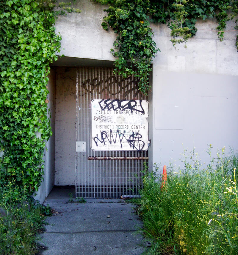
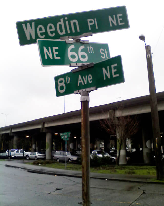
Today, Weedin Place NE begins at 5th Avenue NE and NE 70th Street and goes ¼ of a mile southeast to just past 8th Avenue NE and NE 66th Street, where the right-of-way becomes a park. It is notable for being the location of the Weedin Place fallout shelter, located under Interstate 5. Read more about it in “‘Lifeboat Ethics’ Under the Interstate: Seattle’s Prototype Highway Fallout Shelter,” by Washington State Department of Transportation historian Craig Holstine, who writes that
…The Weedin Place facility was apparently the first, and only, fallout shelter ever constructed in the U.S. under a public roadway. It was built under what would become Interstate 5 at the height of the Cold War in part as a way to demonstrate more effective uses of public rights-of-way.… The Commissioner of Public Roads… proposed putting shelters under the interstates as a way to save costs by combining needs of the national shelter and federal-aid highway programs and provide shelter for the traveling public.
Born and raised in Seattle, Benjamin Donguk Lukoff had his interest in local history kindled at the age of six, when his father bought him settler granddaughter Sophie Frye Bass’s Pig-Tail Days in Old Seattle at the gift shop of the Museum of History and Industry. He studied English, Russian, and linguistics at the University of Washington, and went on to earn his master’s in English linguistics from University College London. His book of rephotography, Seattle Then and Now, was published in 2010. An updated version came out in 2015.
This is the first honorary renaming we‘re covering on Writes of Way. It was named for the former “Mayor of Ballard,” Rob Mattson (1949–2018), the year after his death.
Honorary renamings differ from straight renamings in that:
They are done via resolution rather than ordinance
They do not replace the original street name in official records and addresses
They appear on brown, rather than green, signs
Speaking of signs, there appears to be some variation in their design; compare that of Rob Mattson Way, below, to that of Gerard Schwarz Place.
Rob Mattson Way covers 22nd Avenue NW between NW 56th Street and NW 57th Street.
Born and raised in Seattle, Benjamin Donguk Lukoff had his interest in local history kindled at the age of six, when his father bought him settler granddaughter Sophie Frye Bass’s Pig-Tail Days in Old Seattle at the gift shop of the Museum of History and Industry. He studied English, Russian, and linguistics at the University of Washington, and went on to earn his master’s in English linguistics from University College London. His book of rephotography, Seattle Then and Now, was published in 2010. An updated version came out in 2015.
In 2010, the portion of Airport Way S between 4th Avenue S and 6th Avenue S was renamed Seattle Boulevard S at the request of the adjacent property owners, restoring a name that disappeared from the map in 1931.
There were a series of roads following the semicircular curve of Elliott Bay from Downtown to the Duwamish River before the tideflats were filled in: first Beach Road (or River Road), then the Grant Street Bridge, which in turn became Seattle Boulevard once the fill was complete. Sometime before 1918… the portion of Seattle Boulevard that ran northeast–southwest (the southern third of the semicircle) was renamed Diagonal Avenue. (In 1931, the rest of Seattle Boulevard was renamed Airport Way.)
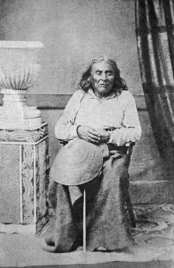
Seattle Boulevard was obviously named for the city, which itself was named after Si’ahl [siʔaɫ], better known in English as Chief Seattle of the Duwamish and Suquamish Tribes.
Since 2010, then, there have been two streets in the city that bear its and siʔaɫ’s name: Seattle Boulevard S and SW Seattle Street.
Born and raised in Seattle, Benjamin Donguk Lukoff had his interest in local history kindled at the age of six, when his father bought him settler granddaughter Sophie Frye Bass’s Pig-Tail Days in Old Seattle at the gift shop of the Museum of History and Industry. He studied English, Russian, and linguistics at the University of Washington, and went on to earn his master’s in English linguistics from University College London. His book of rephotography, Seattle Then and Now, was published in 2010. An updated version came out in 2015.
Today, Bernie Whitebear Way begins at Texas Way and Illinois Avenue and goes ½ a mile northwest, then west, to Daybreak Star.
Bernie Whitebear speaking to Senator Henry M. Jackson during the Daybreak Star lease signing ceremony, November 14, 1971. Courtesy of the Seattle Municipal Archives, Identifier 193058
Born and raised in Seattle, Benjamin Donguk Lukoff had his interest in local history kindled at the age of six, when his father bought him settler granddaughter Sophie Frye Bass’s Pig-Tail Days in Old Seattle at the gift shop of the Museum of History and Industry. He studied English, Russian, and linguistics at the University of Washington, and went on to earn his master’s in English linguistics from University College London. His book of rephotography, Seattle Then and Now, was published in 2010. An updated version came out in 2015.
Born Giovanni Domenicio Corgiat in Italy, John was a real estate investor who, according to his Seattle Times obituary, was also notable for “establish[ing] the Louvre Restaurant, the first French-Italian eating place in Seattle, in 1888.” (It was destroyed the next year in the Great Seattle Fire.) He was also apparently involved in a number of legal cases relating to the explusion of restaurateur John Cicoria from the Joseph Mazzini Society in 1907: not only the lawsuit demanding Cicoria’s reinstatement in the Italian-American fraternal organization, but one in which the society succeeded in making him pay its legal fees, and three libel suits — one which Cicoria won against Corgiat, and two which Corgiat filed against The Seattle Times and the Message-Vero-Italo-Americano with Cicoria as co-defendant in each. The suit against the Times was dismissed at Corgiat’s request; I haven’t been able to find any more information about the other.
John Corgiat, from his obituary in the Seattle Times, December 10, 1936
Originally Corgiat Street, S Corgiat Drive begins at the railroad tracks just east of Airport Way S and goes 300 feet northeast to just past Ursula Place S, at which point it turns northwest and becomes S Corgiat Drive (not in the original plat). From there, it goes ⅖ of a mile to S Albro Place, just west of Interstate 5.
Born and raised in Seattle, Benjamin Donguk Lukoff had his interest in local history kindled at the age of six, when his father bought him settler granddaughter Sophie Frye Bass’s Pig-Tail Days in Old Seattle at the gift shop of the Museum of History and Industry. He studied English, Russian, and linguistics at the University of Washington, and went on to earn his master’s in English linguistics from University College London. His book of rephotography, Seattle Then and Now, was published in 2010. An updated version came out in 2015.
This street, established in 1913 as Sturtevant Place, was named for real estate investor, banker, and antique store owner Cullen Kittredge Sturtevant (1865–1946), who developed a number of tracts in what is now Rainier Beach. Unlike many developers, he didn’t name this street after himself; it was added by the city nearly a decade after he filed Sturtevant’s Plat of Rainier Beach Acre Tracts.
Today, Sturtevant Avenue S begins at Rainier Avenue S between 51st Avenue S and 52nd Avenue S and goes ⅕ of a mile southeast to 52nd Avenue S and S Roxbury Street. Sturtevant Ravine, through which Mapes Creek runs on its way from Kubota Garden to Beer Sheva Park and Lake Washington, lies to its west.
Ad for Sturtevant’s Rainier Beach Lake Front Tracts, The Seattle Times, April 8, 1906
Born and raised in Seattle, Benjamin Donguk Lukoff had his interest in local history kindled at the age of six, when his father bought him settler granddaughter Sophie Frye Bass’s Pig-Tail Days in Old Seattle at the gift shop of the Museum of History and Industry. He studied English, Russian, and linguistics at the University of Washington, and went on to earn his master’s in English linguistics from University College London. His book of rephotography, Seattle Then and Now, was published in 2010. An updated version came out in 2015.
This street was created in 1900 as part of the plat of the Orchard Hill Addition, filed by Martin Dean, Sarah J. Dean, Elizabeth H. Lewis, William H. Lewis, the W.C. Hill Brick Company, and the First National Bank of Seattle. According to Don Sherwood, it was named for John J. Sturgus, “realtor and agent of [the] W.C. Hill Estate” (Hill had died in 1890).
I do find mentions of a John J. Sturgus, associated with the Hill Company or the Hill Estate, in a number of Polk directories. However, it appears a Dr. John J. Sturgus (1859–1907) was also the brother of Hill’s wife, born Alice Bradley Sturgus (1847–1904).
Article in the (Washington, D.C.) Evening Star, September 9, 1890, on the death of W.C. Hill, mentioning Mrs. Hill’s mother (“Mrs. Sturgus”) and brother (Dr. John J. Sturgus).
Given the unlikelihood of two completely different John J. Sturguses being associated with the Hills, I’m going to assume that the physician and real estate man were one and the same, and that the street was given its name either because Dr. Sturgus was Hill’s brother-in-law or because Sturgus was his wife’s maiden name (or both). If the latter, that puts it in the same category as Perkins Lane W, Thorndyke Avenue W, and Keen Way N.
Today, Sturgus Avenue S begins at S Charles Street, just east of the Jose Rizal Bridge, and goes ½ a mile southeast, then south, to S State Street. The right-of-way continues a block further, to the S Grand Street right-of-way, but houses with addresses on that block are accessed by a private alley north of 16th Avenue S.
Born and raised in Seattle, Benjamin Donguk Lukoff had his interest in local history kindled at the age of six, when his father bought him settler granddaughter Sophie Frye Bass’s Pig-Tail Days in Old Seattle at the gift shop of the Museum of History and Industry. He studied English, Russian, and linguistics at the University of Washington, and went on to earn his master’s in English linguistics from University College London. His book of rephotography, Seattle Then and Now, was published in 2010. An updated version came out in 2015.
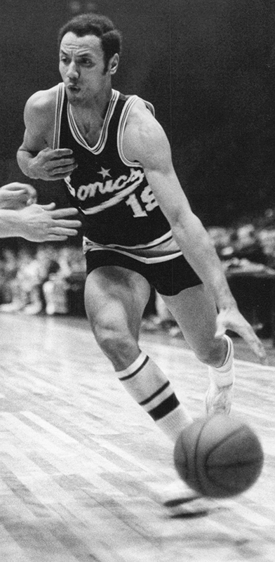
I’m not sure how I missed the news, but in December 2021 the block of Thomas Street between 1st Avenue N and 2nd Avenue N/Seattle Storm Way, just south of Climate Pledge Arena, was officially renamed Lenny Wilkens Way, after the Seattle basketball legend.
Leonard Randolph Wilkens (born 1937), who grew up in Brooklyn, New York, played basketball for the Seattle SuperSonics from 1968–1972, also serving as head coach from 1969–1972. He returned to coach the Sonics in 1977 and stayed until 1986, when he went to the Cleveland Cavaliers. He led the Sonics to two consecutive NBA championship games, in 1978 and 1979, the latter of which the Sonics won, giving Seattle its first national title since the Metropolitans won the Stanley Cup in 1917, and its last until 2004, when the Storm won the WNBA Championship. Wilkens finished his career as head coach of the New York Knicks in 2005. Through the Lenny Wilkens Foundation, which recently wound up operations, he also raised millions of dollars for Seattle Children’s Odessa Brown Children’s Clinic.
As far as I know, and please correct me if I’m wrong, this makes Lenny Wilkens only the second Black person to have a street named after him in Seattle, the first being Martin Luther King Jr.
At left, Lenny Wilkens in 1968; public domain photograph by Malcolm Emmons of The Sporting News. At right, Wilkens in 2013; public domain photograph by Technical Sergeant Samuel Morse, U.S. Air Force.
Born and raised in Seattle, Benjamin Donguk Lukoff had his interest in local history kindled at the age of six, when his father bought him settler granddaughter Sophie Frye Bass’s Pig-Tail Days in Old Seattle at the gift shop of the Museum of History and Industry. He studied English, Russian, and linguistics at the University of Washington, and went on to earn his master’s in English linguistics from University College London. His book of rephotography, Seattle Then and Now, was published in 2010. An updated version came out in 2015.
William Mortimer Lucas… was born in Illinois. Between 1908 and 1913 he was a speculative builder of houses in Seattle’s north end, houses that were financed by the sale of stock.… His office was located in the White Building in downtown Seattle. By 1912, the company was also selling plans for bungalows.
N Lucas Place begins at Stone Way N between N 40th Street and N 41st Street and goes about 375 feet east to Interlake Avenue N.
Born and raised in Seattle, Benjamin Donguk Lukoff had his interest in local history kindled at the age of six, when his father bought him settler granddaughter Sophie Frye Bass’s Pig-Tail Days in Old Seattle at the gift shop of the Museum of History and Industry. He studied English, Russian, and linguistics at the University of Washington, and went on to earn his master’s in English linguistics from University College London. His book of rephotography, Seattle Then and Now, was published in 2010. An updated version came out in 2015.


.jpg)
.jpg)