Montavista Place W

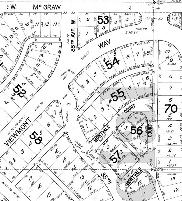
Created in 1915 as part of the plat of Carleton Park, this is one of the many streets in the subdivision that features the mont element ― Piedmont Place W, Viewmont Way W, Crestmont Place W, Eastmont Way W, and Westmont Way W among them ― a reference to the “entire district[’s]… unobstructible view of the Cascade and Olympic Mountains” (The Seattle Times).

Montavista Place W begins at Magnolia Boulevard W and goes ⅖ of a mile northeast, then northwest, to 38th Avenue W.

E Shore Drive

This private road in the gated Broadmoor neighborhood goes just under 800 feet from Broadmoor Drive E in the west to just east of Waverly Way E in the east. The northernmost street in the development, it runs parallel to the Union Bay shoreline about 950 feet to the northwest, whence its name.

“Dzidzilalich” to be honorary name for Elliott Way, Alaskan Way

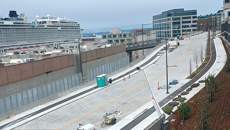
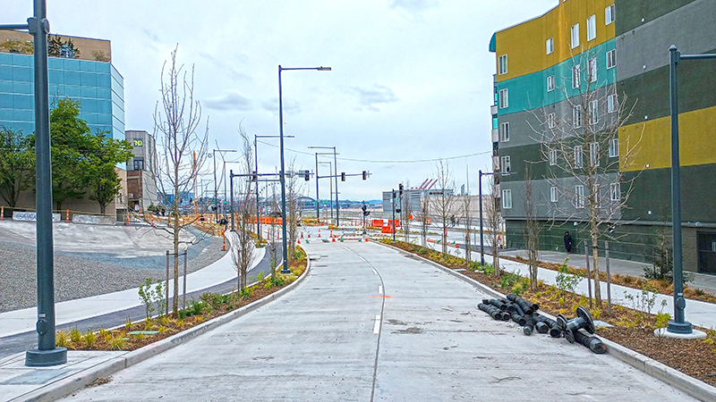
Contrary to what I wrote in “Elliott Way” just a placeholder name, it sounds like the new road connecting Western Avenue at Bell Street to Alaskan Way at Pike Street will in fact carry the official name of Elliott Way. To quote from a post on Mayor Bruce Harrell’s blog,

Mayor Bruce Harrell, City Council President Debora Juarez, and key waterfront leaders are proposing to establish an honorary name for Alaskan Way and Elliott Way, between S Dearborn St and Bell St. “Dzidzilalich” (pronounced: dzee-dzuh-lah-leech) means “Little Crossing Over Place” in the Coast Salish language Lushootseed. This honorary name would recognize the deep tribal history and culture on Seattle’s waterfront. The Dzidzilalich street name designation would be honorary; the legal name of “Alaskan Way” would not change nor would the official addresses on the street.

As I wrote in Rob Mattson Way, honorary renamings differ from official (re)namings in three important ways:

  • They are done via resolution rather than ordinance
  • They do not replace the original street name in official records and addresses
  • They appear on brown, rather than green, signs

The Waterfront Seattle page on Dzidzilalich notes that “The Suquamish and Muckleshoot Tribal Councils provided guidance to the city of Seattle’s Mayor’s Office, the Office of the Waterfront and Civic Projects, and the Seattle Department of Transportation in the process of selecting Dzidzilalich as the honorary name for this roadway.”

Mockup of a brown street sign reading Dzidzilalich

I am glad to hear that this new street will carry a Lushootseed name. To the best of my knowledge only Duwamish Avenue S and Shilshole Avenue NW do so currently. To have a major downtown street with a name like this is long overdue.

I should also note that, if this is what the tribes want, I support the proposal — and though I have some issues with it, it is not my place to tell tribal members they deserve more. I have no idea what the negotiations looked like. That said, I do have some issues with the proposal.

First, “Elliott Way” remains an incredibly uncreative name for the new roadway. I said it before and I’ll say it again: “This is a [missed] opportunity to commemorate someone, or something, new, rather than Jared, George, Samuel, or Jesse Elliott (apparently no one is sure just which Elliott the bay is named after)!” There is nothing wrong with dead white men, but take a look at the tag cloud at the bottom of this post for proof that they are far overrepresented when it comes to Seattle street names.

Second, honorary names simply don’t carry the same heft as official ones. No one calls 19th Avenue between E Madison Street and E Union Street “Rev. Dr. S. McKinney Ave,” or 15th Avenue S between S Nevada Street and S Columbian Way “Alan Sugiyama Way.” But they do call Mary Gates Memorial Drive NE, E Barbara Bailey Way, Edgar Martinez Drive S, S Roberto Maestas Festival Street, etc., by those names… because they have no other choice.

I do like the idea of giving Alaskan Way an honorary name. It is far too long and important a street to officially rename without causing a lot of issues. The last time we did something like that was when Empire Way became Martin Luther King Jr. Way in the 1980s. I’m glad that happened, but think the process would be even more drawn out and controversial today. (However, if the street that runs along our waterfront carried the name of, say, a Confederate general, I’d be among the first to call for those signs to come down.) But why just this portion of Alaskan Way? To the best of my knowledge we’ve never given an existing street an honorary name for its entire length. Why not start here, from E Marginal Way S all the way to W Garfield Street?

In addition, one reason behind honorary namings is that existing addresses don’t need to be changed. But Elliott Way is new. There are no existing addresses. Why not, then, simply call it Dzidzilalich, and give Alaskan Way another honorary name? Or, why not give Alaskan Way the honorary name Dzidzilalich for its entire length, and give Elliott Way a different name that “elevate[s] Coast Salish tribal history and culture,” as the mayor’s blog puts it?

A few asides: I, personally, would prefer the spelling Dᶻidᶻəlalič, which uses Lushootseed orthography. (If Port Angeles can do it with their Klallam-language street signs, so can we!) And I notice that only the Suquamish and Muckleshoot tribes are mentioned as having been consulted. I wonder if representatives of the Duwamish Tribe were given a chance to weigh in as well. (My guess is they weren’t, as they are not federally recognized, while the Suquamish and Muckleshoot are, and oppose the efforts of the Duwamish to gain recongition. There is a long-standing controversy regarding the legitimacy of the Duwamish as the present-day representatives of Chief Seattle’s people. See The Politics of Paying Real Rent Duwamish in Seattle Met for an interesting take on the issue.)

Regardless of what happens, though, I am glad to see “Dzidzilalic” return to Seattle’s waterfront.

Where springs of clear water bubbled from the earth and the beach was sandy and free from rocks, there the Indians camped. Such a choice spot was Tzee-tzee-lal-litch, which Arthur Denny called Spring Street.

Sophie Frye Bass, “Pig-Tail Days in Old Seattle

Lake Dell Avenue

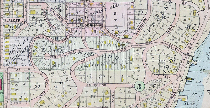
This street was created in 1890 as part of the Lake Dell Addition to the City of Seattle, the lake in question being Lake Washington, and the dell being the valley through which Lake Dell Avenue runs.

Lake Dell Avenue begins at 32nd Avenue just north of E Yesler Way and goes ⅓ of a mile to E Alder Street just west of 35th Avenue, forming part of the arterial connecting Yesler Way to Lakeside Avenue.

Portion of 1912 Baist real estate atlas of Seattle showing Lake Dell Addition
Landslide along Lake Dell Avenue, December 1933. Looking south from near the E Spruce Street right-of-way. Courtesy of the Seattle Municipal Archives, Identifier 8255
Lake Dell Avenue retaining wall, April 2012. Looking north from near the E Spruce Street right-of-way. Courtesy of the Seattle Municipal Archives, Identifier 174892

W Laurelhurst Drive NE

W Laurelhurst Drive NE and E Laurelhurst Drive NE were originally Olympic View Drive and Cascade View Drive, respectively, in the 1906 plat of Laurelhurst, an Addition to the City of Seattle. I am unable to tell exactly when the change was made: I first find “Laurelhurst Drive” being referred to in The Seattle Times in 1920, though a Kroll map from the same year shows the streets as 45th Avenue NE and 47th Avenue NE, respectively.

Laurelhurst itself was annexed to Seattle in 1910 (which makes me wonder why the plat was labelled as an addition to the city four years earlier). “Laurel” must refer to the tree, and “hurst” is an archaic word meaning “wooded hill.” However, as the English Language & Usage Stack Exchange thread that gives that definition notes, “in street names, [hurst is] likely to be a modern invention,” being part of “a name made up from old roots to imbue a sense of history and rootedness” (or, in cases like these, Britishness and stateliness). (I had thought that “Laurel” might refer to a girl or woman [cf. Loyal Avenue NW], but neither of the developers — Joseph Rogers McLaughlin [1851–1923] and Robert F. Booth [1875–1918] — appear to have had a relative by that name.)

(As an aside, the Wikipedia article on the Laurelhurst neighborhood in Portland, Oregon, citing Eugene E. Snyder’s 1979 Portland Names and Neighborhoods, says that “the name Laurelhurst was borrowed from a residential development in Seattle that Laurelhurst Company general manager Paul Murphy had recently completed. The name combined a reference to the laurel shrubbery near the Seattle development with the Old English hurst, denoting a wooded hill.” However, I have my doubts that there were actually enough laurels nearby to warrant the naming [in contrast to Magnolia, which was {mis}named for the plentiful madronas that lined the bluff].)

W Laurelhurst Drive NE begins at 43rd Avenue NE just south of NE 38th Street and goes ½ a mile southeast to just east of Webster Point Road NE, where it becomes E Laurelhurst Dr NE. From there, it goes nearly ⅖ of a mile northeast to a dead end just past 47th Avenue NE.

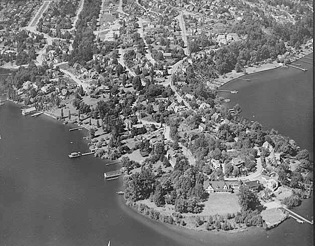
Aerial view of Laurelhurst from the south, 1938
Aerial view of Laurelhurst from the south, 1938. Webster Point dominates the view; W Laurelhurst Drive NE becomes E Laurelhurst Drive NE in front of the house that prominently appears at the southern end of the point. Photograph from the Seattle Post-Intelligencer Collection, Museum of History and Industry, licensed under Creative Commons Attribution 2.0 Generic
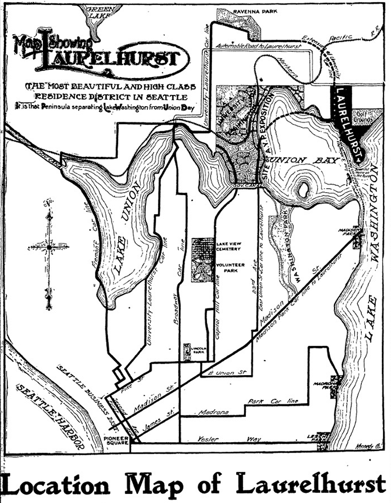
Map of Laurelhurst, Seattle Post-Intelligencer, October 21, 1906
Part of an advertisement for the new Laurelhurst subdivision, Seattle Post-Intelligencer, October 21, 1906. Laurelhurst is called “the most beautiful and high-class residence district in Seattle… that peninsula separating Lake Washington from Union Bay.” Prospective buyers were directed to take the Madison Street Cable Railway to its terminus at Madison Park, from which they could take a 5-minute ride on a steamer to Laurelhurst.

Mountain Drive W

This Magnolia street, created in 1915 as part of the plat of Carleton Park, was originally known as Mt. Olympus Drive. Because not all Seattle ordinances have been scanned, I am unable to tell when the change was made (and am unsure why it was made, as the old name doesn’t appear to conflict with anything).

The Seattle Times wrote of Carleton Park that the “entire district commands an unobstructible view of the Cascade and Olympic Mountains” ― being on the west side of the hill, the view here is of the Olympics, of which Mt. Olympus is the most prominent.

Mountain Drive W begins at Westmont Way W and Altavista Place W and goes ⅕ of a mile to Westmont Way W just east of W Viewmont Way W.

Chelan Avenue SW

This street was created in 1895 as part of the plat of Seattle’s tide lands, which featured streets named for letters of the alphabet, American cities, American states, prominent local politicians, and places in Washington. Among the latter were S Spokane Street, Duwamish Avenue S, Klickitat Avenue SW, and our current subject, Chelan Avenue SW. It appears to have been named for Lake Chelan (an anglicization of ščəl̕ámxəxʷ, meaning ‘deep water’ in Nxaʔamxcín, the language spoken by the Chelan people) — the largest natural lake in Washington and the third deepest lake in the United States (after Crater and Tahoe).

Chelan Avenue SW begins at SW Spokane Street and goes ¼ mile northwest to the West Duwamish Waterway.

Klickitat Avenue SW

Like S Spokane Street, Colorado Avenue S, and Utah Avenue S, this street was created in 1895 as part of the plat of Seattle’s tide lands. As I wrote in S Spokane Street,

Streets in this plat that were not extensions of already existing ones, such as Commercial Street, were named after letters of the alphabet, American cities, American states, prominent local politicians, and places in Washington.

Those places in Washington were Chelan, Duwamish, Kitsap, Klickitat, Queets, Quilcene, Quileute, Quinault, Spokane, Vashon, Wenatchee, and Whatcom, many (though not all) of which were themselves named after Native American groups or people. (Chelan, Duwamish, Klickitat, and Spokane are the only street names that remain.) In this particular case, we have the Klickitat River, a tributary of the Columbia in south central Washington, itself named for the Klickitat people.

Klickitat Avenue SW begins at 16th Avenue SW and goes around ⅖ of a mile southeast to SW Manning Street, all on Harbor Island.

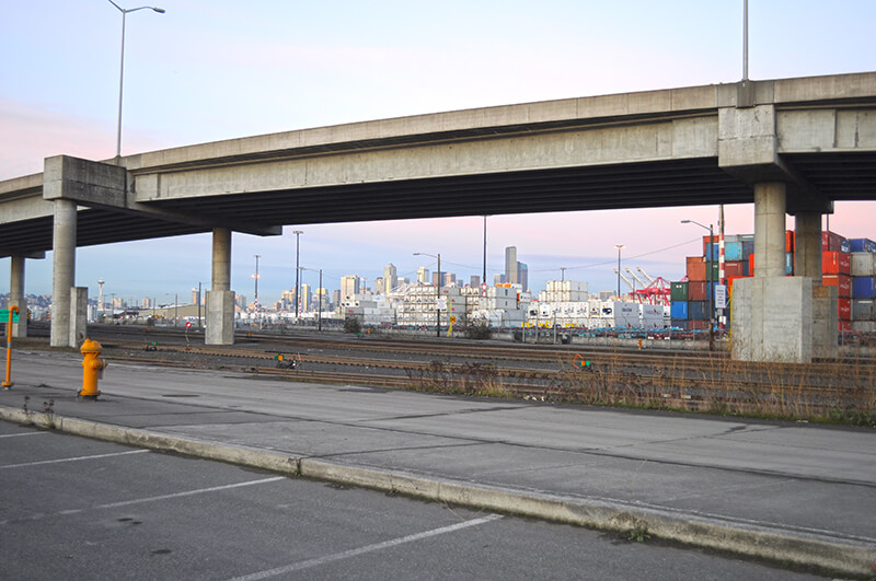
Seattle skyline from Klickitat Avenue
Looking northeast toward the Seattle skyline from Harbor Island, December 2011. The Klickitat Avenue Bridge is in the foreground. Photograph by Joe Mabel, Wikimedia Commons, licensed under Creative Commons Attribution-ShareAlike 3.0 Unported

Piedmont Place W

Created in 1915 as part of the plat of Carleton Park, this street shares the mont element with a number of other streets in the subdivision, e.g., Viewmont Way W, Crestmont Place W, Eastmont Way W, and Westmont Way W. This because, as The Seattle Times wrote, the “entire district commands an unobstructible view of the Cascade and Olympic Mountains.” I tend to think the element was overused in the neighborhood and would have liked more of its streets to be named after the actual mountains, e.g., Ellinor Drive W and Constance Drive W. But I do have to hand it to whoever came up with these names for their creativity in naming Piedmont Place W — not, I am sure, directly after the region in Italy or that in the United States, but rather because it lies at the eastern foot — pied in French — of the western Magnolia hill as it slopes down to Pleasant Valley.

Piedmont Place W begins at W McGraw Street between 36th Avenue W and 35th Avenue W and goes ¼ mile north to W Raye Street.

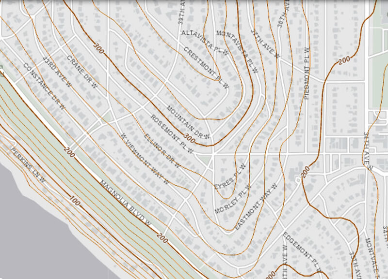
Topographic map of part of Carleton Park, from The National Map

Crestmont Place W

This street was created in 1915 as part of the plat of Carleton Park. The Seattle Times wrote of the Magnolia subdivision that the “entire district commands an unobstructible view of the Cascade and Olympic Mountains” — hence the mont portion of its name. Why crest? Because, as you can see on the topographical map below, Crestmont Place W is located at the crest of Carleton Park. (The highest point in all Magnolia, however, is located a number of blocks to the north, close to 40th Avenue W and W Barrett Lane.)

Crestmont Place W begins at Westmont Way W north of Altavista Place W and goes ¼ northeast, then northwest, to W Raye Street, where it becomes 40th Avenue W.

Topographic map of part of Carleton Park, from The National Map

Eastmont Way W

Like its twin, Westmont Way W, this street was created in 1915 as part of the plat of Carleton Park, which “afford[ed] a scenic frontage for every building lot in the addition,” according to The Seattle Times. Just as Westmont faces the Olympic Mountains to the west and southwest, Eastmont faces the Cascades to the southeast.

Beginning at Eastmont Place, a pocket park at the south end of Westmont Way W, it goes around 850 feet northeast to W McGraw Street, where it becomes 36th Avenue W.

Westmont Way W

In Viewmont Way W, I discuss the 1915 plat of Carleton Park, in which, as The Seattle Times reported,

The streets and boulevards curve and swing about the bases of elevated portions, escaping the deep cuts and heavy fills that would be necessary in conforming to the strict, rectangular plans of the old plat, and affording a scenic frontage for every building lot in the addition.

Many streets in the subdivision were named in reference to these views, Westmont Way W among them. Beginning at Eastmont Place, a pocket park at the south end of Eastmont Way W, it goes ⅖ of a mile north, then northwest, to W Viewmont Way W, providing westerly and southwesterly views of the Olympic Mountains for its entire length.

Mount Adams Place S

Like Mount Rainier Drive S, Mount St. Helens Place S, and S Mount Baker Boulevard, this street was created in 1907 as part of the Mt. Baker Park addition, named for its view of Mount Baker in the North Cascades. Like the others, it was named after a prominent Cascade Range peak — in this case, Mount Adams.

At 12,281 feet, Adams is the second tallest mountain in Washington, behind Mount Rainier. Known by Native Americans as Pahto or Klickitat, it was named for President John Adams (1735–1826), in a rather roundabout way. Unlike Rainier or St. Helens, it was neither “discovered” by George Vancouver nor named by him; instead, the first non-Natives to spot it were Lewis and Clark, who at first thought they had spotted St. Helens. Then, as Wikipedia relates,

For several decades after Lewis and Clark sighted the mountain, people continued to get Adams confused with St. Helens, due in part to their somewhat similar appearance and similar latitude. In the 1830s, Hall J. Kelley led a campaign to rename the Cascade Range as the President’s Range and rename each major Cascade mountain after a former president of the United States. Mount Adams was not known to Kelley and was thus not in his plan. Mount Hood, in fact, was designated by Kelley to be renamed after President John Adams and St. Helens was to be renamed after George Washington. In a mistake or deliberate change by mapmaker and proponent of the Kelley plan Thomas J. Farnham, the names for Hood and St. Helens were interchanged. And, likely because of the confusion about which mountain was St. Helens, he placed the Mount Adams name north of Mount Hood and about 40 miles (64 km) east of Mount St. Helens. By what would seem sheer coincidence, there was in fact a large mountain there to receive the name. Since the mountain had no official name at the time, Kelley’s name stuck even though the rest of his plan failed. However, it was not official until 1853, when the Pacific Railroad Surveys, under the direction of Washington Territory governor Isaac I. Stevens, determined its location, described the surrounding countryside, and placed the name on the map.

Mount Adams Place S begins at Mount St. Helens Place S and goes ¼ mile southeast to S Ferris Place.

Mount St. Helens Place S

Like Mount Rainier Drive S and S Mount Baker Boulevard, this street was created in 1907 as part of the Mt. Baker Park addition, named for its view of Mount Baker in the North Cascades. The neighborhood featured a number of other streets named for mountains in the Cascade Range, including this one, named after Mount St. Helens.

St. Helens, of course, is best known for its volcanic eruption on May 18, 1980, “the deadliest and most economically destructive volcanic event in U.S. history” according to Wikipedia. It was variously known by the Native Americans as Lawetlat’la (Cowlitz) and Loowit or Louwala-Clough (Klickitat), and, like Mount Rainier and Mount Baker, was given its official English-language name by George Vancouver on HMS Discovery in 1792. In this case, it honored his friend Alleyne FitzHerbert, 1st Baron St Helens (1753–1839), who at the time was British ambassador to Spain.

Mount St. Helens Place S begins at Cascadia Avenue S and goes just over ¼ mile south to Mount Rainier Drive S at 37th Avenue S.

Mount Rainier Drive S

This street was created in 1907 as part of the Mt. Baker Park addition, named for its view of Mount Baker in the North Cascades. In addition to S Mount Baker Boulevard, the neighborhood featured a number of other streets named for mountains in the Cascade Range, including this one, named after Mount Rainier.

According to Wikipedia, at 14,411 feet, Mount Rainier is “the highest mountain in… Washington and the Cascade Range, the most topographically prominent mountain in the contiguous United States, and the tallest in the Cascade Volcanic Arc.” It has been known by a number of other names, including Tacoma (after which, incidentally, Takoma Park, Maryland, was named), which derived from its Lushootseed-language name, təqʷubəʔ (‘permanently snow-covered mountain’). It was given its official English-language name by George Vancouver on HMS Discovery in 1792:

The weather was serene and pleasant, and the country continued to exhibit between us and the eastern snowy range the same luxuriant appearance. At is northern extremity, Mount Baker bore by compass N. 22 E.; the round snowy mountain, now forming its southern extremity, and which, after my friend, Rear Admiral [Peter] Rainier [17411808], I distinguish by the name of Mount Rainier, bore N. 42 E.

Mount Rainier Drive S begins at the intersection of S McClellan Street, Lake Park Drive S, and Mount Baker Drive S, and goes ¼ mile southeast to S Hanford Street and Hunter Boulevard S.

Bridge Way N

This street was created in 1930 as part of the ordinance establishing Aurora Avenue N and its approaches. Originally Wallingford Way, as it led from the north end of the Aurora Bridge to Stone Way N just south of N 40th Street, it was changed to Bridge Way in 1960. (A counterpart, Fremont Way, was also created, leading from the north end of the bridge to Fremont Avenue N at N 39th Street.)

Looking southwest down Bridge Way N from Stone Way N, January 1961. Courtesy of the Seattle Municipal Archives, Identifier 66205

High Point Drive SW

This street was named after High Point, originally developed by the Seattle Housing Authority in 1942 as defense housing and redeveloped in 2004 (see SW Bataan Street and Lanham Place SW for more history). I appear not to have mentioned in either of those posts why the development was so named — as one might guess, the city’s highest point (520 feet) is there, at the corner of 35th Avenue SW and SW Myrtle Street.

High Point Drive SW begins at 30th Avenue SW and SW Juneau Street and goes nearly ⅔ of a mile south to Sylvan Way SW and SW Holly Street.

High Point Community Center from 34th Avenue SW, April 2011. Photograph by Wikimedia Commons user Architectsea, licensed under Creative Commons Attribution-ShareAlike 3.0 Unported

Arboretum Drive E

This street in the Washington Park Arboretum was, like E Foster Island Road, originally unnamed. It received its current name in June 1957. The Arboretum itself was established in 1934 on the western half of a tract that had been logged by the Puget Mill Company; the eastern half became the gated Broadmoor neighborhood and golf course (see Broadmoor Drive E).

The street, which begins at Lake Washington Boulevard E opposite the Washington Park Playfield, goes nearly a mile north to E Foster Island Road just west of the north entrance to Broadmoor. All but the very northernmost portion, which leads to the Graham Visitors Center, has been closed to motorized traffic for over a decade.

Arboretum Drive E, October 2017. Photograph by Flickr user Steve Ginn (public domain).

Duwamish Avenue S

This street was created in 1895 as part of the Seattle Tide Lands plat. As I wrote in S Spokane Street, “Streets in this plat that were not extensions of already existing ones, such as Commercial Street, were named after letters of the alphabet, American cities, American states, prominent local politicians, and places in Washington”; these last included Chelan, Duwamish, Kitsap, Klickitat, Queets, Quilcene, Quileute, Quinault, Spokane, Vashon, Wenatchee, and Whatcom, the ones in italics still existing today. It seems strange to me that the Duwamish name would have been applied to such a short street, it being the name of Seattle’s principal river (dxwdəw) and indigenous inhabitants, the Duwamish Tribe (dxʷdəwʔabš), but there you have it. At least it still exists.

In “Elliott Way” just a placeholder name, I quote an email I wrote to the Seattle City Council and the Waterfront Seattle Program in December 2020 which read, in part, “I urge you… to name [Elliott Way] something else. The Duwamish people, for example, have Duwamish Avenue S named for them (actually more likely for the river…), but it is an insignificant street 2/10 of a mile long hidden under the Spokane Street Viaduct and the Alaskan Freeway. Perhaps Duwamish Avenue would be a better choice, if the tribe approved?” I still think this would be a good idea (and it would give us another naming opportunity as well). They did respond favorably, said they had been thinking along the same lines, and as of January 2022 “continue to coordinate with the tribes and other partners on a proposed name.” I hope they come up with something soon, as what is still being referred to as Elliott Way is due to open by year’s end!

As I mentioned in my email, Duwamish Avenue S is 2/10 of a mile long, beginning at E Marginal Way S and ending at a Port of Seattle road just south of the West Seattle and Spokane Street Bridges.

Update as of February 2, 2023: I posted an article last month  “Dzidzilalich” to be honorary name for Elliott Way, Alaskan Way — noting that, in fact, the roadway will be known as Elliott Way… but will carry the honorary name “Dzidzilalich.” So it seems “Elliott Way,” after all, is unfortunately not just a placeholder name, and for now the Duwamish name remains confined to this obscure thousand-foot-long street.

Portion of 1895 plat of Seattle Tide Lands showing Duwamish Avenue, as platted from Spokane Avenue (now Street) in the northwest to Seattle Boulevard in the southeast. The visible portion of Seattle Boulevard is now Diagonal Avenue S, Whatcom Avenue is now E Marginal Way S, and Grant Street is now Airport Way S.

Lincoln Park Way SW

This street was named for Lincoln Park, which occupies Williams Point in West Seattle. Originally called Williams Point Park in the Olmsted Brothers’ 1908 report to the city, the 135-acre park was intended to be named Fauntleroy Park. However, when it opened in 1922, it was decided to name it after President Abraham Lincoln (1809–1865) instead, according to Seattle parks historian Don Sherwood. This required that Lincoln Beach, just to the north, be renamed Lowman Beach, and that Lincoln Park Playfield on Capitol Hill (named for the adjacent Lincoln Reservoir) be renamed Broadway Playfield. (Today, the entire tract is known as Cal Anderson Park, which contains the reservoir and the once-again-renamed Bobby Morris Playfield. A Fauntleroy Park was finally established in the early 1970s.)

Lincoln Park Way SW begins at Beach Drive SW and 48th Avenue SW and goes ¼ of a mile southeast to 47th Avenue SW between SW Myrtle Street and SW Othello Street. The park begins 500 feet to the south, at the corner of 47th Avenue SW and SW Fontanelle Street.

Aerial view of Lincoln Park
Aerial view of Lincoln Park from the southwest, August 15, 2010. The heated saltwater Colman Pool, which opened in 1941, is visible at Williams Point. Photograph by Flickr user J Brew, licensed under Creative Commons Attribution-ShareAlike 2.0 Generic.