As part of the Great Renaming of 1895, Texas Street, Town Street, Fontenelle Street, Flemming Street, Davidson Street, and Canal Street became Atlantic Street, from Elliott Bay to Lake Washington. The name was extended into West Seattle in 1907, when Grant Street and Louisiana Street were combined.
Today, SW Atlantic Street begins in West Seattle at Sunset Avenue SW and goes ¼ of a mile east to Palm Avenue SW. It next appears, as S Atlantic Street, just east of U.S. Coast Guard Base Seattle at Alaskan Way S, and goes around 800 feet east to 1st Avenue S, where it becomes Edgar Martinez Drive S (renamed in honor of the ball player in 2004). Apart from a stub east of Airport Way S that is soon blocked by Interstate 5, the street’s next appearance is on Beacon Hill, where it goes ⅓ of a mile from just west of 11th Avenue S to 17th Avenue S, the portion between 15th Avenue S and 16th Avenue S being a stairway.
After being interrupted for a number of blocks by Interstate 90, S Atlantic Street reappears at 21st Avenue S and goes a block to just east of 22nd Avenue S. (Here, it gives its name to the surrounding Atlantic neighborhood.) It resumes — again having been interrupted by Interstate 90’s Mount Baker Tunnel — at Bradner Place S and goes ⅓ of a mile east to Lake Washington Boulevard S, the portions between 30th Avenue S and 31st Avenue South as well as between 32nd Avenue S and 33rd Avenue S being stairways. The right-of-way begins again at 35th Avenue S and goes around ⅛ of a mile east to Lake Washington, but is either incorporated into adjacent homeowners’ yards or serves as their driveways for most of this distance. Between Lakeside Avenue S and the water, it is one of the city’s shoreline street ends.
Born and raised in Seattle, Benjamin Donguk Lukoff had his interest in local history kindled at the age of six, when his father bought him settler granddaughter Sophie Frye Bass’s Pig-Tail Days in Old Seattle at the gift shop of the Museum of History and Industry. He studied English, Russian, and linguistics at the University of Washington, and went on to earn his master’s in English linguistics from University College London. His book of rephotography, Seattle Then and Now, was published in 2010. An updated version came out in 2015.
SW Massachusetts Street begins in West Seattle at the intersection of Bonair Drive SW, 47th Avenue SW, and Sunset Avenue SW, and goes just under ⅓ of a mile east to Palm Avenue SW. It begins again at Ferry Avenue SW and goes just over 450 feet east to Victoria Avenue SW. There is a short segment (just over 400 feet) on Harbor Island east of 13th Avenue SW, and then another one, about the same length, leading from Alaskan Way S to the entrance to U.S. Coast Guard Base Seattle. (Here, the street’s directional designation has changed to S, it being east of the Duwamish Waterway.)
S Massachusetts Street resumes at Colorado Avenue S and goes ⅙ of a mile east to Occidental Avenue S. There is a block-long segment east of 4th Avenue S to just shy of the SODO Busway, and then a longer one — about ¼ of a mile — from the SODO Trail to Airport Avenue S.
East of Interstate 5, on Beacon Hill, S Massachusetts Street begins at 11th Avenue S and goes nearly ¼ of a mile east to just past 15th Avenue S, the portion between 14th Avenue S and 15th Avenue S being pedestrian-only, as the right-of-way between the sidewalks has been turned into the Beacon Bluff P-Patch community garden. It begins again just west of Sturgus Avenue S and goes nearly a mile east to just past 31st Avenue S, the portion that runs for half a block west of 17th Avenue S being a pathway. S Massachusetts Street resumes for the last time at 32nd Avenue S and goes ¼ mile east to Lake Washington, where it is a shoreline street end.
Born and raised in Seattle, Benjamin Donguk Lukoff had his interest in local history kindled at the age of six, when his father bought him settler granddaughter Sophie Frye Bass’s Pig-Tail Days in Old Seattle at the gift shop of the Museum of History and Industry. He studied English, Russian, and linguistics at the University of Washington, and went on to earn his master’s in English linguistics from University College London. His book of rephotography, Seattle Then and Now, was published in 2010. An updated version came out in 2015.
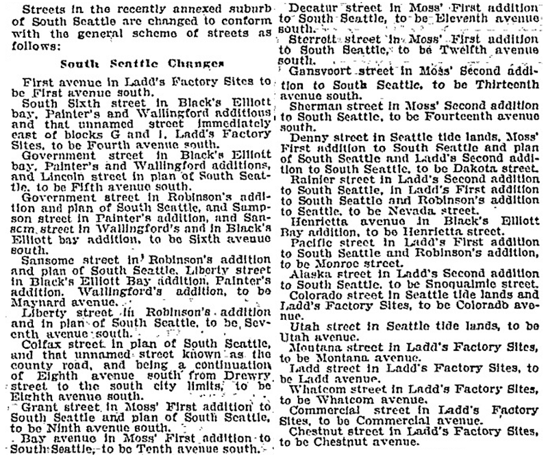
Article listing South Seattle street name changes in January 14, 1906, issue of the Seattle Post-Intelligencer
SW Nevada Street begins in West Seattle at 30th Avenue SW and goes ¼ mile east to 26th Avenue SW. It next appears east of the Duwamish Waterway in the Industrial District, as a ¼-mile-long service road off E Marginal Way S and a 300-foot-long dead-end road off 6th Avenue S. East of Interstate 5 on Beacon Hill, it goes ¼ mile east from 11th Avenue S to 16th Avenue S at Jefferson Park. It resumes for the last time in Rainier Valley at 28th Avenue S and S Adams Street and goes ¼ mile east to 31st Avenue S.
Born and raised in Seattle, Benjamin Donguk Lukoff had his interest in local history kindled at the age of six, when his father bought him settler granddaughter Sophie Frye Bass’s Pig-Tail Days in Old Seattle at the gift shop of the Museum of History and Industry. He studied English, Russian, and linguistics at the University of Washington, and went on to earn his master’s in English linguistics from University College London. His book of rephotography, Seattle Then and Now, was published in 2010. An updated version came out in 2015.
Streets in this plat that were not extensions of already existing ones, such as Commercial Street, were named after letters of the alphabet, American cities, American states, prominent local politicians, and places in Washington.… the states appear neither in alphabetical nor geographic order.
In this case, of course, the street was named for the Dakotas, not for South Dakota.
SW Dakota Street begins at 56th Avenue SW and goes 1⅓ miles east to 34th Avenue SW. It resumes at 30th Avenue SW and goes a further ⅓ of a mile east to Delridge Way SW, the portion between 28th Avenue SW and 26th Avenue SW being footpaths through the Longfellow Creek Natural Area park. SW Dakota Street begins again just west of 21st Avenue SW and goes just over 750 feet east to 19th Avenue SW, and there is one final segment west of the Duwamish Waterway between 16th Avenue SW and W Marginal Way SW.
East of the Duwamish, S Dakota Street runs for a block between 1st Avenue S and 2nd Avenue S, then picks up again at 6th Avenue S and goes ¼ mile east to 9th Avenue S. East of Interstate 5 on Beacon Hill, S Dakota Street resumes at 12th Avenue S and goes another ¼ mile east to Jefferson Park at 16th Avenue S. It begins again in the Rainier Valley at 29th Avenue S and goes ⅓ of a mile east to 34th Avenue S, picking up again at Rainier Avenue S and going ⅖ of a mile east to Genesee Park at 43rd Avenue S. On the other side of the park, it resumes at 46th Avenue S and goes ⅓ of a mile east to its end at 51st Avenue S, overlooking Lake Washington.
Born and raised in Seattle, Benjamin Donguk Lukoff had his interest in local history kindled at the age of six, when his father bought him settler granddaughter Sophie Frye Bass’s Pig-Tail Days in Old Seattle at the gift shop of the Museum of History and Industry. He studied English, Russian, and linguistics at the University of Washington, and went on to earn his master’s in English linguistics from University College London. His book of rephotography, Seattle Then and Now, was published in 2010. An updated version came out in 2015.
This street follows the route of the Rainier Avenue Electric Railway Company’s Seattle-to-Renton line, which began to be built in 1891. Both the rail line and street were named for Mount Rainier (təqʷubəʔ), itself named by Captain George Vancouver for his friend, Royal Navy Rear Admiral Peter Rainier (1741–1808). As the Seattle Post-Intelligencer noted on September 3, 1890, “the avenue points straight toward Mount Rainier, which mountain will be in plain view all the way.”
Rainier Avenue S begins at the intersection of S Jackson Street, Boren Avenue S, and 14th Avenue S, and goes nearly 8 miles southeast to the city limits. From there, it continues around 3¾ miles south to the intersection of Interstate 405 and State Route 167 in Renton.
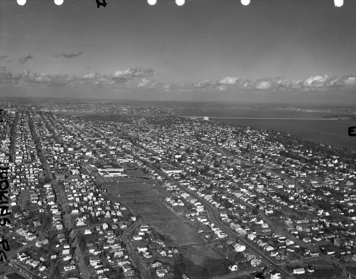
Aerial view of Rainier Valley, Beacon Hill, and Downtown, May 22, 2001. Rainier Avenue S is the tree-lined street running up the middle of the photograph. Courtesy of the Seattle Municipal Archives, Identifier 114373.
Born and raised in Seattle, Benjamin Donguk Lukoff had his interest in local history kindled at the age of six, when his father bought him settler granddaughter Sophie Frye Bass’s Pig-Tail Days in Old Seattle at the gift shop of the Museum of History and Industry. He studied English, Russian, and linguistics at the University of Washington, and went on to earn his master’s in English linguistics from University College London. His book of rephotography, Seattle Then and Now, was published in 2010. An updated version came out in 2015.
This street was created in 1900 as part of the plat of the Orchard Hill Addition, filed by Martin Dean, Sarah J. Dean, Elizabeth H. Lewis, William H. Lewis, the W.C. Hill Brick Company, and the First National Bank of Seattle. According to Don Sherwood, it was named for John J. Sturgus, “realtor and agent of [the] W.C. Hill Estate” (Hill had died in 1890).
I do find mentions of a John J. Sturgus, associated with the Hill Company or the Hill Estate, in a number of Polk directories. However, it appears a Dr. John J. Sturgus (1859–1907) was also the brother of Hill’s wife, born Alice Bradley Sturgus (1847–1904).
Article in the (Washington, D.C.) Evening Star, September 9, 1890, on the death of W.C. Hill, mentioning Mrs. Hill’s mother (“Mrs. Sturgus”) and brother (Dr. John J. Sturgus).
Given the unlikelihood of two completely different John J. Sturguses being associated with the Hills, I’m going to assume that the physician and real estate man were one and the same, and that the street was given its name either because Dr. Sturgus was Hill’s brother-in-law or because Sturgus was his wife’s maiden name (or both). If the latter, that puts it in the same category as Perkins Lane W, Thorndyke Avenue W, and Keen Way N.
Today, Sturgus Avenue S begins at S Charles Street, just east of the Jose Rizal Bridge, and goes ½ a mile southeast, then south, to S State Street. The right-of-way continues a block further, to the S Grand Street right-of-way, but houses with addresses on that block are accessed by a private alley north of 16th Avenue S.
Born and raised in Seattle, Benjamin Donguk Lukoff had his interest in local history kindled at the age of six, when his father bought him settler granddaughter Sophie Frye Bass’s Pig-Tail Days in Old Seattle at the gift shop of the Museum of History and Industry. He studied English, Russian, and linguistics at the University of Washington, and went on to earn his master’s in English linguistics from University College London. His book of rephotography, Seattle Then and Now, was published in 2010. An updated version came out in 2015.
I haven’t posted in a couple of weeks because I’ve been in Spokane, visiting my wife’s family for the holidays and attending the memorial service of my sister-in-law, may her memory be for a blessing. Since there is no Emily Street in Seattle, why not return, then, with a post on Spokane Street?
S Spokane Street looking west from 1st Avenue South, July 5, 2013. Photograph by Flickr user Curtis Cronn, licensed under Creative Commons Attribution-NonCommercial-NoDerivs 2.0 Generic. The barcodes on the support columns for the Spokane Street Viaduct was, in the words of the artwork’s creators, Claudia Reisenberger and Franka Diehnelt, intended “to ‘label’ the many layers that constitute SoDo’s history”; the word visible at upper left, ‘slóóweehL’, is a Lushootseed-language word that, according to Coll Thrush, author of Native Seattle: Histories from the Crossing-Over Place, “refers to channels, or ‘canoe-passes’, in the grassy marsh through which canoes can be pushed to effect a shortcut,” and was a Duwamish place name referring to what is now approximately 4th Avenue S and S Spokane Street. (Incidentally, this is the same word rendered as sluʔwiɫ in the IPA-based Lushootseed alphabet, which was also used as a name for what is now University Village, and is now the official name of a street on the University of Washington campus.)
Spokane Street appears to have been created in 1895 as part of the Seattle Tide Lands plat. Streets in this plat that were not extensions of already existing ones, such as Commercial Street, were named after letters of the alphabet, American cities, American states, prominent local politicians, and places in Washington. The letters of the alphabet and the American cities appear in alphabetical order, but the states appear neither in alphabetical nor geographic order, and the places in Washington do not appear to be in any order whatsoever (except that a number beginning with Q are physically clustered together). They are as follows, listed alphabetically:
(I leave out West Point Avenue [which still exists, but only as a paper street] and Seattle Boulevard [now Airport Way S and Diagonal Avenue S] because the former was named for its proximity to West Point and the latter, it seems, for its prominence.)
It isn’t a list entirely composed of cities, islands, peninsulas, lakes, or rivers… the only things I notice are ⅔ of them are in Western Washington, with Chelan, Klickitat, and Wenatchee being in Central Washington and Spokane being in Eastern Washington; plus half the Western Washington locations (those beginning with Q) are on the Olympic Peninsula. It seems what is today Spokane Street could just as easily have been something else, and what is today such a prominent street wasn’t purposefully named after what was then the state’s third largest city (today, it ranks second).
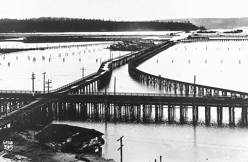
Trestles over the Elliott Bay tideflats, 1905. Photograph by Ira Webster and Nelson Stevens. According to the Wikimedia Commons entry for a similar photograph, the trestle in the foreground, running right to left (north to south), is today’s Airport Way S; the parallel trestle in the distance is 4th Avenue S; and running perpendicular from lower left to upper right (east to west, toward West Seattle) is S Spokane Street. The Seattle Box Company plant is visible at 4th and Spokane.
A modern view of the Industrial District, Harbor Island, and West Seattle from above Beacon Hill, August 15, 2010. Photograph by Flickr user J Brew, licensed under Creative Commons Attribution-ShareAlike 2.0 Generic. The freeway in the foreground, running right to left (north to south), is Interstate 5. Airport Way S is visible just west of the freeway. The Spokane Street Viaduct and West Seattle Bridge can be seen at left heading from Beacon Hill to West Seattle. 4th Avenue S is still a major arterial, though it isn’t nearly as prominent in this photograph as the one taken 105 years earlier.
Today, SW Spokane Street begins in West Seattle at Beach Drive SW, ½ a mile southeast of Alki Point, then goes nearly ½ a mile east to Schmitz Park, the block between 61st Avenue SW and 60th Avenue SW being a stairway. It resumes on the other side of the park at 51st Avenue SW and goes another ½ mile to 42nd Avenue SW. After a few interrupted segments between 35th Avenue SW and 30th Avenue SW, including another stairway, it begins again in earnest at Harbor Avenue SW and SW Admiral Way. From here it goes a full 2¼ miles east to Airport Way S, crossing the Duwamish Waterway and Harbor Island on the Spokane Street Bridge, and for this entire length runs either underneath or in the shadow of the West Seattle Bridge or the Spokane Street Viaduct, the latter of which leads to S Columbian Way on Beacon Hill.
After a short segment between Hahn Place S and 13th Avenue S, S Spokane Street begins again at 14th Avenue S and S Columbian Way and goes ⅔ of a mile east to 24th Avenue S. With the exception of an even shorter segment hanging off 25th Avenue S north of the Cheasty Boulevard greenspace, it next appears in Mount Baker, where it runs for two blocks between 33rd Avenue S and 35th Avenue S (part of this being stairway); then two more blocks between 36th Avenue S and York Road S (featuring another stairway); and two final blocks between 37th Avenue S and Bella Vista Avenue S.
Portion of 1895 plat of Seattle Tide Lands showing Spokane Avenue, now Spokane Street. The visible portion of Seattle Boulevard is now Diagonal Avenue S, and Whatcom Avenue is E Marginal Way S. Portions of Chelan Avenue, Klickitat Avenue, and Duwamish Avenue still exist, as do Oregon Street, Dakota Street, Idaho Street, Colorado Avenue, and Utah Avenue.
Born and raised in Seattle, Benjamin Donguk Lukoff had his interest in local history kindled at the age of six, when his father bought him settler granddaughter Sophie Frye Bass’s Pig-Tail Days in Old Seattle at the gift shop of the Museum of History and Industry. He studied English, Russian, and linguistics at the University of Washington, and went on to earn his master’s in English linguistics from University College London. His book of rephotography, Seattle Then and Now, was published in 2010. An updated version came out in 2015.
I have read that, and until recently assumed that, S Horton Street is named for Dexter Horton (1825–1904), but have come to wonder if it instead is named for Julius, his younger brother (1834–1904), or for the Horton family in general. Julius came to Seattle in 1869, bought land in South Seattle in 1871, and platted Georgetown in 1890, naming it after his son, George (1865–1927), who had recently become a doctor. (Georgetown became a city in 1904 and was annexed by Seattle in 1910.) S Horton Street doesn’t run through Georgetown — it’s around 2 miles north of there — but it does run through South Seattle. It appears to have been named in 1870, after Julius arrived in town but before he bought what is now Georgetown. I am not sure if Dexter had any special connection to South Seattle; he certainly never lived there.
Julius Horton and family, circa 1890. Back row, left to right: Dora Estelle (Horton) Carle, Mabel Maude (Horton) Edlund, Flora Groover, Elmer Petigoe. Front row, left to right: May Bigelow Boucher, Julius Horton, Howard Dexter Horton, Anna Emily (Bigelow) Horton, Vera Horton Hudson, George Monroe Horton, and Harry Bateman.
S Horton Street begins at E Marginal Way S and goes ⅔ of a mile east to 6th Avenue S, with a brief interruption at the SODO Busway. After a block-long segment between Airport Way S and 10th Avenue S just west of Interstate 5, it resumes on Beacon Hill at 13th Avenue S, where it goes one block east. It begins again at 16th Avenue S and goes ⅖ of a mile to 23rd Avenue S, being a stairway and pathway from just east of 19th Avenue S to 20th Avenue S. Horton resumes east of Kimball Elementary School at 24th Avenue S and goes a block and a half before it ends at the Cheasty Natural Area. Besides a very short segment just west of Martin Luther King Jr. Way S, its next appearance is at 33rd Avenue S and S Walden Street. From here, it goes ½ a mile east to Lake Washington Boulevard S, being a stairway between 36th Avenue S and 37th Place S and a stairway and pathway between Cascadia Avenue S and Sierra Drive S. Between Sierra Drive S and Lake Washington Boulevard S, it is part of Landing Parkway, under the jurisdiction of the parks department.
Born and raised in Seattle, Benjamin Donguk Lukoff had his interest in local history kindled at the age of six, when his father bought him settler granddaughter Sophie Frye Bass’s Pig-Tail Days in Old Seattle at the gift shop of the Museum of History and Industry. He studied English, Russian, and linguistics at the University of Washington, and went on to earn his master’s in English linguistics from University College London. His book of rephotography, Seattle Then and Now, was published in 2010. An updated version came out in 2015.
I initially posted that this street was named for Judge Edward Lander (1816–1907), chief justice of the territorial supreme court from 1853 to 1857. In 1855, he, along with Charles Terry, bought Carson Boren’s downtown land claim for $500. They subsequently donated two acres of land, along with Arthur Denny, who donated eight, to form the first campus of the University of Washington, which opened in 1861. The university owns the Metropolitan Tract to this day, though it moved to its present location in 1895. Lander’s name also appears on Lander Hall, a UW dormitory on NE Campus Parkway.
Edward Lander was a political foe of and was jailed by Stevens [then governor of Washington Territory] when Lander opposed Stevens’ 1855 martial law declaration and actions. Stevens and Edward Lander maintained a widely recognized lifelong enmity. It is unlikely that Hanford would have memorialized this hostility.
Frederick W. Lander
SW Lander Street begins at 59th Avenue SW in the Alki neighborhood of West Seattle, and goes ⅕ of a mile to 55th Avenue SW. It resumes just to the south at S Lander Place and goes a further ⅛ of a mile to SW Admiral Way. Picking up again at 50th Avenue SW, it makes it ½ a mile to Walnut Avenue SW before being interrupted again, as happens to so many West Seattle streets because of the varying topography. There is a final ¼-mile stretch in West Seattle from 39th Avenue SW to 36th Avenue SW, then a very short segment on Harbor Island before S Lander Street resumes in the Industrial District at Colorado Avenue S and goes ¾ of a mile east to Airport Way S. On Beacon Hill, Lander begins just west of 13th Avenue S and goes ⅔ of a mile to just past 23rd Avenue S, including the block-long stretch that is now known as S Roberto Maestas Festival Street. Lander begins again at 30th Avenue S in Mount Baker and goes a final four blocks to 34th Avenue S.
Born and raised in Seattle, Benjamin Donguk Lukoff had his interest in local history kindled at the age of six, when his father bought him settler granddaughter Sophie Frye Bass’s Pig-Tail Days in Old Seattle at the gift shop of the Museum of History and Industry. He studied English, Russian, and linguistics at the University of Washington, and went on to earn his master’s in English linguistics from University College London. His book of rephotography, Seattle Then and Now, was published in 2010. An updated version came out in 2015.
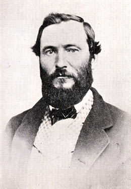
This street is named for Edward Hanford (1807–1884) and his wife, Abigail Jane Holgate (1824–1905), who left Iowa in the early 1850s to settle adjacent to Abigail’s brother, John (namesake of S Holgate Street), on what is today known as Beacon Hill but was known from then until the early 1890s as Holgate and Hanford Hill. Edward and his family were loggers, then orchardists, and unlike John Holgate, he went on to develop his donation claim.
The Hanfords’ son Clarence (1857–1920) founded, with James D. Lowman, the Lowman & Hanford Stationery and Printing Company in 1885. The firm went out of business in the 1960s, but their Pioneer Square building still, the last time I drove by, had a sign painted on it reading “Seattle’s Oldest Retail Company,” which it very well might have been when it closed. Their son Thaddeus (1847–1892) was for a time the owner of the Daily Intelligencer newspaper, predecessor of the Seattle Post-Intelligencer. And their son Cornelius (1849–1926), a federal judge from 1890 to 1912, was earlier a territorial legislator, Seattle city attorney, and chief justice of the Washington Supreme Court. He is the namesake of Hanford, Washington, and by extension the Hanford Site, which produced the plutonium used in the first nuclear explosion and the bombing of Nagasaki. He was also the author of Seattle and Environs, 1852-1924.
Edward Hanford
SW Hanford Street begins in West Seattle at SW Admiral Way and 59th Avenue SW and goes ¼ mile east to Schmitz Preserve Park at 56th Avenue SW. It begins again at 51st Avenue SW and goes nearly a mile east to 36th Avenue SW, becoming a stairway for the half-block east of 46th Avenue SW. After serving as little more than a driveway between SW Admiral Way and Fauntleroy Avenue SW, it next appears as S Hanford Street at E Marginal Way S, where it goes for ⅓ of a mile east to Occidental Avenue S. After a few short segments farther east in the Industrial District, Hanford begins again on Beacon Hill at 12th Avenue S and goes nearly a mile east to Rainier Avenue S, the segment between 25th Avenue S and Morse Avenue S being a stairway. It resumes a few blocks east at 30th Avenue S and finishes up ½ a mile east at Cascadia Avenue S.
Born and raised in Seattle, Benjamin Donguk Lukoff had his interest in local history kindled at the age of six, when his father bought him settler granddaughter Sophie Frye Bass’s Pig-Tail Days in Old Seattle at the gift shop of the Museum of History and Industry. He studied English, Russian, and linguistics at the University of Washington, and went on to earn his master’s in English linguistics from University College London. His book of rephotography, Seattle Then and Now, was published in 2010. An updated version came out in 2015.
This street is named for John Cornelius Holgate (1828–1868). Born in Ohio, he took the Oregon Trail west in 1847 and explored Elliott Bay and the Duwamish River by canoe in the summer of 1850. (The Seattle Times calls him “the first non-Indian of record to have done so.”) He returned to Oregon afterwards, however, and did not settle in what is now Seattle — specifically, Beacon Hill — until 1853, two years after the Denny Party landed at Alki Point. His mother, Elizabeth; brothers, Lemuel and Milton; and sister, Abigail, along with her husband, Edward Hanford (namesakes of S Hanford Street), soon followed. The Hanfords settled on the hill — known thereafter as Holgate and Hanford Hill until the late 1880s — adjacent to Holgate. (Milton was one of three whites to die in the Battle of Seattle in 1856, and was himself the cause of one of those deaths, having earlier shot Jack Drew, a deserting sailor from the USS Decatur, in a “friendly-fire” incident.)
A gold prospector, Holgate left for Idaho in 1863, and died there in 1868, the first casualty of the War Under the Mountain, a conflict between two rival gold mines in the Owyhee Desert, one of which he was part owner. According to Robert L. Deen, writing for True West magazine, there are conflicting accounts of Holgate’s death. The Owyhee Avalanche reported that:
Desperate fighting ensued during the charge…. John C. Holgate… one of the foremost in the advance, was shot in the head, and must have died instantaneously.
The Idaho Tri-Weekly Statesman had a slightly different story:
It appears that J.C. Holgate has been killed, some say assassinated, murdered — not killed in a fight, but shot through the head without provocation.
SW Holgate Street begins in West Seattle just west of 47th Avenue SW and goes ¼ of a mile east to California Avenue SW at Palm Avenue SW. There are two more short segments on the peninsula, between 41st Avenue SW and Arch Avenue SW and between Victoria Avenue SW and Brook Avenue SW. S Holgate Street resumes at Utah Avenue S and goes ¾ of a mile east to an overpass over Interstate 5, where it becomes Beacon Avenue S. There is a one-block stretch between 12th Avenue S and 13th Avenue S on top of the hill, and then Holgate goes a mile from the Beacon Hill Playfield at 14th Avenue S to 31st Avenue S at Colman Park, the half-block east of 16th Avenue S being a stairway and the block between 28th Avenue S and 29th Avenue S being unimproved. There is finally a short stretch east of Lakeside Avenue S at 36th Avenue S that essentially serves as a private driveway; it is a shoreline street end, but one not yet accessible to the public.
Born and raised in Seattle, Benjamin Donguk Lukoff had his interest in local history kindled at the age of six, when his father bought him settler granddaughter Sophie Frye Bass’s Pig-Tail Days in Old Seattle at the gift shop of the Museum of History and Industry. He studied English, Russian, and linguistics at the University of Washington, and went on to earn his master’s in English linguistics from University College London. His book of rephotography, Seattle Then and Now, was published in 2010. An updated version came out in 2015.
Charles Street originates in the 1876 plat of Plummer’s Addition to the City of Seattle, filed by George Washington Harris (late 1840s–1914).* How did Harris end up with the land, and why would he name the addition after Charles Plummer (who, it appears from the text of the plat description, bought the tract from David Swinson “Doc” Maynard in 1860)?
As it turns out: Plummer married Ellender Smith (sister of Dr. Henry A. Smith, namesake of Smith Cove and Smith Street) in 1855. Harris’s mother, Sarah Jane Crossman, was widowed the next year. Plummer himself became a widower when his wife died giving birth to twins Edward and Frank in 1859, and he married Harris’s mother in 1860, apparently at Maynard’s own Alki Point house. Harris then became Plummer’s stepson (and a daughter, Ida, was born to the newlyweds the next year). When Plummer died in 1866, Harris apparently inherited at least this much of his stepfather’s estate. (It’s unclear just what Edward and Ida may have received; Frank is reported to have inherited $60,000.)
Charles Plummer
Today, S Charles Street begins at Airport Way S and 6th Avenue S and is stopped a block and a half to the east at 7th Avenue S by the city’s Charles Street Service Center. (Its twin to the south, S Plummer Street, also ends at the service center, never to return.) It briefly reappears at the northern lip of Beacon Hill between 12th Avenue S and Sturgus Avenue S, and then east of Interstate 90 runs for about ⅓ of a mile between Poplar Place S and 20th Place S at Judkins Park. The right-of-way, which continues through the park, becomes an improved street again at 22nd Avenue S, and ends just east of 26th Avenue S. East of here, S Charles runs three blocks from 28th Avenue S to 30th Avenue S, and then around ¼ mile made up of alternating roadway and stairways from the alley west of 32nd Avenue S to a shoreline street end on Lake Washington — one of Leschi’s String of Pearls.
Note added October 23, 2023: S Charles Street now begins at 1st Avenue S and goes a block east to Occidental Avenue S, before resuming on the other side of Lumen Field at Airport Way S.
Born and raised in Seattle, Benjamin Donguk Lukoff had his interest in local history kindled at the age of six, when his father bought him settler granddaughter Sophie Frye Bass’s Pig-Tail Days in Old Seattle at the gift shop of the Museum of History and Industry. He studied English, Russian, and linguistics at the University of Washington, and went on to earn his master’s in English linguistics from University College London. His book of rephotography, Seattle Then and Now, was published in 2010. An updated version came out in 2015.
Because its original location is covered by King County Metro’s Atlantic Base and Interstate 5, Judkins Street now starts on Beacon Hill just west of 12th Avenue S and goes around 850 feet east to just east of 14th Avenue S, where it becomes a stairway to 15th Avenue S. The unimproved right-of-way continues through a greenbelt to 16th Avenue S, where there exists a 100-foot stretch of Judkins before it is stopped by Sturgus Avenue S, Daejon Park, and Interstate 90. On the other side of I-90, it resumes at 20th Avenue S and goes ⅘ of a mile east to Lake Washington Boulevard S, the last 50 or so feet being a stairway. Between Lake Washington Boulevard S and Lakeside Avenue S, only the first 150 feet is improved, mainly serving as a driveway for two houses. And east of Lakeside Avenue S there is a very short stretch that, like its neighbor to the north, S Norman Street, turns into a shoreline street end on Lake Washington — one of Leschi’s String of Pearls.
Built on the site of a former ravine landfill that was used for about four decades, Judkins Park was transferred to the parks department in the late 1940s and early 1950s, and opened to the public on October 8, 1977, according to a story in the October 6 issue of The Seattle Times.
Aerial view of Judkins Park and Playfield, 1965. Courtesy of the Seattle Municipal Archives, Identifier 29470. S Judkins Street is at bottom center and right, below the park. Washington Middle School is at the north end of the park and 23rd Avenue S is the arterial to its east. Lake Washington and the Evergreen Point Floating Bridge (Washington State Route 520) are visible in the distance.
Born and raised in Seattle, Benjamin Donguk Lukoff had his interest in local history kindled at the age of six, when his father bought him settler granddaughter Sophie Frye Bass’s Pig-Tail Days in Old Seattle at the gift shop of the Museum of History and Industry. He studied English, Russian, and linguistics at the University of Washington, and went on to earn his master’s in English linguistics from University College London. His book of rephotography, Seattle Then and Now, was published in 2010. An updated version came out in 2015.
For the origin of S Norman Street, we go back to our first street name post, SW Seattle Street, which read in part:
On August 4, 1869, Ike M. Hall — the executor of the estate of Norman B. Judkins — filed the Judkin’s (sic) Addition to the Town of Seattle, located just southwest of where the interchange between I-5 and I-90 is today. From north to south, the east–west streets are named Norman, B, Judkins, Addition, Town, and Seattle.
Today, S Norman Street begins on the other side of Beacon Hill, the portion shown above having been obliterated by King County Metro’s Atlantic Base and Interstate 5. (In fact, S Addition Street is the only one remaining in its original location, Judkins Street now starting on Beacon Hill and Seattle Street only existing in West Seattle.) Beginning at Poplar Place S just east of Interstate 90, it goes for a block northeast to Rainier Avenue S. It picks up again at Davis Place S and S Bush Place and goes a block east to 21st Avenue S. Resuming at 22nd Avenue S, just east of Judkins Park (also named for Norman B. Judkins), it goes ⅗ of a mile east to 33rd Avenue S, with only two short interruptions:
An unimproved stretch south of St. Gebriel Ethiopian Orthodox Church between 26th Avenue S and Martin Luther King Jr. Way S: what looks to be a bramble patch followed by a driveway for some townhouses; and
A stairway from 31st Avenue S to half a block west of 32nd Avenue S.
There appears to be a privately maintained stairway from 33rd Avenue S down to Lake Washington Boulevard S, and the next block is completely unimproved, though in both cases neighbors appear to be incorporating the right-of-way into their yards and driveways. Finally, there is a short stretch of Norman Street east of Lakeside Avenue S that turns into a shoreline street end on Lake Washington — one of Leschi’s String of Pearls.
King County Parcel Viewer showing S Norman Street between 26th Avenue S and Martin Luther King Jr. Way S. What appears to be a private driveway from Martin Luther King is actually public right-of-way.King County Parcel Viewer showing S Norman Street from 33rd Avenue S to Lake Washington. The private driveway in the public right-of-way east of Lake Washington Boulevard S (center of image) is easily visible, as is the shoreline street end east of Lakeside Avenue S.
Born and raised in Seattle, Benjamin Donguk Lukoff had his interest in local history kindled at the age of six, when his father bought him settler granddaughter Sophie Frye Bass’s Pig-Tail Days in Old Seattle at the gift shop of the Museum of History and Industry. He studied English, Russian, and linguistics at the University of Washington, and went on to earn his master’s in English linguistics from University College London. His book of rephotography, Seattle Then and Now, was published in 2010. An updated version came out in 2015.
This street, formerly the 1600 block of S Lander Street, runs between 16th and 17th Avenues S on Beacon Hill, north of the Beacon Hill light rail station and south of the Plaza Roberto Maestas housing development of El Centro de la Raza, a social service agency. It was renamed in 2011 in honor of Roberto Maestas (1938–2010), who co-founded El Centro in 1972 in the recently closed Beacon Hill Elementary School.
The street is one of a number of “festival streets” in the city of Seattle: “designated portions of streets intended for frequent public events.” E Barbara Bailey Way is the other one we’ve covered so far.
Born and raised in Seattle, Benjamin Donguk Lukoff had his interest in local history kindled at the age of six, when his father bought him settler granddaughter Sophie Frye Bass’s Pig-Tail Days in Old Seattle at the gift shop of the Museum of History and Industry. He studied English, Russian, and linguistics at the University of Washington, and went on to earn his master’s in English linguistics from University College London. His book of rephotography, Seattle Then and Now, was published in 2010. An updated version came out in 2015.
This Olmsted boulevard was designed in 1910 as Jefferson Boulevard, the entrance to Jefferson Park. It runs about 1⅕ miles from Beacon Avenue S and S Alaska Street in the southwest to S Winthrop Street in the northeast, which also forms part of the park boulevard. After crossing Martin Luther King Jr. Way S and Rainier Avenue S, it continues on as S Mount Baker Boulevard, ending at Mount Baker Park.
In 1914, it was renamed Cheasty Boulevard after E.C. (Edward) Cheasty (born 1864), who died that year. He had been police commissioner, commissioner of the Alaska–Yukon–Pacific Exposition, and a member of the park board from 1907 to 1910 and 1912 to his death, according to the Don Sherwood Park History Files. He also ran Cheasty’s Store, a downtown haberdashery, from 1888 until his death.
Speaking of his death, it sadly appears that it was due to suicide. He fell from the 10th floor of the Washington Hotel — the same hotel in which fellow businessman Frank B. Hubbell killed himself in 1905.
Front-page article on Cheasty’s death, The Seattle Star, June 13, 1914
Born and raised in Seattle, Benjamin Donguk Lukoff had his interest in local history kindled at the age of six, when his father bought him settler granddaughter Sophie Frye Bass’s Pig-Tail Days in Old Seattle at the gift shop of the Museum of History and Industry. He studied English, Russian, and linguistics at the University of Washington, and went on to earn his master’s in English linguistics from University College London. His book of rephotography, Seattle Then and Now, was published in 2010. An updated version came out in 2015.
What better way to start things off than with SW Seattle Street?
SW Seattle Street is a minor residential street in West Seattle that runs about ³/₁₀ of a mile from 42nd Avenue SW in the east to Sunset Avenue SW in the west.
It might seem strange that such a short street would be chosen to bear the city’s name — it was the only one to do so until 2010, when the first two blocks of Airport Way S were renamed Seattle Boulevard S — but this has more to do with unimaginative naming than with civic pride.
On August 4, 1869, Ike M. Hall — the executor of the estate of Norman B. Judkins — filed the Judkin’s (sic) Addition to the Town of Seattle, located just southwest of where the interchange between I-5 and I-90 is today. From north to south, the east–west streets are named Norman, B, Judkins, Addition, Town, and Seattle.
Portions of the original Seattle Street were vacated over the years (for example, in 1900, 1957, and 2000), and the construction of I-5 took care of the rest. However, when the city annexed West Seattle in 1907 it changed the name of Maple Street to W Seattle Street as part of rationalizing the street grid… and so the name lives on.
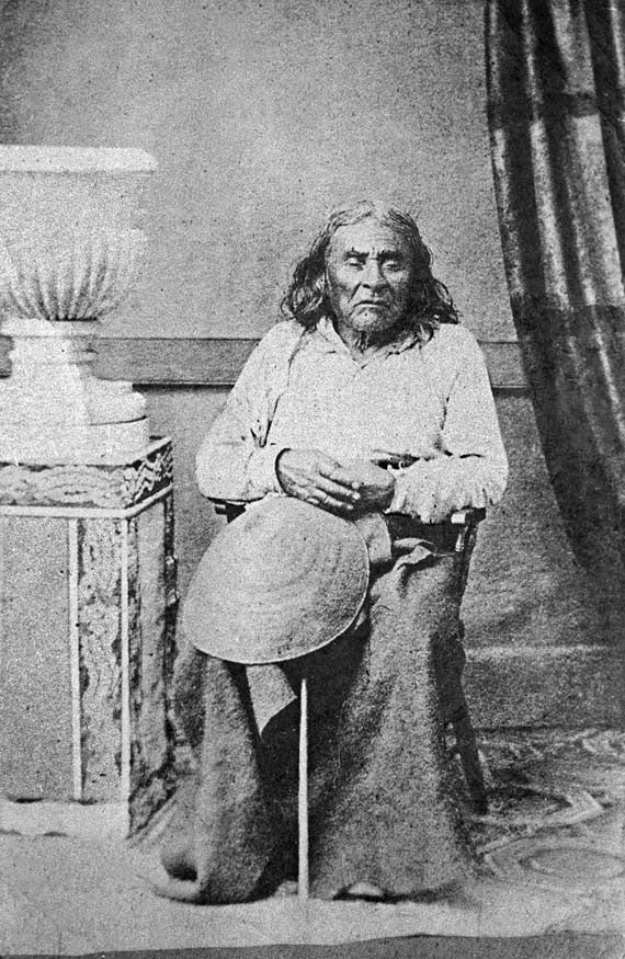
(The city itself, of course, was named after Si’ahl [siʔaɫ], better known in English as Chief Seattle of the Duwamish and Suquamish Tribes.)
The only known photograph of Chief Seattle (1786?–1866), taken by E.M. Sammis in 1864
So, why SW Seattle Street instead of Seattle Street SW?
In Seattle, east–west streets have the directional come first, and north–south avenues have it come last. The Wikipedia article “Street layout of Seattle,” which I helped write, has a more comprehensive description of Seattle’s addressing system, including the answer to this question:
Why was it W Seattle Street in 1907 but SW Seattle Street now?
In 1961, city ordinance 89910 “established a standard system of street name designations” so that in almost all cases streets within a given zone would carry the same directional. West Seattle avenues already carried the SW designation.
Born and raised in Seattle, Benjamin Donguk Lukoff had his interest in local history kindled at the age of six, when his father bought him settler granddaughter Sophie Frye Bass’s Pig-Tail Days in Old Seattle at the gift shop of the Museum of History and Industry. He studied English, Russian, and linguistics at the University of Washington, and went on to earn his master’s in English linguistics from University College London. His book of rephotography, Seattle Then and Now, was published in 2010. An updated version came out in 2015.


.jpg)
.jpg)