This Queen Anne street was established in 1923 as Lee Place and received its current name in 1924. It was likely named for the Queen Anne Standpipes, a pair of water towers nearby that were built in 1900 and 1901 and served the neighborhood until 2007. Even though they were historical landmarks, they were subsequently demolished and replaced with the current single tower.
Interestingly, though its lack of a directional designation (e.g., Tower Place N) would imply it’s an east–west street, the quarter section map appears to indicate it’s both, beginning at Lee Street just south of Observatory Courts and going 175 feet south to a dead end, and beginning halfway down the aforementioned segment and going around 100 feet east to a dead end.
An “early 20th century,” according to Paul Dorpat, postcard of the water towers and adjacent fire station
Born and raised in Seattle, Benjamin Donguk Lukoff had his interest in local history kindled at the age of six, when his father bought him settler granddaughter Sophie Frye Bass’s Pig-Tail Days in Old Seattle at the gift shop of the Museum of History and Industry. He studied English, Russian, and linguistics at the University of Washington, and went on to earn his master’s in English linguistics from University College London. His book of rephotography, Seattle Then and Now, was published in 2010. An updated version came out in 2015.
This Lower Queen Anne street adjacent to the Seattle Center campus was named in honor of Seattle Storm basketball star Sue Bird (born 1980) in the fall of 2024. As Ordinance 121704 says,
Sue Bird is the winningest and greatest women’s professional basketball player of all time; and… played her entire 20-year professional career for the Seattle Storm, bringing home to Seattle four WNBA titles (2004, 2010, 2018, and 2020), while also winning five Olympic gold medals (2004-2020).
This, incidentally, makes Sue Bird the third Jew and the first Jewish woman to have a Seattle street named for her (Cowen Place NE and Fuhrman Avenue E are the other two).
Originally 2nd Avenue N, the street (obviously redesignated a court in a nod to Bird’s sport) begins at the intersection of 2nd Avenue and Denny Way and goes just over 800 feet north to Lenny Wilkens Way, named for another Seattle basketball star. (North of there, its name changes to Seattle Storm Way.)
Born and raised in Seattle, Benjamin Donguk Lukoff had his interest in local history kindled at the age of six, when his father bought him settler granddaughter Sophie Frye Bass’s Pig-Tail Days in Old Seattle at the gift shop of the Museum of History and Industry. He studied English, Russian, and linguistics at the University of Washington, and went on to earn his master’s in English linguistics from University College London. His book of rephotography, Seattle Then and Now, was published in 2010. An updated version came out in 2015.
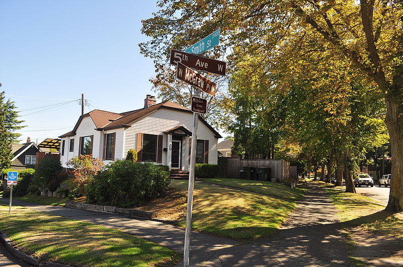
This block-long Queen Anne street is named for Ward Street, itself named after Dillis B. Ward (1838-1922). It was established in 1903 by Ordinance 9310 as East Queen Anne Drive. It may have been renamed later that year by Ordinance 10261, but as the latter ordinance has not yet been scanned by the city, we know it amends the section of the earlier ordinance dealing with the street — but not exactly how.
Ward Place begins at Taylor Avenue N just north of Aloha Street and goes 330 feet northeast to Ward Street just west of 6th Avenue N (intersection pictured below).
Incidentally, Seattle City Councilman Hiram C. Gill (1866–1919), who would go on to become mayor from 1910–1911 and 1914–1918, was adamantly against its construction, and was no fan of the residents of East Queen Anne, either:
Just a few nights ago those yellers up there held a meeting and denounced this council as a lot of grafters that were into all kinds of corruption, and now they come right down here and demand that we give them something that nobody else would have the gall to ask for. It is time that bunch should be set back a little. There are only about two dozen people living up there anyway and there is no reason why a lot of money should be spent for improvements for a handful of people when no other part of the city can get anything in the way of special favors. That crowd up there has been getting one thing after another just because they holler for it. They are just a lot of cheeky grafters anyway. I wouldn’t care if there was any kind of decent people living up there but if those fellows had to walk up hill every day and then were put in jail and kept there until Hades froze over they would be getting just about what they want.
Article in the December 22, 1903, issue of the Seattle Post-Intelligencer
Born and raised in Seattle, Benjamin Donguk Lukoff had his interest in local history kindled at the age of six, when his father bought him settler granddaughter Sophie Frye Bass’s Pig-Tail Days in Old Seattle at the gift shop of the Museum of History and Industry. He studied English, Russian, and linguistics at the University of Washington, and went on to earn his master’s in English linguistics from University College London. His book of rephotography, Seattle Then and Now, was published in 2010. An updated version came out in 2015.
This pedestrianized stretch of 2nd Avenue N on the Seattle Center campus was renamed in 2018 after the Seattle Storm WNBA team, themselves so named “because of the weather here and what the team plans to do in the league.” Founded in 2000, their home court is Climate Pledge Arena, located between Seattle Storm Way and 1st Avenue N along Lenny Wilkens Way (formerly the 100 block of Thomas Street)
Before the 1962 Century 21 Exposition that brought Seattle the Space Needle and Monorail, 2nd Avenue N (earlier Poplar Avenue) continued north to Mercer Street and up Queen Anne Hill. The stretch between Thomas and Mercer Streets would remain a public right-of-way after its pedestrianization for nearly 30 years until it was vacated in 1991 at the request of Seattle Center “for the purpose of security and event control.”
Seattle Storm Way begins at Lenny Wilkens Way and goes a block north to the old Harrison Street right-of-way; the walkway between there and Mercer Street remains unnamed.
Born and raised in Seattle, Benjamin Donguk Lukoff had his interest in local history kindled at the age of six, when his father bought him settler granddaughter Sophie Frye Bass’s Pig-Tail Days in Old Seattle at the gift shop of the Museum of History and Industry. He studied English, Russian, and linguistics at the University of Washington, and went on to earn his master’s in English linguistics from University College London. His book of rephotography, Seattle Then and Now, was published in 2010. An updated version came out in 2015.
This street was created in 1905 as part of the plat of the Sound View Addition to Queen Anne. Originally a loop off 11th Avenue W and carrying that name, at some point it was renamed after the addition — which itself was named for its fine view of Puget Sound. (I have been unable to find the renaming ordinance, so don’t know exactly when the change was made.)
Smith Cove, Interbay, and Magnolia from Soundview Terrace Park, July 2008. The industrial area at center is the Port of Seattle’s Terminal 91, the BNSF Railway’s Balmer Yard, and the Washington National Guard’s Seattle Readiness Center. Beyond the Magnolia Bridge is the Elliott Bay Marina. Photograph by Joe Mabel, Wikimedia Commons, licensed under Creative Commons Attribution-Share Alike 3.0 Unported
Soundview Terrace Playground, July 2015. Sound View Terrace W is between the playground and the houses, all of which have Westview Drive W or 11th Avenue W addresses. Courtesy of the Seattle Municipal Archives, Identifier 178590
Portion of the 1905 plat. Smith and Wild Rose Streets are now W Wheeler Street; the curving portion of 11th Avenue W is now Sound View Terrace W.
Born and raised in Seattle, Benjamin Donguk Lukoff had his interest in local history kindled at the age of six, when his father bought him settler granddaughter Sophie Frye Bass’s Pig-Tail Days in Old Seattle at the gift shop of the Museum of History and Industry. He studied English, Russian, and linguistics at the University of Washington, and went on to earn his master’s in English linguistics from University College London. His book of rephotography, Seattle Then and Now, was published in 2010. An updated version came out in 2015.
I haven’t posted in two weeks because I recently had the good fortune to visit, and the sad duty to return from, Maui, “the Valley Isle,” second largest of the Hawaiian Islands. That made me think, as I posted about S Spokane Street after traveling there last December, it would be appropriate to post about Aloha Street today.
Four and a half years ago, local historian Valarie Bunn wrote a post on her Wedgwood in Seattle History blog called “Searching for the Origin of Seattle Street Names.” It begins “There is no resource list of the meanings of Seattle’s street names or how the street names were derived,” and that was certainly true at the time. (One reason I started Writes of Way the next year was to eventually provide such a list — and now I rate a mention at the end of her article!) She continues:
Some street names are apparent in their derivation when honoring an early settler, such as Denny Way for the original homestead claim property of David Denny (Arthur’s younger brother) and Mercer Street for Thomas Mercer, an early, influential settler of Seattle. But for some other street names, such as Aloha Street, we may feel bewildered as we wonder, what is “Aloha” for?
She goes on to give a tutorial in trying to determine street name origins. She first notes that the street name was extended beyond Lower Queen Anne as part of the Great Renaming of 1895, and that its first appearance was as part of the 1875 plat of D.T. Denny’s Second Addition to North Seattle (as this part of South Lake Union then was). David Thomas Denny (1832–1903) and Louisa Boren Denny (1827–1916) were members of the Denny Party, who landed at Alki Point in 1851 and are considered the founders of modern Seattle. Here, though, the trail ends, as
The Dennys’ plat map of 1875 does not tell us why David and Louisa Denny chose the street names that they did, including “Aloha.”
But, she continues,
From earliest days, the Dennys knew that lumber was being shipped out from Seattle to San Francisco and as far as Hawaii, so our best guess is that they chose the word “Aloha” as a reference to Seattle’s trade connections.
Not as definitive an answer as the one she goes on to give for Cleopatra Place NW, but a pretty good one nevertheless, and one I can’t improve upon.
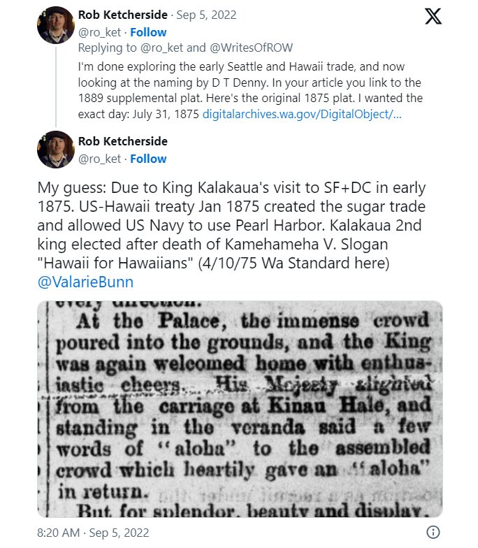
Note: On September 5, my friend, local historian Rob Ketcherside, did a bit of a dive into the matter. He began thus —
— and came to this conclusion:
I had come across the Reciprocity Treaty when trying to find any connection between Seattle and Hawaii in 1875,but…
So there, for now, the matter lies.
Note added August 13, 2023: The devastating Lāhainā wildfiremade me want to re-read this article, and I realized I neglected to discuss the route Aloha Street takes through Seattle. It begins at 1st Avenue W as W Aloha Street, and becomes Aloha Street a block to the east as it crosses Queen Anne Avenue N. From there, it goes ¾ of a mile east to Westlake Avenue N, where it is interrupted by Lake Union. It resumes at Fairview Avenue N and goes ⅙ of a mile east through the Fred Hutch Cancer Center campus to Eastlake Avenue E. On the other side of Interstate 5, it picks up again at Boylston Avenue E and goes an uninterrupted 1⅓ mileseast to its end at the intersection of 29th Avenue E and E Ward Street at the west end of the Washington Park Playfield.
Note: On August 20, 2024, I finished converting embedded tweets on this website to screenshots because of issues with how they were integrating with WordPress, which began not too long after Elon Musk purchased Twitter and changed its name to X.
Born and raised in Seattle, Benjamin Donguk Lukoff had his interest in local history kindled at the age of six, when his father bought him settler granddaughter Sophie Frye Bass’s Pig-Tail Days in Old Seattle at the gift shop of the Museum of History and Industry. He studied English, Russian, and linguistics at the University of Washington, and went on to earn his master’s in English linguistics from University College London. His book of rephotography, Seattle Then and Now, was published in 2010. An updated version came out in 2015.
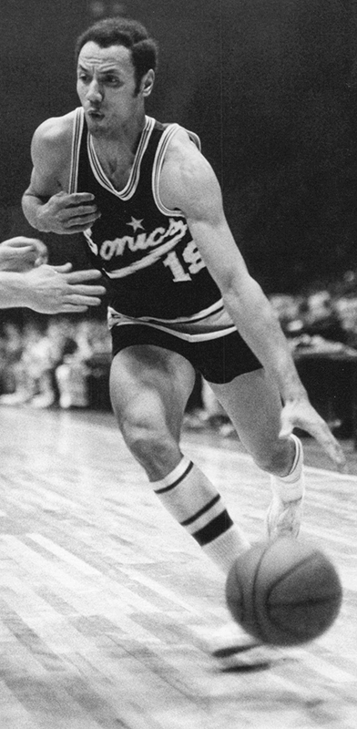
I’m not sure how I missed the news, but in December 2021 the block of Thomas Street between 1st Avenue N and 2nd Avenue N/Seattle Storm Way, just south of Climate Pledge Arena, was officially renamed Lenny Wilkens Way, after the Seattle basketball legend.
Leonard Randolph Wilkens (born 1937), who grew up in Brooklyn, New York, played basketball for the Seattle SuperSonics from 1968–1972, also serving as head coach from 1969–1972. He returned to coach the Sonics in 1977 and stayed until 1986, when he went to the Cleveland Cavaliers. He led the Sonics to two consecutive NBA championship games, in 1978 and 1979, the latter of which the Sonics won, giving Seattle its first national title since the Metropolitans won the Stanley Cup in 1917, and its last until 2004, when the Storm won the WNBA Championship. Wilkens finished his career as head coach of the New York Knicks in 2005. Through the Lenny Wilkens Foundation, which recently wound up operations, he also raised millions of dollars for Seattle Children’s Odessa Brown Children’s Clinic.
As far as I know, and please correct me if I’m wrong, this makes Lenny Wilkens only the second Black person to have a street named after him in Seattle, the first being Martin Luther King Jr.
At left, Lenny Wilkens in 1968; public domain photograph by Malcolm Emmons of The Sporting News. At right, Wilkens in 2013; public domain photograph by Technical Sergeant Samuel Morse, U.S. Air Force.
Born and raised in Seattle, Benjamin Donguk Lukoff had his interest in local history kindled at the age of six, when his father bought him settler granddaughter Sophie Frye Bass’s Pig-Tail Days in Old Seattle at the gift shop of the Museum of History and Industry. He studied English, Russian, and linguistics at the University of Washington, and went on to earn his master’s in English linguistics from University College London. His book of rephotography, Seattle Then and Now, was published in 2010. An updated version came out in 2015.
This North Queen Anne street originates in the 1907 Mayfair Addition to the City of Seattle, filed by the Mayfair Land Company. Don Sherwood notes that “Mayfair is a fashionable district in London, east of Hyde Park,” which was named after the annual May Fair (1686–1764).
Advertisement for the Mayfair Addition in The Seattle Times, March 8, 1907
Mayfair Avenue N begins at Florentia Street between 2nd Avenue N and 3rd Avenue N and goes just over ¼ of a mile south to just past Mayfair Park, where it becomes a private road that goes around 600 feet east to Nob Hill Avenue N. The private section runs through land once owned by the Lorentz family (Lorentz Place N) — in fact, a few members still own houses there.
Born and raised in Seattle, Benjamin Donguk Lukoff had his interest in local history kindled at the age of six, when his father bought him settler granddaughter Sophie Frye Bass’s Pig-Tail Days in Old Seattle at the gift shop of the Museum of History and Industry. He studied English, Russian, and linguistics at the University of Washington, and went on to earn his master’s in English linguistics from University College London. His book of rephotography, Seattle Then and Now, was published in 2010. An updated version came out in 2015.
This street was created in 1890 as part of the Queen Anne 3rd Addition to the City of Seattle, platted by Frank Morrell Jordan (1863–1931) of F.M. Jordan & Co. According to Clarence Bagley’s History of Seattle from the Earliest Settlement to the Present Time, he had been “connected with Seattle throughout the entire period of its development since the fire of 1889 and has been in hearty sympathy with the movement for the building of the city upon broader and more beautiful municipal lines.”
As the street is less than 150 feet south of Mount Pleasant Cemetery, I assume that is the origin of its name.
W Pleasant Place exists in two short segments not much longer than 150 feet each. Both head east: one from 7th Avenue W and the other from 6th Avenue W, neither making it a whole block.
Born and raised in Seattle, Benjamin Donguk Lukoff had his interest in local history kindled at the age of six, when his father bought him settler granddaughter Sophie Frye Bass’s Pig-Tail Days in Old Seattle at the gift shop of the Museum of History and Industry. He studied English, Russian, and linguistics at the University of Washington, and went on to earn his master’s in English linguistics from University College London. His book of rephotography, Seattle Then and Now, was published in 2010. An updated version came out in 2015.
This street was created in 1890 as part of Hunter’s Lake Union Addition to the City of Seattle by Colonel Morton C. Hunter (1825–1896), Civil War veteran and congressman from Indiana. (His son, Frank, was an insurance and real estate man in Seattle, and it was he who requested the recording of the plat.) Absent any evidence to the contrary, I assume it was named for the tree, though it is the only such street in the plat.
Birch Avenue N begins at Halladay Street just east of Aurora Avenue N and south of Canlis, and goes 300 feet southeast to a dead end.
Born and raised in Seattle, Benjamin Donguk Lukoff had his interest in local history kindled at the age of six, when his father bought him settler granddaughter Sophie Frye Bass’s Pig-Tail Days in Old Seattle at the gift shop of the Museum of History and Industry. He studied English, Russian, and linguistics at the University of Washington, and went on to earn his master’s in English linguistics from University College London. His book of rephotography, Seattle Then and Now, was published in 2010. An updated version came out in 2015.
Elliott Avenue begins at Western Avenue and Lenora Street and goes 2⅕ miles northwest to halfway between W Galer Street and W Garfield Street, where it becomes 15th Avenue W.
Looking south down Elliott Avenue W at W Mercer Place, August 1921. Courtesy of the Seattle Municipal Archives, Identifier 1862
Born and raised in Seattle, Benjamin Donguk Lukoff had his interest in local history kindled at the age of six, when his father bought him settler granddaughter Sophie Frye Bass’s Pig-Tail Days in Old Seattle at the gift shop of the Museum of History and Industry. He studied English, Russian, and linguistics at the University of Washington, and went on to earn his master’s in English linguistics from University College London. His book of rephotography, Seattle Then and Now, was published in 2010. An updated version came out in 2015.
Like Queen Anne Avenue N, Queen Anne Boulevard is named for the neighborhood and hill, themselves named for the Queen Anne architectural style popular with builders in the 1880s. Unlike the avenue, though, the boulevard is not one single street, but a scenic loop incorporating many streets (and hence has no directional designation, such as Queen Anne Boulevard W).
The legislation establishing Queen Anne Boulevard was passed in 1907, and construction took place from 1911 to 1916. The Seattle Department of Transportation has had jurisdiction over the streets since 1942; jurisdiction over the landscaping remains with Seattle Parks and Recreation.
The loop is slightly over 3⅔ miles in length; the ordinance gives its route as follows (edited for style and current street names and directional designations, with notes added):
Extending from Prospect Street between Warren Avenue N and 2nd Avenue N, in a northeasterly direction*, to an intersection with Galer Street near Bigelow Avenue N; thence northerly following the general direction of Bigelow Avenue N as nearly as the contours of the ground will permit, to Wheeler Street; thence westerly to Nob Hill Avenue N; thence southerly to McGraw Street; thence westerly to 2nd Avenue N; thence northwesterly to Smith Street†, west of Warren Avenue N; thence westerly along Smith Street to a point east of 1st Avenue W; thence southerly to W McGraw Street and 2nd Avenue West‡; thence westerly to 3rd Avenue W; thence northwesterly to 5th Avenue W and W Smith Street§; thence northerly to W Raye Street; thence westerly to 8th Avenue W; thence northerly to W Armour Street; thence northwesterly to W Fulton Street; thence westerly to 9th Avenue W; thence southwesterly to 10th Avenue W and W Armour Street; thence southerly to W Wheeler Street; thence easterly to 8th Avenue W; thence southerly to W McGraw Street; thence easterly to 7th Avenue W; thence southerly to W Blaine Street; thence westerly to 8th Avenue W; thence southerly to W Lee Street; thence southeasterly to W Highland Drive and 7th Avenue West¶.
* Now the southern extension of Bigelow Avenue N. † Now McGraw Place. ‡ Now the east half of W McGraw Place. § Now the west half of W McGraw Place. ¶ Now 8th Place W.
Notably, there is a gap in the loop; Highland Drive between 7th Avenue W and Warren Avenue N could have made it closed, but this was not done.
“Queen Anne Boulevard, Seattle Historic Landmark” Parks Department sign, 1st Avenue W and W Smith Street, July 2015. Courtesy of the Seattle Municipal Archives, Identifier 178301
Queen Anne Boulevard at night: 8th Place W just north of Marshall Park, July 2015. Note the Wilcox Wall supporting the light fixtures. Courtesy of the Seattle Municipal Archives, Identifier 178303
Born and raised in Seattle, Benjamin Donguk Lukoff had his interest in local history kindled at the age of six, when his father bought him settler granddaughter Sophie Frye Bass’s Pig-Tail Days in Old Seattle at the gift shop of the Museum of History and Industry. He studied English, Russian, and linguistics at the University of Washington, and went on to earn his master’s in English linguistics from University College London. His book of rephotography, Seattle Then and Now, was published in 2010. An updated version came out in 2015.
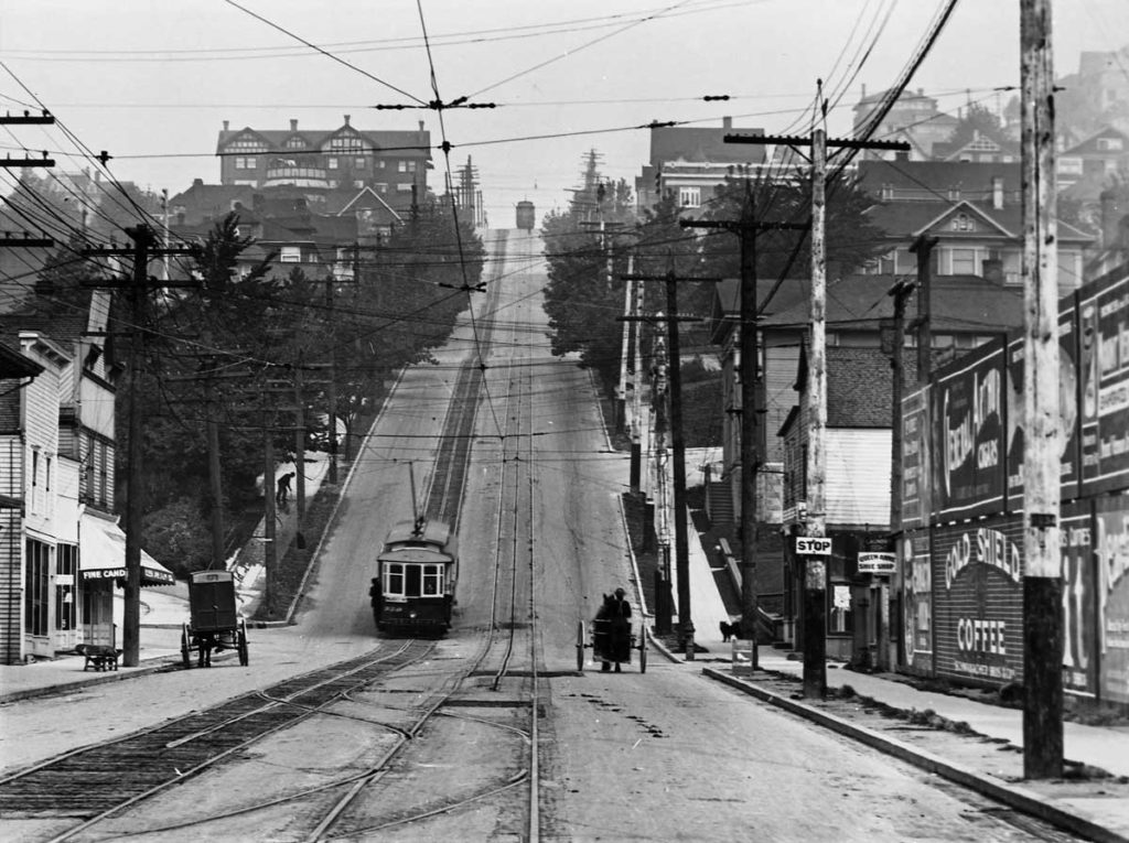
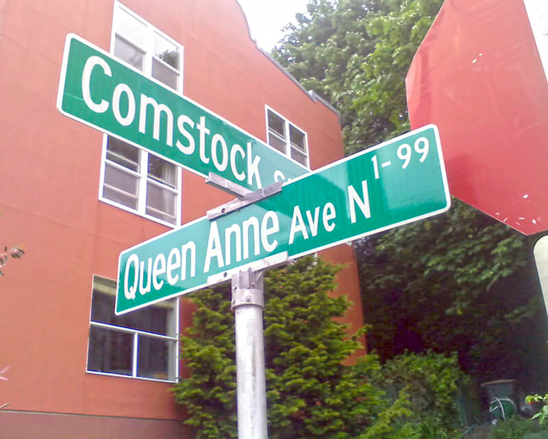
Originally Temperance Street and Villard Avenue, Queen Anne Avenue N was given its current name in 1895 as part of the Great Renaming. It was named after Queen Anne Hill and the Queen Anne neighborhood. Originally called Eden Hill or Galer Hill, they were themselves renamed after the Queen Anne architectural style that became popular in the 1880s.
Looking north up the Counterbalance (Queen Anne Avenue N), 1910
Queen Anne Avenue begins at Western Avenue, less than 100 feet south of Denny Way, and becomes Queen Anne Avenue N as it crosses Denny. From there it goes 2⅕ miles north to Bertona Street and the Ship Canal Trail.
Born and raised in Seattle, Benjamin Donguk Lukoff had his interest in local history kindled at the age of six, when his father bought him settler granddaughter Sophie Frye Bass’s Pig-Tail Days in Old Seattle at the gift shop of the Museum of History and Industry. He studied English, Russian, and linguistics at the University of Washington, and went on to earn his master’s in English linguistics from University College London. His book of rephotography, Seattle Then and Now, was published in 2010. An updated version came out in 2015.
In the early 1870s, the Denny and Mercer families gradually began to systematically subdivide their large land holdings on the south and east slopes of Queen Anne Hill. When a severe windstorm blew down thousands of trees in the north district in 1875, views opened up and land seekers turned their attentions beyond Belltown. Real estate speculators new to the territory arrived and began to buy up property on the crest of Queen Anne Hill. Some of these speculators also became developers, such as George Kinnear, or builder-developers, such as Isaac Bigelow.
Bigelow Avenue N forms a major part of Queen Anne Boulevard, the scenic loop atop Queen Anne Hill. It begins at 2nd Avenue N and Prospect Street and goes 9⁄10 of a mile to Wheeler Street between 4th Avenue N and 5th Avenue N.
Part of the street is lined with chestnut trees — not horse chestnuts, but the edible variety, specifically the Chinese chestnut, Castanea mollissima, according to the city’s records. My family (my mother was Korean) never foraged here, though we have done so elsewhere in the area, both for chestnuts and fiddlehead ferns. But plenty of others have, and continue to do so, as these articles show:
It should be noted that since Bigelow Avenue N is part of Queen Anne Boulevard, the trees belong to the parks department, not to the neighbors. As with similar park boulevards in town, neighbors’ yards often encroach on the public right-of-way.
Born and raised in Seattle, Benjamin Donguk Lukoff had his interest in local history kindled at the age of six, when his father bought him settler granddaughter Sophie Frye Bass’s Pig-Tail Days in Old Seattle at the gift shop of the Museum of History and Industry. He studied English, Russian, and linguistics at the University of Washington, and went on to earn his master’s in English linguistics from University College London. His book of rephotography, Seattle Then and Now, was published in 2010. An updated version came out in 2015.
“But,” you might say, “if he developed Fremont, why is W Blewett Way in Queen Anne?”
As you can see in the map below, and in this plat he filed in 1888 of what is now Fremont and North Queen Anne before the Fremont Cut was dug, Ewing and Blewett Streets used to be part of both neighborhods. When they became separated, the names were left alone on the Queen Anne side; in Fremont, they were changed as follows: Kilbourne to N 36th Street, Blewett to N 35th Street, and Ewing to N 34th Street.
Portion of 1912 Baist Atlas showing Fremont Cut
It’s not quite that simple, though — Blewett never reached quite as far as 13th Avenue W. What appears to have happened is that a name was needed when what is now W Blewett Way was created in 1907, and because the street to the south was still Ewing, Blewett presented itself as a natural choice. The rest of Blewett south of the canal was vacated over the years, so this is all that’s left of the name.
Today, W Blewett Way begins at the north end of 13th Avenue W and goes east just about ⅒ of a mile before it becomes a private driveway.
Born and raised in Seattle, Benjamin Donguk Lukoff had his interest in local history kindled at the age of six, when his father bought him settler granddaughter Sophie Frye Bass’s Pig-Tail Days in Old Seattle at the gift shop of the Museum of History and Industry. He studied English, Russian, and linguistics at the University of Washington, and went on to earn his master’s in English linguistics from University College London. His book of rephotography, Seattle Then and Now, was published in 2010. An updated version came out in 2015.
I wasn’t sure whether to label Van Buren Avenue a “paper street” or not. Unlike W Semple Street and Albert Place W, part of the right-of-way has actually been improved (see below). However, like those two streets, it is not signed; and unlike Semple, there are no buildings with Van Buren Avenue addresses. (There are two houses on the street, but one has a W Prospect Street address; the other, an Elliott Avenue W address.)
The right-of-way stretches from just southeast of W Prospect Street, northeast of Elliott Avenue W, to where the Magnolia Bridge onramp turns west at W Garfield Street. The first 350 or so feet are drivable. There is also a foot trail through the Southwest Queen Anne Greenbelt in the right-of-way, beginning at the east end of W Lee Street and heading southeast. Lastly, just under 600 feet of the Magnolia Bridge onramp is located in the right-of-way. It could conceivably be signed Van Buren Avenue W instead of W Galer Street Flyover, but this is not the case.
Born and raised in Seattle, Benjamin Donguk Lukoff had his interest in local history kindled at the age of six, when his father bought him settler granddaughter Sophie Frye Bass’s Pig-Tail Days in Old Seattle at the gift shop of the Museum of History and Industry. He studied English, Russian, and linguistics at the University of Washington, and went on to earn his master’s in English linguistics from University College London. His book of rephotography, Seattle Then and Now, was published in 2010. An updated version came out in 2015.
This street appears to originate in this 1871 plat made by Arthur A. Denny. Unlike with E North Street or Eastern Avenue N, no mystery here: originally named West Street, it was the first street west of Front Street (today’s 1st Avenue). Front Street ran along the waterfront, as its name implied, south of about Seneca Street, but north of there the Elliott Bay shoreline curved and the street grid didn’t curve with it (that would happen farther north, at Stewart Street). Hence West Street, which was changed to Western Avenue in 1895. (West Street would be extended farther south once they started filling in the tideflats; today, it begins at Yesler Way.)
Today, Western Avenue begins at Yesler Way and goes 1¾ miles northwest to Elliott Avenue W at 3rd Avenue W and W Thomas Street, having become Western Avenue W on crossing W Denny Way.
Born and raised in Seattle, Benjamin Donguk Lukoff had his interest in local history kindled at the age of six, when his father bought him settler granddaughter Sophie Frye Bass’s Pig-Tail Days in Old Seattle at the gift shop of the Museum of History and Industry. He studied English, Russian, and linguistics at the University of Washington, and went on to earn his master’s in English linguistics from University College London. His book of rephotography, Seattle Then and Now, was published in 2010. An updated version came out in 2015.
This street is named for David Thomas Denny (1832–1903). He was one of the members of the Denny Party that landed at Alki Point in 1851, led by his older brother, Arthur Armstrong Denny (1822–1899). In 1853, he married his sister-in-law, Louisa Boren (1827–1916). (Louisa’s older sister, Mary Ann Boren [1822–1910], had married Arthur in 1843. She, Louisa, and their brother, Carson Dobbins Boren [1824–1912], were also part of the Denny Party).
The Dennys settled on land in what is now Lower Queen Anne, living in a series of houses in the area until they went bankrupt in the Panic of 1893 and had to leave their mansion for their summer cottage at Licton Springs, where they lived with their oldest child, Emily Inez Denny (1853–1918), until they died.
Denny Park is named for the couple, which had given the land to the city as its first cemetery in 1861; the bodies were moved to the Washelli Cemetery on Capitol Hill in the 1880s, at which time the original cemetery was converted to a park, likewise the city’s first. (Just a few years later, Washelli was also converted to a park, initially known as Lake View Park, then City Park, and finally, in 1901, Volunteer Park. The Dennys’ private burial ground near the no-longer-existent Oak Lake eventually became the Oaklake Cemetery, which, after being sold by their son Victor in 1914, was renamed Washelli after the original cemetery of that name; Evergreen Cemetery, across Aurora Avenue N from Washelli, bought the latter in 1922, and the combined cemetery took its current name, Evergreen Washelli, in 1962.)
David Denny was active in government. According to HistoryLink.org, he was:
…Probate judge, King County commissioner, Seattle City Council member, a director of the Seattle School District, and regent of the Territorial University of Washington.… Denny was an ardent advocate of woman suffrage and helped lead the movement that in the 1880s won Washington women the right to vote. He opposed the expulsion of Chinese immigrants in 1886, which antagonized local nativists.
Denny was also involved in the development of a number of Seattle neighborhoods; in addition to Queen Anne, he developed tracts in South Lake Union, Capitol Hill, and Ravenna, and founded the Rainier Power and Railway Company, which ran the first streetcar from Downtown (Pioneer Square) to the University District (Ravenna Park).
David T. Denny, 1890. Courtesy of the Seattle Municipal Archives, Identifier 175313.
Denny Way — originally named Depot Street by Denny after a proposed train station that never materialized — begins as a shoreline street end on Elliott Bay, indistinguishable from the surrounding Myrtle Edwards Park. On the other side of the BNSF Railway tracks, W Denny Way begins as a pathway and stairway from Elliott Avenue to Western Avenue. From here, it is a major arterial, becoming Denny Way as it crosses Queen Anne Avenue N (originally named Temperance Street by Denny), and going 2½ miles east to E Madison Street and 22nd Avenue. (It becomes a neighborhood street on crossing E Olive Way, and the block between Broadway and 10th Avenue E was renamed E Barbara Bailey Way in 2019). E Denny Way begins again at E Madison Street and 23rd Avenue and goes ⅘ of a mile east to Madrona Place E and 38th Avenue, where it turns into Madrona Drive.
Denny Way, which becomes E Denny Way east of Eastlake Avenue E, also divides five of the city’s directional designation zones from each other, similarly to Yesler Way. North of Denny but west of Queen Anne Avenue N, east–west streets carry the W prefix and north–south avenues carry the suffix W. North of Denny between Queen Anne Avenue N and Eastlake Avenue E, east–west streets carry no prefix and north–south avenues carry the suffix N. North of Denny east of Eastlake Avenue E, east–west streets carry the E prefix and north–south avenues carry the suffix E. South of Denny but west of a line that includes Melrose Avenue, Minor Avenue, E Union Street, and Broadway, neither east–west streets nor north–south avenues carry a prefix or suffix. And south of Denny but east of that line, east–west streets carry the E prefix and north–south avenues carry no suffix.
Born and raised in Seattle, Benjamin Donguk Lukoff had his interest in local history kindled at the age of six, when his father bought him settler granddaughter Sophie Frye Bass’s Pig-Tail Days in Old Seattle at the gift shop of the Museum of History and Industry. He studied English, Russian, and linguistics at the University of Washington, and went on to earn his master’s in English linguistics from University College London. His book of rephotography, Seattle Then and Now, was published in 2010. An updated version came out in 2015.
This street is named for Dexter Horton (1825–1904). Born in Seneca Lake, New York, he was living in Princeton, Illinois before he came west in 1852 with, among others, Thomas Mercer and Daniel and Clarence Bagley. He and Mercer came to Seattle in 1853. In 1870, he founded the city’s first bank, the Dexter Horton Bank. (It later merged with Seattle National Bank and First National Bank to form the First Seattle Dexter Horton National Bank, which unwieldy name became First National Bank of Seattle, then Seattle-First National Bank, and eventually Seafirst, the name it used from 1974 until the brand was retired in favor of Bank of America in 1999. (Bank of America had bought Seafirst in 1983.)
Dexter Horton
Dexter Avenue begins just south of Denny Way at 7th Avenue and becomes Dexter Avenue N north of Denny. From there it goes 2 miles north, then northwest, to the intersection of Westlake Avenue N, 4th Avenue N, and Nickerson Street, just south of the Fremont Bridge.
Born and raised in Seattle, Benjamin Donguk Lukoff had his interest in local history kindled at the age of six, when his father bought him settler granddaughter Sophie Frye Bass’s Pig-Tail Days in Old Seattle at the gift shop of the Museum of History and Industry. He studied English, Russian, and linguistics at the University of Washington, and went on to earn his master’s in English linguistics from University College London. His book of rephotography, Seattle Then and Now, was published in 2010. An updated version came out in 2015.
This street was named in 1895 for George Kinnear (1836–1912), the namesake of nearby Kinnear Park. Born in Ohio, he grew up first in Indiana, then Illinois. He fought for the Union during the Civil War and came to Seattle in 1878, his brother, John, following a few years later. During the time of anti-Chinese agitation, he was captain of the Home Guard that enforced the rule of law and prevented those who wished to expel Chinese laborers from doing so violently. His account of the events of February 1886 was published in the Seattle Post-Intelligencer in 1911 as “Anti-Chinese Riots at Seattle, Wn., February 8th, 1886.”
Born and raised in Seattle, Benjamin Donguk Lukoff had his interest in local history kindled at the age of six, when his father bought him settler granddaughter Sophie Frye Bass’s Pig-Tail Days in Old Seattle at the gift shop of the Museum of History and Industry. He studied English, Russian, and linguistics at the University of Washington, and went on to earn his master’s in English linguistics from University College London. His book of rephotography, Seattle Then and Now, was published in 2010. An updated version came out in 2015.


