This street was created in two stages: the southern portion of this street in 1971 as 25th Avenue S, part of the plat of Beacon Vista; the northern portion in 1976, part of Goodwin’s Addition. A year before the second plat was filed, its name was changed to Vista Avenue S, obviously after the initial plat.
Beacon Vista itself was named for its view from Beacon Hill, not of Beacon Hill:
Today, Vista Avenue S begins at S Willow Street between Mars Avenue S and Beacon Avenue S, and goes 800 feet north to S Holly Street west of Beacon Avenue S.
Born and raised in Seattle, Benjamin Donguk Lukoff had his interest in local history kindled at the age of six, when his father bought him settler granddaughter Sophie Frye Bass’s Pig-Tail Days in Old Seattle at the gift shop of the Museum of History and Industry. He studied English, Russian, and linguistics at the University of Washington, and went on to earn his master’s in English linguistics from University College London. His book of rephotography, Seattle Then and Now, was published in 2010. An updated version came out in 2015.
Born and raised in Seattle, Benjamin Donguk Lukoff had his interest in local history kindled at the age of six, when his father bought him settler granddaughter Sophie Frye Bass’s Pig-Tail Days in Old Seattle at the gift shop of the Museum of History and Industry. He studied English, Russian, and linguistics at the University of Washington, and went on to earn his master’s in English linguistics from University College London. His book of rephotography, Seattle Then and Now, was published in 2010. An updated version came out in 2015.
This street was created in 1906 as part of the plat of Seaside Addition, a Replat of Part of Lot 2, Alki Point, filed by William Holt (who was, among other things, proprietor of the Grand Central Hotel in Pioneer Square). He passed away nine years later, as noted in this story from the front page of the November 18, 1915, issue of The Seattle Star. Running just over 450 feet south from Alki Avenue SW to SW Lander Street, between 58th and 59th Avenues SW, it would seem to be a reasonable assumption that it was so named for its close proximity to the waterfront.
Born and raised in Seattle, Benjamin Donguk Lukoff had his interest in local history kindled at the age of six, when his father bought him settler granddaughter Sophie Frye Bass’s Pig-Tail Days in Old Seattle at the gift shop of the Museum of History and Industry. He studied English, Russian, and linguistics at the University of Washington, and went on to earn his master’s in English linguistics from University College London. His book of rephotography, Seattle Then and Now, was published in 2010. An updated version came out in 2015.
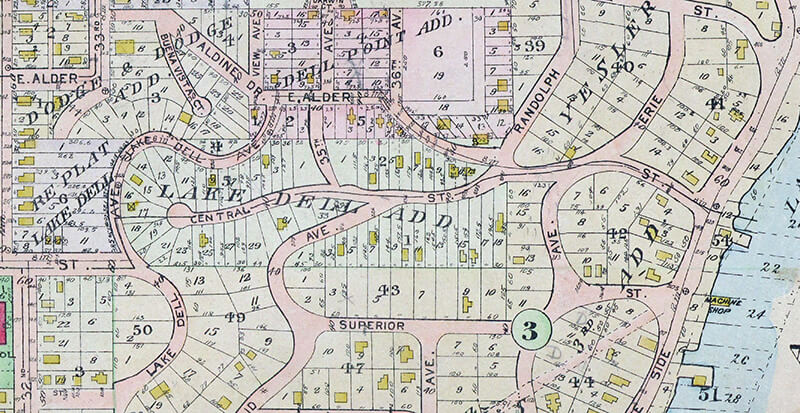
This street was created in 1890 as part of the Lake Dell Addition to the City of Seattle, the lake in question being Lake Washington, and the dell being the valley through which Lake Dell Avenue runs.
Lake Dell Avenue begins at 32nd Avenue just north of E Yesler Way and goes ⅓ of a mile to E Alder Street just west of 35th Avenue, forming part of the arterial connecting Yesler Way to Lakeside Avenue.
Portion of 1912 Baist real estate atlas of Seattle showing Lake Dell Addition
Landslide along Lake Dell Avenue, December 1933. Looking south from near the E Spruce Street right-of-way. Courtesy of the Seattle Municipal Archives, Identifier 8255
Lake Dell Avenue retaining wall, April 2012. Looking north from near the E Spruce Street right-of-way. Courtesy of the Seattle Municipal Archives, Identifier 174892
Born and raised in Seattle, Benjamin Donguk Lukoff had his interest in local history kindled at the age of six, when his father bought him settler granddaughter Sophie Frye Bass’s Pig-Tail Days in Old Seattle at the gift shop of the Museum of History and Industry. He studied English, Russian, and linguistics at the University of Washington, and went on to earn his master’s in English linguistics from University College London. His book of rephotography, Seattle Then and Now, was published in 2010. An updated version came out in 2015.
This street was created in 1895 as part of the plat of Seattle’s tide lands, which featured streets named for letters of the alphabet, American cities, American states, prominent local politicians, and places in Washington. Among the latter were S Spokane Street, Duwamish Avenue S, Klickitat Avenue SW, and our current subject, Chelan Avenue SW. It appears to have been named for Lake Chelan (an anglicization of ščəl̕ámxəxʷ, meaning ‘deep water’ in Nxaʔamxcín, the language spoken by the Chelan people) — the largest natural lake in Washington and the third deepest lake in the United States (after Crater and Tahoe).
Chelan Avenue SW begins at SW Spokane Street and goes ¼ mile northwest to the West Duwamish Waterway.
Born and raised in Seattle, Benjamin Donguk Lukoff had his interest in local history kindled at the age of six, when his father bought him settler granddaughter Sophie Frye Bass’s Pig-Tail Days in Old Seattle at the gift shop of the Museum of History and Industry. He studied English, Russian, and linguistics at the University of Washington, and went on to earn his master’s in English linguistics from University College London. His book of rephotography, Seattle Then and Now, was published in 2010. An updated version came out in 2015.
Streets in this plat that were not extensions of already existing ones, such as Commercial Street, were named after letters of the alphabet, American cities, American states, prominent local politicians, and places in Washington.
Those places in Washington were Chelan, Duwamish, Kitsap, Klickitat, Queets, Quilcene, Quileute, Quinault, Spokane, Vashon, Wenatchee, and Whatcom, many (though not all) of which were themselves named after Native American groups or people. (Chelan, Duwamish, Klickitat, and Spokane are the only street names that remain.) In this particular case, we have the Klickitat River, a tributary of the Columbia in south central Washington, itself named for the Klickitat people.
Klickitat Avenue SW begins at 16th Avenue SW and goes around ⅖ of a mile southeast to SW Manning Street, all on Harbor Island.
Born and raised in Seattle, Benjamin Donguk Lukoff had his interest in local history kindled at the age of six, when his father bought him settler granddaughter Sophie Frye Bass’s Pig-Tail Days in Old Seattle at the gift shop of the Museum of History and Industry. He studied English, Russian, and linguistics at the University of Washington, and went on to earn his master’s in English linguistics from University College London. His book of rephotography, Seattle Then and Now, was published in 2010. An updated version came out in 2015.
Ohio Avenue S begins at Diagonal Avenue S and goes nearly ½ a mile south to E Marginal Way S and S Dawson Street. It resumes ⅛ of a mile south of there at E Marginal Way S and S Brandon Street and goes a further ⅓ of a mile south to S Fidalgo Street.
Born and raised in Seattle, Benjamin Donguk Lukoff had his interest in local history kindled at the age of six, when his father bought him settler granddaughter Sophie Frye Bass’s Pig-Tail Days in Old Seattle at the gift shop of the Museum of History and Industry. He studied English, Russian, and linguistics at the University of Washington, and went on to earn his master’s in English linguistics from University College London. His book of rephotography, Seattle Then and Now, was published in 2010. An updated version came out in 2015.
This street was created in 1907 as part of the plat of Magnolia Park, filed by the Magnolia Park Company. Insurance man Ferdinand Bosher Edgerly (1881–1966), president of the company, lived most of his life in Manchester, New Hampshire, but according to his obituary moved to Seattle after graduating from Dartmouth College in 1904, returning to Manchester in 1913. It would appear he named Dartmouth Avenue after his alma mater.
Dartmouth Avenue W begins at the end of W Howe Street, just east of Magnolia Way W, and goes just under 300 feet southwest to rejoin Magnolia Way W. Almost all of it, however, functions as private driveways for a number of houses with Magnolia Way addresses; the initial paved portion is less than 75 feet long and serves the only house with a Dartmouth Avenue address.
Born and raised in Seattle, Benjamin Donguk Lukoff had his interest in local history kindled at the age of six, when his father bought him settler granddaughter Sophie Frye Bass’s Pig-Tail Days in Old Seattle at the gift shop of the Museum of History and Industry. He studied English, Russian, and linguistics at the University of Washington, and went on to earn his master’s in English linguistics from University College London. His book of rephotography, Seattle Then and Now, was published in 2010. An updated version came out in 2015.
As Seattle expanded to the south, it became obvious that Commercial Street (1st Avenue S) would not be the westernmost street east of Elliott Bay. Fortunately, instead of using zero or negative numbers, they went with states: the first street west of 1st was named Utah, and the next, Colorado. (Some perpendicular streets were named Alaska, Vermont, Connecticut, Texas, Massachusetts, etc. There doesn’t appear to have been any particular order.)
Utah Avenue S begins at S Atlantic Street and goes 1⅐ miles south to S Hinds Street, the block between S Stacy Street and S Lander Street, in front of the Starbucks Center, being closed to motorized traffic. There is another short segment between Denver Avenue S and S Alaska Street, and a final one that stretches ⅓ of a mile from S Hudson Street to S Findlay Street.
Born and raised in Seattle, Benjamin Donguk Lukoff had his interest in local history kindled at the age of six, when his father bought him settler granddaughter Sophie Frye Bass’s Pig-Tail Days in Old Seattle at the gift shop of the Museum of History and Industry. He studied English, Russian, and linguistics at the University of Washington, and went on to earn his master’s in English linguistics from University College London. His book of rephotography, Seattle Then and Now, was published in 2010. An updated version came out in 2015.
This street was created in 1895 as part of the Seattle Tide Lands plat. As I wrote in S Spokane Street, “Streets in this plat that were not extensions of already existing ones, such as Commercial Street, were named after letters of the alphabet, American cities, American states, prominent local politicians, and places in Washington”; these last included Chelan, Duwamish, Kitsap, Klickitat, Queets, Quilcene, Quileute, Quinault, Spokane, Vashon, Wenatchee, and Whatcom, the ones in italics still existing today. It seems strange to me that the Duwamish name would have been applied to such a short street, it being the name of Seattle’s principal river (dxwdəw) and indigenous inhabitants, the Duwamish Tribe (dxʷdəwʔabš), but there you have it. At least it still exists.
In “Elliott Way” just a placeholder name, I quote an email I wrote to the Seattle City Council and the Waterfront Seattle Program in December 2020 which read, in part, “I urge you… to name [Elliott Way] something else. The Duwamish people, for example, have Duwamish Avenue S named for them (actually more likely for the river…), but it is an insignificant street 2/10 of a mile long hidden under the Spokane Street Viaduct and the Alaskan Freeway. Perhaps Duwamish Avenue would be a better choice, if the tribe approved?” I still think this would be a good idea (and it would give us another naming opportunity as well). They did respond favorably, said they had been thinking along the same lines, and as of January 2022 “continue to coordinate with the tribes and other partners on a proposed name.” I hope they come up with something soon, as what is still being referred to as Elliott Way is due to open by year’s end!
As I mentioned in my email, Duwamish Avenue S is 2/10 of a mile long, beginning at E Marginal Way S and ending at a Port of Seattle road just south of the West Seattle and Spokane Street Bridges.
Update as of February 2, 2023: I posted an article last month —“Dzidzilalich” to be honorary name for Elliott Way, Alaskan Way — noting that, in fact, the roadway will be known as Elliott Way… but will carry the honorary name “Dzidzilalich.” So it seems “Elliott Way,” after all, is unfortunately not just a placeholder name, and for now the Duwamish name remains confined to this obscure thousand-foot-long street.
Portion of 1895 plat of Seattle Tide Lands showing Duwamish Avenue, as platted from Spokane Avenue (now Street) in the northwest to Seattle Boulevard in the southeast. The visible portion of Seattle Boulevard is now Diagonal Avenue S, Whatcom Avenue is now E Marginal Way S, and Grant Street is now Airport Way S.
Born and raised in Seattle, Benjamin Donguk Lukoff had his interest in local history kindled at the age of six, when his father bought him settler granddaughter Sophie Frye Bass’s Pig-Tail Days in Old Seattle at the gift shop of the Museum of History and Industry. He studied English, Russian, and linguistics at the University of Washington, and went on to earn his master’s in English linguistics from University College London. His book of rephotography, Seattle Then and Now, was published in 2010. An updated version came out in 2015.
This street is named for William Ashworth (1840–1906). According to the Haller Lake Community Club, Ashworth was born in England, emigrated to the United States in 1861, and came to Seattle in 1872.
Ashworth platted a town called Edgewater on the northern shore of Lake Union.… This area is now roughly the eastern part of Fremont and western portion of Wallingford.… Ashworth served as Edgewater’s only postmaster from 1889 until the area was annexed to Seattle two years later. As real estate development moved northward, so did the street bearing Ashworth’s name. Ashworth continued to live in Edgewater until his death in 1906.
Here is an article by local historian Paul Dorpat on Edgewater, on which it looks like I commented 13 years ago. And we learn both from the HLCC and Valarie Bunn of Wedgwood in Seattle History that the land on which berry farmer Ashworth’s home once stood is now the North Transfer Station (i.e., the city dump).
Today, Ashworth Avenue N begins at N 35th Street and goes ⅔ of a mile north to N 43rd Street. It resumes at N 55th Street and goes ¼ mile north to E Green Lake Way N, then begins again on the north side of the lake at Winona Avenue N and W Green Lake Drive N. From here, it goes another ⅔ of a mile to N 90th Street. Picking up again at N 92nd Street, it goes a further ⅞ of a mile to the Evergreen Washelli Cemetery at N 110th Street. It resumes one more time at N 120th Street and Stendall Drive N and goes 1¼ miles north to the city limits at N 145th Street, becoming a footpath for two short stretches west of Haller Lake. (As with many other North Seattle avenues, the name continues on into Shoreline; Ashworth Avenue N continues north of the city limits as far as N 200th Street, just south of the King–Snohomish county line at N 205th Street.)
Born and raised in Seattle, Benjamin Donguk Lukoff had his interest in local history kindled at the age of six, when his father bought him settler granddaughter Sophie Frye Bass’s Pig-Tail Days in Old Seattle at the gift shop of the Museum of History and Industry. He studied English, Russian, and linguistics at the University of Washington, and went on to earn his master’s in English linguistics from University College London. His book of rephotography, Seattle Then and Now, was published in 2010. An updated version came out in 2015.
This street, created in 1890 as part of the plat of the Denny-Fuhrman Addition to the City of Seattle, was originally named Randall Street. I haven’t been able to pinpoint the reason for or date of the name change, but it first appears in The Seattle Times and in the city’s ordinances in 1906. The street and addition were named for Henry Fuhrman (1843–1907), who developed the area with David Thomas Denny (1832–1903) (Denny Way).
Fuhrman, who had come to Seattle in 1890, was a German Jew. According to his Seattle Times obituary, he “came to this country from Germany when a boy.… He was engaged as a mercantile solicitor in the early days, but later started a small drygoods business in Fremont, Nebraska, where he has since become famous as the pioneer wholesale drygoods merchant west of Omaha.… It is estimated that his fortune amounts to at least a million dollars.”
Fuhrman and Charles Cowen (né Cohen) (1869–1926) (Cowen Place NE) are the only Jews I am aware of who have Seattle streets named after them. (Note added November 9, 2024: Now there’s a third: Sue Bird [born 1980] [Sue Bird Court N]).
Henry Fuhrman, from his Seattle Times obituary, August 23, 1907
Fuhrman Avenue E begins at the north end of Fairview Avenue E, under the Ship Canal Bridge, and goes nearly ½ a mile southeast to E Shelby Street, where it becomes Boyer Avenue E. (A short segment begins about 150 feet to the east of Boyer, heads about 225 feet to the south, and mainly functions as a driveway for a number of houseboats; and another short segment begins at the north end of 15th Avenue E at the E Calhoun Street pathway, heads about 275 feet to the northeast, and serves as a driveway for an apartment complex.)
Born and raised in Seattle, Benjamin Donguk Lukoff had his interest in local history kindled at the age of six, when his father bought him settler granddaughter Sophie Frye Bass’s Pig-Tail Days in Old Seattle at the gift shop of the Museum of History and Industry. He studied English, Russian, and linguistics at the University of Washington, and went on to earn his master’s in English linguistics from University College London. His book of rephotography, Seattle Then and Now, was published in 2010. An updated version came out in 2015.
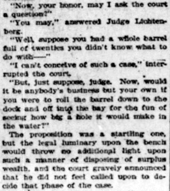
Wetmore “founded Seattle’s first tannery and shoe making business in 1855” with Milton Daniel Woodin (1800–1869), who was the father of his wife, Ann Woodin Wetmore (1829–1886). (Woodinville, located northeast of Seattle along the Sammamish River, was named after the Woodin family.) He homesteaded land in Rainier Valley, which later became the subject of a lawsuit against him by all his children except Jane. As the Seattle Post-Intelligencer reported on September 17, 1892,
Seymour Wetmore is an old settler in this section, who took up a government claim of 160 acres of land, which lies across the present line of the Rainier avenue electric railway. With the growth of Seattle Wetmore, by the increase of the values of property, found himself quite a wealthy man.… After the death of his wife her share was divided among the seven children, each of whom received $5,500. The amount that the father has kept for himself is now valued at about $25,000.… Last July a petition was filed… asking for the appointment of a guardian for Seymour Wetmore, on the ground that he was an habitual drunkard and incapable of taking care of himself.… The eldest son… swore to the petition, which set out that the father was addicted to dangerous excess in the use of intoxicating liquors, and was in the habit of going around in the company of lewd women and squandering his money.… [Wetmore] admitted that he drank. He had always been a drinking man and always would be. But he indignantly denied the charges that he associated with lewd women. By his answers he intimated that the… proceedings were due to a desire on the part of the children to tie up his property so that they would be sure of it in case of his death.
Finally, in February 1895, the matter was settled, as the Post-Intelligencer reported on the 28th under the headline ‘Seymour Wetmore Will Be Free to Squander His Wealth — He only yearns to spend it’. The article first recapped the origin of the lawsuit:
He felt as rich as any of the lords of creation, and worked himself up to the intoxication of enjoyment by spending money for the sole pleasure of seeing it go. He went about, his pockets lined with $20 pieces. This sort of thing grew tiresome to his prospective heirs, who became desperate on learning that Wetmore had entered into a deal with Byron Young, of Tacoma, whereby the latter received, in return for a bauble, $8,000 in money and 50 lots in Byron addition.
Excerpt from Seattle Post-Intelligencer article, from February 28, 1895, issue on Seymour Wetmore’s guardianship case, in which Wetmore argues for his right to do whatever he wants with his money, including destroying it
The case dragged on for a while, but, as it turns out,
Pending the decision of the supreme court the property involved had been transferred and retransferred again and again until an abstract of title would make a formidable document. In consequence the case of [Wetmore’s guardian] vs. Young was dismissed by stipulation in the equity department last Saturday. There is now nothing left to fight over, and the inevitable conclusion is that the aged ward will be found able to take care of himself.
Wetmore Avenue S begins at 30th Avenue S just south of S Hanford Street, crosses S Byron Street, and goes 800 feet southeast to S Walden Street. There is another short segment — around 150 feet long — south of S Estelle Street, which turns into a footpath of about equal length connecting to S Spokane Street.
Born and raised in Seattle, Benjamin Donguk Lukoff had his interest in local history kindled at the age of six, when his father bought him settler granddaughter Sophie Frye Bass’s Pig-Tail Days in Old Seattle at the gift shop of the Museum of History and Industry. He studied English, Russian, and linguistics at the University of Washington, and went on to earn his master’s in English linguistics from University College London. His book of rephotography, Seattle Then and Now, was published in 2010. An updated version came out in 2015.
This street follows the route of the Rainier Avenue Electric Railway Company’s Seattle-to-Renton line, which began to be built in 1891. Both the rail line and street were named for Mount Rainier (təqʷubəʔ), itself named by Captain George Vancouver for his friend, Royal Navy Rear Admiral Peter Rainier (1741–1808). As the Seattle Post-Intelligencer noted on September 3, 1890, “the avenue points straight toward Mount Rainier, which mountain will be in plain view all the way.”
Rainier Avenue S begins at the intersection of S Jackson Street, Boren Avenue S, and 14th Avenue S, and goes nearly 8 miles southeast to the city limits. From there, it continues around 3¾ miles south to the intersection of Interstate 405 and State Route 167 in Renton.
Aerial view of Rainier Valley, Beacon Hill, and Downtown, May 22, 2001. Rainier Avenue S is the tree-lined street running up the middle of the photograph. Courtesy of the Seattle Municipal Archives, Identifier 114373.
Born and raised in Seattle, Benjamin Donguk Lukoff had his interest in local history kindled at the age of six, when his father bought him settler granddaughter Sophie Frye Bass’s Pig-Tail Days in Old Seattle at the gift shop of the Museum of History and Industry. He studied English, Russian, and linguistics at the University of Washington, and went on to earn his master’s in English linguistics from University College London. His book of rephotography, Seattle Then and Now, was published in 2010. An updated version came out in 2015.
Born and raised in Seattle, Benjamin Donguk Lukoff had his interest in local history kindled at the age of six, when his father bought him settler granddaughter Sophie Frye Bass’s Pig-Tail Days in Old Seattle at the gift shop of the Museum of History and Industry. He studied English, Russian, and linguistics at the University of Washington, and went on to earn his master’s in English linguistics from University College London. His book of rephotography, Seattle Then and Now, was published in 2010. An updated version came out in 2015.
I first came across the Alki History Project while doing research for my article on SW Bronson Way. I’m not sure how I missed it before. The paper that mentioned Ira Bronson was “If at First You Don’t Succeed…,” a fascinating history of municipal governance and elections in West Seattle, and when I looked at their list of other papers I was thrilled to see among them “What’s in a Name?” — an investigation of Alki street names, both current and those changed long ago. Frater Avenue SW is the first of a number of posts in which I will be citing this paper, written by Phillip H. Hoffman, director of the project.
Frater Avenue SW originates in the 1955 plat of Anderson’s Soundview Terrace Addition № 2. Why Anderson, Caple, or Knowlton weren’t chosen instead for the honor (this being the only new street in the small subdivision, and those being the surnames of the three couples who filed the plat) isn’t clear. But, as Hoffman notes, SW Frater Street and SW Frater Place (both of which have since been vacated) were just to the west in the adjacent plat. In addition, an earlier Frater Avenue SW had existed, until it was vacated in 1942, just southeast of where today’s Frater Avenue begins at SW Spokane Street. The current Frater Avenue must have been named after one of these three streets.
But, of course, that leaves the question of who those three streets initially honored, and according to Hoffman,
Frater Avenue first appears in the plat Partition of Crawford Tract as ordered in King County Superior Court, Cause № 64110, June 17, 1915. [A.W.] Frater was the presiding judge.… The court commissioners assisting in the adjudication of a land title and ownership dispute before Judge Frater that resulted in the Crawford Tract plat probably named Frater Avenue in 1915, along with all the other streets appearing in the plat.
Archibald Wanless Frater (1856–1925), according to Cornelius Holgate in Seattle and Environs, was born in Ohio and came to Washington in 1888. Initially settling in Tacoma, he moved to Snohomish the next year and came to Seattle in 1898.
Judge Archibald Wanless Frater, from the front cover of The Seattle Mail & Herald, June 3, 1905
Today’s Frater Avenue SW begins at 57th Avenue SW just north of SW Hinds Street and goes ⅛ of a mile southeast to SW Spokane Street just west of 56th Avenue SW.
Born and raised in Seattle, Benjamin Donguk Lukoff had his interest in local history kindled at the age of six, when his father bought him settler granddaughter Sophie Frye Bass’s Pig-Tail Days in Old Seattle at the gift shop of the Museum of History and Industry. He studied English, Russian, and linguistics at the University of Washington, and went on to earn his master’s in English linguistics from University College London. His book of rephotography, Seattle Then and Now, was published in 2010. An updated version came out in 2015.
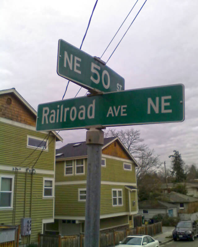
This street was created in 1946 by Ordinance 75507, “an ordinance accepting a deed from Eva M. Barquist, a spinster, to the City of Seattle for street purposes and laying off East 50th Street and Railroad Avenue Northeast.” This restored the Railroad Avenue NE name to a very short street on the east side of the Northern Pacific tracks, six years after it was changed to NE Blakely Street on the west side.
Railroad Avenue NE begins at NE 50th Street just east of 39th Avenue NE and goes 90 feet south to a dead end, essentially serving as a driveway for a cluster of townhouses.
Born and raised in Seattle, Benjamin Donguk Lukoff had his interest in local history kindled at the age of six, when his father bought him settler granddaughter Sophie Frye Bass’s Pig-Tail Days in Old Seattle at the gift shop of the Museum of History and Industry. He studied English, Russian, and linguistics at the University of Washington, and went on to earn his master’s in English linguistics from University College London. His book of rephotography, Seattle Then and Now, was published in 2010. An updated version came out in 2015.
This street, like most others in Fort Lawton (1900−2011), which is now Discovery Park, was named by the United States Army after a state of the Union. I am not sure when the post’s streets were so named or who made the decision, but it can have been no later than 1944, when this map was made by the Army Corps of Engineers. (Here’s a much higher-resolution version from the Seattle Municipal Archives, created in 1973 but based on the older map.) One can see there that what are today Illinois Avenue and Bernie Whitebear Way were originally Vermont Way, Illinois Street, Lawton Road, and Florida Avenue. At some point before 1967 (see this map made by the Fort Lawton Office of the Post Engineer) the four were combined, and in 2011 the middle portion was renamed after Native American activist Bernie Whitebear.
Today, the eastern section of Illinois Avenue begins at Discovery Park Boulevard and goes ¼ of a mile north to Texas Way, where it turns into Bernie Whitebear Way. (Except for 45th Avenue W, no street in Discovery Park carries directional designations, nor did they when it was still a fort.) The western section, which is closed to traffic, begins at Texas Way and Discovery Park Boulevard and goes ¼ mile north to connect with footpaths that themselves connect to the North Beach Trail.
Born and raised in Seattle, Benjamin Donguk Lukoff had his interest in local history kindled at the age of six, when his father bought him settler granddaughter Sophie Frye Bass’s Pig-Tail Days in Old Seattle at the gift shop of the Museum of History and Industry. He studied English, Russian, and linguistics at the University of Washington, and went on to earn his master’s in English linguistics from University College London. His book of rephotography, Seattle Then and Now, was published in 2010. An updated version came out in 2015.
This street first appeared in 1890 as part of Yesler’s Third Addition to the City of Seattle, and ran two blocks from what is now E Alder Street to the north end of what is now Leschi Park. It was so named for running along the Lake Washington shoreline.
Today, Lakeside Avenue begins a block further south, where Lake Washington Boulevard leaves the shoreline and begins winding its way through Leschi and Frink Parks. It becomes Lakeside Avenue S at the north end of Leschi Park, and ends where Lake Washington Boulevard S rejoins the shoreline at Colman Beach, for a total distance of 1¼ miles.
Born and raised in Seattle, Benjamin Donguk Lukoff had his interest in local history kindled at the age of six, when his father bought him settler granddaughter Sophie Frye Bass’s Pig-Tail Days in Old Seattle at the gift shop of the Museum of History and Industry. He studied English, Russian, and linguistics at the University of Washington, and went on to earn his master’s in English linguistics from University College London. His book of rephotography, Seattle Then and Now, was published in 2010. An updated version came out in 2015.
This street, created in 1888 as part of the First Plat of West Seattle by the West Seattle Land and Improvement Company, was originally named Grand Avenue. It was renamed, along with many other West Seattle streets, in 1907, when West Seattle was annexed by Seattle. The name was a reference to the WSL&IC ferry terminal at what is today Harbor Avenue SW at California Way SW. The West Seattle Water Taxi has been operating from the same location since 1997.
Today, Ferry Avenue SW begins at California Way SW and goes about ³⁄₇ of a mile southwest to just past California Avenue SW, at California Place park (built on the site of a former streetcar terminal; before that, a cable car ran up the Ferry Avenue right-of-way from Elliott Bay to this location). It resumes on the other side of the park at SW Hill Street and goes a further 600 feet southwest to SW Walker Street.
Born and raised in Seattle, Benjamin Donguk Lukoff had his interest in local history kindled at the age of six, when his father bought him settler granddaughter Sophie Frye Bass’s Pig-Tail Days in Old Seattle at the gift shop of the Museum of History and Industry. He studied English, Russian, and linguistics at the University of Washington, and went on to earn his master’s in English linguistics from University College London. His book of rephotography, Seattle Then and Now, was published in 2010. An updated version came out in 2015.


