This street, created in 1931, was almost certainly named for Camano Island (known as ʔəw̓alus in Lushootseed), which is located, as Wikipedia tells us, in Puget Sound “between Whidbey Island and the mainland… by the Saratoga Passage to the west and Port Susan and Davis Slough to the east.” The timeline of its naming:
The strait connecting Puget Sound to the Strait of Juan de Fuca was named Ensenada de Caamaño by the Quimper Expedition in 1790. Jacinto Caamaño Moraleja was a fellow Spanish explorer of the Pacific Northwest.
ʔəw̓alus was named Macdonough Island by the Wilkes Expedition in 1841.
In 1847, Vice Admiral Sir Henry Kellett of the Royal Navy resurrected the Camano name (after having altered its spelling) and applied it to Macdonough Island.
S Camano Place begins at Renton Avenue S between S Thistle Street and S Cloverdale Street and goes 425 east to a cul-de-sac.
Born and raised in Seattle, Benjamin Donguk Lukoff had his interest in local history kindled at the age of six, when his father bought him settler granddaughter Sophie Frye Bass’s Pig-Tail Days in Old Seattle at the gift shop of the Museum of History and Industry. He studied English, Russian, and linguistics at the University of Washington, and went on to earn his master’s in English linguistics from University College London. His book of rephotography, Seattle Then and Now, was published in 2010. An updated version came out in 2015.
Only a few years after the bill’s 1902 passage, however, Maxwell became a staunch critic of its Bureau of Reclamation, which, much to his chagrin, rapidly devolved from a “welfare agency” to a “construction agency,” for which building dams, rather than reaping social benefits, became the ultimate goal. Agribusinessmen, land developers, and municipal leaders who had little interest in or stomach for Edenic visions of family-farm communities increasingly manipulated the region’s water resources. Maxwell became obsessed with the thought that these hydraulic projects deprioritized the needs of the urban poor.
He therefore formed the American Homecroft Society in 1907, which “aimed to reclaim small vacant lots and back alleys rather than millions of acres of arid lands. It encouraged wageworkers to become competent backyard gardeners rather than yeoman farmers.”
Maxwell proffered homecrofts as the antidote to major crises confronting urban America. In addition to mending industrial workers’ severed relationship with nature, homes that incorporated spaces for production, to Maxwell’s mind, granted working-class families autonomy and supplemental income in a volatile market. They stymied a mass market bent on transforming suburban homes into shallow spaces of conspicuous consumption.
Homecroft advertisement, The Seattle Times, June 20, 1920, page 11
However, as this 1936 aerial photo of the area shows, most of the land remained vacant. (For reference, the two prominent north–south streets are 21st and 16th Avenues SW; the long diagonal at left is Croft Place SW; and the diagonal in the southwest corner is Delridge Way SW [originally McKinnon Way SW].) I’m sure the Great Depression did not help matters. In addition, the Puget Creek Greenspace occupies much of the land between 18th and 21st Avenues SW. Today, the entire neighborhood is residential, with nary a farm in sight, if indeed any were ever built.
Croft Place SW exists in two segments. One runs ¼ of a mile southeast from the intersection of SW Juneau Street and 23rd Avenue SW, just north of the Louisa Boren STEM K-8 School campus, to 21st Avenue SW just north of its intersection with SW Graham Street. The other is essentially a driveway that runs around 175 feet northeast from Delridge Way SW between SW Myrtle Street and SW Willow Street, although the undeveloped right-of-way extends 625 feet further, to the intersection of SW Holly Street and 21st Avenue SW.
Homecroft advertisement, The Seattle Times, June 17, 1920, page 15. See the full PDF.
Born and raised in Seattle, Benjamin Donguk Lukoff had his interest in local history kindled at the age of six, when his father bought him settler granddaughter Sophie Frye Bass’s Pig-Tail Days in Old Seattle at the gift shop of the Museum of History and Industry. He studied English, Russian, and linguistics at the University of Washington, and went on to earn his master’s in English linguistics from University College London. His book of rephotography, Seattle Then and Now, was published in 2010. An updated version came out in 2015.
This short Montlake street, which runs just over 150 feet from E Roanoke Street between 24th and 25th Avenues E in the south to the alley to the north, was created in 1925 as part of the plat of Glenwilde, an Addition to the City of Seattle, filed by E.F. Barnum and his wife, Sarah Barnum, and named for that subdivision.
Glenwilde Addition advertisement on page 20 of the March 10, 1926, edition of The Seattle Times
Born and raised in Seattle, Benjamin Donguk Lukoff had his interest in local history kindled at the age of six, when his father bought him settler granddaughter Sophie Frye Bass’s Pig-Tail Days in Old Seattle at the gift shop of the Museum of History and Industry. He studied English, Russian, and linguistics at the University of Washington, and went on to earn his master’s in English linguistics from University College London. His book of rephotography, Seattle Then and Now, was published in 2010. An updated version came out in 2015.
This street was created in two stages: the southern portion of this street in 1971 as 25th Avenue S, part of the plat of Beacon Vista; the northern portion in 1976, part of Goodwin’s Addition. A year before the second plat was filed, its name was changed to Vista Avenue S, obviously after the initial plat.
Beacon Vista itself was named for its view from Beacon Hill, not of Beacon Hill:
Today, Vista Avenue S begins at S Willow Street between Mars Avenue S and Beacon Avenue S, and goes 800 feet north to S Holly Street west of Beacon Avenue S.
Born and raised in Seattle, Benjamin Donguk Lukoff had his interest in local history kindled at the age of six, when his father bought him settler granddaughter Sophie Frye Bass’s Pig-Tail Days in Old Seattle at the gift shop of the Museum of History and Industry. He studied English, Russian, and linguistics at the University of Washington, and went on to earn his master’s in English linguistics from University College London. His book of rephotography, Seattle Then and Now, was published in 2010. An updated version came out in 2015.
This unnamed street, which was built sometime between 2002 and 2005, received a name in 2016 as part of a bill to improve emergency wayfinding, Ordinance 125106, which dealt with a number of other street name changes as well. It was named, of course, for Eastlake Avenue NE (the University Bridge), in whose right-of-way it was built. The bill summary provides details:
Name change of a lower roadway at the east of the present existing bridge on Eastlake Avenue NE between its south terminus at the shoreline and the south margin of NE Pacific Street to Eastlake Place NE: In 2010, this portion of Eastlake Avenue NE was informally renamed as Eastlake Place NE in 2010 by SDOT but it was not legally renamed by ordinance. This action will formally name the segment by ordinance. It is necessary to legally name this segment to get the name to properly present on mapping tools pulling from Street Network Database and SDOT’s asset management program, Hansen 8. Not showing the correct name is causing internal SDOT confusion. The University of Washington also needs to officially address facilities off of this segment and DPD cannot proceed until the name is changed. (Also relevant to new segment in Eastlake r/w north of Pacific; see below). SDOT sign records notes this intersection signed as Eastlake Avenue NE in 2004, however no notation prior. Per orthophotos, the Eastlake right-of-way under the University Bridge was built to its current configuration between 2002 and 2005, potentially as part of the new building construction for 905 Boat Street.
Naming a lower roadway at the east of the present existing bridge on Eastlake Ave NE between the north margin of NE Pacific Street and the south margin of NE 40th Street to Eastlake Place NE: Names this newly constructed segment Eastlake Place NE to agree with segment to the south.
Eastlake Place NE begins on the Lake Union shoreline south of NE Pacific Street and goes around 500 feet northeast to the Burke-Gilman Trail, the last 160 or so feet being a pathway.
Born and raised in Seattle, Benjamin Donguk Lukoff had his interest in local history kindled at the age of six, when his father bought him settler granddaughter Sophie Frye Bass’s Pig-Tail Days in Old Seattle at the gift shop of the Museum of History and Industry. He studied English, Russian, and linguistics at the University of Washington, and went on to earn his master’s in English linguistics from University College London. His book of rephotography, Seattle Then and Now, was published in 2010. An updated version came out in 2015.
This Queen Anne street was established in 1923 as Lee Place and received its current name in 1924. It was likely named for the Queen Anne Standpipes, a pair of water towers nearby that were built in 1900 and 1901 and served the neighborhood until 2007. Even though they were historical landmarks, they were subsequently demolished and replaced with the current single tower.
Interestingly, though its lack of a directional designation (e.g., Tower Place N) would imply it’s an east–west street, the quarter section map appears to indicate it’s both, beginning at Lee Street just south of Observatory Courts and going 175 feet south to a dead end, and beginning halfway down the aforementioned segment and going around 100 feet east to a dead end.
An “early 20th century,” according to Paul Dorpat, postcard of the water towers and adjacent fire station
Born and raised in Seattle, Benjamin Donguk Lukoff had his interest in local history kindled at the age of six, when his father bought him settler granddaughter Sophie Frye Bass’s Pig-Tail Days in Old Seattle at the gift shop of the Museum of History and Industry. He studied English, Russian, and linguistics at the University of Washington, and went on to earn his master’s in English linguistics from University College London. His book of rephotography, Seattle Then and Now, was published in 2010. An updated version came out in 2015.
Born and raised in Seattle, Benjamin Donguk Lukoff had his interest in local history kindled at the age of six, when his father bought him settler granddaughter Sophie Frye Bass’s Pig-Tail Days in Old Seattle at the gift shop of the Museum of History and Industry. He studied English, Russian, and linguistics at the University of Washington, and went on to earn his master’s in English linguistics from University College London. His book of rephotography, Seattle Then and Now, was published in 2010. An updated version came out in 2015.
Born and raised in Seattle, Benjamin Donguk Lukoff had his interest in local history kindled at the age of six, when his father bought him settler granddaughter Sophie Frye Bass’s Pig-Tail Days in Old Seattle at the gift shop of the Museum of History and Industry. He studied English, Russian, and linguistics at the University of Washington, and went on to earn his master’s in English linguistics from University College London. His book of rephotography, Seattle Then and Now, was published in 2010. An updated version came out in 2015.
This street was created in 1906 as part of the plat of Seaside Addition, a Replat of Part of Lot 2, Alki Point, filed by William Holt (who was, among other things, proprietor of the Grand Central Hotel in Pioneer Square). He passed away nine years later, as noted in this story from the front page of the November 18, 1915, issue of The Seattle Star. Running just over 450 feet south from Alki Avenue SW to SW Lander Street, between 58th and 59th Avenues SW, it would seem to be a reasonable assumption that it was so named for its close proximity to the waterfront.
Born and raised in Seattle, Benjamin Donguk Lukoff had his interest in local history kindled at the age of six, when his father bought him settler granddaughter Sophie Frye Bass’s Pig-Tail Days in Old Seattle at the gift shop of the Museum of History and Industry. He studied English, Russian, and linguistics at the University of Washington, and went on to earn his master’s in English linguistics from University College London. His book of rephotography, Seattle Then and Now, was published in 2010. An updated version came out in 2015.
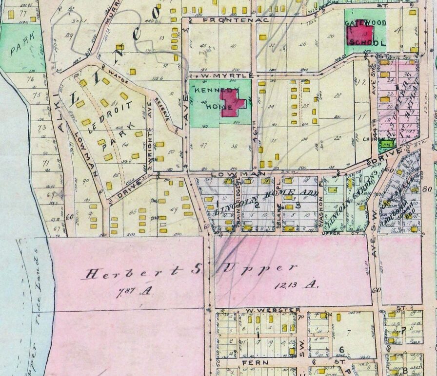
This West Seattle street was created as part of the plat of Woodside, an Addition to the City of Seattle, filed on June 17, 1919, by Eugene E. Harold, and named for the subdivision. I don’t think it’s too much of a stretch to assume the subdivision was so named because of its proximity to the wooded area that is now Lincoln Park.
Woodside Place SW begins at SW Myrtle Street just south of Gatewood Elementary School and goes just over 600 feet south to SW Othello Street.
Detail of 1912 Baist atlas of Seattle showing current location of Woodside Place, south of W Myrtle Street (now SW Myrtle Street) just southwest of Gatewood Elementary School. The vacant land shaded in pink as and noted as belonging to Herbert S. Upper is now part of Lincoln Park (along Puget Sound) and Solstice Park, formerly Lincoln Park Annex (to the east, between what are now Fauntleroy Way SW and 44th Avenue SW).
Born and raised in Seattle, Benjamin Donguk Lukoff had his interest in local history kindled at the age of six, when his father bought him settler granddaughter Sophie Frye Bass’s Pig-Tail Days in Old Seattle at the gift shop of the Museum of History and Industry. He studied English, Russian, and linguistics at the University of Washington, and went on to earn his master’s in English linguistics from University College London. His book of rephotography, Seattle Then and Now, was published in 2010. An updated version came out in 2015.
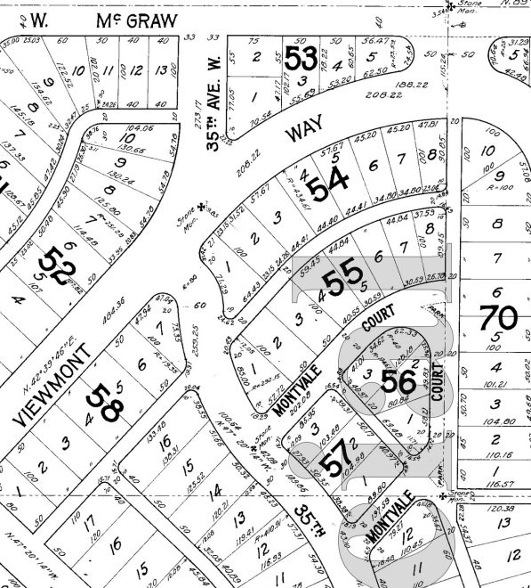
What is now Montvale Place W was originally Montvale Court W, created in 1915 as part of the plat of Carleton Park. When originally platted, Montvale Court formed a horseshoe-shaped loop, but at some point (the quarter section map doesn’t say, and I can find no relevant city ordinance), the eastern and southeastern part of the street, plus the alley connecting to 34th Avenue W, was renamed Montvale Place W.
Montvale Place W begins at 35th Avenue W south of Montvale Court W and goes ⅛ of a mile northeast, then north, to the intersection of Viewmont Way W, 34th Avenue W, and W Lynn Street.
Portion of plat of Carleton Park showing original course of Montvale Court W, over half of which is now Montvale Place W
Born and raised in Seattle, Benjamin Donguk Lukoff had his interest in local history kindled at the age of six, when his father bought him settler granddaughter Sophie Frye Bass’s Pig-Tail Days in Old Seattle at the gift shop of the Museum of History and Industry. He studied English, Russian, and linguistics at the University of Washington, and went on to earn his master’s in English linguistics from University College London. His book of rephotography, Seattle Then and Now, was published in 2010. An updated version came out in 2015.
Montvale Court W begins at 35th Avenue W south of Viewmont Way W and goes just over 300 feet northeast to Montvale Place W. (When it was originally platted, it formed a horseshoe-shaped loop back to 35th, but at some point the eastern and southeastern part of the street was renamed Montvale Place W.)
Portion of plat of Carleton Park showing original course of Montvale Court W
Born and raised in Seattle, Benjamin Donguk Lukoff had his interest in local history kindled at the age of six, when his father bought him settler granddaughter Sophie Frye Bass’s Pig-Tail Days in Old Seattle at the gift shop of the Museum of History and Industry. He studied English, Russian, and linguistics at the University of Washington, and went on to earn his master’s in English linguistics from University College London. His book of rephotography, Seattle Then and Now, was published in 2010. An updated version came out in 2015.
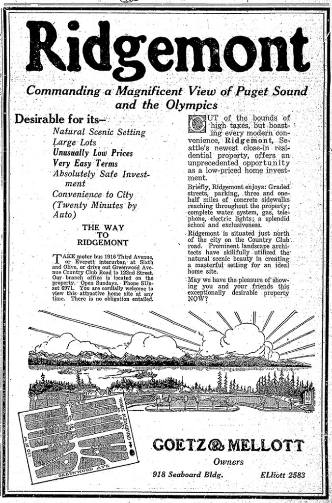
This street was created in 1925 as part of the plat of Ridgemont. Unnamed at the time, it was presumably later named after the subdivision. I say “presumably” because there is no record of its being named in Seattle’s online legislative database, which there should be if this was done after this part of town was annexed in 1953, and King County’s only goes back to 1969.
Ridgemont, as the below advertisement implies, was named for its location atop a ridge “commanding a magnificent view of Puget Sound and the Olympics.”
Ridgemont Way N begins at Greenwood Avenue N just south of N 125th Street and goes just over 425 feet southwest to N 122nd Street.
Advertisement for the Ridegmont subdivision, The Seattle Times, October 11, 1925. It would remain outside of the city and “out of the bounds of high taxes” for 28 years.
Born and raised in Seattle, Benjamin Donguk Lukoff had his interest in local history kindled at the age of six, when his father bought him settler granddaughter Sophie Frye Bass’s Pig-Tail Days in Old Seattle at the gift shop of the Museum of History and Industry. He studied English, Russian, and linguistics at the University of Washington, and went on to earn his master’s in English linguistics from University College London. His book of rephotography, Seattle Then and Now, was published in 2010. An updated version came out in 2015.
This street, like NW Culbertson Drive, was created in 1955 as part of the plat of Llandover-by-the-Sound, and was presumably named for the property’s view of the Olympic Mountains to the west. (I say property, singular, because there is only one house with an Alpine Way address).
Alpine Way NW begins at NW Culbertson Drive and goes just over 325 feet south to NW Northwood Road.
Born and raised in Seattle, Benjamin Donguk Lukoff had his interest in local history kindled at the age of six, when his father bought him settler granddaughter Sophie Frye Bass’s Pig-Tail Days in Old Seattle at the gift shop of the Museum of History and Industry. He studied English, Russian, and linguistics at the University of Washington, and went on to earn his master’s in English linguistics from University College London. His book of rephotography, Seattle Then and Now, was published in 2010. An updated version came out in 2015.
This private street begins at 2nd Avenue S and S King Street and goes 300 feet south to the north parking lot of Lumen Field. It was created in 2011 as part of the Stadium Place development, after which it was named. The development, in turn, was so named for its proximity to Lumen Field, known as Seahawks Stadium from 2002 to 2004, Qwest Field from 2004 to 2011, and CenturyLink Field from 2011 to 2020.
Born and raised in Seattle, Benjamin Donguk Lukoff had his interest in local history kindled at the age of six, when his father bought him settler granddaughter Sophie Frye Bass’s Pig-Tail Days in Old Seattle at the gift shop of the Museum of History and Industry. He studied English, Russian, and linguistics at the University of Washington, and went on to earn his master’s in English linguistics from University College London. His book of rephotography, Seattle Then and Now, was published in 2010. An updated version came out in 2015.
This street was created in 1966 as Union Place, a state-owned frontage road for the recently constructed Interstate 5. (Construction of an earlier, nearby Union Place had been approved and then repealed in 1902.) It was renamed Convention Place in 1988 when the city took ownership as part of the construction of the Washington State Convention Center, which became the Seattle Convention Center in 2022.
Formerly open to the air, Convention Place became a tunnel during the construction of the convention center, which was built over it and Interstate 5. It begins at the intersection of 9th Avenue and Pike Street and goes ⅛ of a mile southwest to Union Street just before its intersection with 7th Avenue.
Looking south from the I-5 Pine Street overpass toward Pike Street and the Convention Center, June 2015. The Paramount Theatre is just visible at far right, and just to the left of that, at 9th Avenue and Pike Street, is where Convention Place begins. Photograph by Flickr user SounderBruce, licensed under Creative Commons Attribution-ShareAlike 2.0 Generic
Born and raised in Seattle, Benjamin Donguk Lukoff had his interest in local history kindled at the age of six, when his father bought him settler granddaughter Sophie Frye Bass’s Pig-Tail Days in Old Seattle at the gift shop of the Museum of History and Industry. He studied English, Russian, and linguistics at the University of Washington, and went on to earn his master’s in English linguistics from University College London. His book of rephotography, Seattle Then and Now, was published in 2010. An updated version came out in 2015.
This street was created in 1905 as part of the plat of the Sound View Addition to Queen Anne. Originally a loop off 11th Avenue W and carrying that name, at some point it was renamed after the addition — which itself was named for its fine view of Puget Sound. (I have been unable to find the renaming ordinance, so don’t know exactly when the change was made.)
Smith Cove, Interbay, and Magnolia from Soundview Terrace Park, July 2008. The industrial area at center is the Port of Seattle’s Terminal 91, the BNSF Railway’s Balmer Yard, and the Washington National Guard’s Seattle Readiness Center. Beyond the Magnolia Bridge is the Elliott Bay Marina. Photograph by Joe Mabel, Wikimedia Commons, licensed under Creative Commons Attribution-Share Alike 3.0 Unported
Soundview Terrace Playground, July 2015. Sound View Terrace W is between the playground and the houses, all of which have Westview Drive W or 11th Avenue W addresses. Courtesy of the Seattle Municipal Archives, Identifier 178590
Portion of the 1905 plat. Smith and Wild Rose Streets are now W Wheeler Street; the curving portion of 11th Avenue W is now Sound View Terrace W.
Born and raised in Seattle, Benjamin Donguk Lukoff had his interest in local history kindled at the age of six, when his father bought him settler granddaughter Sophie Frye Bass’s Pig-Tail Days in Old Seattle at the gift shop of the Museum of History and Industry. He studied English, Russian, and linguistics at the University of Washington, and went on to earn his master’s in English linguistics from University College London. His book of rephotography, Seattle Then and Now, was published in 2010. An updated version came out in 2015.
The designation applies to Elliott Way for its entire length, beginning at Western Avenue and Bell Street and heading southeast to where it meets Alaskan Way at Pine Street. It then continues on Alaskan Way to its intersection with S Dearborn Street, for a total length of 1¼ miles. (Why it doesn’t apply to Alaskan Way for its entire length, I am not sure.)
Where springs of clear water bubbled from the earth and the beach was sandy and free from rocks, there the Indians camped. Such a choice spot was Tzee-tzee-lal-litch, which Arthur Denny called Spring Street.
Born and raised in Seattle, Benjamin Donguk Lukoff had his interest in local history kindled at the age of six, when his father bought him settler granddaughter Sophie Frye Bass’s Pig-Tail Days in Old Seattle at the gift shop of the Museum of History and Industry. He studied English, Russian, and linguistics at the University of Washington, and went on to earn his master’s in English linguistics from University College London. His book of rephotography, Seattle Then and Now, was published in 2010. An updated version came out in 2015.
Born and raised in Seattle, Benjamin Donguk Lukoff had his interest in local history kindled at the age of six, when his father bought him settler granddaughter Sophie Frye Bass’s Pig-Tail Days in Old Seattle at the gift shop of the Museum of History and Industry. He studied English, Russian, and linguistics at the University of Washington, and went on to earn his master’s in English linguistics from University College London. His book of rephotography, Seattle Then and Now, was published in 2010. An updated version came out in 2015.
Created in 1915 as part of the plat of Carleton Park, this is one of the many streets in the subdivision that features the mont element ― Piedmont Place W, Viewmont Way W, Crestmont Place W, Eastmont Way W, and Westmont Way W among them ― a reference to the “entire district[’s]… unobstructible view of the Cascade and Olympic Mountains” (The Seattle Times).
Montavista Place W begins at Magnolia Boulevard W and goes ⅖ of a mile northeast, then northwest, to 38th Avenue W.
Born and raised in Seattle, Benjamin Donguk Lukoff had his interest in local history kindled at the age of six, when his father bought him settler granddaughter Sophie Frye Bass’s Pig-Tail Days in Old Seattle at the gift shop of the Museum of History and Industry. He studied English, Russian, and linguistics at the University of Washington, and went on to earn his master’s in English linguistics from University College London. His book of rephotography, Seattle Then and Now, was published in 2010. An updated version came out in 2015.


