In March 2019, the block of University Way NE between NE 50th Street and NE 52nd Street was given the honorary name of Chris Curtis Way. This block is home to the weekly, year-round University District Farmers Market. Founded in 1993 by Chris Curtis and others, it was the first of what are now seven farmers markets spread across the city. As the city council resolution states, Curtis received this honor for, among other things,
…Organiz[ing] the first neighborhood farmers markets in Seattle devoted exclusively to local, small-scale family farms, which focus on good land stewardship and biodiversity and are essential components of a healthy environment, thriving local economy, and safe food system; and… help[ing] to preserve farmers’ livelihoods, revitalize neighborhoods, and support and strengthen Washington’s small family farm industry.
Curtis retired as executive director of the Neighborhood Farmers Market Alliance in 2018.
Born and raised in Seattle, Benjamin Donguk Lukoff had his interest in local history kindled at the age of six, when his father bought him settler granddaughter Sophie Frye Bass’s Pig-Tail Days in Old Seattle at the gift shop of the Museum of History and Industry. He studied English, Russian, and linguistics at the University of Washington, and went on to earn his master’s in English linguistics from University College London. His book of rephotography, Seattle Then and Now, was published in 2010. An updated version came out in 2015.
It’s that time of year again, when NE Park Road and Park Road NE (which form a loop connecting Ravenna Avenue NE and 21st Avenue NE north of NE Ravenna Boulevard) transform themselves into Candy Lane Lane. A Christmas tradition which began 75 years ago, it’s, as local historian Valarie Bunn describes it,
A fun family holiday event in northeast Seattle… a cluster of houses all decked out in lights and themed decorations.… Pedestrians are welcome at all times, and you are encouraged to walk through for a closer look at the lights and decorations.
Born and raised in Seattle, Benjamin Donguk Lukoff had his interest in local history kindled at the age of six, when his father bought him settler granddaughter Sophie Frye Bass’s Pig-Tail Days in Old Seattle at the gift shop of the Museum of History and Industry. He studied English, Russian, and linguistics at the University of Washington, and went on to earn his master’s in English linguistics from University College London. His book of rephotography, Seattle Then and Now, was published in 2010. An updated version came out in 2015.
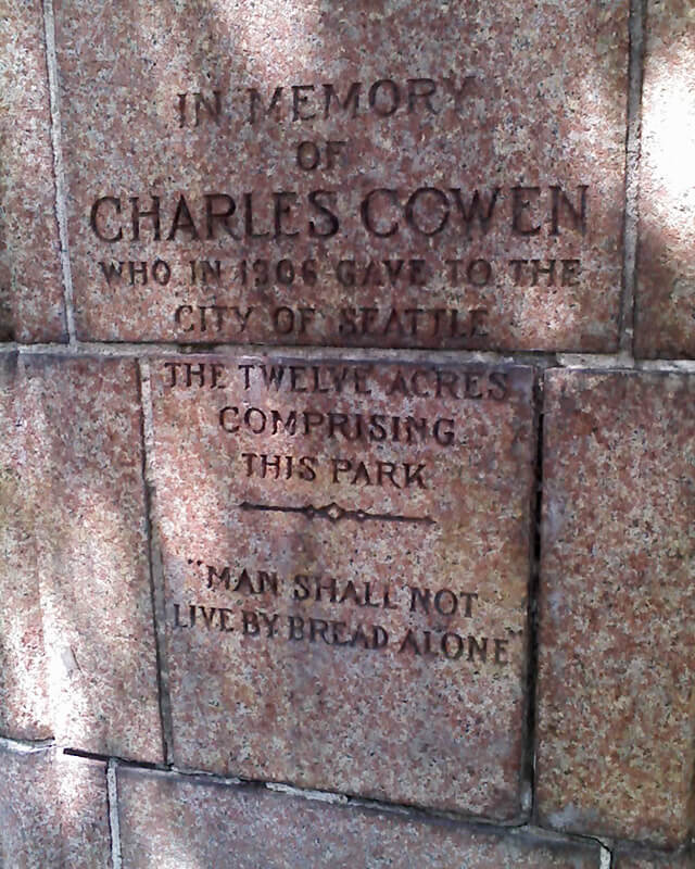
This street was created as part of the 1906 plat of Cowen’s University Park, filed by the Sylvester-Cowen Investment Company, of which Charles Cowen (1869–1926) was president. Originally Ravenna Place, it received its current name in 1918, according to an article in the January 29 issue of The Seattle Times. (This article also reported that the names of the individual streets that made up Queen Anne Boulevard would be restored and that Oriental Avenue [counterpart of the still-existing Occidental Avenue S] would become Third Avenue S). Whether it honors Cowen or the park named after him, which he donated to the city in 1906, is unclear.
Article in September 22, 1917, issue of The Seattle Times on Charles Cowen and his bounty on German leaders during World War I
Cowen was born in England, moved with his family to South Africa, and came to the United States in 1890, arriving in Seattle in 1900. Dotty DeCoster writes for HistoryLink.org:
Cowen was, by many accounts, a lively and active participant in developing the University District. According to architectural historian Shirley L. Courtois, he was British and had grown up in South Africa, where his family members were diamond miners and merchants. In 1890 he was sent to New York to purchase equipment for the mines. He never returned to South Africa. He apparently broke with his family, changed his name from Cohen to Cowen, and settled first in New York State, then in Florida, and finally in Seattle. Cowen reportedly retained a distinctively English style throughout his life.
The facts that his surname was originally Cohen and that his family was involved in diamond mining in South Africa led me to think he must have been Jewish, but I could find no definitive mention of his ethnicity online. However, in the March 19, 1926, issue of The Seattle Times, I found an article on the probate of his will, which mentioned that $2,000 of his $50,000 estate would go to the Hebrew Benevolent Society (today known as Jewish Family Service). That makes Cowen and Henry Fuhrman (1844–1907) (Fuhrman Avenue E) the only Jews I am aware of who have Seattle streets named after them.
Cowen Place NE begins at NE Ravenna Boulevard and University Way NE and goes just over 325 feet northeast to 15th Avenue NE, at the south end of the Cowen Park Bridge.
Born and raised in Seattle, Benjamin Donguk Lukoff had his interest in local history kindled at the age of six, when his father bought him settler granddaughter Sophie Frye Bass’s Pig-Tail Days in Old Seattle at the gift shop of the Museum of History and Industry. He studied English, Russian, and linguistics at the University of Washington, and went on to earn his master’s in English linguistics from University College London. His book of rephotography, Seattle Then and Now, was published in 2010. An updated version came out in 2015.
Born and raised in Seattle, Benjamin Donguk Lukoff had his interest in local history kindled at the age of six, when his father bought him settler granddaughter Sophie Frye Bass’s Pig-Tail Days in Old Seattle at the gift shop of the Museum of History and Industry. He studied English, Russian, and linguistics at the University of Washington, and went on to earn his master’s in English linguistics from University College London. His book of rephotography, Seattle Then and Now, was published in 2010. An updated version came out in 2015.
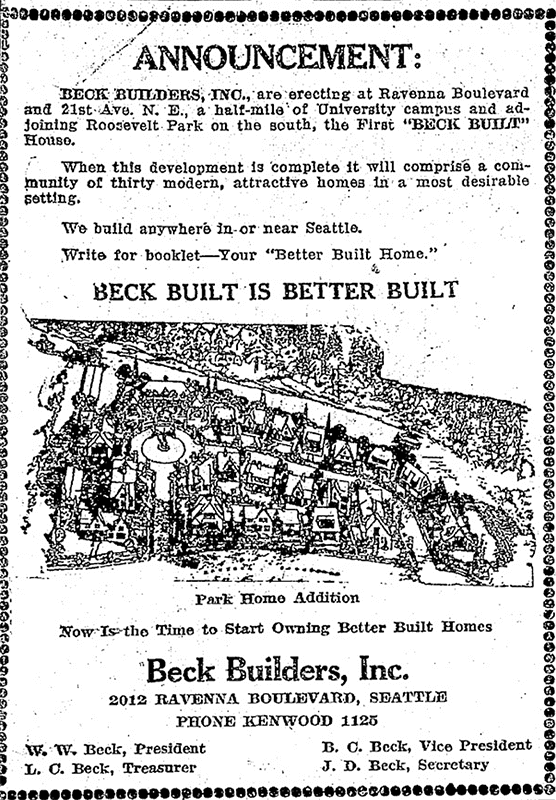
This street and its twin, Park Road NE, date to 1923, when William Wirt Beck developed the Park Home Addition between NE Ravenna Boulevard and Ravenna Park. They are best known for being the location of Candy Cane Lane, which has been a local Christmas attraction since the late 1940s. (The Park Road house of one Eugene Shostrom frequently appeared on The Seattle Times’ Christmas Tree Trail list before then, but it wasn’t until 1948 that the neighborhood as a whole participated — and won the award for best community display. [I wonder where that loving cup is today…])
NE Park Road begins at NE Ravenna Boulevard just west of Ravenna Avenue NE and goes around 350 feet first north, then west, to Park Road NE at Park Home Circle.
Park Home Addition Ad, The Seattle Times, April 30, 1923
Born and raised in Seattle, Benjamin Donguk Lukoff had his interest in local history kindled at the age of six, when his father bought him settler granddaughter Sophie Frye Bass’s Pig-Tail Days in Old Seattle at the gift shop of the Museum of History and Industry. He studied English, Russian, and linguistics at the University of Washington, and went on to earn his master’s in English linguistics from University College London. His book of rephotography, Seattle Then and Now, was published in 2010. An updated version came out in 2015.
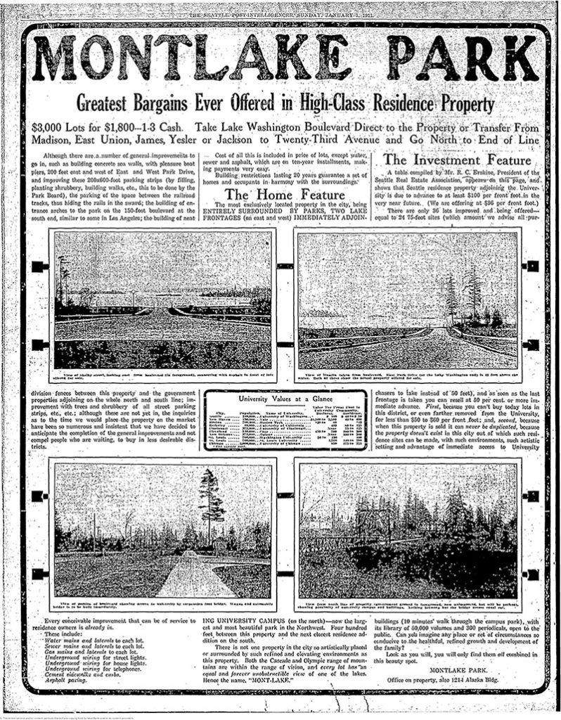
Montlake Park ad, Seattle P-I, January 1, 1911. “Both the Cascade and Olympic range of mountains are within the range of vision, and every lot has an equal and forever unobstructible view of one of the lakes [Lake Union and Lake Washington]. Hence the name, ‘MONT-LAKE.’”
Today, Montlake Boulevard E (as well as Washington State Route 513) begins at the intersection of E Lake Washington Boulevard and E Montlake Place E, just south of the Washington State Route 520 freeway, and goes 1⅓ miles north, then northeast, to NE 45th Street, just south of University Village. It becomes Montlake Boulevard NE as it crosses the Montlake Cut of the Lake Washington Ship Canal. (State Route 513 continues for another 2 miles along NE 45th Street and Sand Point Way NE, ending at NE 65th Street just west of Magnuson Park.)
Born and raised in Seattle, Benjamin Donguk Lukoff had his interest in local history kindled at the age of six, when his father bought him settler granddaughter Sophie Frye Bass’s Pig-Tail Days in Old Seattle at the gift shop of the Museum of History and Industry. He studied English, Russian, and linguistics at the University of Washington, and went on to earn his master’s in English linguistics from University College London. His book of rephotography, Seattle Then and Now, was published in 2010. An updated version came out in 2015.
In 1906, Harrison Avenue became Pacific Place and Railroad Avenue became Brintnall Place. (Why the opportunity wasn’t taken to match the names is unclear. Brintnall Place may have been named for Burgess W. Brintnall, who, according to the September 1912 issue of the Northwest Journal of Education, had been school superintendent for Olympia and Thurston County, founded the journal itself, and, after moving to Seattle in 1899, founded the Pacific Teachers Agency. He was murdered on July 3, 1912.)
At some point both streets became Pacific Street. Brintnall Place appears for the last time in The Seattle Times in October 1920, and Pacific Street for the first time in July 1921. The 1920 Kroll atlas shows all three names, including Pacific Place, indicating the change must have been planned at the time of its publication.
I haven’t seen any indication of why the Pacific name was chosen. Seattle got an Atlantic Street in 1895 — maybe it was thought the other major ocean deserved a street as well. But I wonder if it wasn’t named for the Northern Pacific, whose tracks the street ran along?
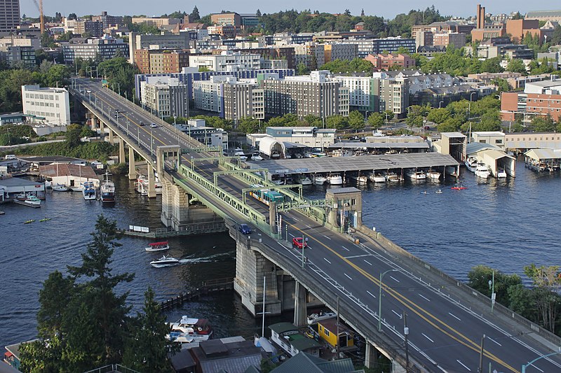
Today, NE Pacific Street begins at Montlake Boulevard NE, at the north end of the Montlake Bridge and the southeastern corner of the University of Washington campus, and goes ¾ of a mile to Eastlake Place NE, underneath the University Bridge, where it becomes NE Northlake Way. It begins again at NE 40th Street just west of the Ship Canal Bridge and goes another ¾ of a mile to N 34th Street just east of Meridian Avenue N.
Pacific Street’s current configuration is the result of a realignment that took place in the 1970s; originally, instead of turning west at University Way NE, it kept going northwest, cutting through what is now the University of Washington’s West Campus, and there was no interruption between the University and Ship Canal Bridges. The Burke–Gilman Trail follows the original railroad alignment, though, as does, for a few blocks, the campus road Cowlitz Road NE.
Born and raised in Seattle, Benjamin Donguk Lukoff had his interest in local history kindled at the age of six, when his father bought him settler granddaughter Sophie Frye Bass’s Pig-Tail Days in Old Seattle at the gift shop of the Museum of History and Industry. He studied English, Russian, and linguistics at the University of Washington, and went on to earn his master’s in English linguistics from University College London. His book of rephotography, Seattle Then and Now, was published in 2010. An updated version came out in 2015.
[Moore] chose the name because his addition “looked across the water” to Seattle proper like the New York borough of the same name that looks across the East River to Manhattan.
I haven’t been able to find an online source for this assertion, but Dorpat may have been referring to a passage in Roy G. Nielsen’s UniverCity: The Story of the University District in Seattle (1986), which quotes an article in the August 31, 1928, issue of the University Herald in which George F. Cotterill (mayor from 1912–1914) says:
[In 1885], there was no thought of a university and section sixteen was still untouched. J.A. Moore, one of the greatest Seattle real estate promoters of the time, started Brooklyn between 10th Ave. N.E. and the campus. This addition was intended by Mr. Moore to be to Seattle what Brooklyn is to New York.
Today’s Brooklyn Avenue is a block west of Moore’s. Again quoting Paul Dorpat:
None of James Moore’s street names survive. His Tremont Avenue became 15th Avenue. One block west he named University Way — the District’s future “Main Street” — Columbus Avenue. He called the future Brooklyn Avenue, “Broadway,” and this was Moore’s intended “Main Street.” He called 12th Avenue “Brooklyn.”
Brooklyn Avenue NE begins at NE Boat Street just north of Fritz Hedges Waterway Park and goes 1¾ miles north through the University District and Roosevelt neighborhood to NE 66th Street at Roosevelt High School. It resumes at NE 70th Street and goes just short of 300 feet to Froula Playground and the Roosevelt Reservoir. There is another segment between NE 75th Street and NE 77th Street and a final one between NE 80th Street and NE 82nd Street by Maple Leaf Reservoir Park.
Born and raised in Seattle, Benjamin Donguk Lukoff had his interest in local history kindled at the age of six, when his father bought him settler granddaughter Sophie Frye Bass’s Pig-Tail Days in Old Seattle at the gift shop of the Museum of History and Industry. He studied English, Russian, and linguistics at the University of Washington, and went on to earn his master’s in English linguistics from University College London. His book of rephotography, Seattle Then and Now, was published in 2010. An updated version came out in 2015.
This alley, which runs from NE 45th Street to NE 47th Street between 7th Avenue NE and 8th Avenue NE, adjacent to the Blue Moon Tavern, was named in 1995 for poet Theodore Huebner Roethke (1908–1963). A professor of English at the University of Washington from 1947 to 1963, Roethke won the Pulitzer Prize for Poetry in 1954, the National Book Award for Poetry in 1959 and (posthumously) 1965, and the Bollingen Prize for Poetry in 1959. His best-known poem may be “The Waking,” which begins:
I wake to sleep, and take my waking slow. I feel my fate in what I cannot fear. I learn by going where I have to go.
The Seattle Times says the resolution naming the alley “notes [Roethke] conducted numerous ‘symposia formal and informal in the Blue Moon Tavern and celebrated his receipt of both the Pulitzer and Bollingen prizes at the Blue Moon.’” The full text of the resolution is not available online, but I wonder if it specifically calls out the reason for Roethke Mews as opposed to Roethke Alley; as Knute Berger notes for Crosscut, it’s “a great pun on ‘muse’ if nothing else.”
Born and raised in Seattle, Benjamin Donguk Lukoff had his interest in local history kindled at the age of six, when his father bought him settler granddaughter Sophie Frye Bass’s Pig-Tail Days in Old Seattle at the gift shop of the Museum of History and Industry. He studied English, Russian, and linguistics at the University of Washington, and went on to earn his master’s in English linguistics from University College London. His book of rephotography, Seattle Then and Now, was published in 2010. An updated version came out in 2015.
Like NE Northlake Way, Eastlake Avenue E is so named because it runs along the shore of Lake Union — in this case, obviously, the eastern one. It, too, was earlier named Lake Avenue (in part), but this was changed as part of the Great Renaming of 1895. Ordinance 4044, Section 6 reads
That the names of Albert Street, Waterton Street, Lake Avenue and Green Street from Depot Street [changed by the same ordinance to Denny Way] to the shore of Lake Union at the northerly point of the Denny–Fuhrman addition, be and the same are hereby changed to Eastlake Avenue.
Today, Eastlake, at 2⁹⁄₁₀ miles in length, extends slightly farther north and south than the roadway mentioned in the ordinance. It starts in the south at the intersection of Court Place and Howell Street as Eastlake Avenue, then becomes Eastlake Avenue E a block north as it crosses Denny Way. From here to just south of E Galer Street it divides the Avenue: E; Street: E section of town from the Avenue: N; Street section. Just north of Portage Bay Place E it crosses Lake Union as the University Bridge, then continues on as the one-way–northbound Eastlake Avenue NE to 11th Avenue NE just north of NE 41st Street. (Southbound, it is fed by Roosevelt Way NE at NE Campus Parkway.)
Eastlake, like Fairview and Boren Avenues, is one of the few north–south streets in Seattle to have three different directional designations.
Born and raised in Seattle, Benjamin Donguk Lukoff had his interest in local history kindled at the age of six, when his father bought him settler granddaughter Sophie Frye Bass’s Pig-Tail Days in Old Seattle at the gift shop of the Museum of History and Industry. He studied English, Russian, and linguistics at the University of Washington, and went on to earn his master’s in English linguistics from University College London. His book of rephotography, Seattle Then and Now, was published in 2010. An updated version came out in 2015.
As explained in NE Boat Street, NE Northlake Way was originally Lake Avenue in the 1890 Brooklyn Addition to Seattle, so named because it ran along the northern shore of Lake Union. I couldn’t find an ordinance changing its name from Lake Avenue (used elsewhere, notably for what are now Westlake Avenue and Fremont Avenue N and for part of Eastlake Avenue E) to Northlake Avenue, but the latter name begins to appear in local newspapers in 1901. (Complicating matters slightly, the street appears as North Lake Avenue in the state’s 1907 plat of Lake Union Shore Lands.) Northlake Avenue began being referred to as Northlake Way in 1935, and this was made official in 1956.
Today, NE Northlake Way begins at the west end of NE Pacific Street under the University Bridge at Eastlake Place NE, and continues 1½ miles west to just shy of the Aurora Bridge, where it becomes a private road through formerly industrial land developed by the Fremont Dock Company into a business park. (The Puget Sound Business Journal and The Seattle Times have good articles on how over the years Suzie Burke transformed her father’s Burke Millwork Co., which opened in 1939, into what is today home to local offices for Google and Adobe and corporate headquarters for Tableau and Brooks Sports, among other tenants.) This private roadway continues for ⅖ of a mile beyond the end of the public right-of-way to the intersection of N Canal Street, N 34th Street, and Phinney Avenue N.
NE Northlake Way once began ⅖ of a mile further east, at NE Columbia Road on the University of Washington South Campus, but this stretch was changed to NE Boat Street in 1962, not without some controversy.
Born and raised in Seattle, Benjamin Donguk Lukoff had his interest in local history kindled at the age of six, when his father bought him settler granddaughter Sophie Frye Bass’s Pig-Tail Days in Old Seattle at the gift shop of the Museum of History and Industry. He studied English, Russian, and linguistics at the University of Washington, and went on to earn his master’s in English linguistics from University College London. His book of rephotography, Seattle Then and Now, was published in 2010. An updated version came out in 2015.
The Director of Highways is hereby authorized and directed to select and locate a suitable and fitting street and highway approach to the University of Washington campus in the City of Seattle, from Roosevelt Way to Fifteenth Avenue northeast, including an underpass beneath the surface of Roosevelt Way, and necessary approaches to said underpass.
(A separate section appears to have been responsible for the creation of Stadium Way in Pullman as an approach to Washington State University.) A Seattle ordinance passed the same year committed the city to build and maintain the road, as required by the law, and NE Campus Parkway opened in 1950 — HistoryLink refers to it as a “long-proposed ceremonial gateway to the University.” In 1954, the roadway was deeded to the city.
Portion of the Regents Plan showing planned route of Campus Parkway
In 1925 Bebb and Gould proposed a revision to their earlier Regents Plan of 1915, which included a formal boulevard that extended from the University to the west to serve as a principal entry to the campus from the city. Campus Parkway, the formal axis envisioned in the Regents Plan to the west, was constructed finally in the 1940s. It extended the University campus into its surrounding city neighborhood in a monumental and somewhat strident manner. Construction in the 1970s of an underground parking garage, below the Central Quadrangle [actually the Central Plaza, or Red Square], provided a primary vehicle entry south of Denny Hall, and reduced vehicular traffic along the campus ring road.
Traffic to and from lower campus and the lower University District via the University Bridge does necessarily take NE Campus Parkway, but it hardly functions as a gateway, ceremonial or otherwise. The entrance to the above-mentioned parking garage is at NE 41st Street, a block to the north; the west entrance to campus is a block to the south at NE 40th Street, which turns into W Stevens Way NE. One must take a narrow pedestrian bridge over 15th Avenue NE to walk from the parkway onto campus. The pedestrian-only southeast entrance at Rainier Vista and the north entrance at 17th Avenue NE, which turns into Memorial Way NE, fulfill the function far better.
Not even the UW Visitor Center is on NE Campus Parkway, having moved to Odegaard Library a number of years ago. Schmitz Hall, one of the university’s main administrative buildings, remains, between University Way NE and 15th Avenue NE, and with it the Office of Undergraduate Admissions and the Office of the University Registrar — and the university’s “generic address for forms,” 1410 NE Campus Parkway.
(An aside — NE Campus Parkway was once home to the International Friendship Grove of Trees [see articles by Arthur Lee Jacobson and Dick Falkenbury] but many of the trees have since died or been removed.)
Born and raised in Seattle, Benjamin Donguk Lukoff had his interest in local history kindled at the age of six, when his father bought him settler granddaughter Sophie Frye Bass’s Pig-Tail Days in Old Seattle at the gift shop of the Museum of History and Industry. He studied English, Russian, and linguistics at the University of Washington, and went on to earn his master’s in English linguistics from University College London. His book of rephotography, Seattle Then and Now, was published in 2010. An updated version came out in 2015.
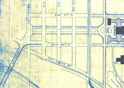
This street, which runs ⅕ of a mile from the “five corners” intersection with NE 45th Street, NE 45th Place, and Union Bay Place NE in the northwest to NE 41st Street in the southeast, was created in 1911 as an extension of Union Bay Place. It was renamed in 1995 in honor of Mary Maxwell Gates (1929–1994), mother of Microsoft co-founder Bill Gates and a member of the University of Washington Board of Regents from 1975 to 1993.
The original proposal was to also change the name of NE 41st Street between Union Bay Place NE and Surber Drive NE to NE Mary Gates Memorial Drive, but this was not done. An article in the March 14, 1995, issue of The Seattle Times reports that “City Councilwoman Sue Donaldson said the Laurelhurst Community Club, the university and its neighbors near Union Bay Place Northeast joined yesterday in asking” for the name change, and an article in the September 1995 issue of Columns, then the name of the University of Washington alumni magazine, reports Donaldson as saying “The new name is particularly fitting… because it was the route Gates took from home to campus.”
I have never seen an explanation as to why the proposed name wasn’t simply Mary Gates Drive NE — it is the only “memorial” thoroughfare in town.
Born and raised in Seattle, Benjamin Donguk Lukoff had his interest in local history kindled at the age of six, when his father bought him settler granddaughter Sophie Frye Bass’s Pig-Tail Days in Old Seattle at the gift shop of the Museum of History and Industry. He studied English, Russian, and linguistics at the University of Washington, and went on to earn his master’s in English linguistics from University College London. His book of rephotography, Seattle Then and Now, was published in 2010. An updated version came out in 2015.
This street runs just shy of 2,000 feet from NE Pacific Street in the west, just east of the University Bridge, to NE Columbia Road in the east, on the University of Washington South Campus.
Originally Lake Avenue in the 1890 Brooklyn Addition to Seattle, as it ran along the north shore of Lake Union, it became Northlake Avenue at some point between then and 1901, based on my search of Seattle Times, Seattle Star, and Seattle Post-Intelligencer archives. It starts being referred to as Northlake Way in 1935, though it seems this wasn’t formalized until 1956.
Portion of Map of Brooklyn Addition to Seattle, 1890, showing Lake Avenue (now NE Boat Street) and Railroad Avenue (now NE Pacific Street)
In 1960, Jerry Bryant of Bryant’s Marina proposed that all of Northlake Way — beginning far to the west, at the Fremont Bridge — receive the new name of Boat Street, but the 1962 ordinance establishing Boat Street only changes the name of the few blocks between the University Bridge and the UW campus. The Seattle P-I reports on December 22, 1960, that the Street Naming Committee of the Board of Public works rejected the proposal “because the present name is more descriptive,” but Bryant went ahead and filed his proposal with the City Council anyway in 1961.
According to The Seattle Times on May 24, 1962, the Board of Public Works once again asked the City Council to reject the proposal, which was “backed by more than 50 marine firms or individuals… [and] the University Commercial Club,” but on June 20, the Times reported that the City Council Streets and Sewers Committee approved the change. This met with much opposition. On July 2, the Times published a letter from Vince Lieb, 668 NE Northlake Way, that read, in part, that “numerous business firms… are more than a little chagrined at the City Council’s recent move… to please a minority of merchants who hawk their wares along the way,” and wondered if this might set a precedent:
We can think of such dandies as “Chop Suey Street,” “Gas and Oil Street,” “Beer Street,” and “Fish Street.” How about “Sand and Gravel Street” for a paved thoroughfare?
That same day, according to the P-I, the City Council postponed the implementation of the name change, sending it back to committee, and on July 10, according to the Times, the committee said it would give proponents and opponents two weeks to gather signatures, as the original petition had somehow been lost. Finally, on the 24th, they came up with a compromise: The name would be changed between the University Bridge and 15th Avenue NE only. This is where Bryant’s Marina was located, as well as the Jensen Motor Boat Company, which lasted until 2019 and was the last shipyard left on NE Boat Street.
From The Seattle Times, July 25, 1962
Today, Fritz Hedges Waterway Park — built on the former site of the marina — occupies most of the Boat Street waterfront.
Born and raised in Seattle, Benjamin Donguk Lukoff had his interest in local history kindled at the age of six, when his father bought him settler granddaughter Sophie Frye Bass’s Pig-Tail Days in Old Seattle at the gift shop of the Museum of History and Industry. He studied English, Russian, and linguistics at the University of Washington, and went on to earn his master’s in English linguistics from University College London. His book of rephotography, Seattle Then and Now, was published in 2010. An updated version came out in 2015.
This street runs nearly 6 miles from the north end of the University Bridge in the south (at Eastlake Avenue NE and NE Campus Parkway) to Aurora Avenue N in the north, just shy of Seattle city limits at N 145th Street. It runs north–south for most of its length, but starting at NE 125th Street, its last 1½ miles cut a northwest–southeast diagonal across the street grid, making it Roosevelt Way N once it crosses 1st Avenue NE between N 133rd and N 135th Streets.
Originally 10th Avenue NE south of NE 125th Street, Roosevelt received its current name in 1933. According to local historian Feliks Banel, this was first proposed in 1927 by businesses in the Roosevelt district, itself having taken that name earlier in the decade in honor of President Theodore Roosevelt, who died in 1919. Nothing came of it for six years, but in 1933 they tried again and asked that 10th Avenue be renamed after both Theodore and Franklin Delano Roosevelt, who had been elected president the previous November. As Banel notes in his piece, The Seattle Times had this to say:
This change, we assume, must be pleasing to local Democrats of all sorts and shades. At the same time, due to the incidence of somewhat tenuous family ties, it cannot be at all displeasing to Republicans. The name of Roosevelt has high standing in both political parties, as indeed it has throughout the world. Even now it is quite certain that those who may traverse our Roosevelt Way in years to come will neither know nor particularly care whether it was named for Teddy or for Frank.
As for its diagonal stretch, it appears on old King County maps as M. Roy Sayles Road (County Road 2240), Golf Way, and State Highway 1J (predecessor of today’s SR 513). It ceased to be a state highway in 1991. As for when it, too, became Roosevelt Way, it’s difficult to tell as King County doesn’t have as good a system for looking up ordinances online as Seattle’s. It appears as Roosevelt Way on a 1966 map in local historian Rob Ketcherside’s maps album on Flickr, but as Golf Way in another one from 1947. As the area in question wasn’t annexed into Seattle until 1953, the name must have been changed by the county sometime between 1947 and 1953 in anticipation. (The 1933 Seattle ordinance is the only one on file relating to Roosevelt Way’s name, so this must have been a county change.)
As for M. Roy Sayles, The International Confectioner’s January 1915 issue reports that he, along with Annie B. Sayles, C.M. Sayles, and W.H. Rogers, founded the Rogers Candy Co. in Seattle in 1915; and Golf Way almost certainly comes from the road’s proximity to the public course at Jackson Park, which opened in 1928.
Born and raised in Seattle, Benjamin Donguk Lukoff had his interest in local history kindled at the age of six, when his father bought him settler granddaughter Sophie Frye Bass’s Pig-Tail Days in Old Seattle at the gift shop of the Museum of History and Industry. He studied English, Russian, and linguistics at the University of Washington, and went on to earn his master’s in English linguistics from University College London. His book of rephotography, Seattle Then and Now, was published in 2010. An updated version came out in 2015.
This street runs 1¼ mile from NE Pacific Street in the south to NE Ravenna Boulevard and Cowen Park in the north. Until 2001, it was a block longer, starting farther south at NE Boat Street, but that portion was vacated as part of the development of the University of Washington campus.
Originally Columbus Avenue and then 14th Avenue NE, it was renamed University Way in 1920 after the University of Washington, which had moved to the neighborhood from its original home downtown in 1895. As local historian Paul Dorpat explains in this HistoryLink essay,
[In 1919] the University Commercial Club… ran [a contest] to rename 14th Avenue…. Club member Arthur Quigley’s “University Way” won the street name contest easily. To deflect any charges that the contest was fixed, Quigley donated the prize money to charity.
Even though it’s been a “way” for 101 years now, to locals University Way has always been, and always will be, “The Ave.” And that in itself will always cause some confusion, as this street sign demonstrates.
Born and raised in Seattle, Benjamin Donguk Lukoff had his interest in local history kindled at the age of six, when his father bought him settler granddaughter Sophie Frye Bass’s Pig-Tail Days in Old Seattle at the gift shop of the Museum of History and Industry. He studied English, Russian, and linguistics at the University of Washington, and went on to earn his master’s in English linguistics from University College London. His book of rephotography, Seattle Then and Now, was published in 2010. An updated version came out in 2015.
I end my piece on Lushootseed-language place names in Seattle, “Native names abide,” thus:
…Let Carkeek remain Carkeek, but know that it was once and is still kʷaatəb, as Montlake is still stəx̌ʷugʷił, the Locks, which lowered x̌ačuʔ and x̌áx̌əʔčuʔ, still xʷiwálqʷ, and University Village still sluʔwił village, and celebrate that wǝɫǝbʔaltxʷ now sits where Whitman and Stevens meet.
wǝɫǝbʔaltxʷ – Intellectual House is “a longhouse-style facility on the [University of Washington] Seattle campus [that] provides a multi-service learning and gathering space for American Indian and Alaska Native students, faculty and staff, as well as others from various cultures and communities to come together in a welcoming environment to share knowledge.” Its location at the corner of Stevens Way and Whitman Court is significant in that almost all campus roads are named for Washington counties, and these two counties were named after Isaac Stevens and Marcus and Narcissa Whitman:
The Whitmans’ story is more complex. The missionary couple were among 13 whites killed by a group of Cayuse Indians in what has become known as the Whitman massacre. A measles epidemic in the mission settlement and a nearby Cayuse village produced a death rate far higher among the Cayuse; Marcus Whitman, who was a also a physician and tried to treat the Cayuse as well as the whites, was accused of poisoning tribe members: “the fact that nearly all of his white patients recovered while his Indian patients died convinced some Cayuses that he was deliberately poisoning Indians in order to give their land to white setters.” Even though this is unlikely, the fact remains that they were missionaries and colonizers, and there have been calls to replace the statue of Marcus that stands in the National Statuary hall.
The UW Board of Regents made this change in May 2018, but the sign only recently made its appearance. I asked the writer of the University of Washington Magazine piece on the name change, Hannelore Sudermann, if she knew whether “the renaming was official — that Whitman Court no longer exists and the street’s name is now sluʔwiɫ – or if it was honorary and the street is still officially Whitman Court,” and she pointed me to the meeting minutes, which read, in part:
The Board of Regents chooses to honor the Coast Salish peoples of the land on which the University of Washington sits, and indigenous peoples across the State, by renaming Whitman Court sluʔwił.… In the Lushootseed language of the Coast Salish peoples, sluʔwił is the name for the village site closest to the campus, and means ‘Little Canoe Channel.’… It is the Board’s intention to recognize the native place-names of the region and thereby to enrich the historical context of the campus. The Board feels that this naming action is particularly appropriate, given the proximity of Whitman Court to wǝɫǝbʔaltxʷ, meaning ‘Intellectual House,’ a multi-service learning and gathering space for American Indian and Alaska Native students, faculty, and staff.
Even though an earlier part of the minutes reads “Regent Rice moved, Regent Ayer seconded, and the Board of Regents approved the honorific renaming of Whitman Court sluʔwił” (italics mine), given the excerpt above and the presence of the sign without any reference to Whitman Court, my interpretation is that honorific here means “in honor of,” in contrast to honorary meaning “symbolic.”
Update as of February 16, 2023: I recently noticed that sluʔwiɫ is appearing on maps (UW, OpenStreetMap) as sluʔwiɫ (Little Canoe Channel NE). Per the UW’s page on McMahon Hall, “Whitman Court NE has been renamed Sluʔwił (Little Canoe Channel NE). Although street signs have changed, you may hear the street referred to by both names as the name change awaits formal state recognition. The name change acknowledges the Duwamish Peoples who continue to fight for federal recognition as a tribe, and who lived and engaged in potlaches, gift-giving festivals of sharing and trading, in the area, until the land was colonized by white settlers.”I will try to find out when and how formal state recognition will come.
Born and raised in Seattle, Benjamin Donguk Lukoff had his interest in local history kindled at the age of six, when his father bought him settler granddaughter Sophie Frye Bass’s Pig-Tail Days in Old Seattle at the gift shop of the Museum of History and Industry. He studied English, Russian, and linguistics at the University of Washington, and went on to earn his master’s in English linguistics from University College London. His book of rephotography, Seattle Then and Now, was published in 2010. An updated version came out in 2015.


