SW Massachusetts Street begins in West Seattle at the intersection of Bonair Drive SW, 47th Avenue SW, and Sunset Avenue SW, and goes just under ⅓ of a mile east to Palm Avenue SW. It begins again at Ferry Avenue SW and goes just over 450 feet east to Victoria Avenue SW. There is a short segment (just over 400 feet) on Harbor Island east of 13th Avenue SW, and then another one, about the same length, leading from Alaskan Way S to the entrance to U.S. Coast Guard Base Seattle. (Here, the street’s directional designation has changed to S, it being east of the Duwamish Waterway.)
S Massachusetts Street resumes at Colorado Avenue S and goes ⅙ of a mile east to Occidental Avenue S. There is a block-long segment east of 4th Avenue S to just shy of the SODO Busway, and then a longer one — about ¼ of a mile — from the SODO Trail to Airport Avenue S.
East of Interstate 5, on Beacon Hill, S Massachusetts Street begins at 11th Avenue S and goes nearly ¼ of a mile east to just past 15th Avenue S, the portion between 14th Avenue S and 15th Avenue S being pedestrian-only, as the right-of-way between the sidewalks has been turned into the Beacon Bluff P-Patch community garden. It begins again just west of Sturgus Avenue S and goes nearly a mile east to just past 31st Avenue S, the portion that runs for half a block west of 17th Avenue S being a pathway. S Massachusetts Street resumes for the last time at 32nd Avenue S and goes ¼ mile east to Lake Washington, where it is a shoreline street end.
Born and raised in Seattle, Benjamin Donguk Lukoff had his interest in local history kindled at the age of six, when his father bought him settler granddaughter Sophie Frye Bass’s Pig-Tail Days in Old Seattle at the gift shop of the Museum of History and Industry. He studied English, Russian, and linguistics at the University of Washington, and went on to earn his master’s in English linguistics from University College London. His book of rephotography, Seattle Then and Now, was published in 2010. An updated version came out in 2015.
This street is named for David Thomas Denny (1832–1903). He was one of the members of the Denny Party that landed at Alki Point in 1851, led by his older brother, Arthur Armstrong Denny (1822–1899). In 1853, he married his sister-in-law, Louisa Boren (1827–1916). (Louisa’s older sister, Mary Ann Boren [1822–1910], had married Arthur in 1843. She, Louisa, and their brother, Carson Dobbins Boren [1824–1912], were also part of the Denny Party).
The Dennys settled on land in what is now Lower Queen Anne, living in a series of houses in the area until they went bankrupt in the Panic of 1893 and had to leave their mansion for their summer cottage at Licton Springs, where they lived with their oldest child, Emily Inez Denny (1853–1918), until they died.
Denny Park is named for the couple, which had given the land to the city as its first cemetery in 1861; the bodies were moved to the Washelli Cemetery on Capitol Hill in the 1880s, at which time the original cemetery was converted to a park, likewise the city’s first. (Just a few years later, Washelli was also converted to a park, initially known as Lake View Park, then City Park, and finally, in 1901, Volunteer Park. The Dennys’ private burial ground near the no-longer-existent Oak Lake eventually became the Oaklake Cemetery, which, after being sold by their son Victor in 1914, was renamed Washelli after the original cemetery of that name; Evergreen Cemetery, across Aurora Avenue N from Washelli, bought the latter in 1922, and the combined cemetery took its current name, Evergreen Washelli, in 1962.)
David Denny was active in government. According to HistoryLink.org, he was:
…Probate judge, King County commissioner, Seattle City Council member, a director of the Seattle School District, and regent of the Territorial University of Washington.… Denny was an ardent advocate of woman suffrage and helped lead the movement that in the 1880s won Washington women the right to vote. He opposed the expulsion of Chinese immigrants in 1886, which antagonized local nativists.
Denny was also involved in the development of a number of Seattle neighborhoods; in addition to Queen Anne, he developed tracts in South Lake Union, Capitol Hill, and Ravenna, and founded the Rainier Power and Railway Company, which ran the first streetcar from Downtown (Pioneer Square) to the University District (Ravenna Park).
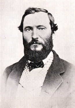
David T. Denny, 1890. Courtesy of the Seattle Municipal Archives, Identifier 175313.
Denny Way — originally named Depot Street by Denny after a proposed train station that never materialized — begins as a shoreline street end on Elliott Bay, indistinguishable from the surrounding Myrtle Edwards Park. On the other side of the BNSF Railway tracks, W Denny Way begins as a pathway and stairway from Elliott Avenue to Western Avenue. From here, it is a major arterial, becoming Denny Way as it crosses Queen Anne Avenue N (originally named Temperance Street by Denny), and going 2½ miles east to E Madison Street and 22nd Avenue. (It becomes a neighborhood street on crossing E Olive Way, and the block between Broadway and 10th Avenue E was renamed E Barbara Bailey Way in 2019). E Denny Way begins again at E Madison Street and 23rd Avenue and goes ⅘ of a mile east to Madrona Place E and 38th Avenue, where it turns into Madrona Drive.
Denny Way, which becomes E Denny Way east of Eastlake Avenue E, also divides five of the city’s directional designation zones from each other, similarly to Yesler Way. North of Denny but west of Queen Anne Avenue N, east–west streets carry the W prefix and north–south avenues carry the suffix W. North of Denny between Queen Anne Avenue N and Eastlake Avenue E, east–west streets carry no prefix and north–south avenues carry the suffix N. North of Denny east of Eastlake Avenue E, east–west streets carry the E prefix and north–south avenues carry the suffix E. South of Denny but west of a line that includes Melrose Avenue, Minor Avenue, E Union Street, and Broadway, neither east–west streets nor north–south avenues carry a prefix or suffix. And south of Denny but east of that line, east–west streets carry the E prefix and north–south avenues carry no suffix.
Born and raised in Seattle, Benjamin Donguk Lukoff had his interest in local history kindled at the age of six, when his father bought him settler granddaughter Sophie Frye Bass’s Pig-Tail Days in Old Seattle at the gift shop of the Museum of History and Industry. He studied English, Russian, and linguistics at the University of Washington, and went on to earn his master’s in English linguistics from University College London. His book of rephotography, Seattle Then and Now, was published in 2010. An updated version came out in 2015.
This street is named after Henry Leiter Yesler (1810–1892). Originally from Leitersburg, Maryland, which was founded by his great-grandfather, and living in Massillon, Ohio, before coming west, he moved to Seattle from Portland, Oregon, in 1852. As John Caldbick writes for HistoryLink.org:
…[Yesler] quickly established himself as the most important resident of the rain-swept little spot that would soon become Seattle. He had the first steam-powered sawmill on Puget Sound up and running within months, and for several years he employed almost every male settler in Seattle and a considerable number of Native Americans. His mill was early Seattle’s only industry, and without it the town’s development would have been greatly delayed.
Carson Dobbins Boren and David Swinson “Doc” Maynard had already claimed land on Elliott Bay either side of what is today Pioneer Square, but they gave him part of their claims so he could access the water from the claim he made farther up First Hill. Yesler’s mill was built at the foot of what is now Yesler Way but was originally Mill Street, also known as Skid Road — and yes, Seattle may be where the term originated, referring to a neighborhood largely inhabited by the “down and out.”
Yesler was also King County auditor in 1852, and Seattle mayor from 1874 to 1875 and 1885 to 1886.
Yesler had two children: a son, Henry George Yesler (1845–1859), by his wife, Sarah Burgert Yesler (1822–1887); and a daughter, Julia Benson Intermela (1855–1907). Her mother wasn’t Sarah, who didn’t come to Seattle until 1858, but rather a Duwamish woman named Susan, daughter of Salmon Bay Curley (Su-quardle), who had worked at Yesler’s mill. When Sarah finally joined her husband, he sent Susan and Julia to live with Jeremiah S. Benson, a cook at the mill. In the 1870 territorial census, Julia is listed as living with the Bensons, but the next year she is listed as a HB (“half-breed”) house servant for the Yeslers. Unlike Rebecca Lena Graham, who successfully sued the relatives of Franklin Matthias to be recognized as his rightful heir, Julia inherited nothing when her father died in 1892. Even so,
…The settlement of Henry Yesler’s estate was an imbroglio of epic proportions. It pitted Minnie Gagle Yesler [a younger cousin whom he married a few years before his death] and her mother against James Lowman [his nephew] and municipal authorities, who believed that Yesler had made a will that left most of his fortune, by then worth more than $1,000,000, to the city, hoping thereby to cement his reputation as the “Father of Seattle.”
Yesler is also quoted as anticipating “Strange Fruit” by 55 years… though it’s by no means a sentiment Abel Meeropol or Billie Holiday would have shared. In January 1882, a mob lynched James Sullivan, William Howard, and Benjamin Paynes between two of his maple trees. Harper’s Weekly reported Yesler’s reaction: “That was the first fruit them trees ever bore, but it was the finest.”
Henry L. Yesler. Courtesy of the Seattle Municipal Archives, Identifier 12257
Yesler Way begins on the Elliott Bay waterfront at Alaskan Way and goes 2⅙ miles east to Leschi Park, just past 32nd Avenue. It also appears just west of Lake Washington Boulevard, where it goes about 200 feet west and essentially serves as a driveway for a couple of houses.
Yesler Way, which becomes E Yesler Way east of Broadway, also divides three of the city’s directional designation zones from each other. South of Yesler, east–west streets carry the S prefix and north–south avenues carry the suffix S. North of Yesler, north–south avenues carry no suffix; east–west streets carry the E prefix east of Broadway and no prefix west of Broadway.
Born and raised in Seattle, Benjamin Donguk Lukoff had his interest in local history kindled at the age of six, when his father bought him settler granddaughter Sophie Frye Bass’s Pig-Tail Days in Old Seattle at the gift shop of the Museum of History and Industry. He studied English, Russian, and linguistics at the University of Washington, and went on to earn his master’s in English linguistics from University College London. His book of rephotography, Seattle Then and Now, was published in 2010. An updated version came out in 2015.
Howell was captain of the SS Pacific, en route from Victoria to San Francisco, when it sank off Cape Flattery the evening of November 4, 1875. Only one passenger and one crew member survived of nearly 275 aboard, making it the worst maritime disaster on the West Coast to date. As Daryl C. McClary writes for HistoryLink.org:
Although lost at sea, Jefferson Davis Howell was not forgotten by his many friends in Puget Sound. They had a 10-foot-tall sandstone obelisk erected in his memory at the Seattle Masonic Cemetery, established in 1872 and renamed the Lake View Cemetery in 1890. On the base of the monument is chiseled the simple epitaph: “Captain J. D. Howell, perished at sea on the steamship Pacific, November 4, 1875, aged 34 years.”
Howell Street begins at 8th Avenue and Olive Way and goes ⅓ of a mile northwest to Eastlake Avenue, just west of Interstate 5. On the other side of the freeway, it resumes at Bellevue Avenue as E Howell Street and goes ⅕ of a mile east to Harvard Avenue, where it is blocked by Seattle Central College. After a very short segment between Broadway and Nagle Place, it begins again east of Cal Anderson Park at 11th Avenue and goes ½ a mile east to 19th Avenue. E Howell Street resumes at Homer Harris Park at 24th Avenue and goes ¾ of a mile east to 38th Avenue, being a stairway and pathway between the alley east of 25th Avenue and 26th Avenue. It begins again at Madrona Drive and goes ⅒ of a mile east to 39th Avenue E and Evergreen Place. Its last segment is just over 100 feet long, from Lake Washington Boulevard to Howell Place and Howell Park beach.
Born and raised in Seattle, Benjamin Donguk Lukoff had his interest in local history kindled at the age of six, when his father bought him settler granddaughter Sophie Frye Bass’s Pig-Tail Days in Old Seattle at the gift shop of the Museum of History and Industry. He studied English, Russian, and linguistics at the University of Washington, and went on to earn his master’s in English linguistics from University College London. His book of rephotography, Seattle Then and Now, was published in 2010. An updated version came out in 2015.
“A street of good intentions but easily thwarted,” as Sophie Frye Bass puts it in Pig-Tail Days in Old Seattle, John Street is “named for two Johns,” she writes — “For John Denny [1793–1875], the father of Arthur and David, and John B. [1862–1913], the son of David.”
John Denny
John Bunyan Denny
Today, W John Street begins at Western Avenue W and goes ⅓ of a mile east to 2nd Avenue N and the Pacific Science Center campus. John Street resumes just east of the Space Needle at Broad Street and goes ½ a mile to Terry Avenue N. Picking up half a block to the east, it makes it a further ⅓ of a mile before being blocked by Interstate 5 at Stewart Street and Eastlake Avenue E. Resuming at Melrose Avenue E, it goes ⅙ of a mile to E Olive Way, which itself becomes E John Street a few blocks to the east at Broadway E. From there, it’s ⅓ of a mile to the Kaiser Permanente Capitol Hill Medical Center at 15th Avenue E. After beginning again at 16th Avenue E, E John makes it nearly a mile before being stopped by the Harrison Ridge Greenbelt at 32nd Avenue E. Its final stretch is ⅓ of a mile from the 33rd Avenue E right-of-way to 39th Avenue E at Viretta Park.
Born and raised in Seattle, Benjamin Donguk Lukoff had his interest in local history kindled at the age of six, when his father bought him settler granddaughter Sophie Frye Bass’s Pig-Tail Days in Old Seattle at the gift shop of the Museum of History and Industry. He studied English, Russian, and linguistics at the University of Washington, and went on to earn his master’s in English linguistics from University College London. His book of rephotography, Seattle Then and Now, was published in 2010. An updated version came out in 2015.
This street — named Pine Street in Terry’s Second Addition to the Town of Seattle, filed in 1872 — was renamed Terrace in 1876, presumably to avoid duplicating the Pine Street to the north. My assumption is it was given this name because of how steep First Hill is at this point — Paul Dorpat, writing for HistoryLink, says “Except at Terrace Street on the south and near Union Street on the north, the hill was readily negotiable first by hikers and later by street graders and trolley tracks.” One can see in the image below the long, steep stairway in the Terrace Street right-of-way “from 5th Avenue east to beyond 7th Avenue,” as Dorpat writes on his own blog.
Seattle Weights and Measures Division officials standing with confiscated scales in Terrace Street, 1917. Note long stairway in upper-right corner. Courtesy of the Seattle Municipal Archives, Identifier 1210.
Today, Terrace Street begins at Yesler Way above 4th Avenue and goes a block and a half up the hill before being blocked by Interstate 5. It resumes just east of Harborview Medical Center and goes ⅓ of a mile east to 12th Avenue. There is another short stretch of E Terrace Street from 20th Avenue to 23rd Avenue by Garfield High School, and then a final ½ mile from 30th Avenue to Lake Washington Boulevard in Leschi, the portion between 36th Avenue and Randolph Avenue being a stairway.
Born and raised in Seattle, Benjamin Donguk Lukoff had his interest in local history kindled at the age of six, when his father bought him settler granddaughter Sophie Frye Bass’s Pig-Tail Days in Old Seattle at the gift shop of the Museum of History and Industry. He studied English, Russian, and linguistics at the University of Washington, and went on to earn his master’s in English linguistics from University College London. His book of rephotography, Seattle Then and Now, was published in 2010. An updated version came out in 2015.
Because Squire was the first to apply the name to a street, I count E Remington Court as ultimately being named after his wife, Ida, though one could say Greene’s preservation of the name, after the E Jefferson Street name had been extended by ordinance in 1895 from First Hill to Lake Washington, might also have been to honor his mother, Catherine.
Watson Carvosso Squire and his wife, Ida Remington, circa 1910
Born and raised in Seattle, Benjamin Donguk Lukoff had his interest in local history kindled at the age of six, when his father bought him settler granddaughter Sophie Frye Bass’s Pig-Tail Days in Old Seattle at the gift shop of the Museum of History and Industry. He studied English, Russian, and linguistics at the University of Washington, and went on to earn his master’s in English linguistics from University College London. His book of rephotography, Seattle Then and Now, was published in 2010. An updated version came out in 2015.
Today, E Spruce Street begins at Broadway and goes nearly a mile east to 25th Avenue, only interrupted once, at Boren Avenue, which it connects to as a pair of stairways. It resumes at 28th Avenue and goes just over ¼ of a mile to Lake Dell Avenue (the portion from Peppi’s Playground through Peppi’s Woods as a stairway). Farther east, there is a couple-hundred-foot-long section at the west end of Euclid Avenue, and then a longer one — almost ⅒ of a mile — from near the east end of Euclid Avenue to E Alder Street. (Its complicated end is the result of platted streets not always matching up with topography, or with where people actually ended up building roads.)
King County Parcel Viewer showing E Spruce Street right-of-way from Lake Dell Avenue in the west to E Alder Street in the east. Instead of the eastern portion of Spruce connecting directly to the western portion, there is a gap; instead, the western portion connects to Euclid Avenue by going through private property.
Born and raised in Seattle, Benjamin Donguk Lukoff had his interest in local history kindled at the age of six, when his father bought him settler granddaughter Sophie Frye Bass’s Pig-Tail Days in Old Seattle at the gift shop of the Museum of History and Industry. He studied English, Russian, and linguistics at the University of Washington, and went on to earn his master’s in English linguistics from University College London. His book of rephotography, Seattle Then and Now, was published in 2010. An updated version came out in 2015.
Today, Fir Street begins where 8th Avenue and 9th Avenue meet, a block south of Harborview Medical Center. From there to its end at Martin Luther King Jr. Way 1⅕ miles to the east, it is almost completely uninterrupted, except for the portion west of 11th Avenue being blocked by a retaining wall at Boren Avenue.
Born and raised in Seattle, Benjamin Donguk Lukoff had his interest in local history kindled at the age of six, when his father bought him settler granddaughter Sophie Frye Bass’s Pig-Tail Days in Old Seattle at the gift shop of the Museum of History and Industry. He studied English, Russian, and linguistics at the University of Washington, and went on to earn his master’s in English linguistics from University College London. His book of rephotography, Seattle Then and Now, was published in 2010. An updated version came out in 2015.
Today, Alder Street begins at the south entrance to the Harborview Medical Center parking garage, its original first few blocks having been obliterated by Interstate 5, and goes ⅓ of a mile northeast and then east to the Children and Family Justice Center at 12th Avenue.* It resumes at 14th Avenue and goes just over a mile to 32nd Avenue. Finally, just west of 35th Avenue, the Lake Dell Avenue arterial becomes E Alder Street, which snakes ⅕ of a mile down the hill to end at Lake Washington Boulevard. It was originally part of a group of streets named after trees — Pine, Alder, Cedar, and Fir — though Pine and Cedar have since become Terrace and Spruce, since they duplicated street names in other parts of Downtown.
* The Alder Street right-of-way technically begins at Yesler Way just west of 6th Avenue, but is unimproved and indistinguishable from the adjacent open space, and the Interstate 5 right-of-way begins on the east side of 6th.
Born and raised in Seattle, Benjamin Donguk Lukoff had his interest in local history kindled at the age of six, when his father bought him settler granddaughter Sophie Frye Bass’s Pig-Tail Days in Old Seattle at the gift shop of the Museum of History and Industry. He studied English, Russian, and linguistics at the University of Washington, and went on to earn his master’s in English linguistics from University College London. His book of rephotography, Seattle Then and Now, was published in 2010. An updated version came out in 2015.
Charles Street originates in the 1876 plat of Plummer’s Addition to the City of Seattle, filed by George Washington Harris (late 1840s–1914).* How did Harris end up with the land, and why would he name the addition after Charles Plummer (who, it appears from the text of the plat description, bought the tract from David Swinson “Doc” Maynard in 1860)?
As it turns out: Plummer married Ellender Smith (sister of Dr. Henry A. Smith, namesake of Smith Cove and Smith Street) in 1855. Harris’s mother, Sarah Jane Crossman, was widowed the next year. Plummer himself became a widower when his wife died giving birth to twins Edward and Frank in 1859, and he married Harris’s mother in 1860, apparently at Maynard’s own Alki Point house. Harris then became Plummer’s stepson (and a daughter, Ida, was born to the newlyweds the next year). When Plummer died in 1866, Harris apparently inherited at least this much of his stepfather’s estate. (It’s unclear just what Edward and Ida may have received; Frank is reported to have inherited $60,000.)
Charles Plummer
Today, S Charles Street begins at Airport Way S and 6th Avenue S and is stopped a block and a half to the east at 7th Avenue S by the city’s Charles Street Service Center. (Its twin to the south, S Plummer Street, also ends at the service center, never to return.) It briefly reappears at the northern lip of Beacon Hill between 12th Avenue S and Sturgus Avenue S, and then east of Interstate 90 runs for about ⅓ of a mile between Poplar Place S and 20th Place S at Judkins Park. The right-of-way, which continues through the park, becomes an improved street again at 22nd Avenue S, and ends just east of 26th Avenue S. East of here, S Charles runs three blocks from 28th Avenue S to 30th Avenue S, and then around ¼ mile made up of alternating roadway and stairways from the alley west of 32nd Avenue S to a shoreline street end on Lake Washington — one of Leschi’s String of Pearls.
Note added October 23, 2023: S Charles Street now begins at 1st Avenue S and goes a block east to Occidental Avenue S, before resuming on the other side of Lumen Field at Airport Way S.
Born and raised in Seattle, Benjamin Donguk Lukoff had his interest in local history kindled at the age of six, when his father bought him settler granddaughter Sophie Frye Bass’s Pig-Tail Days in Old Seattle at the gift shop of the Museum of History and Industry. He studied English, Russian, and linguistics at the University of Washington, and went on to earn his master’s in English linguistics from University College London. His book of rephotography, Seattle Then and Now, was published in 2010. An updated version came out in 2015.
Because its original location is covered by King County Metro’s Atlantic Base and Interstate 5, Judkins Street now starts on Beacon Hill just west of 12th Avenue S and goes around 850 feet east to just east of 14th Avenue S, where it becomes a stairway to 15th Avenue S. The unimproved right-of-way continues through a greenbelt to 16th Avenue S, where there exists a 100-foot stretch of Judkins before it is stopped by Sturgus Avenue S, Daejon Park, and Interstate 90. On the other side of I-90, it resumes at 20th Avenue S and goes ⅘ of a mile east to Lake Washington Boulevard S, the last 50 or so feet being a stairway. Between Lake Washington Boulevard S and Lakeside Avenue S, only the first 150 feet is improved, mainly serving as a driveway for two houses. And east of Lakeside Avenue S there is a very short stretch that, like its neighbor to the north, S Norman Street, turns into a shoreline street end on Lake Washington — one of Leschi’s String of Pearls.
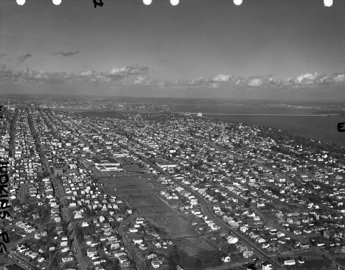
Built on the site of a former ravine landfill that was used for about four decades, Judkins Park was transferred to the parks department in the late 1940s and early 1950s, and opened to the public on October 8, 1977, according to a story in the October 6 issue of The Seattle Times.
Aerial view of Judkins Park and Playfield, 1965. Courtesy of the Seattle Municipal Archives, Identifier 29470. S Judkins Street is at bottom center and right, below the park. Washington Middle School is at the north end of the park and 23rd Avenue S is the arterial to its east. Lake Washington and the Evergreen Point Floating Bridge (Washington State Route 520) are visible in the distance.
Born and raised in Seattle, Benjamin Donguk Lukoff had his interest in local history kindled at the age of six, when his father bought him settler granddaughter Sophie Frye Bass’s Pig-Tail Days in Old Seattle at the gift shop of the Museum of History and Industry. He studied English, Russian, and linguistics at the University of Washington, and went on to earn his master’s in English linguistics from University College London. His book of rephotography, Seattle Then and Now, was published in 2010. An updated version came out in 2015.
For the origin of S Norman Street, we go back to our first street name post, SW Seattle Street, which read in part:
On August 4, 1869, Ike M. Hall — the executor of the estate of Norman B. Judkins — filed the Judkin’s (sic) Addition to the Town of Seattle, located just southwest of where the interchange between I-5 and I-90 is today. From north to south, the east–west streets are named Norman, B, Judkins, Addition, Town, and Seattle.
Today, S Norman Street begins on the other side of Beacon Hill, the portion shown above having been obliterated by King County Metro’s Atlantic Base and Interstate 5. (In fact, S Addition Street is the only one remaining in its original location, Judkins Street now starting on Beacon Hill and Seattle Street only existing in West Seattle.) Beginning at Poplar Place S just east of Interstate 90, it goes for a block northeast to Rainier Avenue S. It picks up again at Davis Place S and S Bush Place and goes a block east to 21st Avenue S. Resuming at 22nd Avenue S, just east of Judkins Park (also named for Norman B. Judkins), it goes ⅗ of a mile east to 33rd Avenue S, with only two short interruptions:
An unimproved stretch south of St. Gebriel Ethiopian Orthodox Church between 26th Avenue S and Martin Luther King Jr. Way S: what looks to be a bramble patch followed by a driveway for some townhouses; and
A stairway from 31st Avenue S to half a block west of 32nd Avenue S.
There appears to be a privately maintained stairway from 33rd Avenue S down to Lake Washington Boulevard S, and the next block is completely unimproved, though in both cases neighbors appear to be incorporating the right-of-way into their yards and driveways. Finally, there is a short stretch of Norman Street east of Lakeside Avenue S that turns into a shoreline street end on Lake Washington — one of Leschi’s String of Pearls.
King County Parcel Viewer showing S Norman Street between 26th Avenue S and Martin Luther King Jr. Way S. What appears to be a private driveway from Martin Luther King is actually public right-of-way.King County Parcel Viewer showing S Norman Street from 33rd Avenue S to Lake Washington. The private driveway in the public right-of-way east of Lake Washington Boulevard S (center of image) is easily visible, as is the shoreline street end east of Lakeside Avenue S.
Born and raised in Seattle, Benjamin Donguk Lukoff had his interest in local history kindled at the age of six, when his father bought him settler granddaughter Sophie Frye Bass’s Pig-Tail Days in Old Seattle at the gift shop of the Museum of History and Industry. He studied English, Russian, and linguistics at the University of Washington, and went on to earn his master’s in English linguistics from University College London. His book of rephotography, Seattle Then and Now, was published in 2010. An updated version came out in 2015.
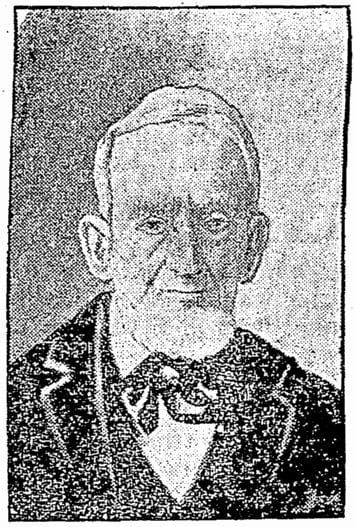
John Pike, from his obituary in the November 22, 1903, issue of The Seattle Times
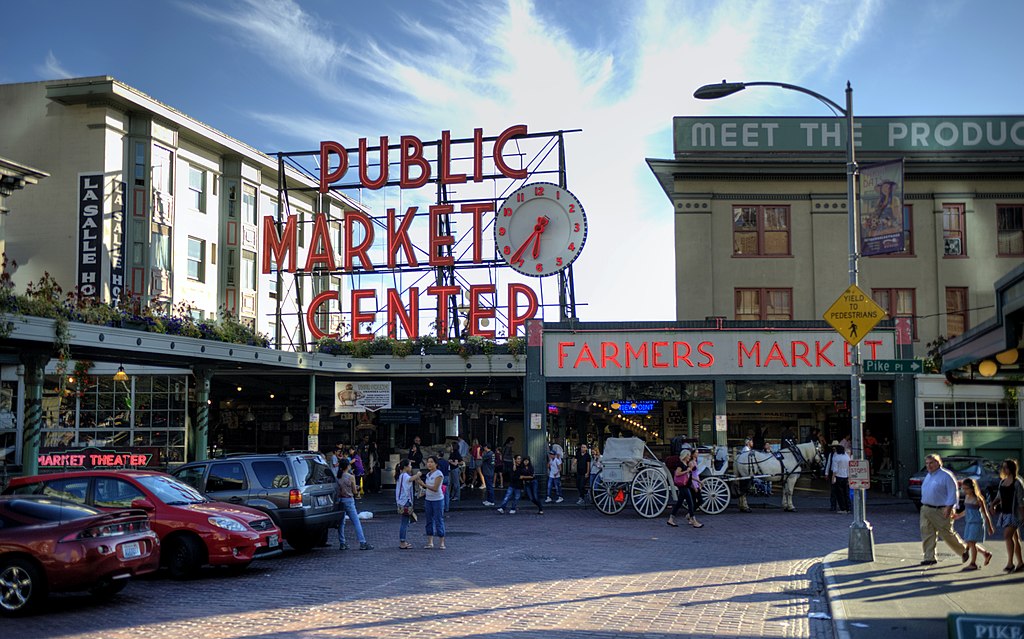
In the original plat, Pike Street (as well as Union and Pine Streets) begins at Front Street — today’s 1st Avenue — but today it begins on the Elliott Bay waterfront at Alaskan Way as the Pike Street Hillclimb. Pike Street proper begins at Pike Place (home of the eponymous market) and Post Alley (underneath the Market Theater sign), both shown below, and makes it a full 1⅔ miles to just past 18th Avenue in the Central District before being interrupted. It then resurfaces at 23rd Avenue and goes another ⅘ of a mile to Grand Avenue in Madrona, a few blocks east of Lake Washington.
Born and raised in Seattle, Benjamin Donguk Lukoff had his interest in local history kindled at the age of six, when his father bought him settler granddaughter Sophie Frye Bass’s Pig-Tail Days in Old Seattle at the gift shop of the Museum of History and Industry. He studied English, Russian, and linguistics at the University of Washington, and went on to earn his master’s in English linguistics from University College London. His book of rephotography, Seattle Then and Now, was published in 2010. An updated version came out in 2015.
King Street is another of the first streets platted in Seattle by David Swinson “Doc” Maynard in May 1853. It was named after William Rufus DeVane King, a slaveholding Unionist Democratic politician who founded and named Selma, Alabama; was a senator from Alabama from 1819 to 1844 and from 1848 to 1852 (he was ambassador to France in the interim); and was vice president under Franklin Pierce for 45 days in 1853 (he died two days after he returned to the U.S. from Cuba, where he had been convalescing from tuberculosis; King Street was named in his honor 35 days after that).
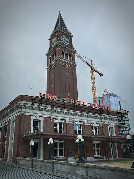
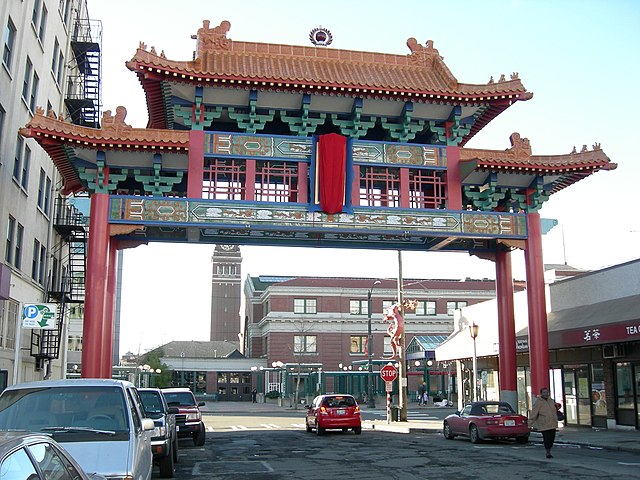
S King Street begins on the Elliott Bay waterfront at Alaskan Way S and runs ¼ of a mile to King Street Station just past 2nd Avenue S. It resumes at at 5th Avenue S, where it is spanned by the Historic Chinatown Gate, then makes it a full mile to 20th Avenue S, passing through Chinatown and Little Saigon along the way. East of there it exists in various segments, none of which is longer than ⅓ of a mile, and it finally ends at Lakeside Avenue S, where it is one of the String of Pearlsshoreline street ends.
Born and raised in Seattle, Benjamin Donguk Lukoff had his interest in local history kindled at the age of six, when his father bought him settler granddaughter Sophie Frye Bass’s Pig-Tail Days in Old Seattle at the gift shop of the Museum of History and Industry. He studied English, Russian, and linguistics at the University of Washington, and went on to earn his master’s in English linguistics from University College London. His book of rephotography, Seattle Then and Now, was published in 2010. An updated version came out in 2015.
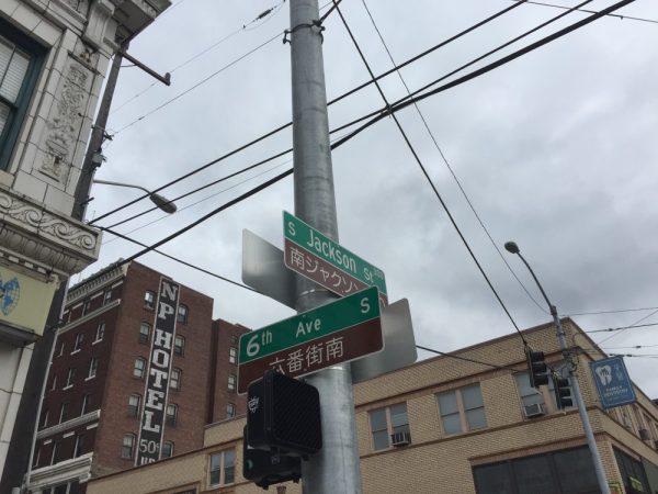
S Jackson Street begins today at Alaskan Way S on the Elliott Bay waterfront and has an uninterrupted 2-mile run as an arterial to 31st Avenue S in Leschi. On the other side of Frink Park, it makes its way the few remaining blocks to Lake Washington as a minor arterial, then a staircase, then a minor street, and finally a shoreline street end, part of the String of Pearls.
Born and raised in Seattle, Benjamin Donguk Lukoff had his interest in local history kindled at the age of six, when his father bought him settler granddaughter Sophie Frye Bass’s Pig-Tail Days in Old Seattle at the gift shop of the Museum of History and Industry. He studied English, Russian, and linguistics at the University of Washington, and went on to earn his master’s in English linguistics from University College London. His book of rephotography, Seattle Then and Now, was published in 2010. An updated version came out in 2015.
Weller Street was among the first streets platted in Seattle by David Swinson “Doc” Maynard in May 1853. It was named after John B. Weller, Democratic senator from California from 1852 to 1857 (Maynard named four streets in his plat after prominent Democratic politicians). Though he wasn’t a slaveowner like President Andrew Jackson or Vice President William R. King, or a future secessionist like Joseph Lane, who was the Southern Democrats’ nominee for vice president in 1860, he was a pro-slavery “Lecompton Democrat” who planned to have California become independent in case of civil war.
S Weller Street begins today at 5th Avenue S and runs ¼ of a mile through the Chinatown–International District to just east of 8th Avenue S, where it, like S Lane Street, is blocked by Interstate 5. It resumes at 10th Avenue S and runs ¾ of a mile to its end at 20th Place S and Washington Middle School.
Born and raised in Seattle, Benjamin Donguk Lukoff had his interest in local history kindled at the age of six, when his father bought him settler granddaughter Sophie Frye Bass’s Pig-Tail Days in Old Seattle at the gift shop of the Museum of History and Industry. He studied English, Russian, and linguistics at the University of Washington, and went on to earn his master’s in English linguistics from University College London. His book of rephotography, Seattle Then and Now, was published in 2010. An updated version came out in 2015.
Lane Street was another one of Seattle’s first streets, platted on May 23, 1853 by David Swinson “Doc” Maynard. It was named after Joseph Lane, governor of Oregon Territory (which then included what is now Washington) from March 1849 to June 1850. Ten years later, he was the pro-slavery, pro-secession Southern Democratic nominee for vice president, with John C. Breckenridge at the head of the ticket.
S Lane Street begins today at 6th Avenue S just east of the flagship Uwajimaya grocery store, and runs ⅕ of a mile through the Chinatown–International District to just east of 8th Avenue S, where it is blocked by Interstate 5. East of there, it is a path and stairway from 10th to 13th Avenues S, past which it appears in segments of varying lengths until it ends for good at Lakeside Avenue S.
Born and raised in Seattle, Benjamin Donguk Lukoff had his interest in local history kindled at the age of six, when his father bought him settler granddaughter Sophie Frye Bass’s Pig-Tail Days in Old Seattle at the gift shop of the Museum of History and Industry. He studied English, Russian, and linguistics at the University of Washington, and went on to earn his master’s in English linguistics from University College London. His book of rephotography, Seattle Then and Now, was published in 2010. An updated version came out in 2015.
Washington Street was one of Seattle’s first streets, platted on May 23, 1853 by David Swinson “Doc” Maynard and named after President George Washington. Its initial segment begins at Alaskan Way S on the Elliott Bay waterfront and ends half a mile to the east at Kobe Terrace Park. East of Interstate 5 it exists in a number of segments interrupted by schools and parks and finally ends at S Frink Place and Frink Park.
Born and raised in Seattle, Benjamin Donguk Lukoff had his interest in local history kindled at the age of six, when his father bought him settler granddaughter Sophie Frye Bass’s Pig-Tail Days in Old Seattle at the gift shop of the Museum of History and Industry. He studied English, Russian, and linguistics at the University of Washington, and went on to earn his master’s in English linguistics from University College London. His book of rephotography, Seattle Then and Now, was published in 2010. An updated version came out in 2015.
Madison Street — another of Seattle’s “first streets” — was named for James Madison, president of the United States from 1809 to 1817. It is the only street in town that stretches, uninterrupted, from the salt water of Elliott Bay and Puget Sound to the fresh water of Lake Washington.
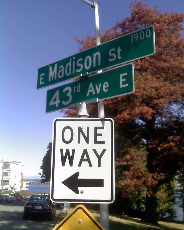
Originating as the McGilvra Road in 1861, Madison Street begins on the Elliott Bay waterfront at Alaskan Way and ends 3¾ miles northeast of there at a small fishing pier, just east of 43rd Avenue E and north of Madison Park Beach. Apart from a slight bend to the northeast at 22nd Avenue, it is as straight as an arrow from beginning to end.
Born and raised in Seattle, Benjamin Donguk Lukoff had his interest in local history kindled at the age of six, when his father bought him settler granddaughter Sophie Frye Bass’s Pig-Tail Days in Old Seattle at the gift shop of the Museum of History and Industry. He studied English, Russian, and linguistics at the University of Washington, and went on to earn his master’s in English linguistics from University College London. His book of rephotography, Seattle Then and Now, was published in 2010. An updated version came out in 2015.


.jpg)
.jpg)