Montana Circle

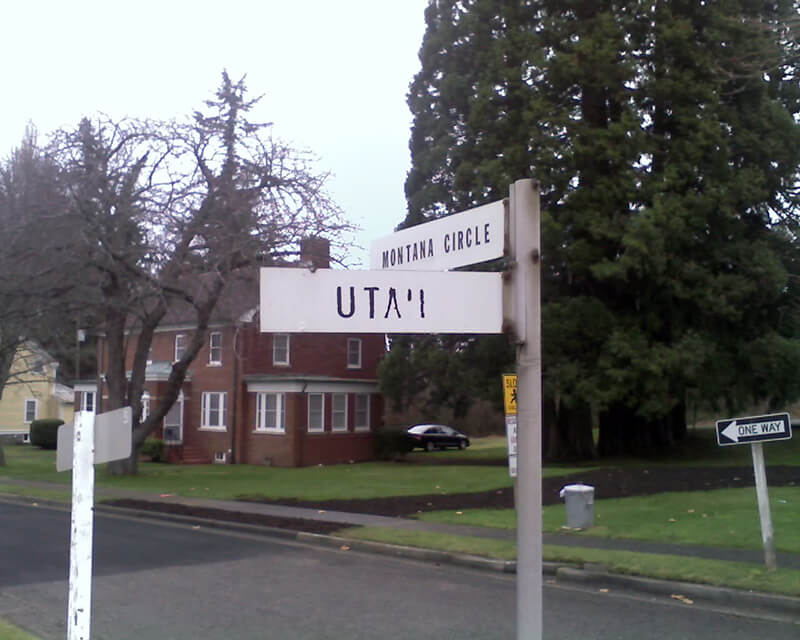
Like almost every other street in Fort Lawton (1900−2011), which became Discovery Park, Montana Circle was named after a state of the Union. Unlike almost every other street in Discovery Park, however, Montana Circle is a private road and in fact not part of the park at all. This is because the houses here, originally built for non-commissioned officers, were in use as military housing at the time the Army officially closed the fort. According to Monica Wooton of the Magnolia Historical Society, writing in the Queen Anne & Magnolia News, this meant that the property had to be sold at market rate instead of returned to the city as surplus, as most of the rest of the park had been. The city did manage to come up with $11 million to demolish some non-historic housing and restore the forest, but

Friends of Discovery Park could not get a partnership with government and other entities needed to purchase the Officer’s Row and NCO housing because of the cost mandated by the Privatization Act [while] the economic recession was taking hold.

As the Seattle Daily Journal of Commerce reported in April 2016,

The 13 homes in Montana Circle at Fort Lawton all have sold in about three months, and prices on the ones that have closed average $484 a square foot. Prices ranged from $799,000 to $1,050,000.

This provided a nice profit for the real estate firm that bought Officer‘s Row and Montana Circle from the military for $9.5 million.

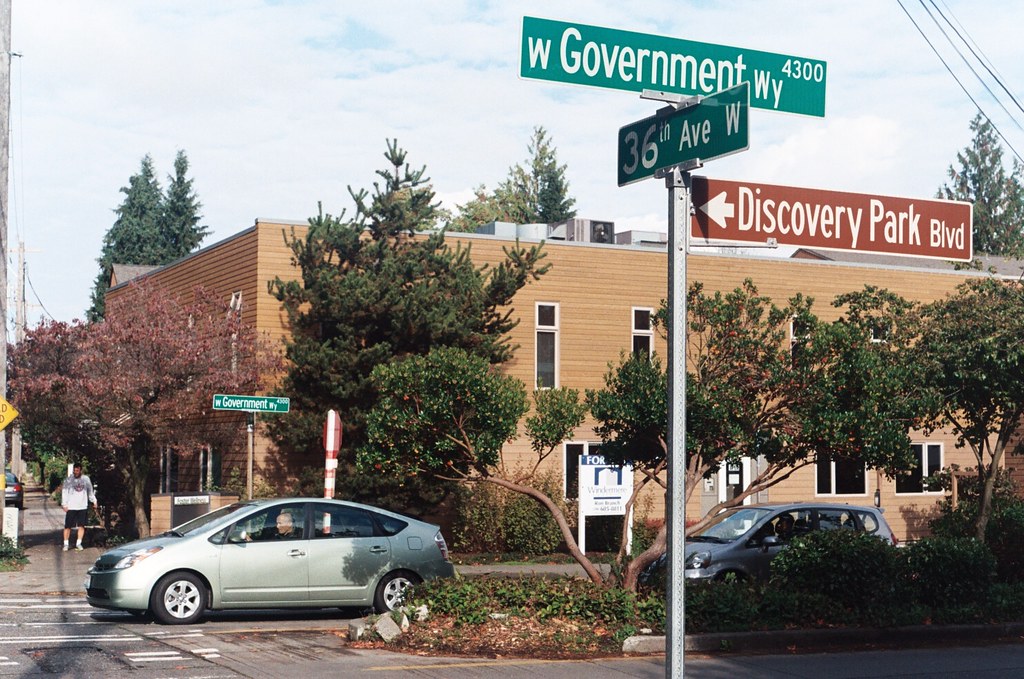
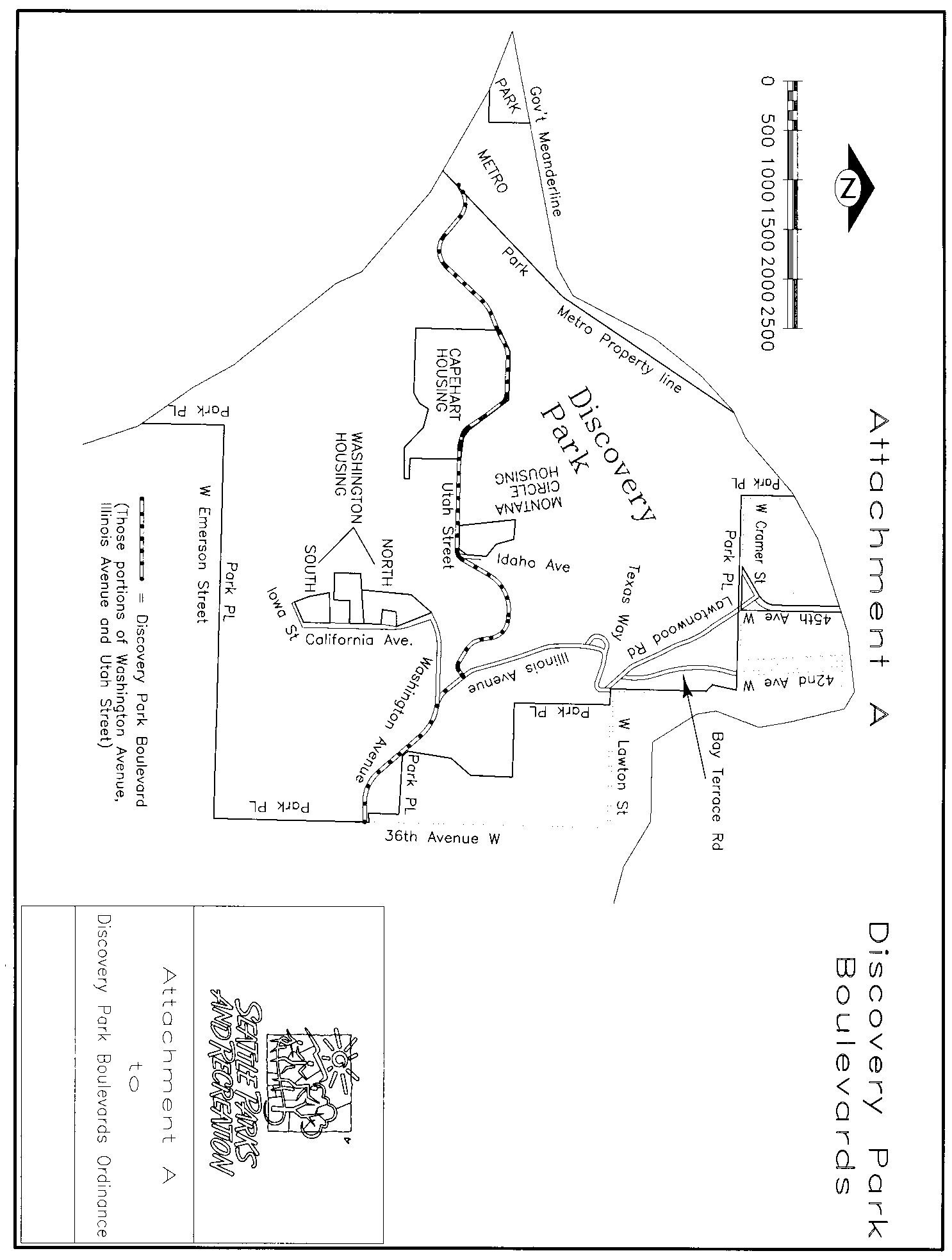
Montana Circle begins at Discovery Park Boulevard just east of Kansas Avenue and loops around to rejoin Discovery Park Boulevard around 100 feet to the east.

Street sign at corner of Montana Circle and Utah Street, January 15, 2011
Street sign at corner of Montana Circle and Utah Street (now Discovery Park Boulevard), January 15, 2011. Photograph by Benjamin Lukoff. Copyright © 2011 Benjamin Lukoff. All rights reserved.

Bernie Whitebear Way

This Discovery Park road was named for Bernie Whitebear (1937–2000), a Native American activist who co-founded the Seattle Indian Health Board, the United Indians of All Tribes Foundation, and the Daybreak Star Indian Cultural Center. Originally part of Illinois Avenue, this portion of the street was renamed for Whitebear in 2011. (Like all streets in Discovery Park except for 45th Avenue W, Bernie Whitebear Way has no directional designation.)

Today, Bernie Whitebear Way begins at Texas Way and Illinois Avenue and goes ½ a mile northwest, then west, to Daybreak Star.

Bernie Whitebear and Senator Henry Jackson
Bernie Whitebear speaking to Senator Henry M. Jackson during the Daybreak Star lease signing ceremony, November 14, 1971. Courtesy of the Seattle Municipal Archives, Identifier 193058
Signs at corner of Texas Way and Bernie Whitebear Way, October 30, 2011
Signs at corner of Texas Way and Bernie Whitebear Way, October 30, 2011. Photograph by Benjamin Lukoff. Copyright © 2011 Benjamin Lukoff. All rights reserved.

Texas Way

As I note in Illinois Avenue, most streets in Fort Lawton (1900−2011), which became Discovery Park, were named after states, and this one is no exception. According to this map, the southernmost part of what is now Texas Way was originally Indiana Avenue and Delaware Avenue — the three were consolidated some time before 1967, when this map was made by the Fort Lawton Office of the Post Engineer. (As with Illinois Avenue and every other street in Discovery Park except for 45th Avenue W, Texas Way has never carried a directional designation.)

Street sign at corner of Texas Way and Discovery Park Boulevard, October 30, 2011
Street sign at corner of Texas Way and Discovery Park Boulevard, October 30, 2011. Photograph by Benjamin Lukoff. Copyright © 2011 Benjamin Lukoff. All rights reserved.

Today, Texas Way begins as a pathway south of the Discovery Park playground and goes ¼ of a mile east, then north, to 36th Avenue W just south of its intersection with Discovery Park Boulevard and W Government Way. It resumes as a paved road just to the north at Discovery Park Boulevard and goes just over ⅔ of a mile north, then northwest, to Illinois Avenue at the entrance to the park’s North Parking Lot. Here, it once again becomes a pathway and continues another ¾ of a mile northwest, then south, to rejoin Discovery Park Boulevard just west of the Utah Wetlands.

Signs at corner of Texas Way and Bernie Whitebear Way, October 30, 2011
Signs at corner of Texas Way and Bernie Whitebear Way, October 30, 2011. Photograph by Benjamin Lukoff. Copyright © 2011 Benjamin Lukoff. All rights reserved.

Illinois Avenue

This street, like most others in Fort Lawton (1900−2011), which is now Discovery Park, was named by the United States Army after a state of the Union. I am not sure when the post’s streets were so named or who made the decision, but it can have been no later than 1944, when this map was made by the Army Corps of Engineers. (Here’s a much higher-resolution version from the Seattle Municipal Archives, created in 1973 but based on the older map.) One can see there that what are today Illinois Avenue and Bernie Whitebear Way were originally Vermont Way, Illinois Street, Lawton Road, and Florida Avenue. At some point before 1967 (see this map made by the Fort Lawton Office of the Post Engineer) the four were combined, and in 2011 the middle portion was renamed after Native American activist Bernie Whitebear.

Sign at corner of Illinois Avenue and Texas Way (mislabeled as Kansas Avenue), Discovery Park, October 30, 2011
Sign at corner of Illinois Avenue and Texas Way (mislabeled as Kansas Avenue), Discovery Park, October 30, 2011. Photograph by Benjamin Lukoff. Copyright © 2011 Benjamin Lukoff. All rights reserved.

Today, the eastern section of Illinois Avenue begins at Discovery Park Boulevard and goes ¼ of a mile north to Texas Way, where it turns into Bernie Whitebear Way. (Except for 45th Avenue W, no street in Discovery Park carries directional designations, nor did they when it was still a fort.) The western section, which is closed to traffic, begins at Texas Way and Discovery Park Boulevard and goes ¼ mile north to connect with footpaths that themselves connect to the North Beach Trail.

Discovery Park Boulevard

Unlike Seattle’s other park boulevards, Discovery Park Boulevard is of recent creation. Ordinance 122503, passed in 2007, designated numerous streets within the park as park boulevards, one reason being that:

Public safety will be enhanced within Discovery Park as traffic codes and regulations are fully enforceable on Park Boulevards as they are on City of Seattle streets, but not necessarily on park roads which are considered “private.”

(More on this at Lawtonwood Road.) Among the streets so designated were Lawtonwood Road, Bay Terrace Road, Utah Street, Washington Avenue, California Avenue, Iowa Street, Illinois Avenue, Texas Way, Idaho Avenue, and 45th Avenue W. The ordinance specified that Washington Avenue from the park entrance to Illinois Avenue; Illinois Avenue from there to Utah Street; and Utah Street from there to King County’s West Point Treatment Plant were to be known as Discovery Park Boulevard (see this map for an illustration).

Discovery Park Boulevard, June 28, 2020
Discovery Park Boulevard, June 28, 2020. Photograph by Flickr user Neil Hodges, licensed under Creative Commons Attribution-NonCommercial-ShareAlike 2.0 Generic

The park itself, 534 acres in the northwest corner of the Magnolia neighborhood, is the largest in Seattle. Opened in 1973, it occupies most of what was once Fort Lawton (1900–2011). It is said to have been named for HMS Discovery, Captain George Vancouver’s ship during the expedition that explored (and named) Puget Sound in 1792. However, according to “Discovery Park: A People’s Park in Magnolia,” a chapter from Magnolia: Memories & Milestones (2000),

The person who first suggested the name “Discovery Park” was U.S. District Judge Donald S. Voorhees, who had led the effort to create a park at Fort Lawton in 1968…. Voorhees was a student of Puget Sound history and Vancouver’s exploration. But he was also an avid follower of the philosophy of Frederick Law Olmsted, the famed American landscape architect. Voorhees believed the name combined the history of Vancouver’s exploration of Puget Sound on the HMS Discovery with the excitement of visitors when they discover the wonders of nature in the Park. When asked to make a choice between the meanings, Voorhees would choose the experience of “discovery” by citizens, particularly children, visiting the Park for the first time, over the historical connection with the HMS Discovery.

Street sign at the corner of W Government Way, 36th Avenue W, and Discovery Park Boulevard, October 30, 2011. Photograph by Benjamin Lukoff. Copyright © 2011 Benjamin Lukoff. All rights reserved.

Albert Place W

Our first paper street, W Semple Street, was in Magnolia, and so is our second!

In 1907, Anna Sophia Brygger (1852–1940) (NW Brygger Place, Brygger Drive W) filed the plat of Lawton Heights in Magnolia. Because a good portion of it was taken up by what is now known as Kiwanis Ravine, many of the streets were only partially built (Fort Place, 35th Avenue W, 34th Avenue W, Brygger Drive) or never built at all (Northview Place, Albert Street [Alberta is a typo], Byers Place). For some reason, they have never been vacated, making them all paper streets, and unlike W Semple Street, they don’t even have any buildings with addresses.

Brygger had seven children, one of whom was named Albert (1887–1977). According to Paul Dorpat, he was at one point president of Peoples National Bank (now part of U.S. Bank). It seems a fair bet that she named Albert Street after him.

Map of Lawton Heights Addition, Magnolia, 1912 Baist Atlas

W Semple Street

This “street” in the Lawtonwood neighborhood of Magnolia was created in 1895 as part of the Seattle Tide Lands plat. It appears to have been named after Eugene Semple (1840–1908), territorial governor from 1887 to statehood in 1889, and member of the state board of harbor line commissioners after his unsuccessful bid to become the state’s first governor. The same year the plat was filed, he began work on his project to dig a canal from Elliott Bay at the mouth of the Duwamish River to Lake Washington, which never made it through Beacon Hill and was eventually abandoned in the face of opposition from the backers of what became the Lake Washington Ship Canal.

Eugene Semple
Eugene Semple

“Street” appears above in quotation marks because there is no W Semple Street — not a physical one, anyway, making Semple a paper street. It does, however, still exist as a public right-of-way, as do most of the other streets on the plat, whether or not they were built. (As anyone who has been to Magnolia knows, its tidelands — intended to become industrial land as part of the rejected Bogue Plan — were never filled in, with the late exception of the Elliott Bay Marina.) Three residences even have a W Semple Street address, though they are only accessible from a private roadway off 45th Avenue W.

As can be seen below in the North Magnolia section of the plat map, a great many blocks were created as part of the process. Most of the unfilled tidelands are owned by the city (many of them forming Magnolia Tidelands Park), but some of the lots remain to this day in private ownership. There have been attempts to build on them, but none recently, and I can’t imagine such a thing being permitted in the future. So W Semple Street is likely to remain one of the few unbuilt streets in this plat to have addresses, and W Cole Street, Puget Avenue W, West Point Avenue W, and their ilk will forever remain streets on paper only.

North Magnolia section of Seattle Tide Lands as Surveyed and Platted by the Board of Appraisers of Tide and Shore Lands for King County, Washington, 1895

W View Place

W View Place, formerly an unnamed block-long alley between 28th Avenue W and 29th Avenue W just south of W Elmore Place, was named in 1950 at the request of Norman E. Boor, et al. The houses at 2805, 2815, and 2829 were all built in 1947, according to county records; I suppose this necessitated that the street be named, and for some reason no one could come up with anything more interesting than “View,” for the view of Ballard residents were able to enjoy.

Given the choice between W Boor Place and W View Place, I’d take the latter, but really… I’m surprised this was approved, especially given the existence of View Avenue NW near Golden Gardens Park.

Bay Terrace Road

To reach their homes, residents of Bay Terrace — east of Lawtonwood and west of Land’s End at the northern tip of Magnolia — must drive through Discovery Park. Within the park, their street (the narrow neighborhood only has one) is known as Bay Terrace Road, but changes to 42nd Avenue W north of the park boundary. Similarly to Lawtonwood Road, it does not appear to have been officially so designated until 2007, when ordinance 122503 was passed. Also similarly to Lawtonwood Road, it carries no directional designation, since it is a park boulevard.

Bay Terrace Road runs ¼ mile north from Lawtonwood Road just west of 40th Avenue W, and then becomes 42nd Avenue W, which continues on for another ⅕ of a mile to a viewpoint overlooking Shilshole Bay.

Sign for Bay Terrace Road, Discovery Park, October 30, 2011
Sign for Bay Terrace Road, Discovery Park, October 30, 2011. Photograph by Benjamin Lukoff. Copyright © 2011 Benjamin Lukoff. All rights reserved.

Lawtonwood Road

Lawtonwood Road is one of the many Magnolia streets, like W Government Way, W Fort Street, and W Lawton Street, related to Fort Lawton, which was opened by the U.S. Army in 1900 and is now Discovery Park. (The fort itself was named for Major General Henry Ware Lawton [1843–1899]). It runs ⅓ of a mile northwest from 40th Avenue W to the intersection of 45th Avenue W and W Cramer Street.

Street sign at the corner of Lawtonwood Road, W Lawton Street, and 40th Avenue W, October 30, 2011
Street sign at the corner of Lawtonwood Road, W Lawton Street, and 40th Avenue W. Photograph by Benjamin Lukoff, October 30, 2011. Copyright © 2011 Benjamin Lukoff. All rights reserved.

The neighborhood of Lawtonwood, or Lawton Wood — both spellings have been in use over the years — is perched atop Discovery Park north of W Cramer Street. Lawtonwood Road, which goes through the park, is the only way in or out. It would have been a natural part of Fort Lawton, and it certainly would have made a great addition to the park, but as local historian Paul Dorpat explains in his introduction to the neighborhood

Steady white settlement started in 1875 when German immigrant Christian Scheuerman moved to the area, cleared the timber and married a native woman who had ten children before she died in 1884. In 1895 Seattle boosters organized to attract a military post to the area and gathered the acreage that is now Fort Lawton–Discovery Park. The part of it that is now Lawton Wood… is not part of the military holding because Scheuerman withheld it.

It should not be thought that Scheuerman cared nothing at all for the defense of Seattle — he and his family did donate 26.13 acres to the cause — though that made up less than 4% of the 704.21 acres given in total. (The single largest contributors of land were Thomas W. Prosch and his wife, Virginia, who gave 330.97 acres, a full 47%.)

Dorpat continues:

Soon after the military moved in next door, this protected enclave was improved with mansions of a few of Seattle’s elite. In 1952 these neighbors — about 30 houses sparingly distributed about a generous 30 acres – organized the Lawton Wood Improvement Club, waving the motto “To Beautify and Develop Lawton Wood.” By the time that the last of the Scheuermans, Ruby, moved out in the late 1970s, the beautifying had turned more to developing, and the lots got smaller.

The first reference to Lawtonwood Road I was able to find in The Seattle Times or the Seattle Post-Intelligencer is from 1935, but it does not appear to have been officially so designated until 2007. According to ordinance 122503, park roads “are considered ‘private’” — technically residents of Lawtonwood and Bay Terrace had no legal right to transit the park to reach their homes, though of course they had never been prevented from doing so. To rectify this and other issues, and in anticipation of the privatization of the residences on Officers’ Row and Montana Circle, the ordinance made Lawtonwood Road, Bay Terrace Road, Utah Street, Washington Avenue, California Avenue, Iowa Street, Illinois Avenue, Texas Way, Idaho Avenue, and 45th Avenue W “public park boulevards.”

Note, by the way, that none of these streets except 45th Avenue W contain a directional designation. Ordinarily one would expect to see W Lawtonwood Road, or Lawtonwood Road W, but park roads in Seattle carry no directional designation. An exception seems to have been made for 45th Avenue W, presumably because a numbered avenue with no directional designation “belongs” in Madrona or Leschi, seven miles to the southeast.

Scheuerman Creek just east of 45th Avenue W in the Lawtonwood neighborhood. 45th Avenue W is part of Discovery Park, but the creek is on private property. Photograph by Benjamin Lukoff, January 31, 2021. Copyright © 2021 Benjamin Lukoff. All rights reserved.
Scheuerman Creek just east of 45th Avenue W in the Lawtonwood neighborhood. As noted above, 45th Avenue W is part of Discovery Park, but the creek is on private property. Photograph by Benjamin Lukoff, January 31, 2021. Copyright © 2021 Benjamin Lukoff. All rights reserved.

W Lawton Street

Lawton Street originated as Lawton Place in the 1905 plat of Lawton Park, an Addition to the City of Seattle. Like Government Way and Fort Street, it was named for its proximity to Fort Lawton, which had been opened by the U.S. Army in 1900. The fort itself was named for Major General Henry Ware Lawton (1843–1899), who was killed in December 1899 in the Battle of Paye of the Philippine–American War.

The bulk of W Lawton Street comes not from the Lawton Park plat, which covered 34th Avenue W to 36th Avenue W, but from a grant from the federal government in 1909 for sewer and street purposes. Lawton Street was laid out along the north edge of the fort, from its northwest corner at 36th Avenue W to what is now 40th Avenue W. There is a short discontinuity beginning about 250 feet east of 40th Avenue W consisting of a footpath and stairs; I’m not sure when that was created, but I don’t think it was the original configuration, as that would have defeated the purpose of the street.


W Fort Street

Fort Street originated as Fort Place in the 1905 plat of Lawton Park, an Addition to the City of Seattle. It originally formed part of the “government roadway leading from the east boundary of the military reservation of Fort Lawton,” but in 1961 four of its blocks were officially renamed W Government Way. What remains today is a one-block stretch between 36th Avenue W and 35th Avenue W, a three-block stretch between Kiwanis Memorial Reserve Park and 32nd Avenue W, and a bridge over the BNSF Railway tracks from 28th Avenue W and Gilman Avenue W to 27th Avenue W.

W Government Way

In 1897 a number of Magnolia landowners deeded to the federal government land for “a government roadway leading from the east boundary of the military reservation of Fort Lawton,” which was to open in 1900, to a wharf at what is now 27th Avenue W and W Commodore Way. At some point between then and 1907, when it appears in in the plat of Lawton Heights, an Addition to the City of Seattle, filed by Anna S. Brygger (see Brygger Drive W and NW Brygger Place), it became known as Government Way. (There are similarly named streets in Spokane leading to the former Fort George Wright and in Coeur D’Alene, Idaho, leading to the former Fort Sherman.)  

The street was initially known as Government Way only from 32nd Avenue W to the east gate of the fort at 36th Avenue W (now the main entrance to Discovery Park), but in 1961 the name was extended to cover 32nd Avenue W north to W Fort Street as well as W Fort Street east to Gilman Avenue W, so today its length is about ½ a mile in total.

Street sign at the corner of W Government Way, 36th Avenue W, and Discovery Park Boulevard, October 30, 2011. Photograph by Benjamin Lukoff. Copyright © 2011 Benjamin Lukoff. All rights reserved.

W Bertona Street

This street, as with Dravus Street, was created in 1888 as part of Denny & Hoyt’s Addition to the City of Seattle, Washington Territory, and is also is part of a series of streets — Aetna, Bertona, Cremona, Dravus, Etruria, and Florentia — that appear in alphabetical order and have the common theme of being locations in Italy. Montebello di Bertona (Mundibbèlle in the Abruzzese dialect) is a small town in Pescara, Abruzzo, located near Mt. Bertona.

Technically, W Bertona Street begins as Bertona Street at the Ship Canal Trail around 80 feet east of Queen Anne Avenue N, but both streets there are little more than parking aisles nestled up against Seattle Pacific University’s Wallace Field. W Bertona begins in earnest at W Nickerson Street and goes ¾ of a mile west to 14th Avenue W, where it becomes a block-long stairway to 15th Avenue W. On the other side of 15th, it goes two more blocks before being stopped by the BNSF Railway tracks at 17th Avenue W; on the other side of the tracks it goes ⅗ of a mile west from 20th Avenue W to 30th Avenue W, becoming a stairway again for a block just about halfway. As with its Magnolia partner W Dravus Street, it’s ⅓ of a mile from 31st Avenue W to 36th Avenue W, where it becomes a stairway for a block, and then ½ a mile more from 37th Avenue W to 45th Avenue W. There is finally a 300-foot-long segment west of Perkins Lane W, where the roadway ends. (There is a shoreline street end beyond that, but it is currently inaccessible.)

Bertona Street east of Queen Anne Avenue N, November 2021
Bertona Street east of Queen Anne Avenue N, November 2021. The 2 Nickerson Street office building is at right; the row of trees is between the Ship Canal Trail and the Fremont Cut. Fremont and the Aurora Bridge are visible in the distance. Photograph by Benjamin Lukoff. Copyright © 2021 Benjamin Lukoff. All rights reserved.

Dravus Street

This street was created in 1888 as part of Denny & Hoyt’s Addition to the City of Seattle, Washington Territory by Edward Blewett and his wife, Carrie, of Fremont, Nebraska, who had purchased the land a few months earlier from Arthur Denny and John Hoyt. According to Valarie Bunn in her article “Fremont in Seattle: Street Names and Neighborhood Boundaries,” Edward Corliss Kilbourne may have done much of the actual naming of streets as attorney-in-fact for the Blewetts.

Portion of plat map of Denny and Hoyt's Addition to the City of Seattle, Washington Territory (1888) showing Aetna, Bertona, Cremona, Dravus, Etruria, and Florentia Streets
Portion of plat map of Denny and Hoyt’s Addition to the City of Seattle, Washington Territory (1888) showing Aetna, Bertona, Cremona, Dravus, Etruria, and Florentia Streets

As can be seen in the plat map above, Dravus is part of a series of streets — Aetna, Bertona, Cremona, Dravus, Etruria, and Florentia — that appear in alphabetical order and have the common theme of being locations in Italy, which had been unified 17 years earlier. I have yet to find a connection between Denny, Hoyt, the Blewetts, or Kilbourne and Italy. The closest I’ve come is an item in the February 28, 1903, issue of The Seattle Mail and Herald, which reports that “on February 27, the Woman’s Century Club met and discussed the subject ‘Italian Art and Literature.’ Mrs. Bessie L. Savage and Mrs. E.C. Kilbourne [Leilla Shorey] prepared papers relating to these subjects.” I would love to find out if there’s anything more solid!

The Drava River, which originates in the Italian region of the South Tyrol, flows from there through Austria, Slovenia, and Croatia, forming much of the border between that country and Hungary, and joining the Danube on the Croatia–Serbia border. It was known as Dravus in Latin and Δράβος in Greek.

Dravus Street begins in the east at Nickerson Street and goes ⅗ of a mile west to 8th Avenue W and Conkling Place W. It resumes for half a block at 10th Avenue W, is briefly a foot path and stairway, and then is an arterial connecting Queen Anne and Magnolia via Interbay, going just over a mile from 11th Avenue W to 30th Avenue W. (This section was originally known as Grand Boulevard, and indeed W Dravus is double the width of the other streets in the area, though it features wide planting strips instead of a central median.) It’s ⅓ of a mile from 31st Avenue W to 36th Avenue W, where it becomes a stairway for a block, and then ½ a mile more from 37th Avenue W to just west of Magnolia Boulevard W, where the roadway ends. (There is a shoreline street end off Perkins Lane W, but it is currently inaccessible.)

W Commodore Way

W Commodore Way, which runs 1⅓ miles along Salmon Bay from 21st Avenue W to 40th Avenue W, obviously has a nautical name, but is its backstory as simple as that, like NE Boat Street along Portage Bay? Or does it honor a particular person?

The only online mention I’ve seen of a possible specific referent of Commodore is in the Don Sherwood Parks History file for Commodore Park:

Who was particularly in mind when the street was named Commodore Way is not recorded. However, the choice of Commodore Peary’s flagship [the SS Roosevelt]… to participate in the dedication of the [Ballard] Locks is significant. Peary must have sailed from Seattle as the port nearest Alaska and the Arctic.

It’s a reasonable theory on its face, but there are some major flaws. The street was named in 1890 as part of Gilman’s Addition to the City of Seattle, when Peary was a lieutenant — 19 years before he reached the North Pole (supposedly) and 27 years before the Ballard Locks were dedicated. In addition, Peary’s port of departure was New York, not Seattle. It doesn’t seem possible Commodore Way was named for Robert E. Peary.

Rather, I think there’s good evidence it was named for James Dickinson Smith (1829–1909), commodore of the New York Yacht Club in 1882 and 1883 and president of the New York Stock Exchange in 1885 and 1886. In Men of Progress: Biographical Sketches and Portraits of Leaders in Business and Professional Life in and of the State of Connecticut (1898), they write that he “has a national and international reputation as a yachtsman, and is best known all over the world as Commodore James D. Smith.” But where is the connection to Seattle? And why Commodore Way instead of Smith Way?

James Dickinson Smith

I first became aware of Smith’s connection to Seattle when I came across this line in the March 30, 1890, issue of the Seattle Post-Intelligencer, while looking for a connection between Commodore and the Seattle, Lake Shore and Eastern Railway: “Mr. J.S. Dunham, treasurer of the Seattle, Lake Shore & Eastern, and Commodore Smith visited Snohomish yesterday.”

Portion of article mentioning Commodore Smith in March 30, 1890, issue of Seattle Post-Intelligencer
Item mentioning Commodore Smith in March 30, 1890, issue of Seattle Post-Intelligencer

Before I go too much farther, I should note that the landowners in the plat of Gilman’s Addition were listed as Dr. Henry A. Smith and Franklin M. Jones and his wife, Carrie B. Jones. Franklin was a member of the New York banking firm Jameson, Smith and Cotting, financiers of the business ventures of Daniel Hunt Gilman, including the Seattle, Lake Shore and Eastern Railway (SLS&E). Hence the search terms I’d been using at Washington Digital Newspapers

This article from the June 17, 1897, issue of the P-I also came up, further associating Commodore Smith (to distinguish him from Dr. Smith) with the SLS&E and with New York:

Portion of article mentioning Commodore Smith in June 17, 1897, issue of Seattle Post-Intelligencer

I then did some reading on Commodore Smith… but still wasn’t quite sure until I found this passage in Men of Mark in Connecticut: Ideals of American Life Told in Biographies and Autobiographies of Eminent Living Americans (1904): “Among his successful performances was the establishment, in 1865, of the banking firm of Jameson, Smith & Cotting, now the banking house of James D. Smith & Company.” So Commodore Smith was the Smith in Jameson, Smith and Cotting! If J.A. Jameson merited a street (W Jameson Street), surely so did Commodore Smith. And why Commodore Way instead of Smith Way? Because there was another Smith to be honored — Dr. Henry A. Smith (Smith Street, as well as Smith Cove).

It may not have been one of the great mysteries of the ages, but I do think I may have solved this one.

Gilman Avenue W

This street was named for Daniel Hunt Gilman (1845–1913), who among other things was one of the founders of the Seattle, Lake Shore and Eastern Railway (SLS&E) in 1885. The SLS&E is now part of the BNSF Railway, and its old right-of-way along the Lake Washington Ship Canal and Lake Washington is now the Burke–Gilman Trail.

Daniel Hunt Gilman, circa 1890

The street was created in 1890 as part of Gilman’s Addition to the City of Seattle by Dr. Henry A. Smith (Smith Cove) and Franklin M. Jones and his wife, Carrie B. Jones. Franklin was a member of the New York banking firm Jameson, Smith and Cotting, financiers of Gilman’s business ventures.

Today, Gilman Avenue W begins at 20th Avenue W and W Bertona Street and goes ⁹⁄₁₀ of a mile northwest to 28th Place W, where it becomes W Government Way. The right-of-way continues on from there, though, and there is a 120-foot-long segment between 32nd Avenue W and Gay Avenue W and then, on the other side of Kiwanis Memorial Preserve Park, another 120-foot-long segment at the end of 34th Avenue W.

Originally, Gilman Avenue W existed east of the railroad tracks as well, but that section, between 15th Avenue W and 11th Avenue W, was changed to Gilman Drive W in 1961.

Gilman's Addition to Seattle, 1890, two sheets stitched together
Gilman’s Addition to Seattle, 1890

W Grover Street

This Magnolia street, like W Tilden Street, was named by Dr. Francis G. Bryant as part of the 1877 Bay View Addition to the City of Seattle. As I noted in the Tilden Street article, he named his streets for prominent Democratic politicians of the era. Only Tilden and Grover remain. It would appear that the Grover in question was La Fayette Grover, governor of Oregon from 1870 to 1877 and senator from Oregon from 1877 to 1883.

As Wikipedia notes, “During the [disputed] 1876 presidential election, Oregon’s statewide result clearly favored Rutherford Hayes, but then-governor Grover claimed that elector John Watts was constitutionally ineligible to vote since he was an ‘elected or appointed official’. Grover substituted a Democratic elector in his place. The two Republican electors dismissed Grover’s action and each reported three votes for Hayes, while the Democratic elector, C. A. Cronin, reported one vote for Samuel Tilden and two votes for Hayes. The vote was critical because the electoral college without John Watts’s vote was tied 184–184.”

As it turns out, the election was ultimately awarded to Hayes as part of the Compromise of 1877, but it appears Governor Grover did his best to help his fellow Democrat. (There’s more about Oregon’s pivotal role in the Wilamette Week article “That One Time Oregon Decided the Presidential Election.”)

W Grover Street begins at 28th Avenue W at the entrance to Magnolia Manor Park, and runs a tenth of a mile west to 30th Avenue W. It then runs one more block from 31st Avenue W to 32nd Avenue W.

W Tilden Street

This Magnolia street was named by Dr. Francis G. Bryant as part of the 1877 Bay View Addition to the City of Seattle for Samuel J. Tilden, governor of New York from 1875 to 1876 and Democratic candidate for president in the election of 1876. The Compromise of 1877, according to Wikipedia, “resulted in the United States federal government pulling the last troops out of the South, and ending the Reconstruction Era. Through the Compromise, Republican Rutherford B. Hayes was awarded the White House over Democrat Samuel J. Tilden on the understanding that Hayes would remove the federal troops whose support was essential for the survival of Republican state governments in South Carolina, Florida and Louisiana.” The plat was filed on February 17 — while the Electoral Commission was in session and had not yet awarded the election to Hayes.

Of the other named streets in the Bay View Addition, only Grover remains, but most of them appear to be named for prominent Democratic politicians of the era (Jackson excepted, as he died 32 years earlier). I left off the two I could not associate with anyone (Randall, Nichols) and am not as sure about Williams as I am about the others:

As for Dr. Bryant, I was unable to find out much about him other than he was some sort of doctor and filed a patent in 1877 for a new type of fire escape.

W Tilden Street begins at 28th Avenue W and goes just about 1,000 feet west to 31st Avenue W, its last hundred feet being a footpath through the landscaped right-of-way. On the other side of the valley, there is a 225-foot-long segment from 37th Avenue W to 38th Avenue W.

Brygger Drive W

Anna Sophia Brygger, the Norwegian immigrant mentioned in NW Brygger Place, is also the namesake of Magnolia’s Brygger Drive W, a short street that runs not quite a tenth of a mile from 34th Avenue W just north of W Government Way to a dead end at Kiwanis Memorial Preserve Park. Many of the streets on the map below were either never built (Northview Place, Albert Street [Alberta is a typo], Byers Place) or were only partially built (Fort Place, 35th Avenue W, 34th Avenue W, and Brygger Drive itself.)

Map of Lawton Heights Addition, Magnolia, 1912 Baist Atlas