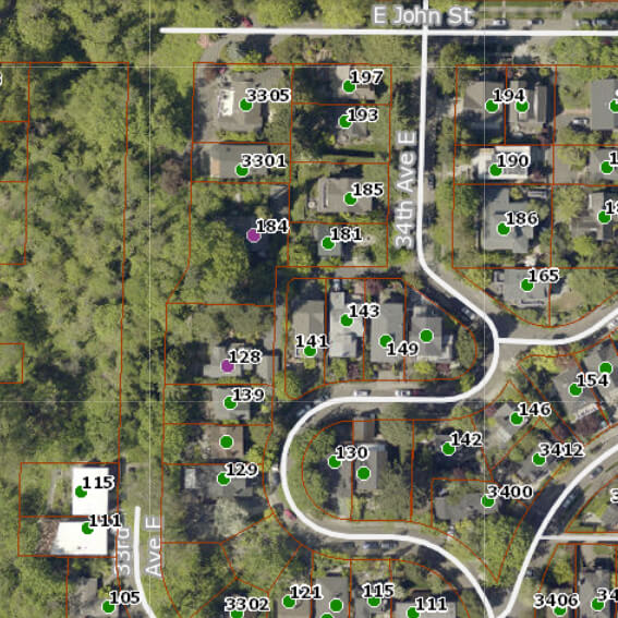
Officially, this alley off 34th Avenue E between E John Street and 35th Avenue E is unnamed. That proved inconvenient for Jack Sussman and Cathy Nunneley, who live at 184 and 128 33rd Avenue E, respectively. Yes, 33rd Avenue E, even though their house is accessed from 34th.
I don’t know how it works in other cities, but in Seattle, you can have an address on a nonexistent — or, more accurately, unimproved — street. This is the case with W Semple Street — the three residences with a Semple address are only accessible from 45th Avenue W. And this is the case here. Unlike Semple, 33rd Avenue E is improved… but not for the entire length of its right-of-way. From about 450 feet south of E Harrison Street to about 175 feet north of E Denny Way, 33rd Avenue E is unimproved and makes up part of the Harrison Ridge Greenbelt.
Sussman writes in the July–August 2010 issue of The Valley View, the newsletter of the Madison Valley Community Council:
We have a problem because our address is one that people cannot find. Get a new mailperson and we won’t see any mail for a week!… How many Roto-Rooter men, phone line fixers, and Craigslist contacts have been lost trying to find us? GPS and MapQuest systems are useless for locating my house. How many times have I run out to the street vainly searching for the delivery truck going round and round the neighborhood?
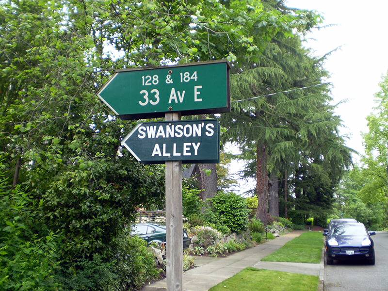
He goes on to explain that “a fine article lamenting [the] neglect of city alleys” written by Knute Berger inspired him to put up a sign reading “Swanson’s Alley” underneath the city’s official sign directing people to his and Nunneley’s houses. He chose the name to honor “Swanson, a Swedish carpenter, [who] lived here in the 1930s,” and happily reports that giving the alley a name, albeit unofficial, did indeed help people find his residence.
In the next issue of The Valley View, Sussman reports that he was able to locate a grandson of this Swanson, to give him the news and get further details on the alley’s namesake:
The grandfather who founded the family here was Elof Svenson [1881–1958]; the name later became Swanson in America. Elof was a teenage laborer, a Swedish immigrant who spoke little English. I had one detail wrong: he was not a carpenter but a landscape worker who specialized in rockeries. He put in all the bulkheads that hold the ground above the Harrison Greenbelt.
In general, I’m not a fan of unofficial signage (especially signs proclaiming public rights-of-way to be private, which I’ve come across in Blue Ridge, Montlake, and Wedgwood) but I have no problem with this one. It doesn’t imply private ownership and it’s meant to improve navigation. And it honors someone most people would otherwise never have heard of.
By the way — in case you’re wondering why Swanson’s Alley shows up in Google Maps and OpenStreetMap even though the name is unofficial, it’s because I added it. The name, that is — the alley was already present on both. (I’m trying to get it added to Apple Maps as well, but that may be a bit more difficult.)
Update, August 11, 2025: Two bits of news. First, it’s now appearing on Apple Maps! Second, and not as happy, I hear from neighbor Sanford Levy that the city has taken down the handmade sign. Apparently they were installing a No Parking sign on the other side of the post, and while doing that, the worker took the opportunity to remove the unauthorized one. Hopefully some solution can be reached, and I’ll update this post if and when that happens.
Born and raised in Seattle, Benjamin Donguk Lukoff had his interest in local history kindled at the age of six, when his father bought him settler granddaughter Sophie Frye Bass’s Pig-Tail Days in Old Seattle at the gift shop of the Museum of History and Industry. He studied English, Russian, and linguistics at the University of Washington, and went on to earn his master’s in English linguistics from University College London. His book of rephotography, Seattle Then and Now, was published in 2010. An updated version came out in 2015.


.jpg)