S Angeline Street

This street lies mostly in Columbia City, where its name originated, and Seward Park, with a few blocks in Beacon Hill and even fewer in West Seattle. It almost reaches Puget Sound at Beach Drive SW, and does reach Andrews Bay of Lake Washington at Lake Washington Boulevard S.

As noted, the name Angeline Street originated in Columbia City, in this 1891 Plat of Columbia, filed at the request of James Kippen Edmiston by Percy W. Rochester and John I. Wiley of the Washington Co-operative Home Company. 

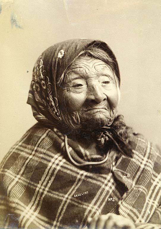
Princess Angeline was born Kikisoblu, the daughter of Si’ahl [siʔaɫ], better known in English as Chief Seattle of the Duwamish and Suquamish Tribes. Her date of birth is unknown; Wikipedia gives it as ca. 1820, whereas this article posted by the Duwamish Tribe, written by elementary school students based on HistoryLink essays, gives it as 1828. She died May 31, 1896.

Princess Angeline received her English name from Catherine Broshears Maynard, wife of David Swinson (“Doc”) Maynard, one of the earliest Seattle settlers. As the HistoryLink Elementary article puts it,

Chief Seattle’s oldest daughter was named Kikisoblu. She became friends with many of Seattle’s founding families. One of her friends was Catherine Maynard. She felt that Kikisoblu should have a name that would let the white settlers know that she was the daughter of a great chief. So she called her Princess Angeline. She thought that name was prettier than the name Kikisoblu.

Photograph of Kikisoblu, or Princess Angeline, by Frank La Roche, ca. 1893
Photograph of Princess Angeline (Kikisoblu), by Frank La Roche, ca. 1893

Cheasty Boulevard S

This Olmsted boulevard was designed in 1910 as Jefferson Boulevard, the entrance to Jefferson Park. It runs about 1⅕ miles from Beacon Avenue S and S Alaska Street in the southwest to S Winthrop Street in the northeast, which also forms part of the park boulevard. After crossing Martin Luther King Jr. Way S and Rainier Avenue S, it continues on as S Mount Baker Boulevard, ending at Mount Baker Park.

In 1914, it was renamed Cheasty Boulevard after E.C. (Edward) Cheasty (born 1864), who died that year. He had been police commissioner, commissioner of the Alaska–Yukon–Pacific Exposition, and a member of the park board from 1907 to 1910 and 1912 to his death, according to the Don Sherwood Park History Files. He also ran Cheasty’s Store, a downtown haberdashery, from 1888 until his death. 

E.C. Cheasty, photograph by Edward S. Curtis, from the University of Washington Libraries’ Portrait Collection

Speaking of his death, it sadly appears that it was due to suicide. He fell from the 10th floor of the Washington Hotel — the same hotel in which fellow businessman Frank B. Hubbell killed himself in 1905.

Seattle Star article on death of E.C. Cheasty
Front-page article on Cheasty’s death, The Seattle Star, June 13, 1914

S Dose Terrace

This street runs just about 1,000 feet from 31st Avenue S in the west to Colman Park in the east. West of 31st Avenue, it’s S Walker Street, and the right-of-way extends through the park to Lake Washington Boulevard S as the Dose Terrace steps.

The 1905 plat of C.P. Dose’s Lake Washington Addition to the City of Seattle has it as Walker Street from 30th Avenue S to the park, but its name was changed to Dose Terrace in 1911 after C.P. Dose, a real estate developer originally from Beckerwitz, Germany.

Office of C.P. Dose’s Lake Washington Addition, 1903, from University of Washington Libraries, Special Collections Division

Island Drive S

There are only a handful of islands within Seattle city limits, and of them just one — Harbor Island — is large enough to have streets on it. But Island Drive S isn’t on Harbor Island — rather, it’s along the shore of Lake Washington, 5½ miles to the southeast. What gives?

As it turns out, Island Drive once was on an island — Pritchard Island. Known as tleelh-chus (‘little island’) by the Duwamish tribe, it was bought in 1900 by Alfred J. Pritchard (grandfather of Joel Pritchard, who was a congressman from Washington state in the 1970s and 1980s and its lieutenant governor in the 1980s and 1990s). In 1916, Lake Washington was lowered by 9 feet as part of the construction of the Lake Washington Ship Canal, and Pritchard’s island became part of the mainland.

It’s still known as Pritchard Island, though. Today, Pritchard Island Beach, Rainier Beach Urban Farm and Wetlands, and Be’er Sheva Park separate the island from the mainland.