We no longer remember the exact circumstances that led to the naming. The fable is that Stroud earned the name by clearing the road, though. Originally one block long, the road was in Wood’s Green Lake Home Addition in 1892 (filed by later-mayor William Wood). Also in 1892 Fred worked for John Wallingford, whose daughter Emma was married to William Wood.
Today, Stroud Avenue N begins at E Green Lake Drive N and goes ¼ mile northeast, then north, to N 82nd Street.
Born and raised in Seattle, Benjamin Donguk Lukoff had his interest in local history kindled at the age of six, when his father bought him settler granddaughter Sophie Frye Bass’s Pig-Tail Days in Old Seattle at the gift shop of the Museum of History and Industry. He studied English, Russian, and linguistics at the University of Washington, and went on to earn his master’s in English linguistics from University College London. His book of rephotography, Seattle Then and Now, was published in 2010. An updated version came out in 2015.
Like most streets and walkways on the University of Washington campus, Pend Oreille Road NE is named after a Washington county — in this case, Pend Oreille County, which is located in the northeast corner of the state, bordering both Canada and Idaho. The county itself is named for the Pend d’Oreilles, an indigenous people of Eastern Washington, Idaho, and Western Montana.
It struck me as I was writing this post that I don’t know the history of how or when this decision was reached. I will look into this — if anyone has any insight, please let me know!
Pend Oreille Road NE is the east entrance to the university campus. It begins at 25th Avenue NE and NE 44th Street by University Village and goes ⅓ of a mile up the hill to E Stevens Way NE between Clark Hall, Communications Building, and Padelford Hall.
Born and raised in Seattle, Benjamin Donguk Lukoff had his interest in local history kindled at the age of six, when his father bought him settler granddaughter Sophie Frye Bass’s Pig-Tail Days in Old Seattle at the gift shop of the Museum of History and Industry. He studied English, Russian, and linguistics at the University of Washington, and went on to earn his master’s in English linguistics from University College London. His book of rephotography, Seattle Then and Now, was published in 2010. An updated version came out in 2015.
Corliss Avenue N begins at N Northlake Way on the borth shore of Lake Union and goes nearly a mile north through Wallingford to the Good Shepherd Center just north of N 46th Street. There is another stretch from N 59th Street to N 65th Street in Green Lake. North of the lake, Corliss goes nearly another mile from East Green Lake Drive N to N 92nd Street and the North Seattle College campus. There are a few more segments through Haller Lake, the longest one being ¾ of a mile long from N 130th Street to the city limits at N 145th Street. As with other North Seattle avenues, the name continues on into Shoreline; its northernmost appearance is at N 194th Street.
Born and raised in Seattle, Benjamin Donguk Lukoff had his interest in local history kindled at the age of six, when his father bought him settler granddaughter Sophie Frye Bass’s Pig-Tail Days in Old Seattle at the gift shop of the Museum of History and Industry. He studied English, Russian, and linguistics at the University of Washington, and went on to earn his master’s in English linguistics from University College London. His book of rephotography, Seattle Then and Now, was published in 2010. An updated version came out in 2015.
Stone Way N begins on the north shore of Lake Union at N Northlake Way and Waterway 22, and goes 1⅕ miles north to N 50th Street and Green Lake Way N. It forms an unofficial boundary between the Fremont and Wallingford neighborhoods.
Born and raised in Seattle, Benjamin Donguk Lukoff had his interest in local history kindled at the age of six, when his father bought him settler granddaughter Sophie Frye Bass’s Pig-Tail Days in Old Seattle at the gift shop of the Museum of History and Industry. He studied English, Russian, and linguistics at the University of Washington, and went on to earn his master’s in English linguistics from University College London. His book of rephotography, Seattle Then and Now, was published in 2010. An updated version came out in 2015.
It has proved difficult to find a good photo of Phinney — this, the only one I could find online, is a group shot taken from a distance, so it’s hard to make him out — but I was able to find the below advertisement. His offer to refund the purchase price of “any lot, block, or acre” sold by him since 1881, with interest, is an impressive one — I wonder if anyone took him up on it? Ladd’s Addition later became part of Carleton Park; with the help of David Rumsey’s Georeferencer, I was able to determine that Governor Ferry’s blocks were located east of what is now W Viewmont Way W, between Parkmont Place W and W Raye Street.
An advertisement by Phinney in the Seattle Post-Intelligencer, March 4, 1888
Phinney Avenue N begins at N 34th Street in Fremont and goes just over 2 miles north to N 70th Street on Phinney Ridge. Resuming at N 85th Street in Greenwood, it goes ¾ of a mile north to N 100th Street. There is another 1¼-mile stretch from N 105th Street to N 130th Street in Bitter Lake, and then a final two blocks between N 141st Street and the city limits at N 145th Street. As with many North Seattle avenues, the Phinney name continues on into Shoreline; its northernmost appearance is just south of N 200th Street.
Born and raised in Seattle, Benjamin Donguk Lukoff had his interest in local history kindled at the age of six, when his father bought him settler granddaughter Sophie Frye Bass’s Pig-Tail Days in Old Seattle at the gift shop of the Museum of History and Industry. He studied English, Russian, and linguistics at the University of Washington, and went on to earn his master’s in English linguistics from University College London. His book of rephotography, Seattle Then and Now, was published in 2010. An updated version came out in 2015.
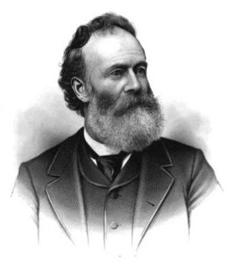
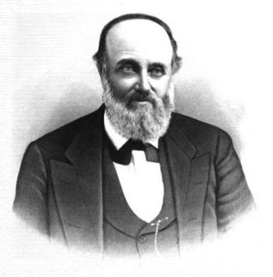
This street is named for Dr. Henry A. Smith (1830–1915), after whom Smith Cove is also named. He and his family once owned most of what is now Interbay, between Smith Cove and Salmon Bay. He is likely best known today for his translation of Chief Seattle’s Speech. Though its authenticity has been questioned, it is accepted by the Suquamish Tribe and Duwamish Tribe, both of which siʔaɫ was chief.
Dr. Henry A. Smith
Today, W Smith Street begins in Magnolia at the intersection of 37th Avenue W and 36th Avenue W and goes ⅘ of a mile east to just past 24th Avenue W, briefly becoming a stairway just west of 26th Avenue W at Ella Bailey Park. It begins again in Queen Anne at 7th Avenue W and goes ½ a mile east to Warren Avenue N, forming a portion of Queen Anne Boulevard between 1st Avenue W and Warren Avenue N. Smith Street’s final segment begins at 4th Avenue N and goes a block east, ending at a greenbelt overlooking Aurora Avenue N.
Born and raised in Seattle, Benjamin Donguk Lukoff had his interest in local history kindled at the age of six, when his father bought him settler granddaughter Sophie Frye Bass’s Pig-Tail Days in Old Seattle at the gift shop of the Museum of History and Industry. He studied English, Russian, and linguistics at the University of Washington, and went on to earn his master’s in English linguistics from University College London. His book of rephotography, Seattle Then and Now, was published in 2010. An updated version came out in 2015.
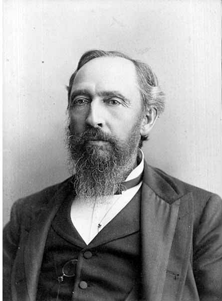
This street is named for Thomas Dickerson Mercer (1813–1898), who came to Seattle in 1853 and homesteaded 160 acres in what is now Lower Queen Anne, living at what is now Roy Street and Taylor Avenue N. He became a King County commissioner and probate judge, and named Lake Washington and Lake Union, whose Lushootseed names are x̌ačuʔ and xáx̌əʔčuʔ(‘lake’ and its diminutive, respectively). Mercer Island is named for him, as are three of its main streets, W Mercer Way, N Mercer Way, and E Mercer Way. Mercer Slough in Bellevue is named for his brother Aaron (1826-1902), and his brother Asa (1839–1917) is known for being the first instructor at, and first president of, the Territorial University of Washington (being the only college graduate in Seattle in 1861); and for bringing the “Mercer Girls” to Seattle to address the settlement’s severe gender imbalance (thereby inspiring the 1960s TV show Here Come the Brides).
Thomas Dickerson Mercer
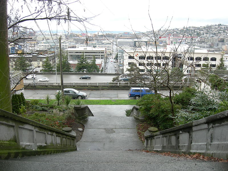
Today, W Mercer Street begins at Elliott Avenue W and goes a block east to 6th Avenue W, where it becomes a stairway. At the top of the stairway, the street becomes a major arterial (connecting directly to Elliott via W Mercer Place) and goes 1⅔ miles east to Eastlake Avenue E and Lakeview Boulevard E, where it is blocked by Interstate 5. (It is, incidentally, laid out on the boundary between the donation land claims of Mercer and David Thomas Denny. Mercer’s claim is today bounded by Queen Anne Avenue N on the west, Lake Union on the east, Highland Drive on the north, and Mercer Street on the south.) Connecting Interbay, Lower Queen Anne, Seattle Center, State Route 99, South Lake Union, Interstate 5, and Capitol Hill, Mercer Street is a linchpin of Seattle’s transportation system — but not a beloved one, having earned the name “Mercer Mess” decades ago.
East of Interstate 5, E Mercer Street begins again at Melrose Avenue E and goes nearly 1½ miles to 28th Avenue E, interrupted only once, at 17th Avenue E, where it is pedestrian-only for half a block. Mercer resumes briefly at Dewey Place E but after a couple hundred feet becomes a stairway connecting to Lake Washington Boulevard E and 31st Avenue E. A block east of that, at 32nd Avenue E, E Mercer Street resumes as another stairway, and becomes a street again just west of 33rd Avenue E. This segment goes about ⅛ of a mile to 36th Avenue E. There is one final 200-foot-long segment of E Mercer Street east of 39th Avenue E. Platted into Lake Washington, this is a shoreline street end, but not, unfortunately, one open to the public. (It was this particular street end that first got me involved with Friends of Street Ends, as I grew up just ¼ of a mile up the hill.)
Born and raised in Seattle, Benjamin Donguk Lukoff had his interest in local history kindled at the age of six, when his father bought him settler granddaughter Sophie Frye Bass’s Pig-Tail Days in Old Seattle at the gift shop of the Museum of History and Industry. He studied English, Russian, and linguistics at the University of Washington, and went on to earn his master’s in English linguistics from University College London. His book of rephotography, Seattle Then and Now, was published in 2010. An updated version came out in 2015.
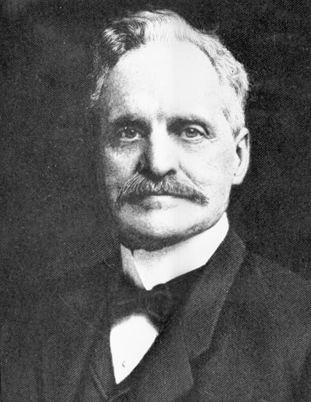
All in one year John McGraw was Chief of Police, Marshall, Sheriff, Harbor Master and Fire Warden. Later he was Governor of Washington and in between, bank president and attorney-at-law — quite a career.
The second governor of Washington after statehood (1893–1897), he had been King County sheriff during the anti-Chinese riots of 1886. He defended Chinese laborers from the mob that was trying to expel them from the city, although, according to The Role of Federal Military Forces in Domestic Disorders, 1877–1945, he initially sympathized with the rioters and allowed them to force the Chinese (without physically harming them) to the waterfront to be loaded onto the steamship Queen of the Pacific. Both he and Mayor Henry Yesler lost their bids for re-election that summer in what the book calls “a resounding show of support for anti-Chinese forces.”
John H. McGraw
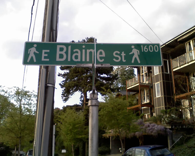
Today, W McGraw Street begins as a shoreline street end on Elliott Bay in Magnolia west of Perkins Lane W. It begins in earnest at the intersection of Westmont Way W, Montavista Place W, and Rosemont Place W and goes ⅘ of a mile east to 24th Avenue W, forming the heart of Magnolia Village, the neighborhood’s commercial district, from 35th Avenue W to 32nd Avenue W. It resumes on the other side of Interbay in Queen Anne, beginning at 11th Avenue W and going 1⅛ miles east to the Northeast Queen Anne Greenbelt east of Bigelow Avenue N. There are a few block-long segments heading down the hill to Westlake and, like Blaine Street, a right-of-way platted into Lake Union that serves as a driveway and affords no actual lake access.
E McGraw Street doesn’t appear again until 15th Avenue E and Boyer Avenue E in Montlake, where it goes ⅔ of a mile east to 26th Avenue E at the west end of the Washington Park Arboretum, becoming a stairway for a short distance just before 19th Avenue E. It ends for good in Madison Park as a two-block stretch between 38th Avenue E and 40th Avenue E.
Born and raised in Seattle, Benjamin Donguk Lukoff had his interest in local history kindled at the age of six, when his father bought him settler granddaughter Sophie Frye Bass’s Pig-Tail Days in Old Seattle at the gift shop of the Museum of History and Industry. He studied English, Russian, and linguistics at the University of Washington, and went on to earn his master’s in English linguistics from University College London. His book of rephotography, Seattle Then and Now, was published in 2010. An updated version came out in 2015.
Unfortunately, though the Blaines may have been feminists, they, according to HistoryLink.org, had no love for Native Americans (or, for that matter, the Irish). Their departure in 1856 was prompted by the Battle of Seattle. Junius Rochester writes:
On January 20, 1856, a son John, was born to Catharine and David Blaine. Six days later the Battle of Seattle erupted. David had duty at one of the blockhouses, but managed to get Catharine and their babe aboard the Decatur in Elliott Bay. David had described the Indians as a “poor degraded race,” which would “soon disappear.” Catharine compared their “stupidity and awkwardness” to that of the Irish. The Indian uprising confirmed their worst fears and prejudices.
Today, W Blaine Street begins in Magnolia at 36th Avenue W and goes a semicircular ⅕ of a mile to 34th Avenue W and W Howe Street. It resumes at 31st Avenue W and goes almost ⅓ of a mile to Thorndyke Avenue W. There is a stub of W Blaine east of 15th Avenue W that is quickly stopped by the Southwest Queen Anne Greenbelt. The street resumes at 12th Avenue W and goes just over a mile to 4th Avenue N, having briefly become a stairway at 9th Avenue W. After a series of short stretches serving as driveways and parking, the Blaine Street right-of-way resurfaces east of Westlake Avenue N and heads into Lake Union. Here, too, it serves as a driveway and offers no access to the water. East of Lake Union, E Blaine Street begins at Fairview Avenue E and goes ⅛ of a mile to Franklin Avenue E, where it becomes part of the I-5 Colonnade park underneath the freeway. From Lakeview Boulevard E to just west of 10th Avenue E it is a stairway, and then two blocks of roadway ending at 12th Avenue E and Lake View Cemetery. There is then a diagonal ¼-mile stretch from 19th Avenue E to E Howe Street in Montlake. E Blaine finishes up as a ⅕-mile stretch from 37th Avenue E to McGilvra Boulevard E and a final two-block run from E Madison Street to 43rd Avenue E, both in Madison Park.
Born and raised in Seattle, Benjamin Donguk Lukoff had his interest in local history kindled at the age of six, when his father bought him settler granddaughter Sophie Frye Bass’s Pig-Tail Days in Old Seattle at the gift shop of the Museum of History and Industry. He studied English, Russian, and linguistics at the University of Washington, and went on to earn his master’s in English linguistics from University College London. His book of rephotography, Seattle Then and Now, was published in 2010. An updated version came out in 2015.
Dillis Ward, when a young man, did his part in building the old University for he drove a team that hauled stone and lime for the foundation. After the building was finished, he entered as a pupil into the first class. He taught school later on, and many an old-timer can recall the genial, kindly school teacher.
According to this biography, Ward, who came to Seattle in 1859, also had a hand in founding both The Post (a predecessor of the Seattle Post-Intelligencer) and The Seattle Daily Chronicle (a predecessor of The Seattle Times). However, his name does not appear in Professor Edmond S. Meany’s Newspapers of Washington Territory, in this article on the Post Building from the Pacific Coast Architecture Database, or in this HistoryLink article on the history of the P-I. All of them do mention brothers Kirk C. and Mark Ward, but Dillis’s entry at FamilySearch mentions no siblings, and Mark and Kirk’s entries do not mention Dillis. However, they do appear to have the same father, Jesse Ward. It looks as if Dillis was Jesse’s son from his first marriage, to Elizabeth Raley. As she died the same year Dillis was born, it may have been in childbirth. Kirk and Mark appear to be Jesse’s sons from his subsequent marriage to Exeline Cason. Exactly what part he may have played in the founding of the papers, and why this is missing from the articles above (and, incidentally, from Pig-Tail Days, which one would think might have mentioned this fact) is unclear.
Ward Street begins at Queen Anne Avenue N and goes ⅗ of a mile east to Aurora Avenue N. There is a short segment of E Ward Street on Capitol Hill between 14th Avenue E and 15th Avenue E, followed by another one, ⅓ of a mile long, from 23rd Avenue E and Turner Way E down the hill to 29th Avenue E and E Aloha Street, at the west end of Washington Park Playfield. There follows another one-block segment on the other side of the park, between 31st Avenue E and 32nd Avenue E, and a final segment from 34th Avenue E to 37th Avenue E.
Born and raised in Seattle, Benjamin Donguk Lukoff had his interest in local history kindled at the age of six, when his father bought him settler granddaughter Sophie Frye Bass’s Pig-Tail Days in Old Seattle at the gift shop of the Museum of History and Industry. He studied English, Russian, and linguistics at the University of Washington, and went on to earn his master’s in English linguistics from University College London. His book of rephotography, Seattle Then and Now, was published in 2010. An updated version came out in 2015.
My good friend and former Amazon Music colleague Thomas May — a freelance arts and theatre writer and proprietor of Memeteria.com — was in Port Angeles, Washington, the other day. Knowing, of course, of my address nerdery, he sent me these photos he took of street signs at the corner of W Front Street and N Oak Street:
I was delighted and asked if I could use his photos on Writes of Way. He agreed, and this is the resulting post.
It seems that these Klallam-language signs were installed in 2016 at the N Oak Street/W Front Street and N Oak Street/W Railroad Avenue intersections as part of the redevelopment of the Port Angeles waterfront and as a way to honor the Lower Elwha Klallam Tribe, whose traditional land this is. (The village of č̕ixʷícən was located where downtown Port Angeles is now.) There are similar street signs on the Lower Elwha and Port Gamble S’Klallam reservations, but these are the only ones I am aware of in the middle of a city.
I would love to see something like this in Seattle, whether that be bilingual street signs or signs giving the Lushootseed names of various locations around town — or both. Perhaps someday.
Born and raised in Seattle, Benjamin Donguk Lukoff had his interest in local history kindled at the age of six, when his father bought him settler granddaughter Sophie Frye Bass’s Pig-Tail Days in Old Seattle at the gift shop of the Museum of History and Industry. He studied English, Russian, and linguistics at the University of Washington, and went on to earn his master’s in English linguistics from University College London. His book of rephotography, Seattle Then and Now, was published in 2010. An updated version came out in 2015.
This photograph is undated, but must have been taken before Rezin left the family around 1880. Margaret sued Rezin for divorce that year and he “fled to California,” not to return for many years.
Pontius Avenue N runs ⅓ of a mile from John Street north to just past Mercer Street, where it dead-ends at the Interstate 5–Mercer Street interchange (originally constructed in 1962–1963 as part of the planned Bay Freeway, which was cancelled 10 years later with little more progress having been made. Its original northern end was Roy Street.) Pontius originally began one block further south, at Denny Way, but this portion was vacated as part of the construction of the Denny Substation.*
* Or was it? The clerk file indicates the vacation was granted, but I can find no related ordinance, and the King County Parcel Viewer and quarter section map show the Pontius right-of-way still existing between Denny and John. Something for me to look into… sometime.
Born and raised in Seattle, Benjamin Donguk Lukoff had his interest in local history kindled at the age of six, when his father bought him settler granddaughter Sophie Frye Bass’s Pig-Tail Days in Old Seattle at the gift shop of the Museum of History and Industry. He studied English, Russian, and linguistics at the University of Washington, and went on to earn his master’s in English linguistics from University College London. His book of rephotography, Seattle Then and Now, was published in 2010. An updated version came out in 2015.
Today, W Republican Street begins a block west of 4th Avenue W and goes ⅖ of a mile east to Warren Avenue N, where it becomes Seattle Center’s pedestrian August Wilson Way. On the east side of Seattle Center, there is a one-block segment of Republican Street between 4th Avenue N and 5th Avenue N; the street then resumes at Dexter Avenue N at the northbound exit from the State Route 99 Tunnel. From there, it runs ⅔ of a mile east to Eastlake Avenue E, where it is blocked by Interstate 5. Resuming east of I-5 as a stairway at Melrose Avenue E, it becomes a street again after half a block and goes another 1⅕ miles from Bellevue Avenue E to 23rd Avenue E, interrupted only once at 17th Avenue E, which can only be crossed by pedestrians and bicycles. After a substantial gap, E Republican Street begins again at 29th Avenue E and E Arthur Place in Madison Valley, and goes ⅖ east to its end at Lake Washington Boulevard E.
(From 33rd Avenue E to Lake Washington Boulevard E, it forms the northern boundary of the Bush School campus; when I went there in the 1980s and 1990s, people from out of town thought I was joking when I told them I went to Bush School on Republican Street. The school, of course, wasn’t named for a member of the Bush political dynasty, but rather for its founder, Helen Taylor Bush.)
Born and raised in Seattle, Benjamin Donguk Lukoff had his interest in local history kindled at the age of six, when his father bought him settler granddaughter Sophie Frye Bass’s Pig-Tail Days in Old Seattle at the gift shop of the Museum of History and Industry. He studied English, Russian, and linguistics at the University of Washington, and went on to earn his master’s in English linguistics from University College London. His book of rephotography, Seattle Then and Now, was published in 2010. An updated version came out in 2015.
Born and raised in Seattle, Benjamin Donguk Lukoff had his interest in local history kindled at the age of six, when his father bought him settler granddaughter Sophie Frye Bass’s Pig-Tail Days in Old Seattle at the gift shop of the Museum of History and Industry. He studied English, Russian, and linguistics at the University of Washington, and went on to earn his master’s in English linguistics from University College London. His book of rephotography, Seattle Then and Now, was published in 2010. An updated version came out in 2015.
Like SW Bataan Street, Lanham Place SW is part of High Point, originally developed by the Seattle Housing Authority in 1942 as defense housing and redeveloped in 2004. The name was originally applied to SW Lanham Way, and was preserved while some other names, including SW Snow Court, Cycle Lane SW, and MacArthur Court SW, were eliminated. It was named for Fritz G. Lanham, Texas congressman, who sponsored the Lanham Act that created the Defense Homes Corporation.
Today, Lanham Place SW begins at 32nd Avenue SW and SW Raymond Street and goes ¼ mile southeast to 31st Avenue SW, Sylvan Way SW, and SW Morgan Street.
Born and raised in Seattle, Benjamin Donguk Lukoff had his interest in local history kindled at the age of six, when his father bought him settler granddaughter Sophie Frye Bass’s Pig-Tail Days in Old Seattle at the gift shop of the Museum of History and Industry. He studied English, Russian, and linguistics at the University of Washington, and went on to earn his master’s in English linguistics from University College London. His book of rephotography, Seattle Then and Now, was published in 2010. An updated version came out in 2015.
High Point, originally developed by the Seattle Housing Authority in 1942 as defense housing, was redeveloped in 2004. It was reconnected to the street grid, and as part of the process some street names, including SW Snow Court, Cycle Lane SW, MacArthur Court SW, and Bataan Place SW, were eliminated. (They are still visible in the city clerk’s geographic indexing atlas, which was created before the redevelopment and has not been updated.) No one appeared to care much about the loss of Snow, Cycle, or MacArthur (named for General Douglas MacArthur, who had recently evacuated to Australia when the fall of the Philippines seemed imminent).* The loss of Bataan, named for the World War II battle that took place on the Bataan Peninsula on the island of Luzon, was another story, however, and SW Eddy Street was quickly renamed SW Bataan Street, enabling the city to continue to “memorialize and honor the 10,000 American and Filipino soldiers who lost their lives in the Bataan death march.”
* See the August 7, 1943, Seattle Times article ‘City’s Wartime Additions Inspire Some Monickers’ for the story behind the street names in High Point, Rainier Vista, and other Seattle Housing Authority projects.
Born and raised in Seattle, Benjamin Donguk Lukoff had his interest in local history kindled at the age of six, when his father bought him settler granddaughter Sophie Frye Bass’s Pig-Tail Days in Old Seattle at the gift shop of the Museum of History and Industry. He studied English, Russian, and linguistics at the University of Washington, and went on to earn his master’s in English linguistics from University College London. His book of rephotography, Seattle Then and Now, was published in 2010. An updated version came out in 2015.
Because Squire was the first to apply the name to a street, I count E Remington Court as ultimately being named after his wife, Ida, though one could say Greene’s preservation of the name, after the E Jefferson Street name had been extended by ordinance in 1895 from First Hill to Lake Washington, might also have been to honor his mother, Catherine.
Watson Carvosso Squire and his wife, Ida Remington, circa 1910
Born and raised in Seattle, Benjamin Donguk Lukoff had his interest in local history kindled at the age of six, when his father bought him settler granddaughter Sophie Frye Bass’s Pig-Tail Days in Old Seattle at the gift shop of the Museum of History and Industry. He studied English, Russian, and linguistics at the University of Washington, and went on to earn his master’s in English linguistics from University College London. His book of rephotography, Seattle Then and Now, was published in 2010. An updated version came out in 2015.
This hook-shaped street on Beacon Hill begins where S Myrtle Street turns into Swift Avenue S, and goes just over 700 feet north, west, and then south to a point 300 feet to the northwest. It was created in 1967 as the only street in the plat of Covello Estates, filed by S.T. Covello, whose full name appears to be Salvatore Tony Covello (1913–1996). He was the son of Filippo and Josephine (Curreri) Covello, who came to the United States from Italy in 1908. An article in the September 25, 1946, Seattle Times mentions him as the owner of the Hillman City Radio and Electric Company, and one in the March 4, 1956, Times lists him as a candidate for the King County Board of Education.
Born and raised in Seattle, Benjamin Donguk Lukoff had his interest in local history kindled at the age of six, when his father bought him settler granddaughter Sophie Frye Bass’s Pig-Tail Days in Old Seattle at the gift shop of the Museum of History and Industry. He studied English, Russian, and linguistics at the University of Washington, and went on to earn his master’s in English linguistics from University College London. His book of rephotography, Seattle Then and Now, was published in 2010. An updated version came out in 2015.
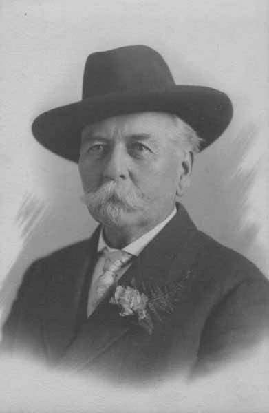
This street, which appears to have been established as part of the 1906 Replat of McGilvra’s Addition and Second Addition to the City of Seattle (an abbreviation of its much longer name), was named for John J. McGilvra (1827–1903). Born in Livingston County, New York, McGilvra moved to Illinois at the age of 17, and became a lawyer nine years later. In 1861, President Abraham Lincoln, who McGilvra reportedly knew as a fellow Illinois lawyer, appointed him United States Attorney for the Territory of Washington. In 1864, he moved to Seattle. That same year, he and his wife, Elizabeth, bought 420 acres of land in what is now Madison Park and became the area’s first settlers. McGilvra had Madison Street extended to the lakefront — it is still the only street to extend from Elliott Bay to Lake Washington without interruption — and later helped establish the Madison Street Cable Railway Company and Madison Park at its eastern terminus. In 1865 he relinquished the post of U.S. attorney. He was a member of the Territorial Legislature in 1866 and 1867, and Seattle city attorney in 1876 and 1877. He retired in 1890.
John J. McGilvra, circa 1890
Today, McGilvra Boulevard E begins in the south at 39th Avenue E and Lake Washington Boulevard E and goes 1⅖ miles north to E McGilvra Street. Unlike most other boulevards in the city, it is not an Olmsted boulevard — McGilvra was reportedly opposed to the movement that resulted in the hiring of the Olmsted Brothers in 1903 (the year of his death) to design a system of parks and boulevards for Seattle, though there is no evidence the two are directly related.
Born and raised in Seattle, Benjamin Donguk Lukoff had his interest in local history kindled at the age of six, when his father bought him settler granddaughter Sophie Frye Bass’s Pig-Tail Days in Old Seattle at the gift shop of the Museum of History and Industry. He studied English, Russian, and linguistics at the University of Washington, and went on to earn his master’s in English linguistics from University College London. His book of rephotography, Seattle Then and Now, was published in 2010. An updated version came out in 2015.
An ordinance accepting deeds from Hubert W. Youngs and Maude E. Youngs, husband and wife, Harry Richmond, William G. Knox, and Bessie S. Woodworth, for an easement for sewer over and across a portion of J. J. McGilvra’s 2nd Addition and Lake Washington Shore Lands.
Since Knox Place is very close to where the two plats meet, I figure it’s a good bet that William G. Knox has something to do with Knox Place. FamilySearch says a William Gifford Knox (1884–1964) lived in Seattle for a time, and even had a scan of his draft registration card for World War I, from September 12, 1918. He appears to have been a salesman for the Dennison Manufacturing Company downtown, and his address is given as 1836 Laurel Shade Avenue. That street is now 43rd Avenue E, putting his residence just a few blocks north of Knox Place E. So, although I don’t have the whole story, I think we now know who Knox Place is named for.
William Gifford Knox draft registration card for World War I, September 12, 1918
Born and raised in Seattle, Benjamin Donguk Lukoff had his interest in local history kindled at the age of six, when his father bought him settler granddaughter Sophie Frye Bass’s Pig-Tail Days in Old Seattle at the gift shop of the Museum of History and Industry. He studied English, Russian, and linguistics at the University of Washington, and went on to earn his master’s in English linguistics from University College London. His book of rephotography, Seattle Then and Now, was published in 2010. An updated version came out in 2015.


.jpg)