This street was created in 1925 as part of the plat of Ridgemont. Unnamed at the time, it was presumably later named after the subdivision. I say “presumably” because there is no record of its being named in Seattle’s online legislative database, which there should be if this was done after this part of town was annexed in 1953, and King County’s only goes back to 1969.
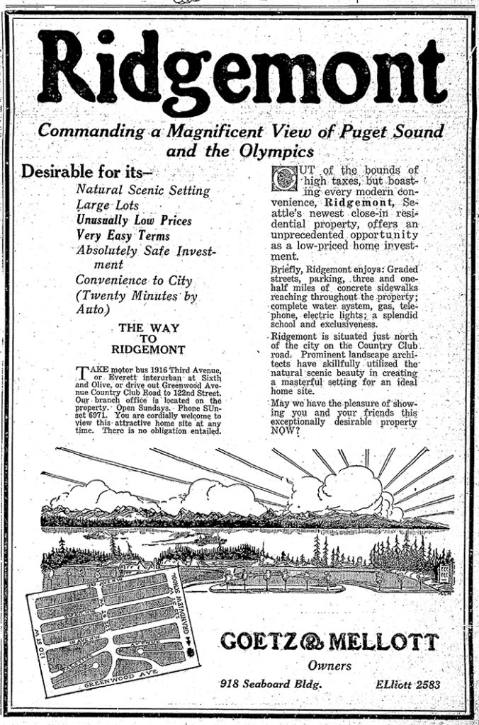
Ridgemont, as the below advertisement implies, was named for its location atop a ridge “commanding a magnificent view of Puget Sound and the Olympics.”
Ridgemont Way N begins at Greenwood Avenue N just south of N 125th Street and goes just over 425 feet southwest to N 122nd Street.
Advertisement for the Ridegmont subdivision, The Seattle Times, October 11, 1925. It would remain outside of the city and “out of the bounds of high taxes” for 28 years.
Born and raised in Seattle, Benjamin Donguk Lukoff had his interest in local history kindled at the age of six, when his father bought him settler granddaughter Sophie Frye Bass’s Pig-Tail Days in Old Seattle at the gift shop of the Museum of History and Industry. He studied English, Russian, and linguistics at the University of Washington, and went on to earn his master’s in English linguistics from University College London. His book of rephotography, Seattle Then and Now, was published in 2010. An updated version came out in 2015.
This street, like NW Culbertson Drive, was created in 1955 as part of the plat of Llandover-by-the-Sound, and was presumably named for the property’s view of the Olympic Mountains to the west. (I say property, singular, because there is only one house with an Alpine Way address).
Alpine Way NW begins at NW Culbertson Drive and goes just over 325 feet south to NW Northwood Road.
Born and raised in Seattle, Benjamin Donguk Lukoff had his interest in local history kindled at the age of six, when his father bought him settler granddaughter Sophie Frye Bass’s Pig-Tail Days in Old Seattle at the gift shop of the Museum of History and Industry. He studied English, Russian, and linguistics at the University of Washington, and went on to earn his master’s in English linguistics from University College London. His book of rephotography, Seattle Then and Now, was published in 2010. An updated version came out in 2015.
This street was named for Carkeek Park, which encompasses 216 acres in the Broadview neighborhood, including Pipers Creek and nearly ½ a mile of Puget Sound waterfront (though the usable beach is much shorter, as the main line of the BNSF Railway cuts off public access to the rest). It was one of the “46 new street names to simplify street addresses” The Seattle Times reported on in its issue November 6, 1960, and was made up of “Sixth Avenue Northwest from West 110th to West 111th Streets, West 111th Street from Sixth to Seventh Avenues Northwest, Seventh Avenue NW from West 111th to West 114th Streets, and West 114th Street from Seventh Avenue NW to West 116th Street.” (Part of this route was once Puget Drive, part of the 1911 View-Lands Addition.)
Morgan Carkeek, 1910Emily Carkeek, 1911
The park itself opened in 1929 and was named for Morgan James Carkeek (1847–1931) and his wife, Emily Gaskill Carkeek (1852–1926). According to the Museum of History & Industry, “Morgan… was an accomplished stonemason and successful building contractor who built several of Seattle’s early stone buildings, such as the Dexter Horton Bank, and large office buildings, including the Burke and Haller buildings.” In 1918, he and Emily donated land to the city for the first Carkeek Park, located along Lake Washington where Magnuson Park is today, but soon thereafter plans were made to develop Naval Air Station Seattle on the land, and the park was taken over by the Navy in 1926. The Carkeeks donated $25,000 to the city to purchase land elsewhere, and with the addition of $100,000 in public funds the city was able to buy Piper’s Canyon.
Report in The Seattle Times, May 28, 1927, on the Carkeeks’ contribution of funds to buy Piper’s Canyon. The Seattle Historical Society, which they had a hand in founding, never did build a museum in Carkeek Park, but ended up building the Museum of History & Industry in Montlake’s McCurdy Park instead. MOHAI opened in 1952 and moved to Lake Union Park in 2012 after having to make way for the expansion of Washington State Route 520.
NW Carkeek Park Road begins at NW 110th Street and Puget Drive NW and winds ½ a mile northwest to the entrance to Carkeek Park at NW 114th Street. Within the park, it goes a further ½ mile west, ending at a parking lot, picnic area, and playground. (This portion appears to have once been known as Piper’s Canyon Road or Pipers Road.) From here, there is a bridge over the BNSF Railway tracks to a beach along Puget Sound and the mouth of Pipers Creek.
Aerial view of Carkeek Park, looking southeast, July 9, 1969. The valley and outlet of Pipers Creek are clearly visible, as is the main line of the BNSF Railway that separates the park’s wooded and grassy areas from Puget Sound. Courtesy of the Seattle Municipal Archives, Identifier 77628.
Born and raised in Seattle, Benjamin Donguk Lukoff had his interest in local history kindled at the age of six, when his father bought him settler granddaughter Sophie Frye Bass’s Pig-Tail Days in Old Seattle at the gift shop of the Museum of History and Industry. He studied English, Russian, and linguistics at the University of Washington, and went on to earn his master’s in English linguistics from University College London. His book of rephotography, Seattle Then and Now, was published in 2010. An updated version came out in 2015.
This street was created in 1964 as part of the plat of Shoreline Park Estates. The subdivision was presumably named for Carkeek Park, which surrounds it on three sides and features a long Puget Sound shoreline.
Advertisement for Shoreline Park Estates, The Seattle Times, September 20, 1964. The address and phone number of Royal Homes Realty — 14802 Westminster Way N., Seattle 33, EMerson 4-5180 — would today be Shoreline, WA 98133, 206-364-5180, because of the incorporation of Shoreline in 1995; the mandatory use of ZIP Codes by bulk mailers, which began in 1967; the transition to all-number calling, which was completed in Greater Seattle in 1972; and the mandatory use of 10-digit dialing, which began in Greater Seattle in 2017.
Shoreline Park Drive NW runs about 275 feet between NW 118th Street and NW 117th Street. The developers dedicated a walkway west of NW 117th Street to the public; this connects to the Grand Fir Trail, one of Carkeek Park’s many trails.
Born and raised in Seattle, Benjamin Donguk Lukoff had his interest in local history kindled at the age of six, when his father bought him settler granddaughter Sophie Frye Bass’s Pig-Tail Days in Old Seattle at the gift shop of the Museum of History and Industry. He studied English, Russian, and linguistics at the University of Washington, and went on to earn his master’s in English linguistics from University College London. His book of rephotography, Seattle Then and Now, was published in 2010. An updated version came out in 2015.
Born and raised in Seattle, Benjamin Donguk Lukoff had his interest in local history kindled at the age of six, when his father bought him settler granddaughter Sophie Frye Bass’s Pig-Tail Days in Old Seattle at the gift shop of the Museum of History and Industry. He studied English, Russian, and linguistics at the University of Washington, and went on to earn his master’s in English linguistics from University College London. His book of rephotography, Seattle Then and Now, was published in 2010. An updated version came out in 2015.
Born and raised in Seattle, Benjamin Donguk Lukoff had his interest in local history kindled at the age of six, when his father bought him settler granddaughter Sophie Frye Bass’s Pig-Tail Days in Old Seattle at the gift shop of the Museum of History and Industry. He studied English, Russian, and linguistics at the University of Washington, and went on to earn his master’s in English linguistics from University College London. His book of rephotography, Seattle Then and Now, was published in 2010. An updated version came out in 2015.
Born and raised in Seattle, Benjamin Donguk Lukoff had his interest in local history kindled at the age of six, when his father bought him settler granddaughter Sophie Frye Bass’s Pig-Tail Days in Old Seattle at the gift shop of the Museum of History and Industry. He studied English, Russian, and linguistics at the University of Washington, and went on to earn his master’s in English linguistics from University College London. His book of rephotography, Seattle Then and Now, was published in 2010. An updated version came out in 2015.
This narrow street, which begins at 8th Avenue NW, snakes ⅔ of a mile west through a hilly, forested tract overlooking Puget Sound just north of Broadview Creek. It was established in 1940 as part of the Elford Park addition by Albert Sydney Elford (1867–1956) and his wife, Mae Caniff Elford (1877–1968), both originally from Ontario, Canada.
In Seattle and Environs, 1852–1924, by Cornelius Holgate Hanford, Albert S. Elford is described as “among the foremost representatives of insurance interests in the west,” having been transferred to Seattle in 1911 by the New York Life Insurance Company. He was also a director of the Dexter Horton National Bank; vice president, treasurer and a director of the Best Universal Lock Company; and a member of the First Methodist Episcopal Church, the Rainier Club, the Seattle Golf Club, the Rainier Golf and Country Club, the Elks, the Odd Fellows, and the Masons.
Unfortunately, Elford Park was among the far too many Seattle subdivisions that were created with racial restrictive covenants:
Tracts or parcels of land in this plat shall be used or occupied only by members of the white or Caucasian race, excluding Semites, and no other persons shall be permitted to use or occupy said tracts or parcels, except employees may occupy the premises where their employer resides.
Born and raised in Seattle, Benjamin Donguk Lukoff had his interest in local history kindled at the age of six, when his father bought him settler granddaughter Sophie Frye Bass’s Pig-Tail Days in Old Seattle at the gift shop of the Museum of History and Industry. He studied English, Russian, and linguistics at the University of Washington, and went on to earn his master’s in English linguistics from University College London. His book of rephotography, Seattle Then and Now, was published in 2010. An updated version came out in 2015.