As part of the Great Renaming of 1895, Texas Street, Town Street, Fontenelle Street, Flemming Street, Davidson Street, and Canal Street became Atlantic Street, from Elliott Bay to Lake Washington. The name was extended into West Seattle in 1907, when Grant Street and Louisiana Street were combined.
Today, SW Atlantic Street begins in West Seattle at Sunset Avenue SW and goes ¼ of a mile east to Palm Avenue SW. It next appears, as S Atlantic Street, just east of U.S. Coast Guard Base Seattle at Alaskan Way S, and goes around 800 feet east to 1st Avenue S, where it becomes Edgar Martinez Drive S (renamed in honor of the ball player in 2004). Apart from a stub east of Airport Way S that is soon blocked by Interstate 5, the street’s next appearance is on Beacon Hill, where it goes ⅓ of a mile from just west of 11th Avenue S to 17th Avenue S, the portion between 15th Avenue S and 16th Avenue S being a stairway.
After being interrupted for a number of blocks by Interstate 90, S Atlantic Street reappears at 21st Avenue S and goes a block to just east of 22nd Avenue S. (Here, it gives its name to the surrounding Atlantic neighborhood.) It resumes — again having been interrupted by Interstate 90’s Mount Baker Tunnel — at Bradner Place S and goes ⅓ of a mile east to Lake Washington Boulevard S, the portions between 30th Avenue S and 31st Avenue South as well as between 32nd Avenue S and 33rd Avenue S being stairways. The right-of-way begins again at 35th Avenue S and goes around ⅛ of a mile east to Lake Washington, but is either incorporated into adjacent homeowners’ yards or serves as their driveways for most of this distance. Between Lakeside Avenue S and the water, it is one of the city’s shoreline street ends.
Born and raised in Seattle, Benjamin Donguk Lukoff had his interest in local history kindled at the age of six, when his father bought him settler granddaughter Sophie Frye Bass’s Pig-Tail Days in Old Seattle at the gift shop of the Museum of History and Industry. He studied English, Russian, and linguistics at the University of Washington, and went on to earn his master’s in English linguistics from University College London. His book of rephotography, Seattle Then and Now, was published in 2010. An updated version came out in 2015.
SW Massachusetts Street begins in West Seattle at the intersection of Bonair Drive SW, 47th Avenue SW, and Sunset Avenue SW, and goes just under ⅓ of a mile east to Palm Avenue SW. It begins again at Ferry Avenue SW and goes just over 450 feet east to Victoria Avenue SW. There is a short segment (just over 400 feet) on Harbor Island east of 13th Avenue SW, and then another one, about the same length, leading from Alaskan Way S to the entrance to U.S. Coast Guard Base Seattle. (Here, the street’s directional designation has changed to S, it being east of the Duwamish Waterway.)
S Massachusetts Street resumes at Colorado Avenue S and goes ⅙ of a mile east to Occidental Avenue S. There is a block-long segment east of 4th Avenue S to just shy of the SODO Busway, and then a longer one — about ¼ of a mile — from the SODO Trail to Airport Avenue S.
East of Interstate 5, on Beacon Hill, S Massachusetts Street begins at 11th Avenue S and goes nearly ¼ of a mile east to just past 15th Avenue S, the portion between 14th Avenue S and 15th Avenue S being pedestrian-only, as the right-of-way between the sidewalks has been turned into the Beacon Bluff P-Patch community garden. It begins again just west of Sturgus Avenue S and goes nearly a mile east to just past 31st Avenue S, the portion that runs for half a block west of 17th Avenue S being a pathway. S Massachusetts Street resumes for the last time at 32nd Avenue S and goes ¼ mile east to Lake Washington, where it is a shoreline street end.
Born and raised in Seattle, Benjamin Donguk Lukoff had his interest in local history kindled at the age of six, when his father bought him settler granddaughter Sophie Frye Bass’s Pig-Tail Days in Old Seattle at the gift shop of the Museum of History and Industry. He studied English, Russian, and linguistics at the University of Washington, and went on to earn his master’s in English linguistics from University College London. His book of rephotography, Seattle Then and Now, was published in 2010. An updated version came out in 2015.
This street received its name in 1907, uniting streets formerly known as Nebraska Street, 8th Street, Bedford Street, Conover Street, and G Street. (There had been an Oregon Street in the 1895 Seattle Tide Lands plat in which Nebraska Street was created, but it became Spokane Street and Chelan Avenue in the same 1907 change.)
S Oregon Street begins in West Seattle as SW Oregon Street at the Emma Schmitz Memorial Overlook on Beach Drive SW and goes two blocks east to Me-Kwa-Mooks Park at 56th Avenue SW. It briefly resumes at 52nd Avenue SW and goes two blocks east to 51st Avenue SW, then begins again in earnest at 50th Avenue SW, going nearly a mile east to the West Seattle Stadium at 35th Avenue SW, part of the stretch between there and Fauntleroy Way SW being footpath and stairway. East of the West Seattle Golf Course, it goes around 175 feet to 26th Avenue SW and the Delridge Playfield, and on the other side of the playfield serves as a short connector between Delridge Way SW and 23rd Avenue SW.
S Oregon Street resumes east of the Duwamish Waterway at a shoreline street end and goes ¼ mile east to E Marginal Way S. It then serves as short connectors between Diagonal Avenue S and Denver Avenue S and between 7th Avenue S and Airport Way S.
East of Interstate 5, on Beacon Hill, S Oregon Street begins again at 10th Avenue S and goes ⅓ of a mile east to 15th Avenue S and S Columbian Way. It picks up again in the Rainier Valley at S Columbian Way and Martin Luther King Jr. Way S and goes ⅔ of a mile east to Genesee Park at 42nd Avenue S. East of the park, it resumes at 47th Avenue S and goes ¼ mile east to its end at 52nd Avenue S above the Lakewood Marina on Lake Washington.
Born and raised in Seattle, Benjamin Donguk Lukoff had his interest in local history kindled at the age of six, when his father bought him settler granddaughter Sophie Frye Bass’s Pig-Tail Days in Old Seattle at the gift shop of the Museum of History and Industry. He studied English, Russian, and linguistics at the University of Washington, and went on to earn his master’s in English linguistics from University College London. His book of rephotography, Seattle Then and Now, was published in 2010. An updated version came out in 2015.
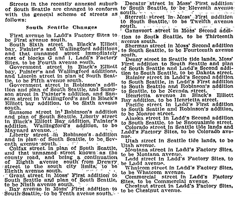
Article listing South Seattle street name changes in January 14, 1906, issue of the Seattle Post-Intelligencer
SW Nevada Street begins in West Seattle at 30th Avenue SW and goes ¼ mile east to 26th Avenue SW. It next appears east of the Duwamish Waterway in the Industrial District, as a ¼-mile-long service road off E Marginal Way S and a 300-foot-long dead-end road off 6th Avenue S. East of Interstate 5 on Beacon Hill, it goes ¼ mile east from 11th Avenue S to 16th Avenue S at Jefferson Park. It resumes for the last time in Rainier Valley at 28th Avenue S and S Adams Street and goes ¼ mile east to 31st Avenue S.
Born and raised in Seattle, Benjamin Donguk Lukoff had his interest in local history kindled at the age of six, when his father bought him settler granddaughter Sophie Frye Bass’s Pig-Tail Days in Old Seattle at the gift shop of the Museum of History and Industry. He studied English, Russian, and linguistics at the University of Washington, and went on to earn his master’s in English linguistics from University College London. His book of rephotography, Seattle Then and Now, was published in 2010. An updated version came out in 2015.
This is one of the many streets created as part of the 1895 Seattle Tide Lands plat that were named after U.S. states, including S Dakota Street, Utah Avenue S, and Colorado Avenue S. If I am correct, though, it is by far the shortest, as S Idaho Street begins just east of the Duwamish Waterway and goes just ¼ mile east to E Marginal Way S.
Born and raised in Seattle, Benjamin Donguk Lukoff had his interest in local history kindled at the age of six, when his father bought him settler granddaughter Sophie Frye Bass’s Pig-Tail Days in Old Seattle at the gift shop of the Museum of History and Industry. He studied English, Russian, and linguistics at the University of Washington, and went on to earn his master’s in English linguistics from University College London. His book of rephotography, Seattle Then and Now, was published in 2010. An updated version came out in 2015.
Streets in this plat that were not extensions of already existing ones, such as Commercial Street, were named after letters of the alphabet, American cities, American states, prominent local politicians, and places in Washington.… the states appear neither in alphabetical nor geographic order.
In this case, of course, the street was named for the Dakotas, not for South Dakota.
SW Dakota Street begins at 56th Avenue SW and goes 1⅓ miles east to 34th Avenue SW. It resumes at 30th Avenue SW and goes a further ⅓ of a mile east to Delridge Way SW, the portion between 28th Avenue SW and 26th Avenue SW being footpaths through the Longfellow Creek Natural Area park. SW Dakota Street begins again just west of 21st Avenue SW and goes just over 750 feet east to 19th Avenue SW, and there is one final segment west of the Duwamish Waterway between 16th Avenue SW and W Marginal Way SW.
East of the Duwamish, S Dakota Street runs for a block between 1st Avenue S and 2nd Avenue S, then picks up again at 6th Avenue S and goes ¼ mile east to 9th Avenue S. East of Interstate 5 on Beacon Hill, S Dakota Street resumes at 12th Avenue S and goes another ¼ mile east to Jefferson Park at 16th Avenue S. It begins again in the Rainier Valley at 29th Avenue S and goes ⅓ of a mile east to 34th Avenue S, picking up again at Rainier Avenue S and going ⅖ of a mile east to Genesee Park at 43rd Avenue S. On the other side of the park, it resumes at 46th Avenue S and goes ⅓ of a mile east to its end at 51st Avenue S, overlooking Lake Washington.
Born and raised in Seattle, Benjamin Donguk Lukoff had his interest in local history kindled at the age of six, when his father bought him settler granddaughter Sophie Frye Bass’s Pig-Tail Days in Old Seattle at the gift shop of the Museum of History and Industry. He studied English, Russian, and linguistics at the University of Washington, and went on to earn his master’s in English linguistics from University College London. His book of rephotography, Seattle Then and Now, was published in 2010. An updated version came out in 2015.
Streets in this plat that were not extensions of already existing ones, such as Commercial Street, were named after letters of the alphabet, American cities, American states, prominent local politicians, and places in Washington.… the states appear neither in alphabetical nor geographic order.
SW Florida Street begins on Harbor Island at 11th Avenue SW and goes ¼ mile southwest to 16th Avenue SW. The right-of-way continues for another ⅖ of a mile through Terminal 5 in West Seattle, though only a small portion (beginning at Harbor Avenue SW and going about 700 feet northeast) corresponds with an actual roadway.
Born and raised in Seattle, Benjamin Donguk Lukoff had his interest in local history kindled at the age of six, when his father bought him settler granddaughter Sophie Frye Bass’s Pig-Tail Days in Old Seattle at the gift shop of the Museum of History and Industry. He studied English, Russian, and linguistics at the University of Washington, and went on to earn his master’s in English linguistics from University College London. His book of rephotography, Seattle Then and Now, was published in 2010. An updated version came out in 2015.
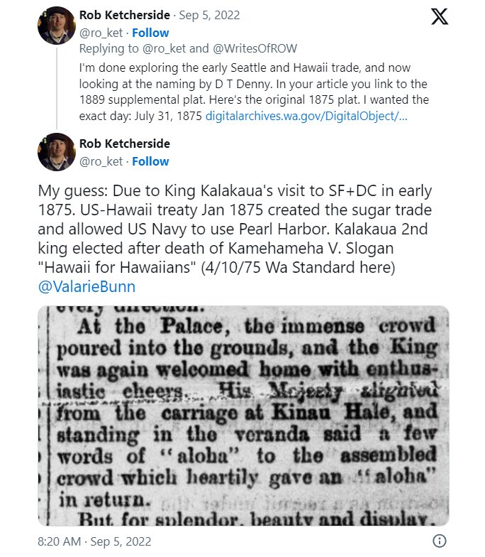
I haven’t posted in two weeks because I recently had the good fortune to visit, and the sad duty to return from, Maui, “the Valley Isle,” second largest of the Hawaiian Islands. That made me think, as I posted about S Spokane Street after traveling there last December, it would be appropriate to post about Aloha Street today.
Four and a half years ago, local historian Valarie Bunn wrote a post on her Wedgwood in Seattle History blog called “Searching for the Origin of Seattle Street Names.” It begins “There is no resource list of the meanings of Seattle’s street names or how the street names were derived,” and that was certainly true at the time. (One reason I started Writes of Way the next year was to eventually provide such a list — and now I rate a mention at the end of her article!) She continues:
Some street names are apparent in their derivation when honoring an early settler, such as Denny Way for the original homestead claim property of David Denny (Arthur’s younger brother) and Mercer Street for Thomas Mercer, an early, influential settler of Seattle. But for some other street names, such as Aloha Street, we may feel bewildered as we wonder, what is “Aloha” for?
She goes on to give a tutorial in trying to determine street name origins. She first notes that the street name was extended beyond Lower Queen Anne as part of the Great Renaming of 1895, and that its first appearance was as part of the 1875 plat of D.T. Denny’s Second Addition to North Seattle (as this part of South Lake Union then was). David Thomas Denny (1832–1903) and Louisa Boren Denny (1827–1916) were members of the Denny Party, who landed at Alki Point in 1851 and are considered the founders of modern Seattle. Here, though, the trail ends, as
The Dennys’ plat map of 1875 does not tell us why David and Louisa Denny chose the street names that they did, including “Aloha.”
But, she continues,
From earliest days, the Dennys knew that lumber was being shipped out from Seattle to San Francisco and as far as Hawaii, so our best guess is that they chose the word “Aloha” as a reference to Seattle’s trade connections.
Not as definitive an answer as the one she goes on to give for Cleopatra Place NW, but a pretty good one nevertheless, and one I can’t improve upon.
Note: On September 5, my friend, local historian Rob Ketcherside, did a bit of a dive into the matter. He began thus —
— and came to this conclusion:
I had come across the Reciprocity Treaty when trying to find any connection between Seattle and Hawaii in 1875,but…
So there, for now, the matter lies.
Note added August 13, 2023: The devastating Lāhainā wildfiremade me want to re-read this article, and I realized I neglected to discuss the route Aloha Street takes through Seattle. It begins at 1st Avenue W as W Aloha Street, and becomes Aloha Street a block to the east as it crosses Queen Anne Avenue N. From there, it goes ¾ of a mile east to Westlake Avenue N, where it is interrupted by Lake Union. It resumes at Fairview Avenue N and goes ⅙ of a mile east through the Fred Hutch Cancer Center campus to Eastlake Avenue E. On the other side of Interstate 5, it picks up again at Boylston Avenue E and goes an uninterrupted 1⅓ mileseast to its end at the intersection of 29th Avenue E and E Ward Street at the west end of the Washington Park Playfield.
Note: On August 20, 2024, I finished converting embedded tweets on this website to screenshots because of issues with how they were integrating with WordPress, which began not too long after Elon Musk purchased Twitter and changed its name to X.
Born and raised in Seattle, Benjamin Donguk Lukoff had his interest in local history kindled at the age of six, when his father bought him settler granddaughter Sophie Frye Bass’s Pig-Tail Days in Old Seattle at the gift shop of the Museum of History and Industry. He studied English, Russian, and linguistics at the University of Washington, and went on to earn his master’s in English linguistics from University College London. His book of rephotography, Seattle Then and Now, was published in 2010. An updated version came out in 2015.
S Fidalgo Street begins at a shoreline street end on the Duwamish Waterway just west of Ohio Avenue S and goes 700 feet east to E Marginal Way S. It picks up again at 1st Avenue S and goes half a mile east, then southeast, to a dead end just east of Padilla Place S.
Born and raised in Seattle, Benjamin Donguk Lukoff had his interest in local history kindled at the age of six, when his father bought him settler granddaughter Sophie Frye Bass’s Pig-Tail Days in Old Seattle at the gift shop of the Museum of History and Industry. He studied English, Russian, and linguistics at the University of Washington, and went on to earn his master’s in English linguistics from University College London. His book of rephotography, Seattle Then and Now, was published in 2010. An updated version came out in 2015.
S Orcas Street begins at E Marginal Way S and goes ¾ of a mile east, then southeast, to Corson Avenue S, where it becomes S Doris Street. It picks up again east of Interstate 5 at 15th Avenue S and goes three blocks east to 18th Avenue S. Its longest and final stretch begins just west of 20th Avenue S and goes 2¼ miles east to Lake Washington Boulevard S just west of Seward Park.
Born and raised in Seattle, Benjamin Donguk Lukoff had his interest in local history kindled at the age of six, when his father bought him settler granddaughter Sophie Frye Bass’s Pig-Tail Days in Old Seattle at the gift shop of the Museum of History and Industry. He studied English, Russian, and linguistics at the University of Washington, and went on to earn his master’s in English linguistics from University College London. His book of rephotography, Seattle Then and Now, was published in 2010. An updated version came out in 2015.
Born and raised in Seattle, Benjamin Donguk Lukoff had his interest in local history kindled at the age of six, when his father bought him settler granddaughter Sophie Frye Bass’s Pig-Tail Days in Old Seattle at the gift shop of the Museum of History and Industry. He studied English, Russian, and linguistics at the University of Washington, and went on to earn his master’s in English linguistics from University College London. His book of rephotography, Seattle Then and Now, was published in 2010. An updated version came out in 2015.
This street was created in 1905 as part of the Steel Works Addition to West Seattle by Albert C. Phillips. Originally Cityview Street, it formed a trio with Grandview Street and Bayview Street, which are today SW Hinds Street and SW Spokane Street, and was named for its view of Seattle, to the northwest across Elliott Bay.
SW City View Street begins at 35th Avenue SW as a driveway and foot path which becomes a paved street just before 34th Avenue SW and extends just beyond, about 325 feet in all. The right-of-way continues through a greenbelt, and the road picks up at again at SW Admiral Way, where it goes 500 feet east to end at 30th Avenue SW.
Born and raised in Seattle, Benjamin Donguk Lukoff had his interest in local history kindled at the age of six, when his father bought him settler granddaughter Sophie Frye Bass’s Pig-Tail Days in Old Seattle at the gift shop of the Museum of History and Industry. He studied English, Russian, and linguistics at the University of Washington, and went on to earn his master’s in English linguistics from University College London. His book of rephotography, Seattle Then and Now, was published in 2010. An updated version came out in 2015.
I haven’t posted in a couple of weeks because I’ve been in Spokane, visiting my wife’s family for the holidays and attending the memorial service of my sister-in-law, may her memory be for a blessing. Since there is no Emily Street in Seattle, why not return, then, with a post on Spokane Street?
S Spokane Street looking west from 1st Avenue South, July 5, 2013. Photograph by Flickr user Curtis Cronn, licensed under Creative Commons Attribution-NonCommercial-NoDerivs 2.0 Generic. The barcodes on the support columns for the Spokane Street Viaduct was, in the words of the artwork’s creators, Claudia Reisenberger and Franka Diehnelt, intended “to ‘label’ the many layers that constitute SoDo’s history”; the word visible at upper left, ‘slóóweehL’, is a Lushootseed-language word that, according to Coll Thrush, author of Native Seattle: Histories from the Crossing-Over Place, “refers to channels, or ‘canoe-passes’, in the grassy marsh through which canoes can be pushed to effect a shortcut,” and was a Duwamish place name referring to what is now approximately 4th Avenue S and S Spokane Street. (Incidentally, this is the same word rendered as sluʔwiɫ in the IPA-based Lushootseed alphabet, which was also used as a name for what is now University Village, and is now the official name of a street on the University of Washington campus.)
Spokane Street appears to have been created in 1895 as part of the Seattle Tide Lands plat. Streets in this plat that were not extensions of already existing ones, such as Commercial Street, were named after letters of the alphabet, American cities, American states, prominent local politicians, and places in Washington. The letters of the alphabet and the American cities appear in alphabetical order, but the states appear neither in alphabetical nor geographic order, and the places in Washington do not appear to be in any order whatsoever (except that a number beginning with Q are physically clustered together). They are as follows, listed alphabetically:
(I leave out West Point Avenue [which still exists, but only as a paper street] and Seattle Boulevard [now Airport Way S and Diagonal Avenue S] because the former was named for its proximity to West Point and the latter, it seems, for its prominence.)
It isn’t a list entirely composed of cities, islands, peninsulas, lakes, or rivers… the only things I notice are ⅔ of them are in Western Washington, with Chelan, Klickitat, and Wenatchee being in Central Washington and Spokane being in Eastern Washington; plus half the Western Washington locations (those beginning with Q) are on the Olympic Peninsula. It seems what is today Spokane Street could just as easily have been something else, and what is today such a prominent street wasn’t purposefully named after what was then the state’s third largest city (today, it ranks second).
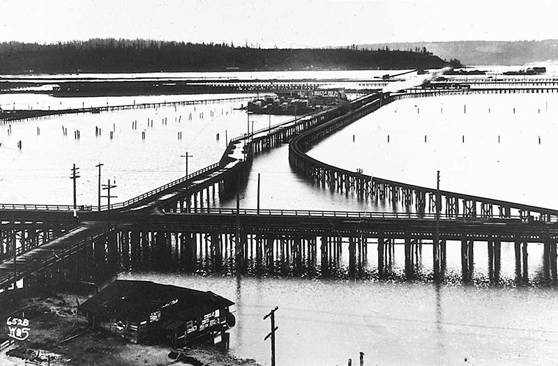
Trestles over the Elliott Bay tideflats, 1905. Photograph by Ira Webster and Nelson Stevens. According to the Wikimedia Commons entry for a similar photograph, the trestle in the foreground, running right to left (north to south), is today’s Airport Way S; the parallel trestle in the distance is 4th Avenue S; and running perpendicular from lower left to upper right (east to west, toward West Seattle) is S Spokane Street. The Seattle Box Company plant is visible at 4th and Spokane.
A modern view of the Industrial District, Harbor Island, and West Seattle from above Beacon Hill, August 15, 2010. Photograph by Flickr user J Brew, licensed under Creative Commons Attribution-ShareAlike 2.0 Generic. The freeway in the foreground, running right to left (north to south), is Interstate 5. Airport Way S is visible just west of the freeway. The Spokane Street Viaduct and West Seattle Bridge can be seen at left heading from Beacon Hill to West Seattle. 4th Avenue S is still a major arterial, though it isn’t nearly as prominent in this photograph as the one taken 105 years earlier.
Today, SW Spokane Street begins in West Seattle at Beach Drive SW, ½ a mile southeast of Alki Point, then goes nearly ½ a mile east to Schmitz Park, the block between 61st Avenue SW and 60th Avenue SW being a stairway. It resumes on the other side of the park at 51st Avenue SW and goes another ½ mile to 42nd Avenue SW. After a few interrupted segments between 35th Avenue SW and 30th Avenue SW, including another stairway, it begins again in earnest at Harbor Avenue SW and SW Admiral Way. From here it goes a full 2¼ miles east to Airport Way S, crossing the Duwamish Waterway and Harbor Island on the Spokane Street Bridge, and for this entire length runs either underneath or in the shadow of the West Seattle Bridge or the Spokane Street Viaduct, the latter of which leads to S Columbian Way on Beacon Hill.
After a short segment between Hahn Place S and 13th Avenue S, S Spokane Street begins again at 14th Avenue S and S Columbian Way and goes ⅔ of a mile east to 24th Avenue S. With the exception of an even shorter segment hanging off 25th Avenue S north of the Cheasty Boulevard greenspace, it next appears in Mount Baker, where it runs for two blocks between 33rd Avenue S and 35th Avenue S (part of this being stairway); then two more blocks between 36th Avenue S and York Road S (featuring another stairway); and two final blocks between 37th Avenue S and Bella Vista Avenue S.
Portion of 1895 plat of Seattle Tide Lands showing Spokane Avenue, now Spokane Street. The visible portion of Seattle Boulevard is now Diagonal Avenue S, and Whatcom Avenue is E Marginal Way S. Portions of Chelan Avenue, Klickitat Avenue, and Duwamish Avenue still exist, as do Oregon Street, Dakota Street, Idaho Street, Colorado Avenue, and Utah Avenue.
Born and raised in Seattle, Benjamin Donguk Lukoff had his interest in local history kindled at the age of six, when his father bought him settler granddaughter Sophie Frye Bass’s Pig-Tail Days in Old Seattle at the gift shop of the Museum of History and Industry. He studied English, Russian, and linguistics at the University of Washington, and went on to earn his master’s in English linguistics from University College London. His book of rephotography, Seattle Then and Now, was published in 2010. An updated version came out in 2015.
Born and raised in Seattle, Benjamin Donguk Lukoff had his interest in local history kindled at the age of six, when his father bought him settler granddaughter Sophie Frye Bass’s Pig-Tail Days in Old Seattle at the gift shop of the Museum of History and Industry. He studied English, Russian, and linguistics at the University of Washington, and went on to earn his master’s in English linguistics from University College London. His book of rephotography, Seattle Then and Now, was published in 2010. An updated version came out in 2015.
Born and raised in Seattle, Benjamin Donguk Lukoff had his interest in local history kindled at the age of six, when his father bought him settler granddaughter Sophie Frye Bass’s Pig-Tail Days in Old Seattle at the gift shop of the Museum of History and Industry. He studied English, Russian, and linguistics at the University of Washington, and went on to earn his master’s in English linguistics from University College London. His book of rephotography, Seattle Then and Now, was published in 2010. An updated version came out in 2015.
In 1906, Harrison Avenue became Pacific Place and Railroad Avenue became Brintnall Place. (Why the opportunity wasn’t taken to match the names is unclear. Brintnall Place may have been named for Burgess W. Brintnall, who, according to the September 1912 issue of the Northwest Journal of Education, had been school superintendent for Olympia and Thurston County, founded the journal itself, and, after moving to Seattle in 1899, founded the Pacific Teachers Agency. He was murdered on July 3, 1912.)
At some point both streets became Pacific Street. Brintnall Place appears for the last time in The Seattle Times in October 1920, and Pacific Street for the first time in July 1921. The 1920 Kroll atlas shows all three names, including Pacific Place, indicating the change must have been planned at the time of its publication.
I haven’t seen any indication of why the Pacific name was chosen. Seattle got an Atlantic Street in 1895 — maybe it was thought the other major ocean deserved a street as well. But I wonder if it wasn’t named for the Northern Pacific, whose tracks the street ran along?
Today, NE Pacific Street begins at Montlake Boulevard NE, at the north end of the Montlake Bridge and the southeastern corner of the University of Washington campus, and goes ¾ of a mile to Eastlake Place NE, underneath the University Bridge, where it becomes NE Northlake Way. It begins again at NE 40th Street just west of the Ship Canal Bridge and goes another ¾ of a mile to N 34th Street just east of Meridian Avenue N.
Pacific Street’s current configuration is the result of a realignment that took place in the 1970s; originally, instead of turning west at University Way NE, it kept going northwest, cutting through what is now the University of Washington’s West Campus, and there was no interruption between the University and Ship Canal Bridges. The Burke–Gilman Trail follows the original railroad alignment, though, as does, for a few blocks, the campus road Cowlitz Road NE.
Born and raised in Seattle, Benjamin Donguk Lukoff had his interest in local history kindled at the age of six, when his father bought him settler granddaughter Sophie Frye Bass’s Pig-Tail Days in Old Seattle at the gift shop of the Museum of History and Industry. He studied English, Russian, and linguistics at the University of Washington, and went on to earn his master’s in English linguistics from University College London. His book of rephotography, Seattle Then and Now, was published in 2010. An updated version came out in 2015.
This street appears to have been built sometime between 1908 and 1912. (It was established by ordinance in 1906, but that was legislation, not construction. [It was also originally named Ewing Street, the original name of N 34th Street, which still exists on the Queen Anne side of the Ship Canal.]) When the plat of Denny & Hoyt’s Addition to the City of Seattle, W.T., was filed in 1888, no such street was needed, because there was no canal. Instead, Ross Creek connected Lake Union to Salmon Bay. However, as work on the Lake Washington Ship Canal progressed, the Fremont Cut came into being, and it must have been felt a street paralleling the canal to the north was needed, since the original plat took no notice of the creek or any future canal route. (One to the south was needed, too, which is why Nickerson Street was extended from 3rd Avenue W to 4th Avenue N, at the southern end of the Fremont Bridge.)
Why, then, is Canal Street so short — not quite ⅓ of a mile from N 34th Street and Phinney Avenue N in the east to 2nd Avenue NW in the west?
As it turns out, even though Canal Street was to run to what was then the boundary between the cities of Seattle and Ballard at 8th Avenue NW, shortly after Seattle annexed Ballard in 1907 another street was laid out parallel to the canal connecting Fremont to the new neighborhood of Ballard: Leary Way NW (then simply Leary Avenue, all the way from Market Street to Fremont Avenue). Leary became the main arterial, and in 1951 NW Canal Street was vacated between 3rd Avenue NW and 8th Avenue NW, reducing it to its present length. (Until 2016, there was a slight discontinuity in the vicinity of 1st Avenue NW and N 35th Street where the built street deviated from its right-of-way, making it even shorter.)
So this isn’t quite the same as our trio of S Front Street, S River Street, and S Riverside Drive literally being cut short by the rechanneling of the Duwamish River into the Duwamish Waterway — more one of Canal Street being supplanted by Leary Way and becoming more valuable to the city as industrial land than as roadway.
Born and raised in Seattle, Benjamin Donguk Lukoff had his interest in local history kindled at the age of six, when his father bought him settler granddaughter Sophie Frye Bass’s Pig-Tail Days in Old Seattle at the gift shop of the Museum of History and Industry. He studied English, Russian, and linguistics at the University of Washington, and went on to earn his master’s in English linguistics from University College London. His book of rephotography, Seattle Then and Now, was published in 2010. An updated version came out in 2015.
Portion of River Park addition showing Southern Avenue (now Southern Street)
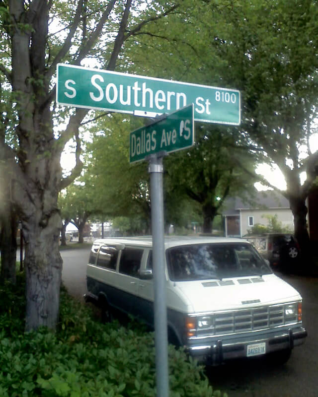
S Southern Street begins just east of 12th Avenue S on the west bank of the Duwamish Waterway, and goes ½ a mile to just west of 7th Avenue S, where it is blocked by Washington State Route 99 (W Marginal Way S). (Its first tenth of a mile is within unincorporated King County as part of the “Sliver by the River.”) It begins again in West Seattle as SW Southern Street at 35th Avenue SW, and goes ⅗ of a mile to 44th Avenue SW.
Born and raised in Seattle, Benjamin Donguk Lukoff had his interest in local history kindled at the age of six, when his father bought him settler granddaughter Sophie Frye Bass’s Pig-Tail Days in Old Seattle at the gift shop of the Museum of History and Industry. He studied English, Russian, and linguistics at the University of Washington, and went on to earn his master’s in English linguistics from University College London. His book of rephotography, Seattle Then and Now, was published in 2010. An updated version came out in 2015.
Martin Van Buren Stacy, from his obituary in the April 18, 1901, Seattle Post-Intelligencer. He had died at Green River Hot Springs the previous week of “apoplexy.”
S Stacy Street begins at Airport Way S and goes ⅕ of a mile west to 6th Avenue S. There is a block-long segment between 4th Avenue S and 3rd Avenue S, and then on the other side of the former Stacy Yard a two-block–long segment from Occidental Avenue S to Utah Avenue S and the world headquarters of Starbucks.
Born and raised in Seattle, Benjamin Donguk Lukoff had his interest in local history kindled at the age of six, when his father bought him settler granddaughter Sophie Frye Bass’s Pig-Tail Days in Old Seattle at the gift shop of the Museum of History and Industry. He studied English, Russian, and linguistics at the University of Washington, and went on to earn his master’s in English linguistics from University College London. His book of rephotography, Seattle Then and Now, was published in 2010. An updated version came out in 2015.
This street was named for Walter Graham (1828–1919), who came to Seattle in 1853. Three years later, he married Eliza Mercer, second daughter of Thomas Mercer (Mercer Street, Mercer Island), though she unfortunately died six years later. With his third wife, Elizabeth Crammond (or Crommon), he had a daughter, Nellie, who later married David Thomas Denny II, son of early settler David Thomas Denny (Denny Way). Graham’s brother, David, came to Seattle four years after his brother, and was one of the city’s first schoolteachers. He ended up marrying Eliza Mercer’s sister, Susannah.
Graham sold some of his southeast Seattle land in 1865 to Everett Smith, who filed the plat of Brighton Beach in 1890 on which what was then Graham Avenue appeared. He once owned what is today Seward Park on Bailey Peninsula, which was previously known as Graham’s Peninsula.
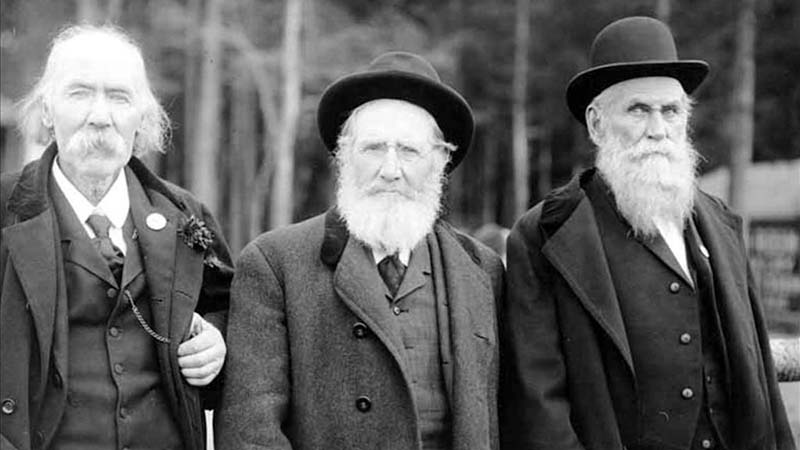
He was present at the Battle of Seattle in 1856, and is pictured below with fellow survivors Ira Woodin and Carson D. Boren (Boren Avenue).
Ira Woodin, Carson Boren, and Walter Graham at Alki Point, November 3, 1905
S Graham Street begins in the east at Wilson Avenue S and goes 2⅒ miles west to Swift Avenue S and 20th Avenue S, just east of Interstate 5. After a short segment between Corgiat Drive S and 16th Avenue S just west of the freeway, it next appears in West Seattle. Betwen 16th Avenue SW and 22nd Avenue SW, it alternates between roadway, stairway, and pathway, and there is a similar situation between 25th Avenue SW at Delridge Way SW and High Point Drive SW at Bataan Park. SW Graham Street begins again at High Point Drive SW and SW Raymond Street and goes 1¼ miles to its end at 50th Avenue SW,
Born and raised in Seattle, Benjamin Donguk Lukoff had his interest in local history kindled at the age of six, when his father bought him settler granddaughter Sophie Frye Bass’s Pig-Tail Days in Old Seattle at the gift shop of the Museum of History and Industry. He studied English, Russian, and linguistics at the University of Washington, and went on to earn his master’s in English linguistics from University College London. His book of rephotography, Seattle Then and Now, was published in 2010. An updated version came out in 2015.


.jpg)