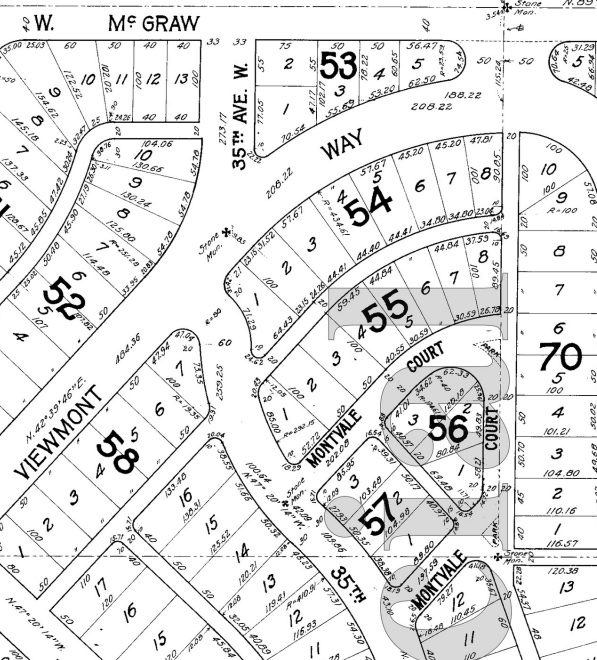
What is now Montvale Place W was originally Montvale Court W, created in 1915 as part of the plat of Carleton Park. When originally platted, Montvale Court formed a horseshoe-shaped loop, but at some point (the quarter section map doesn’t say, and I can find no relevant city ordinance), the eastern and southeastern part of the street, plus the alley connecting to 34th Avenue W, was renamed Montvale Place W.
Montvale Place W begins at 35th Avenue W south of Montvale Court W and goes ⅛ of a mile northeast, then north, to the intersection of Viewmont Way W, 34th Avenue W, and W Lynn Street.
Portion of plat of Carleton Park showing original course of Montvale Court W, over half of which is now Montvale Place W
Born and raised in Seattle, Benjamin Donguk Lukoff had his interest in local history kindled at the age of six, when his father bought him settler granddaughter Sophie Frye Bass’s Pig-Tail Days in Old Seattle at the gift shop of the Museum of History and Industry. He studied English, Russian, and linguistics at the University of Washington, and went on to earn his master’s in English linguistics from University College London. His book of rephotography, Seattle Then and Now, was published in 2010. An updated version came out in 2015.
This street was created in 1988 as part of the development of Chandler’s Cove, now being redeveloped as Lake Union Piers. Beginning at Fairview Avenue N between Valley Street and Aloha Street and going just over 125 feet north to Waterway 5 on Lake Union, it was presumably named after the avenue.
Born and raised in Seattle, Benjamin Donguk Lukoff had his interest in local history kindled at the age of six, when his father bought him settler granddaughter Sophie Frye Bass’s Pig-Tail Days in Old Seattle at the gift shop of the Museum of History and Industry. He studied English, Russian, and linguistics at the University of Washington, and went on to earn his master’s in English linguistics from University College London. His book of rephotography, Seattle Then and Now, was published in 2010. An updated version came out in 2015.
This private street begins at 2nd Avenue S and S King Street and goes 300 feet south to the north parking lot of Lumen Field. It was created in 2011 as part of the Stadium Place development, after which it was named. The development, in turn, was so named for its proximity to Lumen Field, known as Seahawks Stadium from 2002 to 2004, Qwest Field from 2004 to 2011, and CenturyLink Field from 2011 to 2020.
Born and raised in Seattle, Benjamin Donguk Lukoff had his interest in local history kindled at the age of six, when his father bought him settler granddaughter Sophie Frye Bass’s Pig-Tail Days in Old Seattle at the gift shop of the Museum of History and Industry. He studied English, Russian, and linguistics at the University of Washington, and went on to earn his master’s in English linguistics from University College London. His book of rephotography, Seattle Then and Now, was published in 2010. An updated version came out in 2015.
This street was created in 1966 as Union Place, a state-owned frontage road for the recently constructed Interstate 5. (Construction of an earlier, nearby Union Place had been approved and then repealed in 1902.) It was renamed Convention Place in 1988 when the city took ownership as part of the construction of the Washington State Convention Center, which became the Seattle Convention Center in 2022.
Formerly open to the air, Convention Place became a tunnel during the construction of the convention center, which was built over it and Interstate 5. It begins at the intersection of 9th Avenue and Pike Street and goes ⅛ of a mile southwest to Union Street just before its intersection with 7th Avenue.
Looking south from the I-5 Pine Street overpass toward Pike Street and the Convention Center, June 2015. The Paramount Theatre is just visible at far right, and just to the left of that, at 9th Avenue and Pike Street, is where Convention Place begins. Photograph by Flickr user SounderBruce, licensed under Creative Commons Attribution-ShareAlike 2.0 Generic
Born and raised in Seattle, Benjamin Donguk Lukoff had his interest in local history kindled at the age of six, when his father bought him settler granddaughter Sophie Frye Bass’s Pig-Tail Days in Old Seattle at the gift shop of the Museum of History and Industry. He studied English, Russian, and linguistics at the University of Washington, and went on to earn his master’s in English linguistics from University College London. His book of rephotography, Seattle Then and Now, was published in 2010. An updated version came out in 2015.
Created in 1915 as part of the plat of Carleton Park, this is one of the many streets in the subdivision that features the mont element ― Piedmont Place W, Viewmont Way W, Crestmont Place W, Eastmont Way W, and Westmont Way W among them ― a reference to the “entire district[’s]… unobstructible view of the Cascade and Olympic Mountains” (The Seattle Times).
Montavista Place W begins at Magnolia Boulevard W and goes ⅖ of a mile northeast, then northwest, to 38th Avenue W.
Born and raised in Seattle, Benjamin Donguk Lukoff had his interest in local history kindled at the age of six, when his father bought him settler granddaughter Sophie Frye Bass’s Pig-Tail Days in Old Seattle at the gift shop of the Museum of History and Industry. He studied English, Russian, and linguistics at the University of Washington, and went on to earn his master’s in English linguistics from University College London. His book of rephotography, Seattle Then and Now, was published in 2010. An updated version came out in 2015.
Created in 1915 as part of the plat of Carleton Park, this street shares the mont element with a number of other streets in the subdivision, e.g., Viewmont Way W, Crestmont Place W, Eastmont Way W, and Westmont Way W. This because, as The Seattle Times wrote, the “entire district commands an unobstructible view of the Cascade and Olympic Mountains.” I tend to think the element was overused in the neighborhood and would have liked more of its streets to be named after the actual mountains, e.g., Ellinor Drive W and Constance Drive W. But I do have to hand it to whoever came up with these names for their creativity in naming Piedmont Place W — not, I am sure, directly after the region in Italy or that in the United States, but rather because it lies at the eastern foot — pied in French — of the western Magnolia hill as it slopes down to Pleasant Valley.
Piedmont Place W begins at W McGraw Street between 36th Avenue W and 35th Avenue W and goes ¼ mile north to W Raye Street.
Born and raised in Seattle, Benjamin Donguk Lukoff had his interest in local history kindled at the age of six, when his father bought him settler granddaughter Sophie Frye Bass’s Pig-Tail Days in Old Seattle at the gift shop of the Museum of History and Industry. He studied English, Russian, and linguistics at the University of Washington, and went on to earn his master’s in English linguistics from University College London. His book of rephotography, Seattle Then and Now, was published in 2010. An updated version came out in 2015.
This street was created in 1915 as part of the plat of Carleton Park. The Seattle Times wrote of the Magnolia subdivision that the “entire district commands an unobstructible view of the Cascade and Olympic Mountains” — hence the mont portion of its name. Why crest? Because, as you can see on the topographical map below, Crestmont Place W is located at the crest of Carleton Park. (The highest point in all Magnolia, however, is located a number of blocks to the north, close to 40th Avenue W and W Barrett Lane.)
Crestmont Place W begins at Westmont Way W north of Altavista Place W and goes ¼ northeast, then northwest, to W Raye Street, where it becomes 40th Avenue W.
Born and raised in Seattle, Benjamin Donguk Lukoff had his interest in local history kindled at the age of six, when his father bought him settler granddaughter Sophie Frye Bass’s Pig-Tail Days in Old Seattle at the gift shop of the Museum of History and Industry. He studied English, Russian, and linguistics at the University of Washington, and went on to earn his master’s in English linguistics from University College London. His book of rephotography, Seattle Then and Now, was published in 2010. An updated version came out in 2015.
At 12,281 feet, Adams is the second tallest mountain in Washington, behind Mount Rainier. Known by Native Americans as Pahto or Klickitat, it was named for President John Adams (1735–1826), in a rather roundabout way. Unlike Rainier or St. Helens, it was neither “discovered” by George Vancouver nor named by him; instead, the first non-Natives to spot it were Lewis and Clark, who at first thought they had spotted St. Helens. Then, as Wikipedia relates,
For several decades after Lewis and Clark sighted the mountain, people continued to get Adams confused with St. Helens, due in part to their somewhat similar appearance and similar latitude. In the 1830s, Hall J. Kelley led a campaign to rename the Cascade Range as the President’s Range and rename each major Cascade mountain after a former president of the United States. Mount Adams was not known to Kelley and was thus not in his plan. Mount Hood, in fact, was designated by Kelley to be renamed after President John Adams and St. Helens was to be renamed after George Washington. In a mistake or deliberate change by mapmaker and proponent of the Kelley plan Thomas J. Farnham, the names for Hood and St. Helens were interchanged. And, likely because of the confusion about which mountain was St. Helens, he placed the Mount Adams name north of Mount Hood and about 40 miles (64 km) east of Mount St. Helens. By what would seem sheer coincidence, there was in fact a large mountain there to receive the name. Since the mountain had no official name at the time, Kelley’s name stuck even though the rest of his plan failed.However, it was not official until 1853, when the Pacific Railroad Surveys, under the direction of Washington Territory governor Isaac I. Stevens, determined its location, described the surrounding countryside, and placed the name on the map.
Mount Adams Place S begins at Mount St. Helens Place S and goes ¼ mile southeast to S Ferris Place.
Born and raised in Seattle, Benjamin Donguk Lukoff had his interest in local history kindled at the age of six, when his father bought him settler granddaughter Sophie Frye Bass’s Pig-Tail Days in Old Seattle at the gift shop of the Museum of History and Industry. He studied English, Russian, and linguistics at the University of Washington, and went on to earn his master’s in English linguistics from University College London. His book of rephotography, Seattle Then and Now, was published in 2010. An updated version came out in 2015.
St. Helens, of course, is best known for its volcanic eruption on May 18, 1980, “the deadliest and most economically destructive volcanic event in U.S. history” according to Wikipedia. It was variously known by the Native Americans as Lawetlat’la (Cowlitz) and Loowit or Louwala-Clough (Klickitat), and, like Mount Rainier and Mount Baker, was given its official English-language name by George Vancouver on HMS Discovery in 1792. In this case, it honored his friend Alleyne FitzHerbert, 1st Baron St Helens (1753–1839), who at the time was British ambassador to Spain.
Mount St. Helens Place S begins at Cascadia Avenue S and goes just over ¼ mile south to Mount Rainier Drive S at 37th Avenue S.
Born and raised in Seattle, Benjamin Donguk Lukoff had his interest in local history kindled at the age of six, when his father bought him settler granddaughter Sophie Frye Bass’s Pig-Tail Days in Old Seattle at the gift shop of the Museum of History and Industry. He studied English, Russian, and linguistics at the University of Washington, and went on to earn his master’s in English linguistics from University College London. His book of rephotography, Seattle Then and Now, was published in 2010. An updated version came out in 2015.
Like NW Sloop Place, its twin on the south side of Salmon Bay Park, this street was created in 1890 as part of the plat of Salmon Bay Park, which featured east–west streets after watercraft: Schooner, Canoe, Sloop, Brig, and Ship. When Seattle annexed Ballard in 1907, these streets became 75th, 73rd, 70th, 67th, and 65th Streets, respectively, but the names of Sloop and Canoe were preserved: South Park Place became Sloop Place and North Park Place became Canoe Place.
Today, NW Canoe Place begins at 21st Avenue NW, at the northwest corner of the park, and goes two blocks east — just over 500 feet — to 19th Avenue NW, at its northeast corner.
Born and raised in Seattle, Benjamin Donguk Lukoff had his interest in local history kindled at the age of six, when his father bought him settler granddaughter Sophie Frye Bass’s Pig-Tail Days in Old Seattle at the gift shop of the Museum of History and Industry. He studied English, Russian, and linguistics at the University of Washington, and went on to earn his master’s in English linguistics from University College London. His book of rephotography, Seattle Then and Now, was published in 2010. An updated version came out in 2015.
When Elon W. Denton filed the plat of Salmon Bay Park in 1890, he named his east–west streets after watercraft: Schooner, Canoe, Sloop, Brig, and Ship. To the north of Salmon Bay Park was North Park Place, and to its south, South Park Place.
The annexation of Ballard by Seattle in 1907 required that Denton’s street names be changed. Sloop Street became 70th Street, but its name was preserved by changing South Park Place to Sloop Place. (To the north of the park, North Park Place became Canoe Place.)
Today, NW Sloop Place begins at 21st Avenue NW, at the southwest corner of the park, and goes two blocks east — just over 500 feet — to 19th Avenue NW, at its southeast corner.
Born and raised in Seattle, Benjamin Donguk Lukoff had his interest in local history kindled at the age of six, when his father bought him settler granddaughter Sophie Frye Bass’s Pig-Tail Days in Old Seattle at the gift shop of the Museum of History and Industry. He studied English, Russian, and linguistics at the University of Washington, and went on to earn his master’s in English linguistics from University College London. His book of rephotography, Seattle Then and Now, was published in 2010. An updated version came out in 2015.
This West Seattle street was created in 1919 as part of the plat of Kirkwood, an Addition to the City of Seattle, filed by Isabell A. Kirkwood (1833–1926), who named the nearby Rutan Place SW after her maiden name. The plat document was notarized by lawyer Frank Pardee Lewis (1851–1938), and since I can find no connection to any other Lewis, I assume Kirkwood named it after him. According to Capitol Hill Seattle, Lewis, who lived at the corner of 18th Avenue E and E Denny Way,
…was from Triangle, New York, and moved to Seattle in 1887. He was a prominent attorney with offices in the Lowman Building downtown starting in 1890. He went to the office almost every day until his death in 1938. Mr. Lewis was elected to the Washington State Legislature in 1895; he was also a member of the Scottish Rite Masons.
Lewis Place SW begins at SW Hudson Street between Erskine Way SW and California Avenue SW and goes just over 550 feet northwest, then north, to Erskine Way SW just west of California.
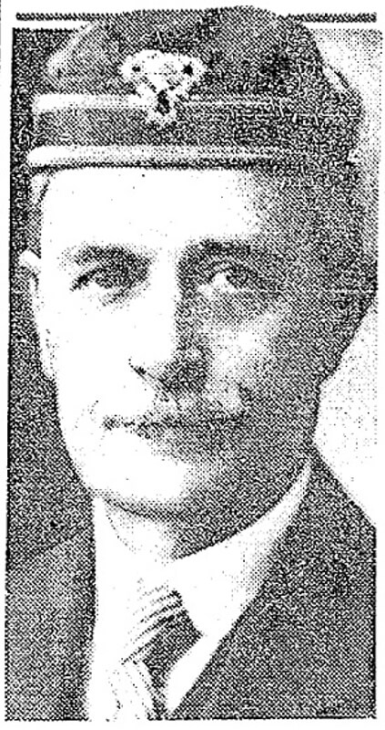
Frank Pardee Lewis, from his Seattle Times obituary, April 12, 1938
Born and raised in Seattle, Benjamin Donguk Lukoff had his interest in local history kindled at the age of six, when his father bought him settler granddaughter Sophie Frye Bass’s Pig-Tail Days in Old Seattle at the gift shop of the Museum of History and Industry. He studied English, Russian, and linguistics at the University of Washington, and went on to earn his master’s in English linguistics from University College London. His book of rephotography, Seattle Then and Now, was published in 2010. An updated version came out in 2015.
Rutan Place SW goes around 350 feet south from SW Edmunds Street between 44th Avenue SW and 45th Avenue SW to a dead end just short of 45th, though the undeveloped right-of-way does continue to that street.
Born and raised in Seattle, Benjamin Donguk Lukoff had his interest in local history kindled at the age of six, when his father bought him settler granddaughter Sophie Frye Bass’s Pig-Tail Days in Old Seattle at the gift shop of the Museum of History and Industry. He studied English, Russian, and linguistics at the University of Washington, and went on to earn his master’s in English linguistics from University College London. His book of rephotography, Seattle Then and Now, was published in 2010. An updated version came out in 2015.
This West Seattle street was created in 1907 as part of the plat of Adams 1st Addition to Fauntleroy Park, filed by John F. Adams (1860–1954) and his wife, Maggie W. True Adams (1864–1941). The document was notarized by Bert Avery Northrop (1880–1963), who was the husband of the Adamses’ daughter Abbie T. Adams (1888–1984). In his Seattle Times obituary, we learn that John Adams was “one of Fauntleroy’s first residents, [who]… came here in 1897. He first was in the grocery business and entered the real-estate business in 1903.… Mr. Adams was known as the ‘mayor of Fauntleroy.’” Meanwhile, Northrop’s Times obituary reports he came to Seattle in 1902 and began practicing law in 1906; he married Abbie Adams in 1909.
Bert A. Northrop
Northrop Place SW begins at SW Thistle Street and goes a block north to SW Southern Street.
Born and raised in Seattle, Benjamin Donguk Lukoff had his interest in local history kindled at the age of six, when his father bought him settler granddaughter Sophie Frye Bass’s Pig-Tail Days in Old Seattle at the gift shop of the Museum of History and Industry. He studied English, Russian, and linguistics at the University of Washington, and went on to earn his master’s in English linguistics from University College London. His book of rephotography, Seattle Then and Now, was published in 2010. An updated version came out in 2015.
This street was created in 1890 as part of the plat of the Bluff Park Addition to the City of Seattle, filed by Avery Parker of Arapahoe County, Colorado. Originally Arapahoe Avenue, it appears to have been named after that county, whose seat at the time was Denver. (The city was split off from the rest of the county in 1902.) Arapahoe County was itself named in 1861 for the Arapaho, a Native American people whose territory once included the area, but were subsequently forced onto reservations in Wyoming and Oklahoma.
Today, Arapahoe Place W begins at W Dravus Street and goes 450 feet north to just beyond W Prosper Street. It then resumes half a block north at W Bertona Street and goes ¼ mile north to W Emerson Street, along the south edge of Discovery Park.
Born and raised in Seattle, Benjamin Donguk Lukoff had his interest in local history kindled at the age of six, when his father bought him settler granddaughter Sophie Frye Bass’s Pig-Tail Days in Old Seattle at the gift shop of the Museum of History and Industry. He studied English, Russian, and linguistics at the University of Washington, and went on to earn his master’s in English linguistics from University College London. His book of rephotography, Seattle Then and Now, was published in 2010. An updated version came out in 2015.
Born and raised in Seattle, Benjamin Donguk Lukoff had his interest in local history kindled at the age of six, when his father bought him settler granddaughter Sophie Frye Bass’s Pig-Tail Days in Old Seattle at the gift shop of the Museum of History and Industry. He studied English, Russian, and linguistics at the University of Washington, and went on to earn his master’s in English linguistics from University College London. His book of rephotography, Seattle Then and Now, was published in 2010. An updated version came out in 2015.
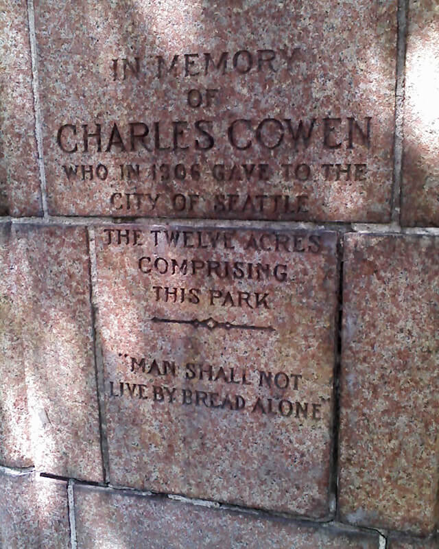
This street was created as part of the 1906 plat of Cowen’s University Park, filed by the Sylvester-Cowen Investment Company, of which Charles Cowen (1869–1926) was president. Originally Ravenna Place, it received its current name in 1918, according to an article in the January 29 issue of The Seattle Times. (This article also reported that the names of the individual streets that made up Queen Anne Boulevard would be restored and that Oriental Avenue [counterpart of the still-existing Occidental Avenue S] would become Third Avenue S). Whether it honors Cowen or the park named after him, which he donated to the city in 1906, is unclear.
Article in September 22, 1917, issue of The Seattle Times on Charles Cowen and his bounty on German leaders during World War I
Cowen was born in England, moved with his family to South Africa, and came to the United States in 1890, arriving in Seattle in 1900. Dotty DeCoster writes for HistoryLink.org:
Cowen was, by many accounts, a lively and active participant in developing the University District. According to architectural historian Shirley L. Courtois, he was British and had grown up in South Africa, where his family members were diamond miners and merchants. In 1890 he was sent to New York to purchase equipment for the mines. He never returned to South Africa. He apparently broke with his family, changed his name from Cohen to Cowen, and settled first in New York State, then in Florida, and finally in Seattle. Cowen reportedly retained a distinctively English style throughout his life.
The facts that his surname was originally Cohen and that his family was involved in diamond mining in South Africa led me to think he must have been Jewish, but I could find no definitive mention of his ethnicity online. However, in the March 19, 1926, issue of The Seattle Times, I found an article on the probate of his will, which mentioned that $2,000 of his $50,000 estate would go to the Hebrew Benevolent Society (today known as Jewish Family Service). That makes Cowen and Henry Fuhrman (1844–1907) (Fuhrman Avenue E) the only Jews I am aware of who have Seattle streets named after them.
Cowen Place NE begins at NE Ravenna Boulevard and University Way NE and goes just over 325 feet northeast to 15th Avenue NE, at the south end of the Cowen Park Bridge.
Born and raised in Seattle, Benjamin Donguk Lukoff had his interest in local history kindled at the age of six, when his father bought him settler granddaughter Sophie Frye Bass’s Pig-Tail Days in Old Seattle at the gift shop of the Museum of History and Industry. He studied English, Russian, and linguistics at the University of Washington, and went on to earn his master’s in English linguistics from University College London. His book of rephotography, Seattle Then and Now, was published in 2010. An updated version came out in 2015.
Born and raised in Seattle, Benjamin Donguk Lukoff had his interest in local history kindled at the age of six, when his father bought him settler granddaughter Sophie Frye Bass’s Pig-Tail Days in Old Seattle at the gift shop of the Museum of History and Industry. He studied English, Russian, and linguistics at the University of Washington, and went on to earn his master’s in English linguistics from University College London. His book of rephotography, Seattle Then and Now, was published in 2010. An updated version came out in 2015.
In History of Seattle from the Earliest Settlement to the Present Time, Clarence Bagley writes that Benton, who was born in Iowa and came to Seattle in 1890 from Montana,
…spent many years with different railroad companies. For a time he was connected with the Great Northern and later he became general passenger and freight agent for the Chicago, Burlington & Quincy Railroad at Seattle. The last few years of his life were spent in connection with the safe and lock trade. He was associated with the Norris Safe & Lock Company… Later Mr. Norris took over the safe and lock company and Mr. Benton the desk department of the business, after which he was joined by Edward Herald in a partnership that was continued under the name of the Benton-Herald Desk & Safe Company until [his death].
Born and raised in Seattle, Benjamin Donguk Lukoff had his interest in local history kindled at the age of six, when his father bought him settler granddaughter Sophie Frye Bass’s Pig-Tail Days in Old Seattle at the gift shop of the Museum of History and Industry. He studied English, Russian, and linguistics at the University of Washington, and went on to earn his master’s in English linguistics from University College London. His book of rephotography, Seattle Then and Now, was published in 2010. An updated version came out in 2015.
SW Teig Place begins at 57th Avenue SW just north of SW Stevens Street and goes around 450 feet northeast to 56th Avenue SW just north of SW Lander Place.
Born and raised in Seattle, Benjamin Donguk Lukoff had his interest in local history kindled at the age of six, when his father bought him settler granddaughter Sophie Frye Bass’s Pig-Tail Days in Old Seattle at the gift shop of the Museum of History and Industry. He studied English, Russian, and linguistics at the University of Washington, and went on to earn his master’s in English linguistics from University College London. His book of rephotography, Seattle Then and Now, was published in 2010. An updated version came out in 2015.


.jpg)