This West Seattle street was created as part of the plat of Woodside, an Addition to the City of Seattle, filed on June 17, 1919, by Eugene E. Harold, and named for the subdivision. I don’t think it’s too much of a stretch to assume the subdivision was so named because of its proximity to the wooded area that is now Lincoln Park.
Woodside Place SW begins at SW Myrtle Street just south of Gatewood Elementary School and goes just over 600 feet south to SW Othello Street.
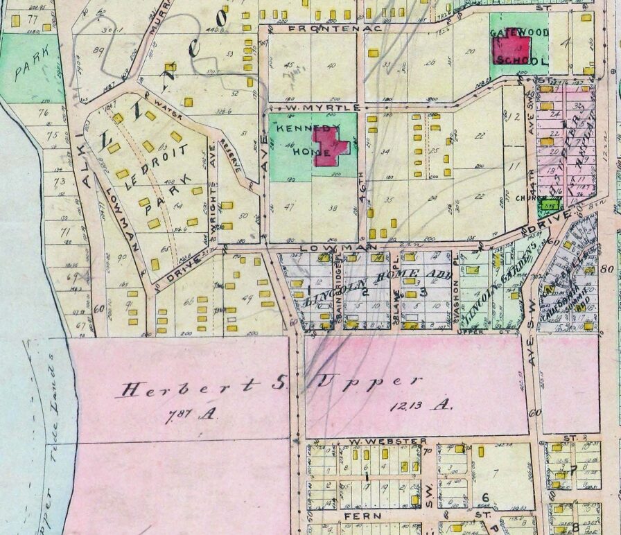
Detail of 1912 Baist atlas of Seattle showing current location of Woodside Place, south of W Myrtle Street (now SW Myrtle Street) just southwest of Gatewood Elementary School. The vacant land shaded in pink as and noted as belonging to Herbert S. Upper is now part of Lincoln Park (along Puget Sound) and Solstice Park, formerly Lincoln Park Annex (to the east, between what are now Fauntleroy Way SW and 44th Avenue SW).
Born and raised in Seattle, Benjamin Donguk Lukoff had his interest in local history kindled at the age of six, when his father bought him settler granddaughter Sophie Frye Bass’s Pig-Tail Days in Old Seattle at the gift shop of the Museum of History and Industry. He studied English, Russian, and linguistics at the University of Washington, and went on to earn his master’s in English linguistics from University College London. His book of rephotography, Seattle Then and Now, was published in 2010. An updated version came out in 2015.
This street, created in 1919 by Ordinance 39638, is named for W Marginal Way SW. It begins there and goes just under 800 feet northwest to a dead end underneath the West Seattle Bridge. The Duwamish Trail continues on from there to the West Seattle Bridge Trail, while the 18th Avenue SW stairway heads south up the hill to SW Charlestown Street in Pigeon Point.
Born and raised in Seattle, Benjamin Donguk Lukoff had his interest in local history kindled at the age of six, when his father bought him settler granddaughter Sophie Frye Bass’s Pig-Tail Days in Old Seattle at the gift shop of the Museum of History and Industry. He studied English, Russian, and linguistics at the University of Washington, and went on to earn his master’s in English linguistics from University College London. His book of rephotography, Seattle Then and Now, was published in 2010. An updated version came out in 2015.
Division, like Front, is usually a name applied to a major street, like Division Street in Chicago, or to a street that divides one section of town from another, like Division Street in Manhattan, or to a street that does both, like Division Street in Spokane. But in Seattle, Division Avenue NW goes only two blocks, from NW 65th Street to NW 70th Street, and doesn’t appear to serve as any sort of dividing line at all. Why is this?
My friend Rob Ketcherside, a local historian, put together this helpful database of and article on old Ballard street names, which got me on the right track. But what helped me figure out this riddle — at least I think I have — was this 1903 sewer map that Rob consulted and linked to. A portion of it appears below.
Portion of map of Ballard sewers, 1903, covering present-day intersection of Division Avenue NW and NW 65th Street. Courtesy of the Seattle Municipal Archives, Identifier 1588.
The CITY to the right of Division Avenue N just north of E Ship Street is actually part of BALLARD CITY BOUNDARY, which ran along what is today 8th Avenue NW… except between E Ship Street (65th) and E Sloop Street (70th). The boundary continued in a straight line, but Division Avenue jogged to the west, causing the boundary to go down the center of those two blocks. It appears that 8th Avenue NW was later put straight through (I’m not sure exactly when, but this Baist atlas plate from 1912 appears to have the extension penciled in), but the jog was never renamed to something like 8th Place NW.
And that’s — I think — how you get a two-block–long Division Avenue that doesn’t divide anything!
Born and raised in Seattle, Benjamin Donguk Lukoff had his interest in local history kindled at the age of six, when his father bought him settler granddaughter Sophie Frye Bass’s Pig-Tail Days in Old Seattle at the gift shop of the Museum of History and Industry. He studied English, Russian, and linguistics at the University of Washington, and went on to earn his master’s in English linguistics from University College London. His book of rephotography, Seattle Then and Now, was published in 2010. An updated version came out in 2015.
The meeting of 45th Street and Meridian Avenue began in the forest, when federal surveyors carrying their Gunter chains described — and marked — the future streets as the west (Meridian) and north (45th) borders for the 640 acres of federal land section number 17. That done, the settlers could identify their claims with some precision.
Indeed, King County’s quarter section map covering the intersection shows that (going clockwise) sections 7, 8, 17, and 18 of Township 25 North, Range 4 East, Willamette Meridian, meet there.
Meridian Avenue N begins at N Northlake Way just north of Gas Works Park and goes 1½ miles north to N 55th Street, where it becomes Kenwood Place N. It resumes at Kirkwood Place N just north of N 59th Street, and goes ¼ mile north to E Green Lake Way N. On the north side of the lake, there is a block-long stretch from E Green Lake Drive N to N 75th Street, and a longer, ¾-mile one from N 77th Street to N 92nd Street and North Seattle College. Meridian begins again at the north end of College Way N at N 103rd Street, and goes just under a mile to N 122nd Street, south of Haller Lake. It resumes on the north shore of the lake as a shoreline street end (though not on the city’s official list) and goes a mile north to the city limits at N 145th Street. As with most North Seattle avenues, the name continues into Shoreline, and in this case the arterial street itself keeps going for 3 more miles to the King–Snohomish county line at N 205th Street.
Born and raised in Seattle, Benjamin Donguk Lukoff had his interest in local history kindled at the age of six, when his father bought him settler granddaughter Sophie Frye Bass’s Pig-Tail Days in Old Seattle at the gift shop of the Museum of History and Industry. He studied English, Russian, and linguistics at the University of Washington, and went on to earn his master’s in English linguistics from University College London. His book of rephotography, Seattle Then and Now, was published in 2010. An updated version came out in 2015.
W Marginal Way SW, like its twin across the water, E Marginal Way S, began literally as a “marginal way” to “give railroads, street cars and other transportation facilities access to the Duwamish waterway.”
W Marginal Way SW begins at 26th Avenue SW at the Port of Seattle’s Terminal 5. From there, it’s 3 miles southeast to 2nd Avenue SW, by the south end of the 1st Avenue S Bridge. It resumes on the east side of the bridge as W Marginal Way S, an extension of Highland Park Way SW, and runs 4⅖ miles from there to the southern city limits. (For all but the first few blocks of this stretch, it is a limited-access highway carrying Washington State Route 99.) Beyond there it runs 3½ miles more to the vicinity of an interchange with Tukwila International Boulevard. The name is dropped at this point (and does not appear on signs south of the initial few blocks); the highway continues 1¾ miles as Washington State Route 599 to Interstate 5.
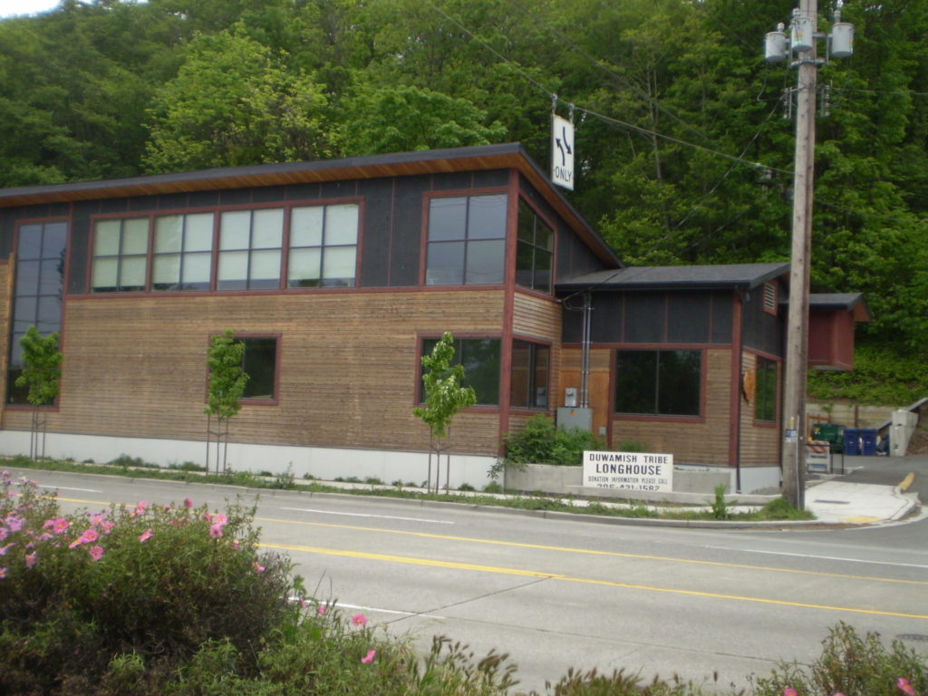
W Marginal Way S is the location of the Duwamish Longhouse and Cultural Center, across the street from həʔapus Village Park and Shoreline Habitat (formerly Terminal 107 Park). həʔapus, or x̌əʔapus, was the name of a Duwamish village that was burned down by settlers in 1895. The new longhouse became the first one within city limits in 114 years. Notably, descendants of settlers Charles Terry and David Denny participated in fundraising and advocacy, without which the project would have been impossible, as the Duwamish were forced to purchase back the land. (A good article for more detail is “On the Duwamish River, a longhouse rises,” which appeared in Real Change in March 2009.)
Plan of the Duwamish Waterway, from the August 31, 1913, issue of the Seattle Post-Intelligencer, page 44
Born and raised in Seattle, Benjamin Donguk Lukoff had his interest in local history kindled at the age of six, when his father bought him settler granddaughter Sophie Frye Bass’s Pig-Tail Days in Old Seattle at the gift shop of the Museum of History and Industry. He studied English, Russian, and linguistics at the University of Washington, and went on to earn his master’s in English linguistics from University College London. His book of rephotography, Seattle Then and Now, was published in 2010. An updated version came out in 2015.
E Marginal Way S and its twin across the Duwamish Waterway, W Marginal Way SW, are good examples of purely descriptive Seattle street names. In fact, they are first mentioned in the press as adjective + noun, not name + type:
“Marginal ways are urged for both sides of Duwamish waterway.” Seattle Post-Intelligencer, October 27, 1911, in reference to the Bogue Plan
“Coincident with the completion of the Duwamish waterway and the wide marginal streets on each side, a publicly owned railway should be built along these marginal ways…” C.C. Closson, realtor and the Port of Seattle’s first paid employee, in a letter to the editor, Seattle P-I, July 8, 1912
“East and west marginal ways, planned by Bogue to parallel the waterway to give railroads, street cars and other transportation facilities access to the Duwamish waterway, will both pass through Oxbow.“ The Seattle Times, March 26, 1914
“Marginal ways parallel the new waterway for the whole distance, connecting with the main streets of the city running to the south.” Seattle P-I, August 13, 1914
A longer excerpt, from an article in the April 19, 1914, issue of The Seattle Times, explains the reason for their creation:
Second only in importance to the waterway are the projected traffic streets, east and west marginal ways, laid out on both sides of the waterway about 1,000 feet back to give railways and street car lines the opportunity to parallel the waterway on both sides for its entire length, to give service to the industries locating along the waterway. As an allowance of $175,000 was made for East Marginal Way in the $3,000,000 county bond issue for roads, that street is now being condemned by the city and will be constructed 130 feet wide to the south city limits, where it will join a county road. West Marginal Way is also being promoted by interested property owners. As the existing railways are already but a short distance east of the Duwamish River, spurs can be thrown into East Marginal Way at slight expense. Also the port commission is considering a plan for port district terminal tracks on the Marginal Ways to serve the waterway.
The Duwamish Waterway, whose construction began on October 14, 1913, was a straightening and deepening of the last 6 miles of the formerly meandering river. Construction of the waterway, with Harbor Island at its mouth (the largest artificial island in the world from 1909 to 1938), plus the filling of the Elliott Bay tidelands, are what give Seattle’s harbor its modern shape.
Plan of the Duwamish Waterway, from the August 31, 1913, issue of the Seattle Post-Intelligencer, page 44
E Marginal Way S begins as an extension of Alaskan Way S — originally Railroad Avenue, which served much the same function for the central waterfront — at the Port of Seattle’s Terminal 30, and stretches 4⅖ miles from there to the southern city limits. (From the southern end of the Alaskan Freeway to the northern end of the 1st Avenue South Bridge, it carries Washington State Route 99.) Beyond there it runs 3½ miles more to S 133rd Street in Tukwila.
Born and raised in Seattle, Benjamin Donguk Lukoff had his interest in local history kindled at the age of six, when his father bought him settler granddaughter Sophie Frye Bass’s Pig-Tail Days in Old Seattle at the gift shop of the Museum of History and Industry. He studied English, Russian, and linguistics at the University of Washington, and went on to earn his master’s in English linguistics from University College London. His book of rephotography, Seattle Then and Now, was published in 2010. An updated version came out in 2015.
This Industrial District street — a mere 80 feet long — runs from Airport Way S east to the Interstate 5 right-of-way. It may very well be the shortest street in Seattle (I’d love to hear about other candidates).
As explained in SW Seattle Street, the plat of Judkin’s Addition to the Town of Seattle was filed in 1869. From north to south, the east–west streets are named Norman, B, Judkins, Addition, Town, and Seattle. (Did they really think B Street would last, I wonder?)
Of these, Norman, Judkins, Addition, and Seattle Streets remain, though Addition is the only one still in its original location. (SW Seattle Street now only exists for a few blocks in West Seattle, and S Norman and S Judkins Streets only east of Interstate 5.)
Born and raised in Seattle, Benjamin Donguk Lukoff had his interest in local history kindled at the age of six, when his father bought him settler granddaughter Sophie Frye Bass’s Pig-Tail Days in Old Seattle at the gift shop of the Museum of History and Industry. He studied English, Russian, and linguistics at the University of Washington, and went on to earn his master’s in English linguistics from University College London. His book of rephotography, Seattle Then and Now, was published in 2010. An updated version came out in 2015.


