This street was created in 1915 by renaming portions of Hugo Place, Grand Avenue, and E Denny Way. It was named after the Madrona neighborhood, itself named after Madrona Park, which in turn was named for the madrona or Pacific madrone tree(Arbutus menziesii). According to Seattle parks historian Don Sherwood, this was not because of the tree’s prevalence in the area — if they are characteristic of any Seattle neighborhood, it would be Magnolia. Rather,
J.E. Ayer, one of the “contributors” [of land for the park], suggested “Madrona,” based upon the presence of a few trees in the community — but scarcely more than a “few little (madrona) sprouts” in the park area. However, the name caught on and soon became the district name as well.
Madrona Drive begins at the intersection of E Denny Way, 38th Avenue, and Madrona Place E, and goes nearly ½ a mile southeast to Lake Washington Boulevard just north of Madrona Park.
Born and raised in Seattle, Benjamin Donguk Lukoff had his interest in local history kindled at the age of six, when his father bought him settler granddaughter Sophie Frye Bass’s Pig-Tail Days in Old Seattle at the gift shop of the Museum of History and Industry. He studied English, Russian, and linguistics at the University of Washington, and went on to earn his master’s in English linguistics from University College London. His book of rephotography, Seattle Then and Now, was published in 2010. An updated version came out in 2015.
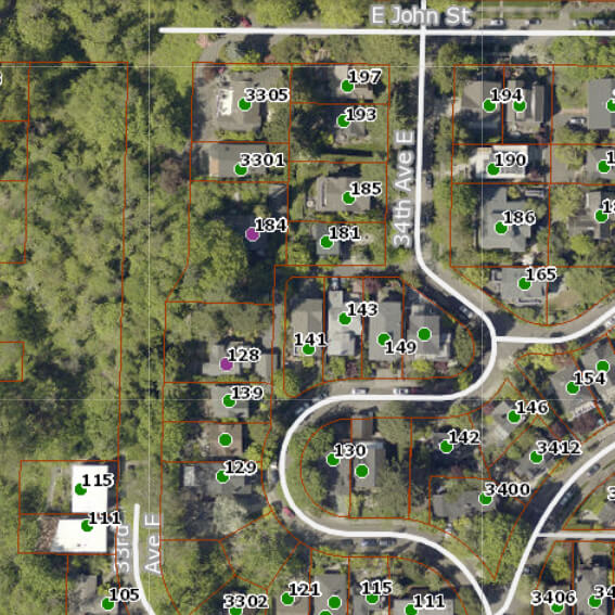
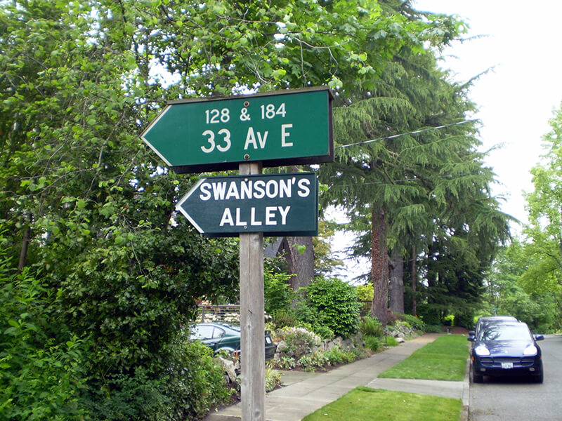
Officially, this alley off 34th Avenue E between E John Street and 35th Avenue E is unnamed. That proved inconvenient for Jack Sussman and Cathy Nunneley, who live at 184 and 128 33rd Avenue E, respectively. Yes, 33rd Avenue E, even though their house is accessed from 34th.
I don’t know how it works in other cities, but in Seattle, you can have an address on a nonexistent — or, more accurately, unimproved — street. This is the case with W Semple Street — the three residences with a Semple address are only accessible from 45th Avenue W. And this is the case here. Unlike Semple, 33rd Avenue E is improved… but not for the entire length of its right-of-way. From about 450 feet south of E Harrison Street to about 175 feet north of E Denny Way, 33rd Avenue E is unimproved and makes up part of the Harrison Ridge Greenbelt.
Swanson’s Alley and surrounding streets as shown on King County Parcel Viewer. Address points appear in green, except for 128 and 184 33rd Avenue E, which appear in purple.
We have a problem because our address is one that people cannot find. Get a new mailperson and we won’t see any mail for a week!… How many Roto-Rooter men, phone line fixers, and Craigslist contacts have been lost trying to find us? GPS and MapQuest systems are useless for locating my house. How many times have I run out to the street vainly searching for the delivery truck going round and round the neighborhood?
He goes on to explain that “a fine article lamenting [the] neglect of city alleys” written by Knute Berger inspired him to put up a sign reading “Swanson’s Alley” underneath the city’s official sign directing people to his and Nunneley’s houses. He chose the name to honor “Swanson, a Swedish carpenter, [who] lived here in the 1930s,” and happily reports that giving the alley a name, albeit unofficial, did indeed help people find his residence.
In the next issue of The Valley View, Sussman reports that he was able to locate a grandson of this Swanson, to give him the news and get further details on the alley’s namesake:
The grandfather who founded the family here was Elof Svenson [1881–1958]; the name later became Swanson in America. Elof was a teenage laborer, a Swedish immigrant who spoke little English. I had one detail wrong: he was not a carpenter but a landscape worker who specialized in rockeries. He put in all the bulkheads that hold the ground above the Harrison Greenbelt.
In general, I’m not a fan of unofficial signage (especially signs proclaiming public rights-of-way to be private, which I’ve come across in Blue Ridge, Montlake, and Wedgwood) but I have no problem with this one. It doesn’t imply private ownership and it’s meant to improve navigation. And it honors someone most people would otherwise never have heard of.
By the way — in case you’re wondering why Swanson’s Alley shows up in Google Maps and OpenStreetMap even though the name is unofficial, it’s because I added it. The name, that is — the alley was already present on both. (I’m trying to get it added to Apple Maps as well, but that may be a bit more difficult.)
Born and raised in Seattle, Benjamin Donguk Lukoff had his interest in local history kindled at the age of six, when his father bought him settler granddaughter Sophie Frye Bass’s Pig-Tail Days in Old Seattle at the gift shop of the Museum of History and Industry. He studied English, Russian, and linguistics at the University of Washington, and went on to earn his master’s in English linguistics from University College London. His book of rephotography, Seattle Then and Now, was published in 2010. An updated version came out in 2015.
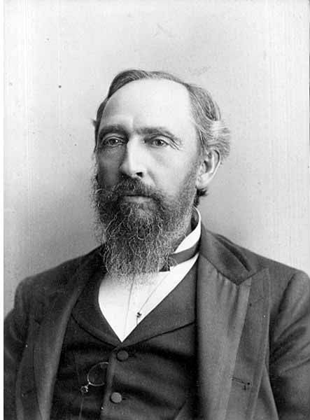
This street is named for David Thomas Denny (1832–1903). He was one of the members of the Denny Party that landed at Alki Point in 1851, led by his older brother, Arthur Armstrong Denny (1822–1899). In 1853, he married his sister-in-law, Louisa Boren (1827–1916). (Louisa’s older sister, Mary Ann Boren [1822–1910], had married Arthur in 1843. She, Louisa, and their brother, Carson Dobbins Boren [1824–1912], were also part of the Denny Party).
The Dennys settled on land in what is now Lower Queen Anne, living in a series of houses in the area until they went bankrupt in the Panic of 1893 and had to leave their mansion for their summer cottage at Licton Springs, where they lived with their oldest child, Emily Inez Denny (1853–1918), until they died.
Denny Park is named for the couple, which had given the land to the city as its first cemetery in 1861; the bodies were moved to the Washelli Cemetery on Capitol Hill in the 1880s, at which time the original cemetery was converted to a park, likewise the city’s first. (Just a few years later, Washelli was also converted to a park, initially known as Lake View Park, then City Park, and finally, in 1901, Volunteer Park. The Dennys’ private burial ground near the no-longer-existent Oak Lake eventually became the Oaklake Cemetery, which, after being sold by their son Victor in 1914, was renamed Washelli after the original cemetery of that name; Evergreen Cemetery, across Aurora Avenue N from Washelli, bought the latter in 1922, and the combined cemetery took its current name, Evergreen Washelli, in 1962.)
David Denny was active in government. According to HistoryLink.org, he was:
…Probate judge, King County commissioner, Seattle City Council member, a director of the Seattle School District, and regent of the Territorial University of Washington.… Denny was an ardent advocate of woman suffrage and helped lead the movement that in the 1880s won Washington women the right to vote. He opposed the expulsion of Chinese immigrants in 1886, which antagonized local nativists.
Denny was also involved in the development of a number of Seattle neighborhoods; in addition to Queen Anne, he developed tracts in South Lake Union, Capitol Hill, and Ravenna, and founded the Rainier Power and Railway Company, which ran the first streetcar from Downtown (Pioneer Square) to the University District (Ravenna Park).
David T. Denny, 1890. Courtesy of the Seattle Municipal Archives, Identifier 175313.
Denny Way — originally named Depot Street by Denny after a proposed train station that never materialized — begins as a shoreline street end on Elliott Bay, indistinguishable from the surrounding Myrtle Edwards Park. On the other side of the BNSF Railway tracks, W Denny Way begins as a pathway and stairway from Elliott Avenue to Western Avenue. From here, it is a major arterial, becoming Denny Way as it crosses Queen Anne Avenue N (originally named Temperance Street by Denny), and going 2½ miles east to E Madison Street and 22nd Avenue. (It becomes a neighborhood street on crossing E Olive Way, and the block between Broadway and 10th Avenue E was renamed E Barbara Bailey Way in 2019). E Denny Way begins again at E Madison Street and 23rd Avenue and goes ⅘ of a mile east to Madrona Place E and 38th Avenue, where it turns into Madrona Drive.
Denny Way, which becomes E Denny Way east of Eastlake Avenue E, also divides five of the city’s directional designation zones from each other, similarly to Yesler Way. North of Denny but west of Queen Anne Avenue N, east–west streets carry the W prefix and north–south avenues carry the suffix W. North of Denny between Queen Anne Avenue N and Eastlake Avenue E, east–west streets carry no prefix and north–south avenues carry the suffix N. North of Denny east of Eastlake Avenue E, east–west streets carry the E prefix and north–south avenues carry the suffix E. South of Denny but west of a line that includes Melrose Avenue, Minor Avenue, E Union Street, and Broadway, neither east–west streets nor north–south avenues carry a prefix or suffix. And south of Denny but east of that line, east–west streets carry the E prefix and north–south avenues carry no suffix.
Born and raised in Seattle, Benjamin Donguk Lukoff had his interest in local history kindled at the age of six, when his father bought him settler granddaughter Sophie Frye Bass’s Pig-Tail Days in Old Seattle at the gift shop of the Museum of History and Industry. He studied English, Russian, and linguistics at the University of Washington, and went on to earn his master’s in English linguistics from University College London. His book of rephotography, Seattle Then and Now, was published in 2010. An updated version came out in 2015.
Howell was captain of the SS Pacific, en route from Victoria to San Francisco, when it sank off Cape Flattery the evening of November 4, 1875. Only one passenger and one crew member survived of nearly 275 aboard, making it the worst maritime disaster on the West Coast to date. As Daryl C. McClary writes for HistoryLink.org:
Although lost at sea, Jefferson Davis Howell was not forgotten by his many friends in Puget Sound. They had a 10-foot-tall sandstone obelisk erected in his memory at the Seattle Masonic Cemetery, established in 1872 and renamed the Lake View Cemetery in 1890. On the base of the monument is chiseled the simple epitaph: “Captain J. D. Howell, perished at sea on the steamship Pacific, November 4, 1875, aged 34 years.”
Howell Street begins at 8th Avenue and Olive Way and goes ⅓ of a mile northwest to Eastlake Avenue, just west of Interstate 5. On the other side of the freeway, it resumes at Bellevue Avenue as E Howell Street and goes ⅕ of a mile east to Harvard Avenue, where it is blocked by Seattle Central College. After a very short segment between Broadway and Nagle Place, it begins again east of Cal Anderson Park at 11th Avenue and goes ½ a mile east to 19th Avenue. E Howell Street resumes at Homer Harris Park at 24th Avenue and goes ¾ of a mile east to 38th Avenue, being a stairway and pathway between the alley east of 25th Avenue and 26th Avenue. It begins again at Madrona Drive and goes ⅒ of a mile east to 39th Avenue E and Evergreen Place. Its last segment is just over 100 feet long, from Lake Washington Boulevard to Howell Place and Howell Park beach.
Born and raised in Seattle, Benjamin Donguk Lukoff had his interest in local history kindled at the age of six, when his father bought him settler granddaughter Sophie Frye Bass’s Pig-Tail Days in Old Seattle at the gift shop of the Museum of History and Industry. He studied English, Russian, and linguistics at the University of Washington, and went on to earn his master’s in English linguistics from University College London. His book of rephotography, Seattle Then and Now, was published in 2010. An updated version came out in 2015.
“A street of good intentions but easily thwarted,” as Sophie Frye Bass puts it in Pig-Tail Days in Old Seattle, John Street is “named for two Johns,” she writes — “For John Denny [1793–1875], the father of Arthur and David, and John B. [1862–1913], the son of David.”
John Denny
John Bunyan Denny
Today, W John Street begins at Western Avenue W and goes ⅓ of a mile east to 2nd Avenue N and the Pacific Science Center campus. John Street resumes just east of the Space Needle at Broad Street and goes ½ a mile to Terry Avenue N. Picking up half a block to the east, it makes it a further ⅓ of a mile before being blocked by Interstate 5 at Stewart Street and Eastlake Avenue E. Resuming at Melrose Avenue E, it goes ⅙ of a mile to E Olive Way, which itself becomes E John Street a few blocks to the east at Broadway E. From there, it’s ⅓ of a mile to the Kaiser Permanente Capitol Hill Medical Center at 15th Avenue E. After beginning again at 16th Avenue E, E John makes it nearly a mile before being stopped by the Harrison Ridge Greenbelt at 32nd Avenue E. Its final stretch is ⅓ of a mile from the 33rd Avenue E right-of-way to 39th Avenue E at Viretta Park.
Born and raised in Seattle, Benjamin Donguk Lukoff had his interest in local history kindled at the age of six, when his father bought him settler granddaughter Sophie Frye Bass’s Pig-Tail Days in Old Seattle at the gift shop of the Museum of History and Industry. He studied English, Russian, and linguistics at the University of Washington, and went on to earn his master’s in English linguistics from University College London. His book of rephotography, Seattle Then and Now, was published in 2010. An updated version came out in 2015.
This short loop connects Lake Washington Boulevard E to 40th Avenue E and Denny Blaine Park on the Lake Washington waterfront. Street, park, and neighborhood — for the neighborhood is called Denny-Blaine too, though this time with a hyphen — are named for Charles Latimer Denny (1861–1919) and Elbert F. Blaine (1857–1942).
Denny was the youngest son of Arthur Armstrong Denny, leader of the Denny Party that landed at Alki Point in 1851; Blaine was a lawyer and parks commissioner from 1902 to 1908, and does not appear to be related to Catherine and David Blaine, after whom Blaine Street is named. Together, they operated the Denny-Blaine Land Company, and in 1901 filed the plat of Denny-Blaine-Lake Park to the City of Seattle (curiously, “Addition” seems to be missing before “to”). The street was originally named Whitman Place, and the park was unnamed; according to Seattle parks historian Don Sherwood, the street was renamed in 1918 to avoid confusion with Whitman Avenue N, and the park soon came to be known as Denny Blaine as well.
Charles Latimer Denny
Elbert F. Blaine
Incidentally, both portraits come from scans of newspapers; Blaine’s is from The Seattle Republican, September 27, 1912, and Denny’s is from the Seattle Post-Intelligencer, May 14, 1919 (his obituary). The original caption reads, in part:
The above photograph of Charles L. Denny was the last one he ever had taken. It was taken in the early nineties… and shows Mr. Denny, in the crude photography of that time, as he appeared when starting out on his successful business career.
Born and raised in Seattle, Benjamin Donguk Lukoff had his interest in local history kindled at the age of six, when his father bought him settler granddaughter Sophie Frye Bass’s Pig-Tail Days in Old Seattle at the gift shop of the Museum of History and Industry. He studied English, Russian, and linguistics at the University of Washington, and went on to earn his master’s in English linguistics from University College London. His book of rephotography, Seattle Then and Now, was published in 2010. An updated version came out in 2015.
This street is named for Thomas Dickerson Mercer (1813–1898), who came to Seattle in 1853 and homesteaded 160 acres in what is now Lower Queen Anne, living at what is now Roy Street and Taylor Avenue N. He became a King County commissioner and probate judge, and named Lake Washington and Lake Union, whose Lushootseed names are x̌ačuʔ and xáx̌əʔčuʔ(‘lake’ and its diminutive, respectively). Mercer Island is named for him, as are three of its main streets, W Mercer Way, N Mercer Way, and E Mercer Way. Mercer Slough in Bellevue is named for his brother Aaron (1826-1902), and his brother Asa (1839–1917) is known for being the first instructor at, and first president of, the Territorial University of Washington (being the only college graduate in Seattle in 1861); and for bringing the “Mercer Girls” to Seattle to address the settlement’s severe gender imbalance (thereby inspiring the 1960s TV show Here Come the Brides).
Thomas Dickerson Mercer
Today, W Mercer Street begins at Elliott Avenue W and goes a block east to 6th Avenue W, where it becomes a stairway. At the top of the stairway, the street becomes a major arterial (connecting directly to Elliott via W Mercer Place) and goes 1⅔ miles east to Eastlake Avenue E and Lakeview Boulevard E, where it is blocked by Interstate 5. (It is, incidentally, laid out on the boundary between the donation land claims of Mercer and David Thomas Denny. Mercer’s claim is today bounded by Queen Anne Avenue N on the west, Lake Union on the east, Highland Drive on the north, and Mercer Street on the south.) Connecting Interbay, Lower Queen Anne, Seattle Center, State Route 99, South Lake Union, Interstate 5, and Capitol Hill, Mercer Street is a linchpin of Seattle’s transportation system — but not a beloved one, having earned the name “Mercer Mess” decades ago.
East of Interstate 5, E Mercer Street begins again at Melrose Avenue E and goes nearly 1½ miles to 28th Avenue E, interrupted only once, at 17th Avenue E, where it is pedestrian-only for half a block. Mercer resumes briefly at Dewey Place E but after a couple hundred feet becomes a stairway connecting to Lake Washington Boulevard E and 31st Avenue E. A block east of that, at 32nd Avenue E, E Mercer Street resumes as another stairway, and becomes a street again just west of 33rd Avenue E. This segment goes about ⅛ of a mile to 36th Avenue E. There is one final 200-foot-long segment of E Mercer Street east of 39th Avenue E. Platted into Lake Washington, this is a shoreline street end, but not, unfortunately, one open to the public. (It was this particular street end that first got me involved with Friends of Street Ends, as I grew up just ¼ of a mile up the hill.)
Born and raised in Seattle, Benjamin Donguk Lukoff had his interest in local history kindled at the age of six, when his father bought him settler granddaughter Sophie Frye Bass’s Pig-Tail Days in Old Seattle at the gift shop of the Museum of History and Industry. He studied English, Russian, and linguistics at the University of Washington, and went on to earn his master’s in English linguistics from University College London. His book of rephotography, Seattle Then and Now, was published in 2010. An updated version came out in 2015.
Dillis Ward, when a young man, did his part in building the old University for he drove a team that hauled stone and lime for the foundation. After the building was finished, he entered as a pupil into the first class. He taught school later on, and many an old-timer can recall the genial, kindly school teacher.
According to this biography, Ward, who came to Seattle in 1859, also had a hand in founding both The Post (a predecessor of the Seattle Post-Intelligencer) and The Seattle Daily Chronicle (a predecessor of The Seattle Times). However, his name does not appear in Professor Edmond S. Meany’s Newspapers of Washington Territory, in this article on the Post Building from the Pacific Coast Architecture Database, or in this HistoryLink article on the history of the P-I. All of them do mention brothers Kirk C. and Mark Ward, but Dillis’s entry at FamilySearch mentions no siblings, and Mark and Kirk’s entries do not mention Dillis. However, they do appear to have the same father, Jesse Ward. It looks as if Dillis was Jesse’s son from his first marriage, to Elizabeth Raley. As she died the same year Dillis was born, it may have been in childbirth. Kirk and Mark appear to be Jesse’s sons from his subsequent marriage to Exeline Cason. Exactly what part he may have played in the founding of the papers, and why this is missing from the articles above (and, incidentally, from Pig-Tail Days, which one would think might have mentioned this fact) is unclear.
Ward Street begins at Queen Anne Avenue N and goes ⅗ of a mile east to Aurora Avenue N. There is a short segment of E Ward Street on Capitol Hill between 14th Avenue E and 15th Avenue E, followed by another one, ⅓ of a mile long, from 23rd Avenue E and Turner Way E down the hill to 29th Avenue E and E Aloha Street, at the west end of Washington Park Playfield. There follows another one-block segment on the other side of the park, between 31st Avenue E and 32nd Avenue E, and a final segment from 34th Avenue E to 37th Avenue E.
Born and raised in Seattle, Benjamin Donguk Lukoff had his interest in local history kindled at the age of six, when his father bought him settler granddaughter Sophie Frye Bass’s Pig-Tail Days in Old Seattle at the gift shop of the Museum of History and Industry. He studied English, Russian, and linguistics at the University of Washington, and went on to earn his master’s in English linguistics from University College London. His book of rephotography, Seattle Then and Now, was published in 2010. An updated version came out in 2015.
Today, W Republican Street begins a block west of 4th Avenue W and goes ⅖ of a mile east to Warren Avenue N, where it becomes Seattle Center’s pedestrian August Wilson Way. On the east side of Seattle Center, there is a one-block segment of Republican Street between 4th Avenue N and 5th Avenue N; the street then resumes at Dexter Avenue N at the northbound exit from the State Route 99 Tunnel. From there, it runs ⅔ of a mile east to Eastlake Avenue E, where it is blocked by Interstate 5. Resuming east of I-5 as a stairway at Melrose Avenue E, it becomes a street again after half a block and goes another 1⅕ miles from Bellevue Avenue E to 23rd Avenue E, interrupted only once at 17th Avenue E, which can only be crossed by pedestrians and bicycles. After a substantial gap, E Republican Street begins again at 29th Avenue E and E Arthur Place in Madison Valley, and goes ⅖ east to its end at Lake Washington Boulevard E.
(From 33rd Avenue E to Lake Washington Boulevard E, it forms the northern boundary of the Bush School campus; when I went there in the 1980s and 1990s, people from out of town thought I was joking when I told them I went to Bush School on Republican Street. The school, of course, wasn’t named for a member of the Bush political dynasty, but rather for its founder, Helen Taylor Bush.)
Born and raised in Seattle, Benjamin Donguk Lukoff had his interest in local history kindled at the age of six, when his father bought him settler granddaughter Sophie Frye Bass’s Pig-Tail Days in Old Seattle at the gift shop of the Museum of History and Industry. He studied English, Russian, and linguistics at the University of Washington, and went on to earn his master’s in English linguistics from University College London. His book of rephotography, Seattle Then and Now, was published in 2010. An updated version came out in 2015.
This street, which appears to have been established as part of the 1906 Replat of McGilvra’s Addition and Second Addition to the City of Seattle (an abbreviation of its much longer name), was named for John J. McGilvra (1827–1903). Born in Livingston County, New York, McGilvra moved to Illinois at the age of 17, and became a lawyer nine years later. In 1861, President Abraham Lincoln, who McGilvra reportedly knew as a fellow Illinois lawyer, appointed him United States Attorney for the Territory of Washington. In 1864, he moved to Seattle. That same year, he and his wife, Elizabeth, bought 420 acres of land in what is now Madison Park and became the area’s first settlers. McGilvra had Madison Street extended to the lakefront — it is still the only street to extend from Elliott Bay to Lake Washington without interruption — and later helped establish the Madison Street Cable Railway Company and Madison Park at its eastern terminus. In 1865 he relinquished the post of U.S. attorney. He was a member of the Territorial Legislature in 1866 and 1867, and Seattle city attorney in 1876 and 1877. He retired in 1890.
John J. McGilvra, circa 1890
Today, McGilvra Boulevard E begins in the south at 39th Avenue E and Lake Washington Boulevard E and goes 1⅖ miles north to E McGilvra Street. Unlike most other boulevards in the city, it is not an Olmsted boulevard — McGilvra was reportedly opposed to the movement that resulted in the hiring of the Olmsted Brothers in 1903 (the year of his death) to design a system of parks and boulevards for Seattle, though there is no evidence the two are directly related.
Born and raised in Seattle, Benjamin Donguk Lukoff had his interest in local history kindled at the age of six, when his father bought him settler granddaughter Sophie Frye Bass’s Pig-Tail Days in Old Seattle at the gift shop of the Museum of History and Industry. He studied English, Russian, and linguistics at the University of Washington, and went on to earn his master’s in English linguistics from University College London. His book of rephotography, Seattle Then and Now, was published in 2010. An updated version came out in 2015.
Born and raised in Seattle, Benjamin Donguk Lukoff had his interest in local history kindled at the age of six, when his father bought him settler granddaughter Sophie Frye Bass’s Pig-Tail Days in Old Seattle at the gift shop of the Museum of History and Industry. He studied English, Russian, and linguistics at the University of Washington, and went on to earn his master’s in English linguistics from University College London. His book of rephotography, Seattle Then and Now, was published in 2010. An updated version came out in 2015.
Madison Street — another of Seattle’s “first streets” — was named for James Madison, president of the United States from 1809 to 1817. It is the only street in town that stretches, uninterrupted, from the salt water of Elliott Bay and Puget Sound to the fresh water of Lake Washington.
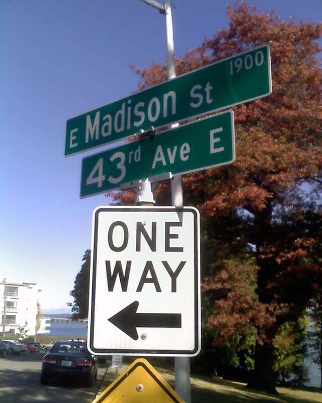
Originating as the McGilvra Road in 1861, Madison Street begins on the Elliott Bay waterfront at Alaskan Way and ends 3¾ miles northeast of there at a small fishing pier, just east of 43rd Avenue E and north of Madison Park Beach. Apart from a slight bend to the northeast at 22nd Avenue, it is as straight as an arrow from beginning to end.
Born and raised in Seattle, Benjamin Donguk Lukoff had his interest in local history kindled at the age of six, when his father bought him settler granddaughter Sophie Frye Bass’s Pig-Tail Days in Old Seattle at the gift shop of the Museum of History and Industry. He studied English, Russian, and linguistics at the University of Washington, and went on to earn his master’s in English linguistics from University College London. His book of rephotography, Seattle Then and Now, was published in 2010. An updated version came out in 2015.
This street runs just over ¼ of a mile from 37th Avenue E in the north, by Lakeview Park, to E Howell Street and 39th Avenue in the south. It was named for George and Otilde Dorffel, who might otherwise be best known for giving Ravenna its name.
In the original 1901 plat of Denny-Blaine-Lake Park, the Dorffel Drive name was given to what is now Madrona Place E, and what is now Dorffel Drive was then 37th Avenue. The change, which took place in 1906, would seem to have been done to eliminate the oddity of 39th Avenue becoming 37th Avenue as it crossed E Howell Street.
Born and raised in Seattle, Benjamin Donguk Lukoff had his interest in local history kindled at the age of six, when his father bought him settler granddaughter Sophie Frye Bass’s Pig-Tail Days in Old Seattle at the gift shop of the Museum of History and Industry. He studied English, Russian, and linguistics at the University of Washington, and went on to earn his master’s in English linguistics from University College London. His book of rephotography, Seattle Then and Now, was published in 2010. An updated version came out in 2015.
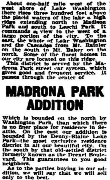
This street runs around 650 feet from 34th Avenue E, just north of E Denny Way, to 37th Avenue East. It was established in 1903 as part of Waddell’s Madrona Park Addition to the City of Seattle by, among others, Albert and Florence M. Waddell.
Advertisement for Madrona Park Addition, The Seattle Times, April 7, 1903
Born and raised in Seattle, Benjamin Donguk Lukoff had his interest in local history kindled at the age of six, when his father bought him settler granddaughter Sophie Frye Bass’s Pig-Tail Days in Old Seattle at the gift shop of the Museum of History and Industry. He studied English, Russian, and linguistics at the University of Washington, and went on to earn his master’s in English linguistics from University College London. His book of rephotography, Seattle Then and Now, was published in 2010. An updated version came out in 2015.
This short street in the Washington Park neighborhood runs just over a tenth of a mile from Lake Washington Boulevard E in the west to 36th Avenue E in the east, a block south of E Mercer Street.
The Pacific Coast Company rail, shipping and coal operations served the West Coast from the mid-19th century until its last railways were abandoned or sold in the mid-20th century. Though the company was organized under the Pacific Coast Company name in late 1897, it comprised several existing organizations, most notably the Pacific Coast Steamship Co., Pacific Coast Coal Co., and the Pacific Coast Railway. In Seattle, the Columbia & Puget Sound Railroad, originally the Seattle & Walla Walla, became part of the Pacific Coast Railway in 1916. The several operations of Pacific Coast Co., which also included a cement company and engineering company, played an important role in the development of King County resources and the development of Seattle and outlying communities.
Born and raised in Seattle, Benjamin Donguk Lukoff had his interest in local history kindled at the age of six, when his father bought him settler granddaughter Sophie Frye Bass’s Pig-Tail Days in Old Seattle at the gift shop of the Museum of History and Industry. He studied English, Russian, and linguistics at the University of Washington, and went on to earn his master’s in English linguistics from University College London. His book of rephotography, Seattle Then and Now, was published in 2010. An updated version came out in 2015.


