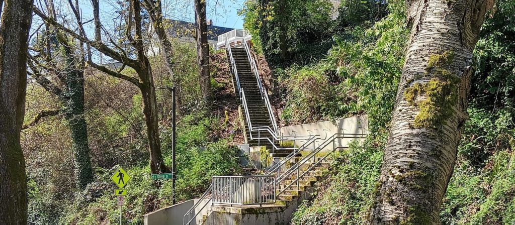
E Olive Lane begins at Lake Washington Boulevard at the bottom of the E Olive Street stairway and, passing Howell Place, goes around 380 feet east to Lake Washington.
Born and raised in Seattle, Benjamin Donguk Lukoff had his interest in local history kindled at the age of six, when his father bought him settler granddaughter Sophie Frye Bass’s Pig-Tail Days in Old Seattle at the gift shop of the Museum of History and Industry. He studied English, Russian, and linguistics at the University of Washington, and went on to earn his master’s in English linguistics from University College London. His book of rephotography, Seattle Then and Now, was published in 2010. An updated version came out in 2015.
E Olive Street continues the original name of Olive Way east of Bellevue Avenue. As noted in that article, it was named for Olive Julia Bell Stewart (1846–1921), who was five when the Denny Party arrived at Alki Point in 1851.
E Olive Street begins at Bellevue Avenue and goes ⅕ of a mile east to Harvard Avenue. On the other side of Seattle Central College and Cal Anderson Park, it resumes at 11th Avenue and goes another ⅖ of a mile east to 18th Avenue, where it’s interrupted by E Madison Street. Picking up again at 20th Avenue, it goes ⅞ of a mile east to 39th Avenue, where it becomes a short stairway down to Lake Washington Boulevard.
Its initial segment, the block between Melrose Avenue and Bellevue Avenue, was renamed E Olive Place sometime between 1912 and 1919, and its final paved segment, the block between Lake Washington Boulevard and Lake Washington, was renamed E Olive Lane in 1971. As noted in that article, the shoreline street end, for some reason, retained the E Olive Street name.
Born and raised in Seattle, Benjamin Donguk Lukoff had his interest in local history kindled at the age of six, when his father bought him settler granddaughter Sophie Frye Bass’s Pig-Tail Days in Old Seattle at the gift shop of the Museum of History and Industry. He studied English, Russian, and linguistics at the University of Washington, and went on to earn his master’s in English linguistics from University College London. His book of rephotography, Seattle Then and Now, was published in 2010. An updated version came out in 2015.
It’s that time of year again, when NE Park Road and Park Road NE (which form a loop connecting Ravenna Avenue NE and 21st Avenue NE north of NE Ravenna Boulevard) transform themselves into Candy Lane Lane. A Christmas tradition which began 75 years ago, it’s, as local historian Valarie Bunn describes it,
A fun family holiday event in northeast Seattle… a cluster of houses all decked out in lights and themed decorations.… Pedestrians are welcome at all times, and you are encouraged to walk through for a closer look at the lights and decorations.
Born and raised in Seattle, Benjamin Donguk Lukoff had his interest in local history kindled at the age of six, when his father bought him settler granddaughter Sophie Frye Bass’s Pig-Tail Days in Old Seattle at the gift shop of the Museum of History and Industry. He studied English, Russian, and linguistics at the University of Washington, and went on to earn his master’s in English linguistics from University College London. His book of rephotography, Seattle Then and Now, was published in 2010. An updated version came out in 2015.
This private cul-de-sac at the end of 24th Avenue NE south of NE 60th Street appears, according to an article in the June 19, 1927, edition of the Seattle Post-Intelligencer, to have been established that very year. According to James Bush writing for the Seattle Sun, Ravenna Park (or perhaps a portion thereof) was once known as Twin Maple Park, and
[William Wirt] Beck is officially remembered by two of the smallest civic gestures ever performed. In keeping with the early practice of giving names to small bits of park property, the concrete-covered triangle of land at the intersection of 15th Avenue Northeast and Cowen Place was dubbed Beck Place. And, his beloved Twin Maples Park is memorialized by Twin Maples Lane Northeast, a half-block street where 24th Avenue Northeast meets the park border.
Note that the typos are in the Sun article, not this post — the sign quite clearly says Maple, not Maples.
Born and raised in Seattle, Benjamin Donguk Lukoff had his interest in local history kindled at the age of six, when his father bought him settler granddaughter Sophie Frye Bass’s Pig-Tail Days in Old Seattle at the gift shop of the Museum of History and Industry. He studied English, Russian, and linguistics at the University of Washington, and went on to earn his master’s in English linguistics from University College London. His book of rephotography, Seattle Then and Now, was published in 2010. An updated version came out in 2015.
This street, which was originally named Lake View Lane in the 1920 plat of Victory Heights, appears to have received its current name no later than August 1943, when it first appears in the Seattle Post-Intelligencer as part of the obituary of Dr. Lewis R. Dawson, “dean of Seattle physicians and surgeons.” (Victory Heights was itself named for Victory Way, known today as Lake City Way NE within Seattle city limits and as Bothell Way NE in Lake Forest Park, Kenmore, and Bothell. The road was given this name in the wake of the Allied victory in World War I.)
My first thought was that Lake View Lane had been renamed Victory Lane to preserve the Victory Way name after the highway became Bothell Way, but it turns out that happened a number of years later, so I am unsure as to the reason for this name change.
Born and raised in Seattle, Benjamin Donguk Lukoff had his interest in local history kindled at the age of six, when his father bought him settler granddaughter Sophie Frye Bass’s Pig-Tail Days in Old Seattle at the gift shop of the Museum of History and Industry. He studied English, Russian, and linguistics at the University of Washington, and went on to earn his master’s in English linguistics from University College London. His book of rephotography, Seattle Then and Now, was published in 2010. An updated version came out in 2015.
This Magnolia street boasts one of the best views in all of Seattle — a completely unobstructed vista of Elliott Bay, Puget Sound, the Kitsap Peninsula, and the Olympic Mountains — if you’re fortunate enough to own property there. The view from the street itself is mostly of houses to the west, forested slope to the east. Notable Seattleites such as developer Martin Selig, broadcaster Kathi Goertzen, musician Ryan Lewis, and co-founder of Starbucks and Redhook Ale Brewery Gordon Bowker have called the winding lane — and it truly is a winding lane, hugging the bluff with barely enough room for two cars to pass each other — home.
The street was created as part of Carleton Beach Tracts, an Addition to the City of Seattle, Washington, on New Year’s Eve, 1920. The owners were Arthur Alexander Phinney (1885–1941), son of Guy Carleton Phinney, after whom Phinney Ridge and Phinney Avenue N are named; his wife, Daisy Euphemia Phinney (1884–1950); the Phinney Realty and Investment Company; and Oscar E. Jensen & Co., Inc. It begins at W Emerson Street in the north, just south of Discovery Park, and goes 1⅖ miles southeast to a roadblock a few feet beyond the bottom of the Montavista Stairs (more on that later). The roadway continues about 250 feet past the roadblock — all the buildings and lots on the west side belong to Martin Selig — and the right-of-way continues a little over 800 feet beyond that (see below for why).
The lane’s namesake had been a mystery to me for a long time, until I came across the Phinneys’ wedding announcement in the May 11, 1913, issue of the Seattle Post-Intelligencer:
Formal announcement made yesterday of the marriage at Victoria, B.C., May 2, of Miss Daisy E. Perkins, of Portland, to Mr. Arthur A. Phinney, of Seattle, contained the first intimation to local friends of Mr. Phinney of the nuptial event. The bride and groom had laid their plans in secret and protected this secret against all inquiring friends.
It seems, then, that we have a case similar to that of Thorndyke Avenue W — naming a prominent street after the wife’s maiden name.
For all its advantages, though — view, privacy (though it’s a public street, there are only a couple of ways to drive there from the rest of the city, plus two rickety staircases down from Magnolia Boulevard) — Perkins Lane has its faults, as the headline ‘Perkins Lane: Seattle’s Poster Child for Landslide Risk’ implies. A major landslide at the end of 1996 took out five or six houses, depending on whom you ask, at the southeast end of the street, and the adjoining roadway — hence the aforementioned roadblock. A lawsuit against the city, of course, was filed, but was dismissed at summary judgment. Slides had been a problem for the seven decades of Perkins Lane’s existence before that, as the images below attest. (The statute of limitations for false advertising has long elapsed, alas…)
Landslide at W Raye Street, with tilting utility pole, March 22, 1925. Courtesy of the Seattle Municipal Archives, Identifier 38072
Land for sale! Who was that civil engineer, I wonder… “No slides — Civil engineer says ‘Good condition to build on,’” 2461 Perkins Lane W, April 14, 1938. Courtesy of the Seattle Municipal Archives, Identifier 12194Landslide at 2445 Perkins Lane W, January 27, 1954. Courtesy of the Seattle Municipal Archives, Identifier 44997Ruins of house destroyed in Perkins Lane landslide on Magnolia beach in front of Magnolia bluff, Photograph by Flickr user Whitney H, licensed under Creative Commons Attribution-NonCommercial-NoDerivs 2.0 Generic
In fact, as the map below shows, there have been numerous slides over the years along the entire length of the road.
Perkins Lane W is also home to six of Seattle’s shoreline street ends — at W Bertona, Dravus, Barrett, Armour, Raye, and McGraw Streets, though McGraw is the only one currently accessible from land. The project to improve it back in 2013 and 2014 was not without opposition, but ultimately the threats never materialized (nor did the opponents’s fears). It’s well worth a visit.
Born and raised in Seattle, Benjamin Donguk Lukoff had his interest in local history kindled at the age of six, when his father bought him settler granddaughter Sophie Frye Bass’s Pig-Tail Days in Old Seattle at the gift shop of the Museum of History and Industry. He studied English, Russian, and linguistics at the University of Washington, and went on to earn his master’s in English linguistics from University College London. His book of rephotography, Seattle Then and Now, was published in 2010. An updated version came out in 2015.
W Briarcliff Lane runs about 400 feet west from 39th Avenue W before it makes a 90° turn to the north and becomes Briarcliff Lane W. That segment runs about 200 feet north to W Dravus Street. A private road, it is part of the Briarcliff development on what was once Briarcliff School (1949–1984, demolished 2003). You can read more about the history of Briarcliff at HistoryLink.com.
As for the school’s name? In an article published August 21, 1948, The Seattle Times noted that “on recommendation of district residents, the board named the new school being built in the Magnolia area the Briarcliff School.”
Born and raised in Seattle, Benjamin Donguk Lukoff had his interest in local history kindled at the age of six, when his father bought him settler granddaughter Sophie Frye Bass’s Pig-Tail Days in Old Seattle at the gift shop of the Museum of History and Industry. He studied English, Russian, and linguistics at the University of Washington, and went on to earn his master’s in English linguistics from University College London. His book of rephotography, Seattle Then and Now, was published in 2010. An updated version came out in 2015.
My assumption is the street was named for the condominiums, and that the condominiums were named for the Canterbury subdivision to the south, which was laid out in 1951. According to Shaping Seattle Architecture: A Historical Guide to the Architects, John L. Scott’s Canterbury Land Company purchased the land in 1938. (My further assumption is that the subdivision was named for Canterbury, England.)
Born and raised in Seattle, Benjamin Donguk Lukoff had his interest in local history kindled at the age of six, when his father bought him settler granddaughter Sophie Frye Bass’s Pig-Tail Days in Old Seattle at the gift shop of the Museum of History and Industry. He studied English, Russian, and linguistics at the University of Washington, and went on to earn his master’s in English linguistics from University College London. His book of rephotography, Seattle Then and Now, was published in 2010. An updated version came out in 2015.


