This street is named for Peter Wickstrom (1837–1915), who immigrated to the United States from Sweden in the late 1860s. According to Thomas Ostenson Stine’s Scandinavians on the Pacific, Puget Sound, he lived in St. Paul, Minnesota, and Portland, Oregon, before coming to Seattle. His obituary, which ran in The Seattle Times on January 15, 1915, the day after his death, reads in part:
Peter Wickstrom, well-known pioneer of Seattle and an extensive realty holder, died unexpectedly yesterday afternoon after leaving the dinner table at his residence near Alki Point.… The deceased made his home at “The Old Homestead,” a tract of land not far from Alki Point.… Wickstrom came to this city in 1873 and conducted a hotel prior to the fire of 1889. Subsequent to that time he had not engaged actively in business.
Peter Wickstrom, from his Seattle Times obituary
Wickstrom Place SW begins at 54th Place SW just south of Alki Avenue SW and goes around 500 feet south to a dead end.
The Peter Wickstrom tract in Baist’s 1912 atlas of Seattle
The Peter Wickstrom tract in Kroll’s 1920 atlas of Seattle
Peter Wickstrom’s 7.18-acre tract before and after his death.
Born and raised in Seattle, Benjamin Donguk Lukoff had his interest in local history kindled at the age of six, when his father bought him settler granddaughter Sophie Frye Bass’s Pig-Tail Days in Old Seattle at the gift shop of the Museum of History and Industry. He studied English, Russian, and linguistics at the University of Washington, and went on to earn his master’s in English linguistics from University College London. His book of rephotography, Seattle Then and Now, was published in 2010. An updated version came out in 2015.
Matilda and Nelson Chilberg. Her photo is from the July 17, 1927, issue of the The Seattle Times; his is from the December 15, 1928, issue of the Seattle Post-Intelligencer.
Chilberg Avenue SW begins at 59th Avenue SW and SW Carroll Street and goes ⅕ of a mile southeast to SW Genessee Street just east of Beach Drive SW at the Emma Schmitz Memorial Overlook and Me-Kwa-Mooks Park.
Born and raised in Seattle, Benjamin Donguk Lukoff had his interest in local history kindled at the age of six, when his father bought him settler granddaughter Sophie Frye Bass’s Pig-Tail Days in Old Seattle at the gift shop of the Museum of History and Industry. He studied English, Russian, and linguistics at the University of Washington, and went on to earn his master’s in English linguistics from University College London. His book of rephotography, Seattle Then and Now, was published in 2010. An updated version came out in 2015.
S Delappe Place begins at the end of 27th Avenue S, south of S Horton Street, and goes around 175 feet west to a dead end at the Cheasty Boulevard greenspace.
Born and raised in Seattle, Benjamin Donguk Lukoff had his interest in local history kindled at the age of six, when his father bought him settler granddaughter Sophie Frye Bass’s Pig-Tail Days in Old Seattle at the gift shop of the Museum of History and Industry. He studied English, Russian, and linguistics at the University of Washington, and went on to earn his master’s in English linguistics from University College London. His book of rephotography, Seattle Then and Now, was published in 2010. An updated version came out in 2015.
This street originates in the 1907 plat of Cascade View Addition to the City of Seattle, King County, Washington. Originally Della Street, it appears to have been renamed for William Gordon Anthony and his wife, C. Nana Anthony, who filed the plat. William, who died June 8, 1925, at the age of 64, had been working in insurance and real estate since 1910, according to his obituary in the June 10 issue of The Seattle Times. In it, his wife’s name is given as Canana, not C. Nana, as the plat has it. (Curiously, her own death certificate [she died November 6 of the same year at the age of 57] gives her name as C. Nanny!)
Anthony Place S begins at 27th Avenue S just south of S Walden Street and S Della Street and goes less than 100 feet southwest before turning into a private driveway, which turns into an alley, which turns into another private driveway that connects to Cheasty Boulevard S. The undeveloped right-of-way continues southwest for another ⅐ of a mile.
Born and raised in Seattle, Benjamin Donguk Lukoff had his interest in local history kindled at the age of six, when his father bought him settler granddaughter Sophie Frye Bass’s Pig-Tail Days in Old Seattle at the gift shop of the Museum of History and Industry. He studied English, Russian, and linguistics at the University of Washington, and went on to earn his master’s in English linguistics from University College London. His book of rephotography, Seattle Then and Now, was published in 2010. An updated version came out in 2015.
This street was created in 1924 as part of Mayes’ Addition to the City of Seattle, filed by Wilbur Mayes (1871–1949); his wife, May H. Stutz Mayes (1870–1948); and George Moore. According to the reports of their deaths in The Seattle Times, on October 5, 1949, and October 14, 1948, respectively, the Mayeses were married in 1896 and lived in the Philippines, where Wilbur was a lumberman, from 1905 to 1912. They moved from the Philippines to Seattle, where he became an accountant. He apparently became a house repairman after retirement, and died after falling 15 feet from a University District neighbor’s roof.
Interestingly, it appears on the plat map as Mayes’ Court, with the apostrophe, but its official name lacks the punctuation, as do, I believe, all Seattle streets. (We have no streets named O’Brien, O’Reilly, O’Sullivan, or the like; I suppose an exception would have been made in such cases.)
Mayes Court S begins at S Carver Street and goes about 350 feet northwest to a cul-de-sac.
Born and raised in Seattle, Benjamin Donguk Lukoff had his interest in local history kindled at the age of six, when his father bought him settler granddaughter Sophie Frye Bass’s Pig-Tail Days in Old Seattle at the gift shop of the Museum of History and Industry. He studied English, Russian, and linguistics at the University of Washington, and went on to earn his master’s in English linguistics from University College London. His book of rephotography, Seattle Then and Now, was published in 2010. An updated version came out in 2015.
This street appears to have been named for Charles Carl Brockman (1869–1954), proprietor of the unrecorded plat of Brockman’s Tracts. According to the obituary of his son, Charles Clark Brockman (1915–2010), the elder Brockman was “a Seattle pioneer who owned a grocery store [and] various real estate interests in the Denny Regrade and Lake City area.”
NE Brockman Place begins at 19th Avenue NE just north of NE 127th Street and goes ¼ mile northwest to just west of 14th Place NE.
Born and raised in Seattle, Benjamin Donguk Lukoff had his interest in local history kindled at the age of six, when his father bought him settler granddaughter Sophie Frye Bass’s Pig-Tail Days in Old Seattle at the gift shop of the Museum of History and Industry. He studied English, Russian, and linguistics at the University of Washington, and went on to earn his master’s in English linguistics from University College London. His book of rephotography, Seattle Then and Now, was published in 2010. An updated version came out in 2015.
Born and raised in Seattle, Benjamin Donguk Lukoff had his interest in local history kindled at the age of six, when his father bought him settler granddaughter Sophie Frye Bass’s Pig-Tail Days in Old Seattle at the gift shop of the Museum of History and Industry. He studied English, Russian, and linguistics at the University of Washington, and went on to earn his master’s in English linguistics from University College London. His book of rephotography, Seattle Then and Now, was published in 2010. An updated version came out in 2015.
Born and raised in Seattle, Benjamin Donguk Lukoff had his interest in local history kindled at the age of six, when his father bought him settler granddaughter Sophie Frye Bass’s Pig-Tail Days in Old Seattle at the gift shop of the Museum of History and Industry. He studied English, Russian, and linguistics at the University of Washington, and went on to earn his master’s in English linguistics from University College London. His book of rephotography, Seattle Then and Now, was published in 2010. An updated version came out in 2015.
Born and raised in Seattle, Benjamin Donguk Lukoff had his interest in local history kindled at the age of six, when his father bought him settler granddaughter Sophie Frye Bass’s Pig-Tail Days in Old Seattle at the gift shop of the Museum of History and Industry. He studied English, Russian, and linguistics at the University of Washington, and went on to earn his master’s in English linguistics from University College London. His book of rephotography, Seattle Then and Now, was published in 2010. An updated version came out in 2015.
E Olin Place, which is shaped like a 7, begins at 15th Avenue E north of E Garfield Street and heads 1⁄10 of a mile northeast, then west, to 15th Avenue E south of E Howe Street. Louisa Boren Park is to its east, and features a grand view of Montlake, Union Bay, Laurelhurst, Lake Washington, the Eastside, and the Cascade mountains.
Born and raised in Seattle, Benjamin Donguk Lukoff had his interest in local history kindled at the age of six, when his father bought him settler granddaughter Sophie Frye Bass’s Pig-Tail Days in Old Seattle at the gift shop of the Museum of History and Industry. He studied English, Russian, and linguistics at the University of Washington, and went on to earn his master’s in English linguistics from University College London. His book of rephotography, Seattle Then and Now, was published in 2010. An updated version came out in 2015.
Born and raised in Seattle, Benjamin Donguk Lukoff had his interest in local history kindled at the age of six, when his father bought him settler granddaughter Sophie Frye Bass’s Pig-Tail Days in Old Seattle at the gift shop of the Museum of History and Industry. He studied English, Russian, and linguistics at the University of Washington, and went on to earn his master’s in English linguistics from University College London. His book of rephotography, Seattle Then and Now, was published in 2010. An updated version came out in 2015.
This street was created in 1946 as part of the Wm Culliton Addition, filed by Jules Vern Nadreau (1894–1979) and his wife, Geraldine “Dean” Mable Harvey Nadreau (1897–1958). It appears to have been named after Jules’s middle name, Vern. (My assumption is that he was himself named after French novelist Jules Verne.) Its sister street, 300 feet to the south, is S Dean Court, named for his wife.
S Vern Court begins at Beacon Avenue S and goes 275 feet west to an alley.
Born and raised in Seattle, Benjamin Donguk Lukoff had his interest in local history kindled at the age of six, when his father bought him settler granddaughter Sophie Frye Bass’s Pig-Tail Days in Old Seattle at the gift shop of the Museum of History and Industry. He studied English, Russian, and linguistics at the University of Washington, and went on to earn his master’s in English linguistics from University College London. His book of rephotography, Seattle Then and Now, was published in 2010. An updated version came out in 2015.
Elliott Avenue begins at Western Avenue and Lenora Street and goes 2⅕ miles northwest to halfway between W Galer Street and W Garfield Street, where it becomes 15th Avenue W.
Looking south down Elliott Avenue W at W Mercer Place, August 1921. Courtesy of the Seattle Municipal Archives, Identifier 1862
Born and raised in Seattle, Benjamin Donguk Lukoff had his interest in local history kindled at the age of six, when his father bought him settler granddaughter Sophie Frye Bass’s Pig-Tail Days in Old Seattle at the gift shop of the Museum of History and Industry. He studied English, Russian, and linguistics at the University of Washington, and went on to earn his master’s in English linguistics from University College London. His book of rephotography, Seattle Then and Now, was published in 2010. An updated version came out in 2015.
This street is named after the city of Renton, Washington, located southeast of Seattle at the southern end of Lake Washington. The city was itself named after Captain William Renton (1818–1891). Born in Nova Scotia, he came to the Puget Sound area in the mid-1850s and founded the Port Blakely mill on Bainbridge Island in 1864. Erasmus Smithers founded the Renton Coal Company with Captain Renton’s financial backing in 1873 and filed the first town plat in 1875.
William Renton, 1818 – 1891
A Renton Avenue existed in Seattle before this one, but not for very long — it was established in 1894 from streets on Capitol Hill “now called in various portions thereof Black Street, Joy Street, Renton Avenue and Eighteenth Avenue.” (Part of this area had been platted by Captain Renton, and was known at the time as Renton Hill.) It was changed the next year to 16th Avenue as part of the Great Renaming.
The current Renton Avenue was established in 1907 from what had been an old county road, Simpson Avenue, Hillman Boulevard, and a number of unnamed streets. According to the North Rainier Valley Historic Context Statement, this is quite an old route:
King County Road No. 1 ran east down from Beacon Hill at about the location of today’s Cheasty Boulevard, and then followed the approximate line of today’s Renton Avenue South to Renton. It also had been an earlier Indian trail route. Renton Avenue South is the remnant of this original county road to Renton. While portions of this road still exist, some are now incorporated into Martin Luther King, Jr. Way.
Today, Renton Avenue S begins at Martin Luther King Jr. Way S just south of S Walden Street and goes ¾ of a mile southeast to 33rd Avenue S just north of S Alaska Street. It resumes at 35th Avenue S just south of S Hudson Street and goes another ½ mile to S Juneau Street west of 39th Avenue S. It then starts up again at Martin Luther King Jr. Way S and S Webster Street and goes nearly 3 miles to the city limits south of S 116th Place. (Renton Avenue continues beyond there another 2 miles to — of course — Renton, where at 90th Avenue S and Taylor Avenue NW it becomes the Renton Avenue Extension and goes a further ⅛ of a mile to Rainier Avenue S and Airport Way.)
Born and raised in Seattle, Benjamin Donguk Lukoff had his interest in local history kindled at the age of six, when his father bought him settler granddaughter Sophie Frye Bass’s Pig-Tail Days in Old Seattle at the gift shop of the Museum of History and Industry. He studied English, Russian, and linguistics at the University of Washington, and went on to earn his master’s in English linguistics from University College London. His book of rephotography, Seattle Then and Now, was published in 2010. An updated version came out in 2015.
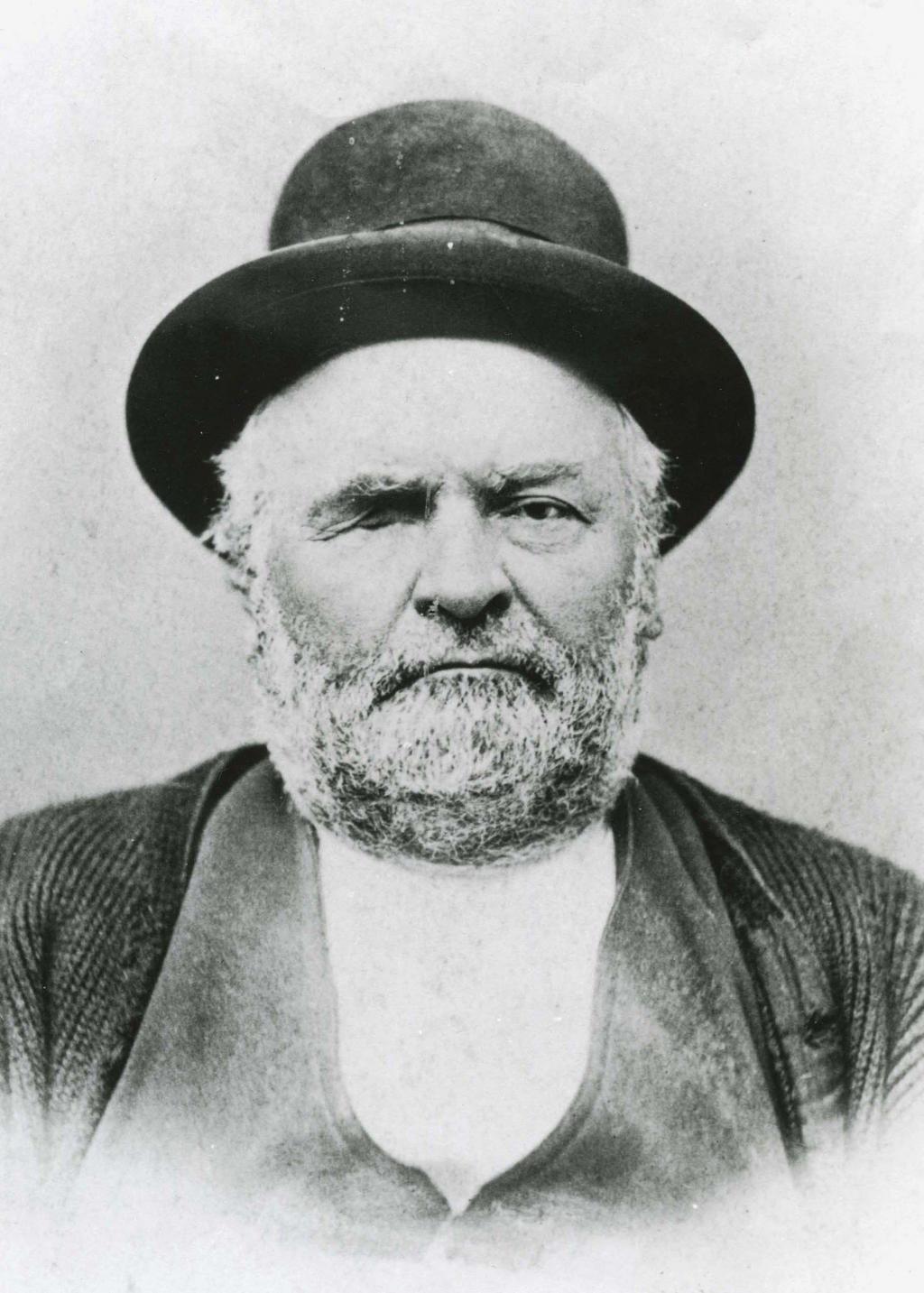
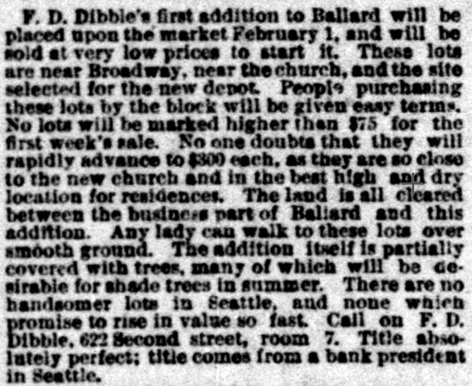
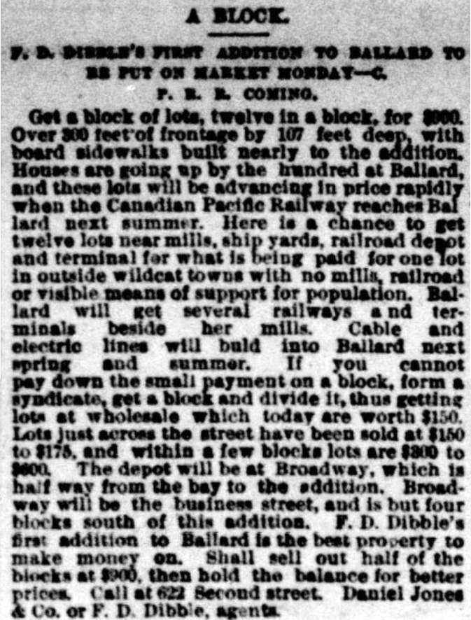
This street was created in 1890 as part of F.D. Dibble’s First Addition to Ballard, which had just incorporated as a city that year, and would be annexed to Seattle 17 years later. It would, therefore, seem to be named after F.D. Dibble. But who was he? And who was J. Albert Jackson, who filed the plat?
Jackson first. The December 2, 1912, issue of The Sacramento Union refers to him as former vice president of the Washington-Alaska Bank of Nevada (based in Fairbanks). He was charged with falsifying the failed bank’s books and aiding and abetting its receiver, Frank W. Hawkins, in embezzlement. So much for his good name, which was used in one of the advertisements for the addition: “Title absolutely perfect; title comes from a bank president in Seattle.”
Advertisements for F.D. Dibble’s First Addition to Ballard in the Seattle Post-Intelligencer, January 27 and 31, 1890. “These lots are near Broadway [NW Market Street], near the church, and the site selected for the new depot [37th Place NW south of NW 57th Street].” “Houses are going up by the hundred at Ballard, and these lots will be advancing in price rapidly when the Canadian Pacific Railway reaches Ballard next summer. Here is a chance to get twelve lots near mills, ship yards, railroad depot and terminal for what is being paid for one lot in outside wildcat towns with no mills, railroad or visible means of support for population.”
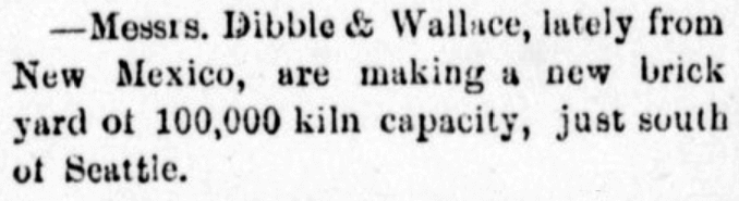
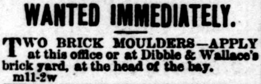
I was able to find out even less about F.D. Dibble. He appears to have been associated with Daniel Jones & Co., who were involved in the development of Mount Baker Park (see Hunter Boulevard S for more on Jones). But that’s it. I was able to find two mentions of Dibble & Wallace, a brick manufacturing company, which opened in 1882, but no first names of either proprietor. Dibble may have been F.D., or a relative — it’s impossible to say.
Advertisements for the brick manufacturing company Dibble & Wallace in the Northwest Enterprise (Anacortes), April 8, and the Seattle Post-Intelligencer, May 21, 1882
I also came across a book, Prairie Poems and Others, written by an F.D. Dibble and published in 1900. There is no biographical information included, but this Dibble plainly had been to Washington: among the many poems are “Lake Pend d’Oreille, Washington,” “Mt. Rainier,” and “Rainy Days in Seattle.” Could this have been the real estate man? Again — impossible to say.
We must leave it at this, then: Dibble Avenue NW was named for F.D. Dibble… full stop.
Today, Dibble Avenue NW begins at NW 65th Street and goes 1½ miles north to NW 95th Street. It begins again on the other side of Holman Road NW at NW 97th Street and goes ⅓ of a mile north to NW 105th Street.
Born and raised in Seattle, Benjamin Donguk Lukoff had his interest in local history kindled at the age of six, when his father bought him settler granddaughter Sophie Frye Bass’s Pig-Tail Days in Old Seattle at the gift shop of the Museum of History and Industry. He studied English, Russian, and linguistics at the University of Washington, and went on to earn his master’s in English linguistics from University College London. His book of rephotography, Seattle Then and Now, was published in 2010. An updated version came out in 2015.
According to the Mount Baker Historic Context Statement, “Since Mount Baker Park was designed to be an exclusive single-family residential community, one of the early concerns of the Mount Baker Park Improvement Club was related to social issues, and what became known as the ‘Restrictions Committee’”:
[This committee] was involved in enforcing the restrictions contained in the deeds regarding single family housing only and the restrictive covenants that prevented non-whites from purchasing property in the area. The club passed a resolution stating that the club was against using any lot for clubs, schools, boarding or lodging houses, churches, charitable or religious societies or orders or for any other purpose than strictly detached family residences.
Discrimination in Mount Baker continued for decades, though it did eventually become a became a “locus for pushback against racial injustice.” The Seattle Star headlines below illustrate both the discrimination and early examples of resistance:
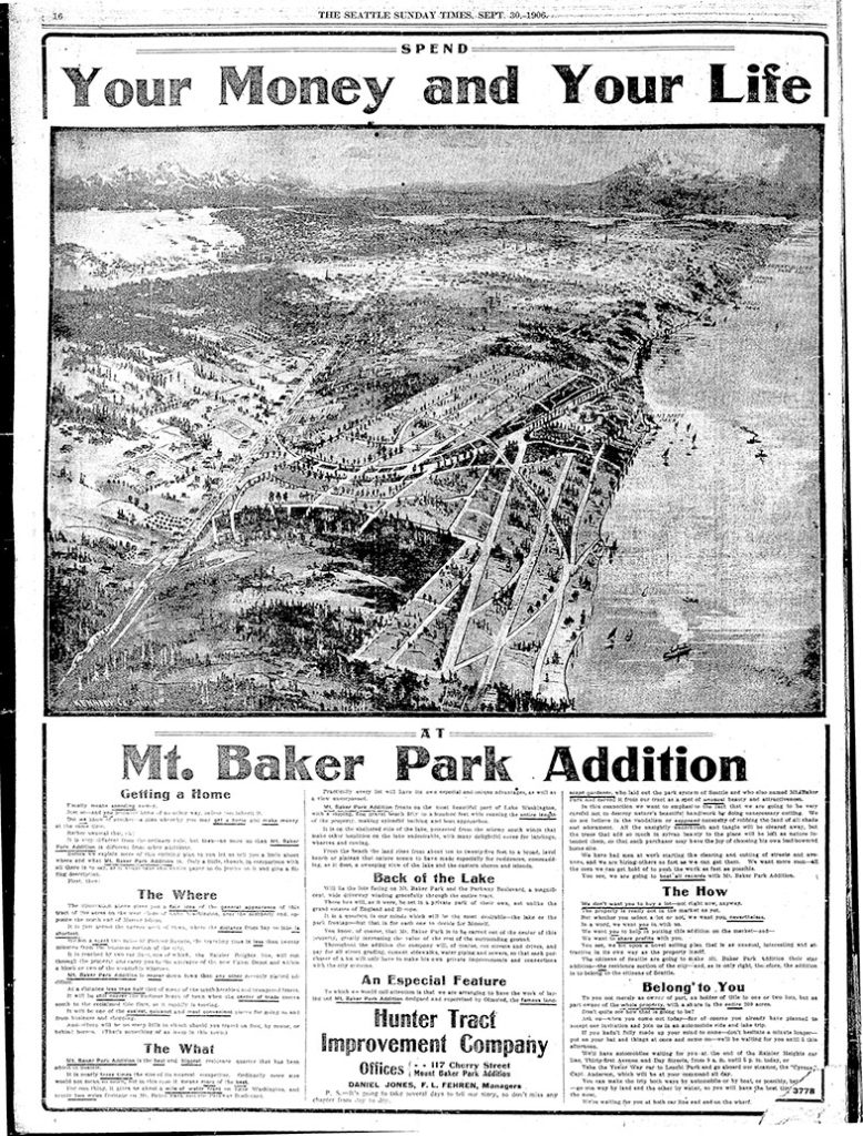
The first article, ‘Hunter Tract lots are not for colored people,’ appeared on April 2, 1909. An excerpt:
The owners of the Hunter tract, a fashionable residence addition overlooking Lake Washington, don’t intend to permit any colored people to build homes on their property.… F.H. Stone and Susie B. Stone are colored.… Arrangements were made by the Stones to erect a dwelling upon [their] lot. According to the officers of the investment company, it was then that they first discovered that the Stones were colored people.… [They] contended that if the Stones were permitted to build their dwelling and to occupy it, values of surrounding property would be decreased and a pecuniary hardship would therefore be worked upon the owners of the Hunter tract.
The case went to trial before Judge John F. Main. ‘No color line is drawn in Seattle’ appeared on November 6, 1909, the day after he rendered his decision:
The incident of color or race cannot of itself annul the terms of a contract, and there is no Mason and Dixon’s line in the residence district of Seattle.… Judge Main held, in substance, that no negro, because of his color, is legally barred from acquiring property and holding the same in the most exclusive community or from residing next door to his white neighbor.
Meanwhile, another related case was working its way through the courts. ‘Negro given right to live in Mt. Baker’ read the headline on February 1, 1910:
David Cole, a well-to-do negro… bought [a lot] from the Hunter Tract company. The officials of the company did not know that he was a negro until he came to the office to get his deed. Daniel Jones, agent for the firm, tried to buy him off… Cole insisted on having his deed and Jones refused to give it to him. Cole took the case to court and Judge Frater this morning decided that Jones must give Cole the deed. Jones immediately gave notice of appeal. Jones contended that Cole’s presence in the tract would lower property values from 40 to 50 per cent but Judge Frater held that a contract is a contract.
Born and raised in Seattle, Benjamin Donguk Lukoff had his interest in local history kindled at the age of six, when his father bought him settler granddaughter Sophie Frye Bass’s Pig-Tail Days in Old Seattle at the gift shop of the Museum of History and Industry. He studied English, Russian, and linguistics at the University of Washington, and went on to earn his master’s in English linguistics from University College London. His book of rephotography, Seattle Then and Now, was published in 2010. An updated version came out in 2015.
S Mount Baker Boulevard, intended to connect Lake Washington Boulevard to Beacon Hill, begins at S McClellan Street and Lake Park Drive S (the latter of which leads to Lake Washington Boulevard) and goes just over ½ a mile west to Rainier Avenue S and Martin Luther King Jr. Way S. West of the intersection, the boulevard continues as S Winthrop Street, which connects to Cheasty Boulevard S leading up Beacon Hill.
Born and raised in Seattle, Benjamin Donguk Lukoff had his interest in local history kindled at the age of six, when his father bought him settler granddaughter Sophie Frye Bass’s Pig-Tail Days in Old Seattle at the gift shop of the Museum of History and Industry. He studied English, Russian, and linguistics at the University of Washington, and went on to earn his master’s in English linguistics from University College London. His book of rephotography, Seattle Then and Now, was published in 2010. An updated version came out in 2015.
This road, and the park through which it runs, Schmitz Park (or Schmitz Preserve Park), was named for German immmigrants Ferdinand Schmitz (1860–1942) and his wife, Emma Althoff Schmitz (1864–1959). Ferdinand was a banker, city councilman, and parks commissioner. He and Emma donated land — mostly, though not entirely, old-growth forest — to the city in 1908, forming the core (just over 55%) of the present park.
The Schmitzes had four children: Dietrich, Henry, Emma Henrietta, and Ferdinand Jr. A banker, Dietrich (1890–1969) became president of Washington Mutual in 1934 and retired as chairman of the board two years before his death. He was also a member of the Seattle School Board from 1928 (or 1930; sources differ) to 1961. Henry (1892–1965) was president of the University of Washington from 1952 to 1958. Schmitz Hall, the university’s administration building on NE Campus Parkway, was named in his memory in 1970.
The roadway was originally envisioned as a continuation of the West Seattle Parkway, never realized, which would have connected Alki Beach to Lake Washington via a series of parkways. The built section is instead a short road that provided the only automobile entry to Schmitz Park, extending through an allée of trees and terminating at a pergola and shelterhouse.
Map of proposed West Seattle Parkway, cropped from a 1928 map showing both existing (red) and proposed (red hatched) park features. Schmitz Park and Boulevard are at upper left. Courtesy of the Seattle Municipal Archives, Identifier 2333.
The portion between 59th Avenue SW and 58th Avenue SW in front of Alki Elementary School having been closed in 1949, Schmitz Boulevard today begins at 58th Avenue SW and SW Stevens Street and goes not quite half a mile east, then southeast, then north, to SW Admiral Way and SW Stevens Street. It is closed to automobile traffic.
Emma Schmitz
Ferdinand Schmitz
Emma and Ferdinand Schmitz. Her photo is from the December 24, 1959, issue of the Seattle Post-Intelligencer (she had died December 23); his is from the August 23, 1942, issue of The Seattle Times (he had died August 21).
Born and raised in Seattle, Benjamin Donguk Lukoff had his interest in local history kindled at the age of six, when his father bought him settler granddaughter Sophie Frye Bass’s Pig-Tail Days in Old Seattle at the gift shop of the Museum of History and Industry. He studied English, Russian, and linguistics at the University of Washington, and went on to earn his master’s in English linguistics from University College London. His book of rephotography, Seattle Then and Now, was published in 2010. An updated version came out in 2015.
Puget Boulevard is a curious street, for a number of reasons:
The paved portions are only a few blocks long — hardly comparable to, say, Lake Washington Boulevard or Magnolia Boulevard;
Both east–west and north–south portions are called Puget Boulevard SW, contrary to the rule that directional designations precede street names for east–west streets (this is why Lake Washington Boulevard E becomes E Lake Washington Boulevard when it curves west on its approach to Montlake Boulevard E);
Despite its name, it has no view of Puget Sound, sitting as it does in the Longfellow Creek valley in the Delridge neighborhood of West Seattle;
And, as it turns out, it isn’t even named for Puget Sound, as might be expected, but rather for the Puget Mill Company (later part of Pope & Talbot and today part of Rayonier).
“A rugged tract of logged-off land south of Pigeon Point and Youngstown in the large unplatted area” (20.5 acres — this became Puget Park); and
“A strip of land 160 feet in width extending from Sixteenth Avenue Southwest and Edmonds Street (sic) to Thirty-fifth Avenue Southwest and Genessee Street, a distance of 8,500 feet, and comprising an area of about fifteen acres for parkway purposes. Under the conditions of this gift improvement work must be undertaken within five years. This acquisition forms an important link in the contemplated boulevard to West Seattle.”
This strip is today’s Puget Boulevard SW. Two things become apparent when looking at the King County Parcel Viewer map of West Seattle:
Map of Puget Boulevard, from King County Parcel Viewer
Once past the present site of West Seattle Stadium, the “contemplated boulevard to West Seattle” was to have run, as the Friends of Seattle’s Olmsted Parks puts it,
[Across] California Avenue a few blocks north of [the] present-day Alaska Junction, at that time part of the “Boston Subdivision.” It would have then headed northwest and down a ravine, eventually turning southwest to terminate at Alki Point.
Map of proposed West Seattle Parkway, cropped from a 1928 map showing both existing (red) and proposed (red hatched) park features. Puget Park and Boulevard are at lower right. Courtesy of the Seattle Municipal Archives, Identifier 2333.
Returning to the question of the name — the Puget Mill Company was, of course, named after Puget Sound, which itself was named in 1792 by Captain George Vancouver of HMS Discovery for Lieutenant Peter Puget (1765–1822).
Today, the paved portion of Puget Boulevard SW begins at 23rd Avenue SW, about 1⁄10 of a mile north of SW Hudson Street, and goes ⅕ of a mile south to a dead end. After a very short section — not more than 150 feet long — east of Delridge Way SW, which serves as a driveway for a complex of townhouses, it resumes west of a foot path off Delridge and goes about 1⁄10 of a mile west to 26th Avenue SW. Along this stretch, there are houses to the north and the Delridge P-Patch and Puget Boulevard Commons to the south.
Born and raised in Seattle, Benjamin Donguk Lukoff had his interest in local history kindled at the age of six, when his father bought him settler granddaughter Sophie Frye Bass’s Pig-Tail Days in Old Seattle at the gift shop of the Museum of History and Industry. He studied English, Russian, and linguistics at the University of Washington, and went on to earn his master’s in English linguistics from University College London. His book of rephotography, Seattle Then and Now, was published in 2010. An updated version came out in 2015.
According to an article in the October 29, 1905, issue of the Seattle Post-Intelligencer, Robert bought the tract from H.M. Haller for $9,000. According to the obituary reproduced below, he was a “lumberman, contractor, and real estate man,” originally from Wisconsin, who had come to Seattle that very year, though he had been living in Washington since 1900.
Obituary of Robert James Patten, The Seattle Times, October 6, 1919
Patten Place W begins at W Armour Street just north of Bayview Playground and goes about 420 feet north to a dead end, though the undeveloped right-of-way continues on for about 250 feet more to the likewise undeveloped right-of-way of W Barrett Street.
Born and raised in Seattle, Benjamin Donguk Lukoff had his interest in local history kindled at the age of six, when his father bought him settler granddaughter Sophie Frye Bass’s Pig-Tail Days in Old Seattle at the gift shop of the Museum of History and Industry. He studied English, Russian, and linguistics at the University of Washington, and went on to earn his master’s in English linguistics from University College London. His book of rephotography, Seattle Then and Now, was published in 2010. An updated version came out in 2015.


