This street is named after William Harvey “Uncle Joe” Surber (1834–1923), who came to Seattle from Indiana in 1859, having spent time in Missouri, California, and British Columbia along the way. Valarie Bunn tells his story in “From Yesler to Wedgwood,” and his Find a Grave page reproduces his biography from Clarence Bagley’s History of Seattle from the Earliest Settlement to the Present Time. In 1861, he established a homestead in what is now Laurelhurst, on what was then the east shore of Union Bay but is now Yesler Swamp. He was appointed the first sheriff of King County in 1866.
Originally 39th Avenue NE in the plat of Belvoir, an Addition to the City of Seattle, filed by his executor in 1926, it and E 37th Street became Surber Drive in 1939. Today, Surber Drive NE begins at NE 41st Street and goes around 700 feet to NE 38th Street, where it becomes NE Surber Drive and goes nearly 1,000 feet to 42nd Avenue NE.
Born and raised in Seattle, Benjamin Donguk Lukoff had his interest in local history kindled at the age of six, when his father bought him settler granddaughter Sophie Frye Bass’s Pig-Tail Days in Old Seattle at the gift shop of the Museum of History and Industry. He studied English, Russian, and linguistics at the University of Washington, and went on to earn his master’s in English linguistics from University College London. His book of rephotography, Seattle Then and Now, was published in 2010. An updated version came out in 2015.
This street is named for James William Clise (1855–1938), who is said to have come to Seattle with his wife, Anna Herr Clise (1866–1936), on June 7, 1889, the day after the Great Seattle Fire. Anna is best known for founding Children’s Orthopedic Hospital (today known as Seattle Children’s) in 1907. In 1890, James founded what is now Clise Properties. Over the years he, among other things:
Helped the University of Washington relocate from Downtown to its current campus
Helped establish Fort Lawton (now Discovery Park) in Magnolia
Helped Lyman Smith build the Smith Tower
Helped kickstart the agricultural industry in Eastern Washington
Founded the Washington Trust Company, which after a series of mergers is now part of Bank of America
Helped organize the Alaska–Yukon–Pacific Exposition
Helped fund the construction of the Lake Washington Ship Canal and Ballard Locks
Clise Place W originates in the 1928 plat of Magnolia View Addition to the City of Seattle, filed by the Clise Investment Company. It originally only went from W Howe Street at Magnolia Boulevard W to W Crockett Street, but the name replaced that of Rucker Place between there and W Lynn Street and 33rd Avenue W, giving it a total length of just under ¼ mile.
Born and raised in Seattle, Benjamin Donguk Lukoff had his interest in local history kindled at the age of six, when his father bought him settler granddaughter Sophie Frye Bass’s Pig-Tail Days in Old Seattle at the gift shop of the Museum of History and Industry. He studied English, Russian, and linguistics at the University of Washington, and went on to earn his master’s in English linguistics from University College London. His book of rephotography, Seattle Then and Now, was published in 2010. An updated version came out in 2015.
In the early 1870s, the Denny and Mercer families gradually began to systematically subdivide their large land holdings on the south and east slopes of Queen Anne Hill. When a severe windstorm blew down thousands of trees in the north district in 1875, views opened up and land seekers turned their attentions beyond Belltown. Real estate speculators new to the territory arrived and began to buy up property on the crest of Queen Anne Hill. Some of these speculators also became developers, such as George Kinnear, or builder-developers, such as Isaac Bigelow.
Bigelow Avenue N forms a major part of Queen Anne Boulevard, the scenic loop atop Queen Anne Hill. It begins at 2nd Avenue N and Prospect Street and goes 9⁄10 of a mile to Wheeler Street between 4th Avenue N and 5th Avenue N.
Part of the street is lined with chestnut trees — not horse chestnuts, but the edible variety, specifically the Chinese chestnut, Castanea mollissima, according to the city’s records. My family (my mother was Korean) never foraged here, though we have done so elsewhere in the area, both for chestnuts and fiddlehead ferns. But plenty of others have, and continue to do so, as these articles show:
It should be noted that since Bigelow Avenue N is part of Queen Anne Boulevard, the trees belong to the parks department, not to the neighbors. As with similar park boulevards in town, neighbors’ yards often encroach on the public right-of-way.
Born and raised in Seattle, Benjamin Donguk Lukoff had his interest in local history kindled at the age of six, when his father bought him settler granddaughter Sophie Frye Bass’s Pig-Tail Days in Old Seattle at the gift shop of the Museum of History and Industry. He studied English, Russian, and linguistics at the University of Washington, and went on to earn his master’s in English linguistics from University College London. His book of rephotography, Seattle Then and Now, was published in 2010. An updated version came out in 2015.
This street was named for Alonzo Hamblet (1863–1937), son of Eli (1820–1905) and Mary Booth Hamblet (1840–1905), namesake of Mary Avenue NW. According to an article in the November 19, 1937 issue of The Seattle Times, the Hamblets had their homestead where Ballard High School is today. Alonzo was one of the men behind the West Coast Improvement Company that developed Ballard (then known as Gilman Park).
Alonzo Avenue NW begins at NW 67th Street just north of the high school and goes ⅖ of a mile to NW 75th Street.
Born and raised in Seattle, Benjamin Donguk Lukoff had his interest in local history kindled at the age of six, when his father bought him settler granddaughter Sophie Frye Bass’s Pig-Tail Days in Old Seattle at the gift shop of the Museum of History and Industry. He studied English, Russian, and linguistics at the University of Washington, and went on to earn his master’s in English linguistics from University College London. His book of rephotography, Seattle Then and Now, was published in 2010. An updated version came out in 2015.
“But,” you might say, “if he developed Fremont, why is W Blewett Way in Queen Anne?”
As you can see in the map below, and in this plat he filed in 1888 of what is now Fremont and North Queen Anne before the Fremont Cut was dug, Ewing and Blewett Streets used to be part of both neighborhods. When they became separated, the names were left alone on the Queen Anne side; in Fremont, they were changed as follows: Kilbourne to N 36th Street, Blewett to N 35th Street, and Ewing to N 34th Street.
Portion of 1912 Baist Atlas showing Fremont Cut
It’s not quite that simple, though — Blewett never reached quite as far as 13th Avenue W. What appears to have happened is that a name was needed when what is now W Blewett Way was created in 1907, and because the street to the south was still Ewing, Blewett presented itself as a natural choice. The rest of Blewett south of the canal was vacated over the years, so this is all that’s left of the name.
Today, W Blewett Way begins at the north end of 13th Avenue W and goes east just about ⅒ of a mile before it becomes a private driveway.
Born and raised in Seattle, Benjamin Donguk Lukoff had his interest in local history kindled at the age of six, when his father bought him settler granddaughter Sophie Frye Bass’s Pig-Tail Days in Old Seattle at the gift shop of the Museum of History and Industry. He studied English, Russian, and linguistics at the University of Washington, and went on to earn his master’s in English linguistics from University College London. His book of rephotography, Seattle Then and Now, was published in 2010. An updated version came out in 2015.
I wasn’t sure whether to label Van Buren Avenue a “paper street” or not. Unlike W Semple Street and Albert Place W, part of the right-of-way has actually been improved (see below). However, like those two streets, it is not signed; and unlike Semple, there are no buildings with Van Buren Avenue addresses. (There are two houses on the street, but one has a W Prospect Street address; the other, an Elliott Avenue W address.)
The right-of-way stretches from just southeast of W Prospect Street, northeast of Elliott Avenue W, to where the Magnolia Bridge onramp turns west at W Garfield Street. The first 350 or so feet are drivable. There is also a foot trail through the Southwest Queen Anne Greenbelt in the right-of-way, beginning at the east end of W Lee Street and heading southeast. Lastly, just under 600 feet of the Magnolia Bridge onramp is located in the right-of-way. It could conceivably be signed Van Buren Avenue W instead of W Galer Street Flyover, but this is not the case.
Born and raised in Seattle, Benjamin Donguk Lukoff had his interest in local history kindled at the age of six, when his father bought him settler granddaughter Sophie Frye Bass’s Pig-Tail Days in Old Seattle at the gift shop of the Museum of History and Industry. He studied English, Russian, and linguistics at the University of Washington, and went on to earn his master’s in English linguistics from University College London. His book of rephotography, Seattle Then and Now, was published in 2010. An updated version came out in 2015.
In 1907, Anna Sophia Brygger (1852–1940) (NW Brygger Place, Brygger Drive W) filed the plat of Lawton Heights in Magnolia. Because a good portion of it was taken up by what is now known as Kiwanis Ravine, many of the streets were only partially built (Fort Place, 35th Avenue W, 34th Avenue W, Brygger Drive) or never built at all (Northview Place, Albert Street [Alberta is a typo], Byers Place). For some reason, they have never been vacated, making them all paper streets, and unlike W Semple Street, they don’t even have any buildings with addresses.
Brygger had seven children, one of whom was named Albert (1887–1977). According to Paul Dorpat, he was at one point president of Peoples National Bank (now part of U.S. Bank). It seems a fair bet that she named Albert Street after him.
Map of Lawton Heights Addition, Magnolia, 1912 Baist Atlas
Born and raised in Seattle, Benjamin Donguk Lukoff had his interest in local history kindled at the age of six, when his father bought him settler granddaughter Sophie Frye Bass’s Pig-Tail Days in Old Seattle at the gift shop of the Museum of History and Industry. He studied English, Russian, and linguistics at the University of Washington, and went on to earn his master’s in English linguistics from University College London. His book of rephotography, Seattle Then and Now, was published in 2010. An updated version came out in 2015.
Fremont Avenue N begins at the north end of the Fremont Bridge (making it a continuation, in a sense, of both Dexter Avenue N and Westlake Avenue N) and goes 1⅙ miles north to N 50th Street and Woodland Park Zoo. It resumes north of the zoo at N 59th Street and goes 3½ miles to N 130th Street and Bitter Lake Playfield, a short portion of the block between N 61st Street and N 62nd Street being stairway. North of the lake, there are two short stretches: one going a couple blocks south from N 143rd Street, adjoining the Bitter Lake Reservoir, and another going a block south from the city limits at N 145th Street.
As with many North Seattle avenues, the Fremont name continues on into Shoreline. Its northernmost appearance is at the King–Snohomish county line at N 205th Street.
Born and raised in Seattle, Benjamin Donguk Lukoff had his interest in local history kindled at the age of six, when his father bought him settler granddaughter Sophie Frye Bass’s Pig-Tail Days in Old Seattle at the gift shop of the Museum of History and Industry. He studied English, Russian, and linguistics at the University of Washington, and went on to earn his master’s in English linguistics from University College London. His book of rephotography, Seattle Then and Now, was published in 2010. An updated version came out in 2015.
42nd St, 50th St, 1st Ave, and 5th Ave are the boundaries of the 1889 Harrison Heights Addition to the City of Seattle (annexed in 1891). J.A. Gould and Anna L. Gould, the owners, had the civil engineers draw a simple box around their property and didn’t bother to make their streets match those adjacent. But when the streets were renamed and woven together in the 1890s, 1st and 2nd Avenues bent west at 42nd while Latona, 4th and 5th bent east. Space for an extra road was left in between: Thackeray Place.
Their Dickens Street became 1st Avenue NE; Scott Street, 2nd Avenue NE; Cooper Street, Latona Avenue NE; Milton Street, 4th Avenue NE; and Kingsley Street, 5th Avenue NE. Thackery Street, as it was originally named, had no corresponding street in the already existing grid. (Why it was left alone instead of being renamed something like 2nd Place NE is unclear.) As Rob points out, these names are almost certainly those of the writers Charles Dickens, Walter Scott, James Fenimore Cooper, John Milton, Charles Kingsley… and William Makepeace Thackeray.
Born and raised in Seattle, Benjamin Donguk Lukoff had his interest in local history kindled at the age of six, when his father bought him settler granddaughter Sophie Frye Bass’s Pig-Tail Days in Old Seattle at the gift shop of the Museum of History and Industry. He studied English, Russian, and linguistics at the University of Washington, and went on to earn his master’s in English linguistics from University College London. His book of rephotography, Seattle Then and Now, was published in 2010. An updated version came out in 2015.
This street was named by and for John Gill Matthews (1864–1937), who, with his wife and son, filed the plat of J.G. Matthews’ Lake Washington Addition, Division One, in 1930. In an extensive article on her blog, Wedgwood in Seattle History, Valarie Bunn tells his story, from his origins in Barbourville, Kentucky, during the Civil War, to his death in 1937, and beyond. For some reason, he, his wife, and three children moved to Seattle in 1910, when he was 45 and already had a well-established legal career in Kentucky. Once in Seattle, he became involved in coal, timber, and automobiles in addition to the law. It appears he and his wife separated around 1924, though they never divorced.
Fortunately for the citizens of Seattle, the Matthews family held onto the portion of their land on Lake Washington, and never developed it either before or after John Matthews’s death. Amy Matthews, who inherited the property, died in 1950, and the city was able to purchase the land for $70,000 the next year to create Matthews Beach Park, the city’s largest bathing beach. As Valarie explains:
The Matthews family was so willing to share the use of their property with neighbors that the area first began to be known as Matthews Beach in the 1920s while still under private ownership. The first appeal to the City of Seattle to buy the property was in 1928. Ironically the Parks Department vigorously opposed the purchase due to differences of opinion between those who wanted to acquire more parks in Seattle, and those who wanted monies to be allocated to maintenance of already-existing parks. Since the City of Seattle was not able to go ahead with purchase of the Matthews Beach property in 1928, the Matthews family could easily have redeveloped or sold the site at any time. It is a tribute to their stewardship and the efforts of north Seattle community clubs and activists that finally in 1951, the City purchased Matthews Beach.
John G. Matthews, from his obituary in the the November 16, 1937, issue of The Seattle Times
Matthews Avenue NE begins and ends at Sand Point Way NE, going about ¼ mile in a semicircle from just south of Matthews Place NE to just north of NE 93rd Street.
Born and raised in Seattle, Benjamin Donguk Lukoff had his interest in local history kindled at the age of six, when his father bought him settler granddaughter Sophie Frye Bass’s Pig-Tail Days in Old Seattle at the gift shop of the Museum of History and Industry. He studied English, Russian, and linguistics at the University of Washington, and went on to earn his master’s in English linguistics from University College London. His book of rephotography, Seattle Then and Now, was published in 2010. An updated version came out in 2015.
Martin Van Buren Stacy, from his obituary in the April 18, 1901, Seattle Post-Intelligencer. He had died at Green River Hot Springs the previous week of “apoplexy.”
S Stacy Street begins at Airport Way S and goes ⅕ of a mile west to 6th Avenue S. There is a block-long segment between 4th Avenue S and 3rd Avenue S, and then on the other side of the former Stacy Yard a two-block–long segment from Occidental Avenue S to Utah Avenue S and the world headquarters of Starbucks.
Born and raised in Seattle, Benjamin Donguk Lukoff had his interest in local history kindled at the age of six, when his father bought him settler granddaughter Sophie Frye Bass’s Pig-Tail Days in Old Seattle at the gift shop of the Museum of History and Industry. He studied English, Russian, and linguistics at the University of Washington, and went on to earn his master’s in English linguistics from University College London. His book of rephotography, Seattle Then and Now, was published in 2010. An updated version came out in 2015.
This street was named for Walter Graham (1828–1919), who came to Seattle in 1853. Three years later, he married Eliza Mercer, second daughter of Thomas Mercer (Mercer Street, Mercer Island), though she unfortunately died six years later. With his third wife, Elizabeth Crammond (or Crommon), he had a daughter, Nellie, who later married David Thomas Denny II, son of early settler David Thomas Denny (Denny Way). Graham’s brother, David, came to Seattle four years after his brother, and was one of the city’s first schoolteachers. He ended up marrying Eliza Mercer’s sister, Susannah.
Graham sold some of his southeast Seattle land in 1865 to Everett Smith, who filed the plat of Brighton Beach in 1890 on which what was then Graham Avenue appeared. He once owned what is today Seward Park on Bailey Peninsula, which was previously known as Graham’s Peninsula.
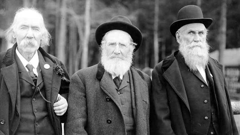
He was present at the Battle of Seattle in 1856, and is pictured below with fellow survivors Ira Woodin and Carson D. Boren (Boren Avenue).
Ira Woodin, Carson Boren, and Walter Graham at Alki Point, November 3, 1905
S Graham Street begins in the east at Wilson Avenue S and goes 2⅒ miles west to Swift Avenue S and 20th Avenue S, just east of Interstate 5. After a short segment between Corgiat Drive S and 16th Avenue S just west of the freeway, it next appears in West Seattle. Betwen 16th Avenue SW and 22nd Avenue SW, it alternates between roadway, stairway, and pathway, and there is a similar situation between 25th Avenue SW at Delridge Way SW and High Point Drive SW at Bataan Park. SW Graham Street begins again at High Point Drive SW and SW Raymond Street and goes 1¼ miles to its end at 50th Avenue SW,
Born and raised in Seattle, Benjamin Donguk Lukoff had his interest in local history kindled at the age of six, when his father bought him settler granddaughter Sophie Frye Bass’s Pig-Tail Days in Old Seattle at the gift shop of the Museum of History and Industry. He studied English, Russian, and linguistics at the University of Washington, and went on to earn his master’s in English linguistics from University College London. His book of rephotography, Seattle Then and Now, was published in 2010. An updated version came out in 2015.
This street is named for David Thomas Denny (1832–1903). He was one of the members of the Denny Party that landed at Alki Point in 1851, led by his older brother, Arthur Armstrong Denny (1822–1899). In 1853, he married his sister-in-law, Louisa Boren (1827–1916). (Louisa’s older sister, Mary Ann Boren [1822–1910], had married Arthur in 1843. She, Louisa, and their brother, Carson Dobbins Boren [1824–1912], were also part of the Denny Party).
The Dennys settled on land in what is now Lower Queen Anne, living in a series of houses in the area until they went bankrupt in the Panic of 1893 and had to leave their mansion for their summer cottage at Licton Springs, where they lived with their oldest child, Emily Inez Denny (1853–1918), until they died.
Denny Park is named for the couple, which had given the land to the city as its first cemetery in 1861; the bodies were moved to the Washelli Cemetery on Capitol Hill in the 1880s, at which time the original cemetery was converted to a park, likewise the city’s first. (Just a few years later, Washelli was also converted to a park, initially known as Lake View Park, then City Park, and finally, in 1901, Volunteer Park. The Dennys’ private burial ground near the no-longer-existent Oak Lake eventually became the Oaklake Cemetery, which, after being sold by their son Victor in 1914, was renamed Washelli after the original cemetery of that name; Evergreen Cemetery, across Aurora Avenue N from Washelli, bought the latter in 1922, and the combined cemetery took its current name, Evergreen Washelli, in 1962.)
David Denny was active in government. According to HistoryLink.org, he was:
…Probate judge, King County commissioner, Seattle City Council member, a director of the Seattle School District, and regent of the Territorial University of Washington.… Denny was an ardent advocate of woman suffrage and helped lead the movement that in the 1880s won Washington women the right to vote. He opposed the expulsion of Chinese immigrants in 1886, which antagonized local nativists.
Denny was also involved in the development of a number of Seattle neighborhoods; in addition to Queen Anne, he developed tracts in South Lake Union, Capitol Hill, and Ravenna, and founded the Rainier Power and Railway Company, which ran the first streetcar from Downtown (Pioneer Square) to the University District (Ravenna Park).
David T. Denny, 1890. Courtesy of the Seattle Municipal Archives, Identifier 175313.
Denny Way — originally named Depot Street by Denny after a proposed train station that never materialized — begins as a shoreline street end on Elliott Bay, indistinguishable from the surrounding Myrtle Edwards Park. On the other side of the BNSF Railway tracks, W Denny Way begins as a pathway and stairway from Elliott Avenue to Western Avenue. From here, it is a major arterial, becoming Denny Way as it crosses Queen Anne Avenue N (originally named Temperance Street by Denny), and going 2½ miles east to E Madison Street and 22nd Avenue. (It becomes a neighborhood street on crossing E Olive Way, and the block between Broadway and 10th Avenue E was renamed E Barbara Bailey Way in 2019). E Denny Way begins again at E Madison Street and 23rd Avenue and goes ⅘ of a mile east to Madrona Place E and 38th Avenue, where it turns into Madrona Drive.
Denny Way, which becomes E Denny Way east of Eastlake Avenue E, also divides five of the city’s directional designation zones from each other, similarly to Yesler Way. North of Denny but west of Queen Anne Avenue N, east–west streets carry the W prefix and north–south avenues carry the suffix W. North of Denny between Queen Anne Avenue N and Eastlake Avenue E, east–west streets carry no prefix and north–south avenues carry the suffix N. North of Denny east of Eastlake Avenue E, east–west streets carry the E prefix and north–south avenues carry the suffix E. South of Denny but west of a line that includes Melrose Avenue, Minor Avenue, E Union Street, and Broadway, neither east–west streets nor north–south avenues carry a prefix or suffix. And south of Denny but east of that line, east–west streets carry the E prefix and north–south avenues carry no suffix.
Born and raised in Seattle, Benjamin Donguk Lukoff had his interest in local history kindled at the age of six, when his father bought him settler granddaughter Sophie Frye Bass’s Pig-Tail Days in Old Seattle at the gift shop of the Museum of History and Industry. He studied English, Russian, and linguistics at the University of Washington, and went on to earn his master’s in English linguistics from University College London. His book of rephotography, Seattle Then and Now, was published in 2010. An updated version came out in 2015.
This street is named after Henry Leiter Yesler (1810–1892). Originally from Leitersburg, Maryland, which was founded by his great-grandfather, and living in Massillon, Ohio, before coming west, he moved to Seattle from Portland, Oregon, in 1852. As John Caldbick writes for HistoryLink.org:
…[Yesler] quickly established himself as the most important resident of the rain-swept little spot that would soon become Seattle. He had the first steam-powered sawmill on Puget Sound up and running within months, and for several years he employed almost every male settler in Seattle and a considerable number of Native Americans. His mill was early Seattle’s only industry, and without it the town’s development would have been greatly delayed.
Carson Dobbins Boren and David Swinson “Doc” Maynard had already claimed land on Elliott Bay either side of what is today Pioneer Square, but they gave him part of their claims so he could access the water from the claim he made farther up First Hill. Yesler’s mill was built at the foot of what is now Yesler Way but was originally Mill Street, also known as Skid Road — and yes, Seattle may be where the term originated, referring to a neighborhood largely inhabited by the “down and out.”
Yesler was also King County auditor in 1852, and Seattle mayor from 1874 to 1875 and 1885 to 1886.
Yesler had two children: a son, Henry George Yesler (1845–1859), by his wife, Sarah Burgert Yesler (1822–1887); and a daughter, Julia Benson Intermela (1855–1907). Her mother wasn’t Sarah, who didn’t come to Seattle until 1858, but rather a Duwamish woman named Susan, daughter of Salmon Bay Curley (Su-quardle), who had worked at Yesler’s mill. When Sarah finally joined her husband, he sent Susan and Julia to live with Jeremiah S. Benson, a cook at the mill. In the 1870 territorial census, Julia is listed as living with the Bensons, but the next year she is listed as a HB (“half-breed”) house servant for the Yeslers. Unlike Rebecca Lena Graham, who successfully sued the relatives of Franklin Matthias to be recognized as his rightful heir, Julia inherited nothing when her father died in 1892. Even so,
…The settlement of Henry Yesler’s estate was an imbroglio of epic proportions. It pitted Minnie Gagle Yesler [a younger cousin whom he married a few years before his death] and her mother against James Lowman [his nephew] and municipal authorities, who believed that Yesler had made a will that left most of his fortune, by then worth more than $1,000,000, to the city, hoping thereby to cement his reputation as the “Father of Seattle.”
Yesler is also quoted as anticipating “Strange Fruit” by 55 years… though it’s by no means a sentiment Abel Meeropol or Billie Holiday would have shared. In January 1882, a mob lynched James Sullivan, William Howard, and Benjamin Paynes between two of his maple trees. Harper’s Weekly reported Yesler’s reaction: “That was the first fruit them trees ever bore, but it was the finest.”
Henry L. Yesler. Courtesy of the Seattle Municipal Archives, Identifier 12257
Yesler Way begins on the Elliott Bay waterfront at Alaskan Way and goes 2⅙ miles east to Leschi Park, just past 32nd Avenue. It also appears just west of Lake Washington Boulevard, where it goes about 200 feet west and essentially serves as a driveway for a couple of houses.
Yesler Way, which becomes E Yesler Way east of Broadway, also divides three of the city’s directional designation zones from each other. South of Yesler, east–west streets carry the S prefix and north–south avenues carry the suffix S. North of Yesler, north–south avenues carry no suffix; east–west streets carry the E prefix east of Broadway and no prefix west of Broadway.
Born and raised in Seattle, Benjamin Donguk Lukoff had his interest in local history kindled at the age of six, when his father bought him settler granddaughter Sophie Frye Bass’s Pig-Tail Days in Old Seattle at the gift shop of the Museum of History and Industry. He studied English, Russian, and linguistics at the University of Washington, and went on to earn his master’s in English linguistics from University College London. His book of rephotography, Seattle Then and Now, was published in 2010. An updated version came out in 2015.
Howell was captain of the SS Pacific, en route from Victoria to San Francisco, when it sank off Cape Flattery the evening of November 4, 1875. Only one passenger and one crew member survived of nearly 275 aboard, making it the worst maritime disaster on the West Coast to date. As Daryl C. McClary writes for HistoryLink.org:
Although lost at sea, Jefferson Davis Howell was not forgotten by his many friends in Puget Sound. They had a 10-foot-tall sandstone obelisk erected in his memory at the Seattle Masonic Cemetery, established in 1872 and renamed the Lake View Cemetery in 1890. On the base of the monument is chiseled the simple epitaph: “Captain J. D. Howell, perished at sea on the steamship Pacific, November 4, 1875, aged 34 years.”
Howell Street begins at 8th Avenue and Olive Way and goes ⅓ of a mile northwest to Eastlake Avenue, just west of Interstate 5. On the other side of the freeway, it resumes at Bellevue Avenue as E Howell Street and goes ⅕ of a mile east to Harvard Avenue, where it is blocked by Seattle Central College. After a very short segment between Broadway and Nagle Place, it begins again east of Cal Anderson Park at 11th Avenue and goes ½ a mile east to 19th Avenue. E Howell Street resumes at Homer Harris Park at 24th Avenue and goes ¾ of a mile east to 38th Avenue, being a stairway and pathway between the alley east of 25th Avenue and 26th Avenue. It begins again at Madrona Drive and goes ⅒ of a mile east to 39th Avenue E and Evergreen Place. Its last segment is just over 100 feet long, from Lake Washington Boulevard to Howell Place and Howell Park beach.
Born and raised in Seattle, Benjamin Donguk Lukoff had his interest in local history kindled at the age of six, when his father bought him settler granddaughter Sophie Frye Bass’s Pig-Tail Days in Old Seattle at the gift shop of the Museum of History and Industry. He studied English, Russian, and linguistics at the University of Washington, and went on to earn his master’s in English linguistics from University College London. His book of rephotography, Seattle Then and Now, was published in 2010. An updated version came out in 2015.
This street is named for John Leary (1837–1905), a Canadian who came to Seattle in 1869. He became a lawyer in 1871, and was involved in various mining and shipping concerns, streetcar lines, utilities, railroads, and banks. He helped found the First National Bank of Seattle in 1882; in 1929, it merged with the Dexter Horton Bank and the Seattle National Bank to form Seattle-First National Bank, later known as Seafirst and bought by Bank of America in 1983. He also founded, in 1878, the Seattle Post, which merged with the Daily Intelligencer in 1881 to form the Seattle Post-Intelligencer. Leary was a Seattle city councilman in 1873, 1875, and 1876, and was the city’s mayor in 1884 and 1885. He helped form the West Coast Improvement Company with Thomas Burke, William Rankin Ballard, and Boyd J. Tallman; they filed the plat of Gilman Park in 1889, which became the city of Ballard in 1890 and was annexed to Seattle in 1907.
John Leary
Leary Avenue NW begins at NW Market Street just east of 22nd Avenue NW and goes ⅖ of a mile southeast to 17th Avenue NW. The arterial continues as NW Leary Way for another ⅖ of a mile, to NW 48th Street just west of 9th Avenue NW, where it changes names once again, to Leary Way NW, which goes ⅘ of a mile southeast to 2nd Avenue NW before turning into NW 36th Street.
Born and raised in Seattle, Benjamin Donguk Lukoff had his interest in local history kindled at the age of six, when his father bought him settler granddaughter Sophie Frye Bass’s Pig-Tail Days in Old Seattle at the gift shop of the Museum of History and Industry. He studied English, Russian, and linguistics at the University of Washington, and went on to earn his master’s in English linguistics from University College London. His book of rephotography, Seattle Then and Now, was published in 2010. An updated version came out in 2015.
This street is named after Captain William Rankin Ballard (1847–1929). Born in Ohio, he came to the West Coast with his family in 1857. They initially settled in Oregon, then moved to King County in 1865. (His father founded Auburn, then known as Slaughter.) Ballard attended the University of Washington for one year, in 1868, then was a schoolteacher, surveyor, and captain of the Zephyr, which took passengers between Olympia and Seattle. He helped form the West Coast Improvement Company with Thomas Burke, John Leary, and Boyd J. Tallman; they filed the plat of Gilman Park in 1889. The city of Ballard was incorporated the next year; it was annexed by Seattle in 1907. It was so named because, at the time, the tracks of the Seattle, Lake Shore and Eastern Railway stopped at Salmon Bay. Passengers had to disembark and complete the rest of their trip to Gilman Park via footbridge. Apparently one of Ballard’s friends who worked for the railway began referring to the stop as Ballard Junction, and the name stuck.
William Rankin Ballard, circa 1917
Ballard Avenue NW begins at NW Market Street between 22nd Avenue NW and 24th Avenue NW and goes ½ a mile southeast to 17th Avenue NW, where it becomes NW Ballard Way. Most of it is part of the Ballard Avenue Historic District. (NW Ballard Way goes a further ½ mile east and becomes NW 47th Street when it crosses Leary Way NW at 9th Avenue NW.)
Born and raised in Seattle, Benjamin Donguk Lukoff had his interest in local history kindled at the age of six, when his father bought him settler granddaughter Sophie Frye Bass’s Pig-Tail Days in Old Seattle at the gift shop of the Museum of History and Industry. He studied English, Russian, and linguistics at the University of Washington, and went on to earn his master’s in English linguistics from University College London. His book of rephotography, Seattle Then and Now, was published in 2010. An updated version came out in 2015.
I have read that, and until recently assumed that, S Horton Street is named for Dexter Horton (1825–1904), but have come to wonder if it instead is named for Julius, his younger brother (1834–1904), or for the Horton family in general. Julius came to Seattle in 1869, bought land in South Seattle in 1871, and platted Georgetown in 1890, naming it after his son, George (1865–1927), who had recently become a doctor. (Georgetown became a city in 1904 and was annexed by Seattle in 1910.) S Horton Street doesn’t run through Georgetown — it’s around 2 miles north of there — but it does run through South Seattle. It appears to have been named in 1870, after Julius arrived in town but before he bought what is now Georgetown. I am not sure if Dexter had any special connection to South Seattle; he certainly never lived there.
Julius Horton and family, circa 1890. Back row, left to right: Dora Estelle (Horton) Carle, Mabel Maude (Horton) Edlund, Flora Groover, Elmer Petigoe. Front row, left to right: May Bigelow Boucher, Julius Horton, Howard Dexter Horton, Anna Emily (Bigelow) Horton, Vera Horton Hudson, George Monroe Horton, and Harry Bateman.
S Horton Street begins at E Marginal Way S and goes ⅔ of a mile east to 6th Avenue S, with a brief interruption at the SODO Busway. After a block-long segment between Airport Way S and 10th Avenue S just west of Interstate 5, it resumes on Beacon Hill at 13th Avenue S, where it goes one block east. It begins again at 16th Avenue S and goes ⅖ of a mile to 23rd Avenue S, being a stairway and pathway from just east of 19th Avenue S to 20th Avenue S. Horton resumes east of Kimball Elementary School at 24th Avenue S and goes a block and a half before it ends at the Cheasty Natural Area. Besides a very short segment just west of Martin Luther King Jr. Way S, its next appearance is at 33rd Avenue S and S Walden Street. From here, it goes ½ a mile east to Lake Washington Boulevard S, being a stairway between 36th Avenue S and 37th Place S and a stairway and pathway between Cascadia Avenue S and Sierra Drive S. Between Sierra Drive S and Lake Washington Boulevard S, it is part of Landing Parkway, under the jurisdiction of the parks department.
Born and raised in Seattle, Benjamin Donguk Lukoff had his interest in local history kindled at the age of six, when his father bought him settler granddaughter Sophie Frye Bass’s Pig-Tail Days in Old Seattle at the gift shop of the Museum of History and Industry. He studied English, Russian, and linguistics at the University of Washington, and went on to earn his master’s in English linguistics from University College London. His book of rephotography, Seattle Then and Now, was published in 2010. An updated version came out in 2015.
This street is named for Dexter Horton (1825–1904). Born in Seneca Lake, New York, he was living in Princeton, Illinois before he came west in 1852 with, among others, Thomas Mercer and Daniel and Clarence Bagley. He and Mercer came to Seattle in 1853. In 1870, he founded the city’s first bank, the Dexter Horton Bank. (It later merged with Seattle National Bank and First National Bank to form the First Seattle Dexter Horton National Bank, which unwieldy name became First National Bank of Seattle, then Seattle-First National Bank, and eventually Seafirst, the name it used from 1974 until the brand was retired in favor of Bank of America in 1999. (Bank of America had bought Seafirst in 1983.)
Dexter Horton
Dexter Avenue begins just south of Denny Way at 7th Avenue and becomes Dexter Avenue N north of Denny. From there it goes 2 miles north, then northwest, to the intersection of Westlake Avenue N, 4th Avenue N, and Nickerson Street, just south of the Fremont Bridge.
Born and raised in Seattle, Benjamin Donguk Lukoff had his interest in local history kindled at the age of six, when his father bought him settler granddaughter Sophie Frye Bass’s Pig-Tail Days in Old Seattle at the gift shop of the Museum of History and Industry. He studied English, Russian, and linguistics at the University of Washington, and went on to earn his master’s in English linguistics from University College London. His book of rephotography, Seattle Then and Now, was published in 2010. An updated version came out in 2015.
This street is named after Charles Carroll Terry (1830–1867), one of the members, along with his older brother, Lee, of the Denny Party that landed at Alki Point in November 1851. Shortly after the landing, he opened the first store in King County. Lee had made a land claim in Alki a few months earlier, but went home to New York the next year; Charles remained, even after most of the other settlers left for what is now Pioneer Square. It seems he finally moved north in 1857, trading his Alki land for that of David Swinson “Doc” Maynard in Pioneer Square. He died 10 years later, according to this biography, of tuberculosis. (Whether or not he and his brother were responsible for naming the Alki Point settlement New York, which became New York–Alki [the latter word meaning ‘by and by’ or ‘someday’ in Chinook Jargon] and then just Alki, is unclear, although he did officially apply the Alki name to the town plat he filed in 1853.)
Terry Avenue begins at Alder Street on First Hill and goes ½ a mile to Spring Street, where it is blocked by Virginia Mason Hospital. Resuming at Seneca Street, it goes ⅕ of a mile to Pike Street. On the other side of Interstate 5 and the Washington State Convention Center, it begins again at Howell Street and goes ⅘ of a mile to Valley Street and Lake Union Park, becoming Terry Avenue N as it crosses Denny Way. Amazon.com’s headquarters are at 410 Terry Avenue N, between Harrison Street and Republican Street.
Born and raised in Seattle, Benjamin Donguk Lukoff had his interest in local history kindled at the age of six, when his father bought him settler granddaughter Sophie Frye Bass’s Pig-Tail Days in Old Seattle at the gift shop of the Museum of History and Industry. He studied English, Russian, and linguistics at the University of Washington, and went on to earn his master’s in English linguistics from University College London. His book of rephotography, Seattle Then and Now, was published in 2010. An updated version came out in 2015.


.jpg)