This street is named for William Ashworth (1840–1906). According to the Haller Lake Community Club, Ashworth was born in England, emigrated to the United States in 1861, and came to Seattle in 1872.
Ashworth platted a town called Edgewater on the northern shore of Lake Union.… This area is now roughly the eastern part of Fremont and western portion of Wallingford.… Ashworth served as Edgewater’s only postmaster from 1889 until the area was annexed to Seattle two years later. As real estate development moved northward, so did the street bearing Ashworth’s name. Ashworth continued to live in Edgewater until his death in 1906.
Here is an article by local historian Paul Dorpat on Edgewater, on which it looks like I commented 13 years ago. And we learn both from the HLCC and Valarie Bunn of Wedgwood in Seattle History that the land on which berry farmer Ashworth’s home once stood is now the North Transfer Station (i.e., the city dump).
Today, Ashworth Avenue N begins at N 35th Street and goes ⅔ of a mile north to N 43rd Street. It resumes at N 55th Street and goes ¼ mile north to E Green Lake Way N, then begins again on the north side of the lake at Winona Avenue N and W Green Lake Drive N. From here, it goes another ⅔ of a mile to N 90th Street. Picking up again at N 92nd Street, it goes a further ⅞ of a mile to the Evergreen Washelli Cemetery at N 110th Street. It resumes one more time at N 120th Street and Stendall Drive N and goes 1¼ miles north to the city limits at N 145th Street, becoming a footpath for two short stretches west of Haller Lake. (As with many other North Seattle avenues, the name continues on into Shoreline; Ashworth Avenue N continues north of the city limits as far as N 200th Street, just south of the King–Snohomish county line at N 205th Street.)
Born and raised in Seattle, Benjamin Donguk Lukoff had his interest in local history kindled at the age of six, when his father bought him settler granddaughter Sophie Frye Bass’s Pig-Tail Days in Old Seattle at the gift shop of the Museum of History and Industry. He studied English, Russian, and linguistics at the University of Washington, and went on to earn his master’s in English linguistics from University College London. His book of rephotography, Seattle Then and Now, was published in 2010. An updated version came out in 2015.
This street is named for Milton Densmore (1839–1908), a Civil War veteran from Chelsea, Vermont, who, according to Clarence Bagley’s History of Seattle from the Earliest Settlement to the Present Time, fought in the Battles of Fairfax Court House, Gettysburg, and Rappahannock Station. He returned to Vermont after the war, then moved to Beloit, Wisconsin, in 1867. Densmore came to Seattle in 1871. Sophie Frye Bass relates in Pig-tail Days in Old Seattle that he started out as “one of the captains of the Linna C. Gray, the stocky barge that carried coal from shore to shore in Lake Union.” In 1875, he opened a grocery, which closed in 1887. Bagley adds that
With various interests of Seattle he was closely associated. He laid the first steel rail for the street car system of Seattle, wooden rails having been used previous to that time. He served for two terms as a member of the city council and exercised his official prerogatives in support of various plans and measures for the general good. He served for seven years as a member of the school board and the cause of education found in him a stalwart champion. Densmore Avenue of Seattle was named in his honor and Seattle in many ways acknowledges her indebtedness to him. He did much toward improving property, built residences and otherwise aided in enhancing the attractiveness of the city and at all times was public spirited and active.
Milton Densmore, from the November 10, 1907, issue of the Seattle Post-Intelligencer. The story was about his reunion with his brother, Jason Densmore, whom he hadn’t seen in over four decades, since the Civil War ended (Jason was likewise a Union soldier from Vermont).
Densmore Avenue N begins at N Northlake Way, just north of Gas Works Park. It then goes ¾ of a mile north to the Wallingford Playfield at N 42nd Street. Resuming a block north, it goes a further ⅖ of a mile to N 50th Street. It picks up again at the north end of Green Lake, where Green Lake Drive N splits into W Green Lake Drive N and E Green Lake Drive N, and goes ⅗ of a mile to Cascadia Elementary School at N 90th Street. Densmore resumes at N 92nd Street and goes another ⅗ of a mile, past Licton Springs Park, to Mineral Springs Park at N 105th Street. It picks up again just north of N Northgate Way for a couple blocks before being stopped by Evergreen–Washelli Cemetery and UW Medical Center – Northwest. After a short segment north of the hospital, it then forms part of the ring arterial around Haller Lake, going ⅓ of a mile from N 122nd Street to N 128th Street, and finishes up with a ½-mile-long segment from Ingraham High School at N 135th Street to the city limits at N 145th Street. (As with many other North Seattle avenues, the name continues on into Shoreline; its northernmost appearance is between N 202nd Place and N 203rd Place, just south of the King–Snohomish county line at N 205th Street.)
Born and raised in Seattle, Benjamin Donguk Lukoff had his interest in local history kindled at the age of six, when his father bought him settler granddaughter Sophie Frye Bass’s Pig-Tail Days in Old Seattle at the gift shop of the Museum of History and Industry. He studied English, Russian, and linguistics at the University of Washington, and went on to earn his master’s in English linguistics from University College London. His book of rephotography, Seattle Then and Now, was published in 2010. An updated version came out in 2015.
In 1906, Harrison Avenue became Pacific Place and Railroad Avenue became Brintnall Place. (Why the opportunity wasn’t taken to match the names is unclear. Brintnall Place may have been named for Burgess W. Brintnall, who, according to the September 1912 issue of the Northwest Journal of Education, had been school superintendent for Olympia and Thurston County, founded the journal itself, and, after moving to Seattle in 1899, founded the Pacific Teachers Agency. He was murdered on July 3, 1912.)
At some point both streets became Pacific Street. Brintnall Place appears for the last time in The Seattle Times in October 1920, and Pacific Street for the first time in July 1921. The 1920 Kroll atlas shows all three names, including Pacific Place, indicating the change must have been planned at the time of its publication.
I haven’t seen any indication of why the Pacific name was chosen. Seattle got an Atlantic Street in 1895 — maybe it was thought the other major ocean deserved a street as well. But I wonder if it wasn’t named for the Northern Pacific, whose tracks the street ran along?
Today, NE Pacific Street begins at Montlake Boulevard NE, at the north end of the Montlake Bridge and the southeastern corner of the University of Washington campus, and goes ¾ of a mile to Eastlake Place NE, underneath the University Bridge, where it becomes NE Northlake Way. It begins again at NE 40th Street just west of the Ship Canal Bridge and goes another ¾ of a mile to N 34th Street just east of Meridian Avenue N.
Pacific Street’s current configuration is the result of a realignment that took place in the 1970s; originally, instead of turning west at University Way NE, it kept going northwest, cutting through what is now the University of Washington’s West Campus, and there was no interruption between the University and Ship Canal Bridges. The Burke–Gilman Trail follows the original railroad alignment, though, as does, for a few blocks, the campus road Cowlitz Road NE.
Born and raised in Seattle, Benjamin Donguk Lukoff had his interest in local history kindled at the age of six, when his father bought him settler granddaughter Sophie Frye Bass’s Pig-Tail Days in Old Seattle at the gift shop of the Museum of History and Industry. He studied English, Russian, and linguistics at the University of Washington, and went on to earn his master’s in English linguistics from University College London. His book of rephotography, Seattle Then and Now, was published in 2010. An updated version came out in 2015.
Just as with E North Street, one question that should spring to mind with a street name like this is Eastern side of what? — especially considering that it’s not too far from being equidistant from Lake Washington and Salmon Bay, measured along the east–west axis of 50th Street.
It was originally named East Street in the 1883 Lake Union Addition plat.… it was the street most east in the addition. That plat… [was] annexed into Seattle in 1891. Sometime apparently after 1893 and before 1895 East Street was renamed Eastern Avenue.… The streets running perpendicular to Eastern Avenue are labeled North until one block east. Then they are labeled Northeast. The first avenue east of Eastern is First Avenue Northeast. So the streets east of First Avenue Northeast are Northeast as well. Eastern Avenue and the avenues west are North.… Say that ten times fast.
So — Eastern Avenue is the easternmost avenue in the section of town where east–west streets carry the N prefix and north–south avenues carry the suffix N, though the actual dividing line is a block east at 1st Avenue NE.
Eastern Avenue N begins on Lake Union at Waterway 17, just south of N Northlake Way, where it essentially functions as a parking lot for the restaurant Westward (much like 5th Avenue NE, a few blocks to the east, does for Ivar’s Salmon House). It begins in earnest on the other side of the Burke–Gilman Trail at N Pacific Street and goes ⅞ of a mile north to N 50th Street.
Born and raised in Seattle, Benjamin Donguk Lukoff had his interest in local history kindled at the age of six, when his father bought him settler granddaughter Sophie Frye Bass’s Pig-Tail Days in Old Seattle at the gift shop of the Museum of History and Industry. He studied English, Russian, and linguistics at the University of Washington, and went on to earn his master’s in English linguistics from University College London. His book of rephotography, Seattle Then and Now, was published in 2010. An updated version came out in 2015.
The meeting of 45th Street and Meridian Avenue began in the forest, when federal surveyors carrying their Gunter chains described — and marked — the future streets as the west (Meridian) and north (45th) borders for the 640 acres of federal land section number 17. That done, the settlers could identify their claims with some precision.
Indeed, King County’s quarter section map covering the intersection shows that (going clockwise) sections 7, 8, 17, and 18 of Township 25 North, Range 4 East, Willamette Meridian, meet there.
Meridian Avenue N begins at N Northlake Way just north of Gas Works Park and goes 1½ miles north to N 55th Street, where it becomes Kenwood Place N. It resumes at Kirkwood Place N just north of N 59th Street, and goes ¼ mile north to E Green Lake Way N. On the north side of the lake, there is a block-long stretch from E Green Lake Drive N to N 75th Street, and a longer, ¾-mile one from N 77th Street to N 92nd Street and North Seattle College. Meridian begins again at the north end of College Way N at N 103rd Street, and goes just under a mile to N 122nd Street, south of Haller Lake. It resumes on the north shore of the lake as a shoreline street end (though not on the city’s official list) and goes a mile north to the city limits at N 145th Street. As with most North Seattle avenues, the name continues into Shoreline, and in this case the arterial street itself keeps going for 3 more miles to the King–Snohomish county line at N 205th Street.
Born and raised in Seattle, Benjamin Donguk Lukoff had his interest in local history kindled at the age of six, when his father bought him settler granddaughter Sophie Frye Bass’s Pig-Tail Days in Old Seattle at the gift shop of the Museum of History and Industry. He studied English, Russian, and linguistics at the University of Washington, and went on to earn his master’s in English linguistics from University College London. His book of rephotography, Seattle Then and Now, was published in 2010. An updated version came out in 2015.
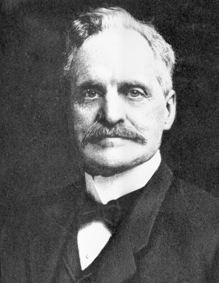
This street is named for Judge Thomas Burke (1849–1925), after whom the Burke–Gilman Trail and Burke Museum of Natural History and Culture are also named. In 1875, Burke, who was friends with the Bagley family, came to Seattle from Michigan, where he had attended law school. He began working with John McGilvra and ended up marrying his daughter, Caroline. He and Daniel Gilman were two of the founders of the Seattle, Lake Shore and Eastern Railway in 1885; the Burke–Gilman Trail today runs over the old railroad right-of-way. The Burke Museum, founded in 1885 by the Young Naturalists’ Society as Naturalists’ Hall, became the Washington State Museum in 1899 and took Burke’s name in the 1960s as part of a bequest from Caroline, who died seven years after her husband. He is also remembered for his defense of the rule of law during the period of peak anti-Chinese agitation in the 1880s. (He wanted the Chinese laborers to leave Seattle, but for this to happen non-violently, as opposed to what had happened in Tacoma.)
Thomas Burke, ca. 1910
Burke Avenue N begins at N Northlake Way and the Burke–Gilman Trail just north of Gas Works Park, and goes 1¼ miles north to N 50th Street. It resumes for a block at the north end of Green Lake between N 80th Street and N 82nd Street, and picks up again north of Bishop Blanchet High School at N 85th Street, going ⅓ of a mile north to N 92nd Street, where it becomes College Way N. With the exception of a few short segments, its next appearance is at N 135th Street, where it goes ½ a mile north to the city limits at N 145th Street. As with many other North Seattle avenues, the name continues on into Shoreline, and last appears as a short stub just north of N 203rd Street.
Born and raised in Seattle, Benjamin Donguk Lukoff had his interest in local history kindled at the age of six, when his father bought him settler granddaughter Sophie Frye Bass’s Pig-Tail Days in Old Seattle at the gift shop of the Museum of History and Industry. He studied English, Russian, and linguistics at the University of Washington, and went on to earn his master’s in English linguistics from University College London. His book of rephotography, Seattle Then and Now, was published in 2010. An updated version came out in 2015.
When I first posted this article, I wrote that Bagley Avenue N was named for Reverend Daniel Bagley (1818–1905) and his son, Clarence B. Bagley (1843–1932). That, after all, is what Sophie Frye Bass says in Pig-Tail Days in Old Seattle, which I pretty much took as gospel growing up. Junius Rochester says the same thing in his HistoryLink.org article on the Bagleys (using, I think, Pig-Tail Days as a reference.) And C.T. Conover (himself namesake of E Conover Court) repeats the story on two separate occasions for The Seattle Times — on February 18, 1950, and April 11, 1960.
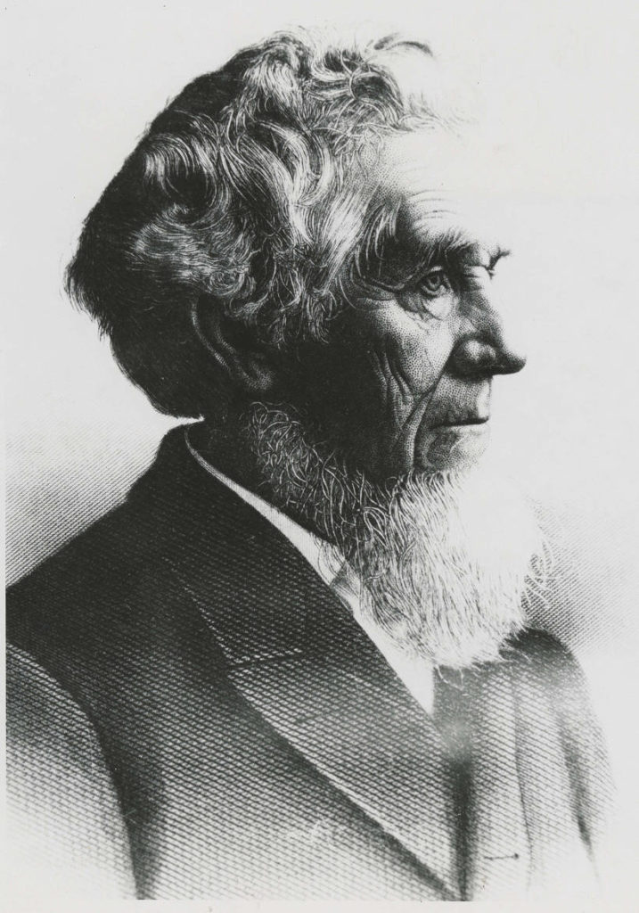
However, today (September 10, 2021), I noticed that Conover had written a follow-up to his April 11 article. On April 25, 1960, he wrote that Clarence’s son, Colonel Cecil Clarence Bagley, had sent him a letter saying that, decades previous, he had asked his father if Bagley Avenue was named for his family. Daniel said no, it was named for Dr. Herman Beardsley Bagley (1845–1899). He had filed the plat of Bagley’s Addition in 1883. A small tract northeast of what is today Gas Works Park along the Lake Union shoreline, one of its streets was named Day Street. This later needed to be changed as it was duplicative of another Day Street elsewhere in the city. (I presume this is the S Day Street in Mount Baker that was almost entirely obliterated by the construction of what is now Interstate 90.) I can’t find the ordinance in question but, Conover continues, “as this was the central street in Dr. Bagley’s addition, it was considered appropriate to rename it Bagley Avenue in his honor, and that was done.”
The biography also says he was president for a time of the Seattle Improvement Company, which appears to be another name for the Lake Washington Improvement Company, one of many schemes to build what is today the Lake Washington Ship Canal. Jennifer Ott writes for HistoryLink.org that David T. Denny, along with Bagley and J. W. George, Corliss P. Stone, Thomas Burke, Frederick H. Whitworth, Benjamin F. Day, Erasmus M. Smithers, G. M. Bowman, Guy C. Phinney, John W. Van Brocklin, and William H. Llewellyn, formed the company in 1883, and, using Chinese laborers digging by hand, dug early versions of what are now the Fremont Cut and Montlake Cut.
Dr. Herman Beardsley Bagley
Even though it appears that Bagley Avenue N was not named for Daniel and Clarence Bagley, I’m leaving their biographical information as I originally wrote it, followed by the usual description of the street’s route.
The Bagleys came west in 1852 with, among others, Thomas Mercer and Dexter Horton, two other names familiar to those interested in Seattle history, but didn’t arrive in Seattle until 1860. The elder Bagley was one of the founders of the University of Washington in 1861; the younger was its first college student. Daniel Bagley also founded the Methodist Protestant “Little Brown Church” in 1865, so called to distinguish it from Seattle’s first church, the Methodist Episcopal “Little White Church.” (This church finally closed in 1993, by which time it had become the Capitol Hill United Methodist Church.) Clarence, who went on to marry one of Thomas Mercer’s daughters, is best remembered today for his multi-volume works on local history, including History of Seattle from the Earliest Settlement to the Present Timeand History of King County, Washington.
Daniel Bagley
Clarence B. Bagley
Bagley Avenue N begins at N 35th Street and N Pacific Street and goes a mile north to the Meridian Playground/Good Shepherd Center. It resurfaces north of Green Lake at E Green Lake Drive N and goes ½ a mile to N 85th Street. Besides a block-long stretch from N 106th Street to N 107th Street and another one north of N 133rd Street, it finishes up with a ¼-mile run from N 140th Street to the northern city limits at N 145th Street. Unlike many other North Seattle avenues, the name stops there and does not continue on into Shoreline, though there is a Bagley Drive N at the Ballinger Commons housing development.
Born and raised in Seattle, Benjamin Donguk Lukoff had his interest in local history kindled at the age of six, when his father bought him settler granddaughter Sophie Frye Bass’s Pig-Tail Days in Old Seattle at the gift shop of the Museum of History and Industry. He studied English, Russian, and linguistics at the University of Washington, and went on to earn his master’s in English linguistics from University College London. His book of rephotography, Seattle Then and Now, was published in 2010. An updated version came out in 2015.
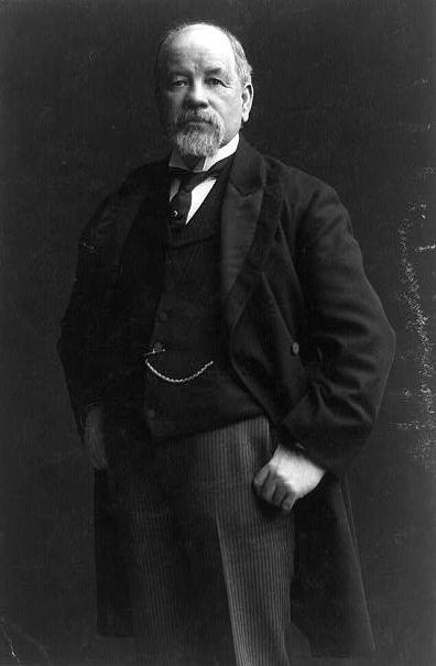
Wallingford Avenue and the Wallingford neighborhood are named for real estate developer John Noble Wallingford (1833–1913). Originally from Maine, he moved to Massachusetts, then Minnesota as a young man. He fought for the Union all four years of the Civil War, and later moved to California before coming to Seattle in 1888. He was a city councilman from 1889 to 1891 and also a police commissioner.
John Noble Wallingford, ca. 1893
Wallingford Avenue N begins as the Wallingford Steps at N Northlake Way, just north of Gas Works Park. It then goes 1⅔ miles north from N 34th Street to Woodlawn Avenue N, just south of Green Lake. At the north end of Green Lake, it goes 1⅓ miles north from E Green Lake Drive N to N 105th Street at Mineral Springs Park. It picks up again at N 135th Street, just north of Ingraham High School, and goes ½ a mile to the northern city limits at N 145th Street. As with many other North Seattle avenues, the name continues on into Shoreline; its northernmost appearance is at the King–Snohomish county line at N 205th Street.
Born and raised in Seattle, Benjamin Donguk Lukoff had his interest in local history kindled at the age of six, when his father bought him settler granddaughter Sophie Frye Bass’s Pig-Tail Days in Old Seattle at the gift shop of the Museum of History and Industry. He studied English, Russian, and linguistics at the University of Washington, and went on to earn his master’s in English linguistics from University College London. His book of rephotography, Seattle Then and Now, was published in 2010. An updated version came out in 2015.
Corliss Avenue N begins at N Northlake Way on the borth shore of Lake Union and goes nearly a mile north through Wallingford to the Good Shepherd Center just north of N 46th Street. There is another stretch from N 59th Street to N 65th Street in Green Lake. North of the lake, Corliss goes nearly another mile from East Green Lake Drive N to N 92nd Street and the North Seattle College campus. There are a few more segments through Haller Lake, the longest one being ¾ of a mile long from N 130th Street to the city limits at N 145th Street. As with other North Seattle avenues, the name continues on into Shoreline; its northernmost appearance is at N 194th Street.
Born and raised in Seattle, Benjamin Donguk Lukoff had his interest in local history kindled at the age of six, when his father bought him settler granddaughter Sophie Frye Bass’s Pig-Tail Days in Old Seattle at the gift shop of the Museum of History and Industry. He studied English, Russian, and linguistics at the University of Washington, and went on to earn his master’s in English linguistics from University College London. His book of rephotography, Seattle Then and Now, was published in 2010. An updated version came out in 2015.
Stone Way N begins on the north shore of Lake Union at N Northlake Way and Waterway 22, and goes 1⅕ miles north to N 50th Street and Green Lake Way N. It forms an unofficial boundary between the Fremont and Wallingford neighborhoods.
Born and raised in Seattle, Benjamin Donguk Lukoff had his interest in local history kindled at the age of six, when his father bought him settler granddaughter Sophie Frye Bass’s Pig-Tail Days in Old Seattle at the gift shop of the Museum of History and Industry. He studied English, Russian, and linguistics at the University of Washington, and went on to earn his master’s in English linguistics from University College London. His book of rephotography, Seattle Then and Now, was published in 2010. An updated version came out in 2015.
The sleek Latona was originally built as a pleasure craft for businessman James Colman to use on the Sound. Dr. E.C. Kilbourne, a dentist with extensive real estate holdings north of Lake Union, purchased the Latona and took her to Lake Washington by way of the Duwamish River and Black River, the lake’s outlet. After a few years of serving farms, mining camps, and logging operations around Lake Washington, the Latona came through the narrow channel dug in 1886 to Portage Bay and thereafter served Lake Union.
Today, Latona Avenue NE begins as a shoreline street end just south of NE Northlake Way and goes nearly 1¾ miles north to 2nd Avenue NE and Woodlawn Avenue NE near the eastern end of Green Lake. It reappears on the other side of the Green Lake Park playground and community center at E Green Lake Drive N, and goes a further ⅓ of a mile to just past NE 77th Street, where it is stopped by Interstate 5. Finally, on the north side of I-5, it goes nearly ½ a mile from NE 81st Street to NE 91st Street, interrupted by a half-block segment just north of NE 88th Street where it takes the form of a footpath, and a half-block segment just north of NE 90th Street where it appears to have been incorporated into neighbors’ yards and driveways.
Latona Avenue NE right-of-way between NE 90th Street and NE 91st Street in Maple Leaf. The northern half is paved, but ends at an unpaved alley; the southern half appears to be serving as neighbors’ driveways at either end, the remainder being treated as part of their yards.
Born and raised in Seattle, Benjamin Donguk Lukoff had his interest in local history kindled at the age of six, when his father bought him settler granddaughter Sophie Frye Bass’s Pig-Tail Days in Old Seattle at the gift shop of the Museum of History and Industry. He studied English, Russian, and linguistics at the University of Washington, and went on to earn his master’s in English linguistics from University College London. His book of rephotography, Seattle Then and Now, was published in 2010. An updated version came out in 2015.
As explained in NE Boat Street, NE Northlake Way was originally Lake Avenue in the 1890 Brooklyn Addition to Seattle, so named because it ran along the northern shore of Lake Union. I couldn’t find an ordinance changing its name from Lake Avenue (used elsewhere, notably for what are now Westlake Avenue and Fremont Avenue N and for part of Eastlake Avenue E) to Northlake Avenue, but the latter name begins to appear in local newspapers in 1901. (Complicating matters slightly, the street appears as North Lake Avenue in the state’s 1907 plat of Lake Union Shore Lands.) Northlake Avenue began being referred to as Northlake Way in 1935, and this was made official in 1956.
Today, NE Northlake Way begins at the west end of NE Pacific Street under the University Bridge at Eastlake Place NE, and continues 1½ miles west to just shy of the Aurora Bridge, where it becomes a private road through formerly industrial land developed by the Fremont Dock Company into a business park. (The Puget Sound Business Journal and The Seattle Times have good articles on how over the years Suzie Burke transformed her father’s Burke Millwork Co., which opened in 1939, into what is today home to local offices for Google and Adobe and corporate headquarters for Tableau and Brooks Sports, among other tenants.) This private roadway continues for ⅖ of a mile beyond the end of the public right-of-way to the intersection of N Canal Street, N 34th Street, and Phinney Avenue N.
NE Northlake Way once began ⅖ of a mile further east, at NE Columbia Road on the University of Washington South Campus, but this stretch was changed to NE Boat Street in 1962, not without some controversy.
Born and raised in Seattle, Benjamin Donguk Lukoff had his interest in local history kindled at the age of six, when his father bought him settler granddaughter Sophie Frye Bass’s Pig-Tail Days in Old Seattle at the gift shop of the Museum of History and Industry. He studied English, Russian, and linguistics at the University of Washington, and went on to earn his master’s in English linguistics from University College London. His book of rephotography, Seattle Then and Now, was published in 2010. An updated version came out in 2015.


