This street, created in 1931, was almost certainly named for Camano Island (known as ʔəw̓alus in Lushootseed), which is located, as Wikipedia tells us, in Puget Sound “between Whidbey Island and the mainland… by the Saratoga Passage to the west and Port Susan and Davis Slough to the east.” The timeline of its naming:
The strait connecting Puget Sound to the Strait of Juan de Fuca was named Ensenada de Caamaño by the Quimper Expedition in 1790. Jacinto Caamaño Moraleja was a fellow Spanish explorer of the Pacific Northwest.
ʔəw̓alus was named Macdonough Island by the Wilkes Expedition in 1841.
In 1847, Vice Admiral Sir Henry Kellett of the Royal Navy resurrected the Camano name (after having altered its spelling) and applied it to Macdonough Island.
S Camano Place begins at Renton Avenue S between S Thistle Street and S Cloverdale Street and goes 425 east to a cul-de-sac.
Born and raised in Seattle, Benjamin Donguk Lukoff had his interest in local history kindled at the age of six, when his father bought him settler granddaughter Sophie Frye Bass’s Pig-Tail Days in Old Seattle at the gift shop of the Museum of History and Industry. He studied English, Russian, and linguistics at the University of Washington, and went on to earn his master’s in English linguistics from University College London. His book of rephotography, Seattle Then and Now, was published in 2010. An updated version came out in 2015.
This street was created in 1955 as part of the plat of the Lowrain Park Addition, filed by A.L. Wood and J.E. Wood of Lowrain Park, Inc. Their full names would appear to be Adlai Lorain Wood (1891–1981) and Jack Earl Wood (1919–1995), his son. I am going to guess they named the street after themselves, the subdivision being in the southeasternmost part of the city.
S Eastwood Drive begins at 59th Avenue S and goes a block east to 61st Avenue S.
Born and raised in Seattle, Benjamin Donguk Lukoff had his interest in local history kindled at the age of six, when his father bought him settler granddaughter Sophie Frye Bass’s Pig-Tail Days in Old Seattle at the gift shop of the Museum of History and Industry. He studied English, Russian, and linguistics at the University of Washington, and went on to earn his master’s in English linguistics from University College London. His book of rephotography, Seattle Then and Now, was published in 2010. An updated version came out in 2015.
This cul-de-sac was created in 1984 as part of the plat of Valley Ridge, and was named after the nearby S Raymond Street. Raymond Street was itself named by and for Herbert R. Raymond (1862–1933), and his wife, Minnie M. Raymond (1874–1947), née Truax.
Herbert Raymond in May 1922 ― see S Raymond Street for the Seattle Times article this photo was taken from
Born and raised in Seattle, Benjamin Donguk Lukoff had his interest in local history kindled at the age of six, when his father bought him settler granddaughter Sophie Frye Bass’s Pig-Tail Days in Old Seattle at the gift shop of the Museum of History and Industry. He studied English, Russian, and linguistics at the University of Washington, and went on to earn his master’s in English linguistics from University College London. His book of rephotography, Seattle Then and Now, was published in 2010. An updated version came out in 2015.
This street was named in 1906 as Raymond Avenue, part of Replat Tracts 30 & 31 Sunnyside 5 Acre Tracts, by Herbert R. Raymond (1862–1933) of New Brunswick, Canada, and his wife, Minnie M. Raymond (1874–1947), née Truax, of Massachusetts. In 1907, it and Spencer Avenue became Raymond Street as part of the renaming of streets in Beacon Hill and Rainier Valley, and Grand Avenue, Grand View Avenue, and Sixteenth Street in West Seattle took the name as well. Three years later, when Georgetown was annexed, Raymond Street replaced James Street. (All this information from Rob Ketcherside’s extremely useful searchable table of street name changes.)
Herbert came to Washington as a child, along with his family; Minnie appears to have come later, and the two married in 1895. His eldest brother, George (Herbert was the youngest of eight children), sold shoes in Seattle and was also on the city council and in the territorial, as it then was, legislature. He later moved to Bellingham and was on the city council there in 1912 and 1913, and was mayor for less than two months, in December 1915 and January 1916, his term ending with his sudden death.
Herbert himself was also in the shoe business. As his Seattle Times obituary put it, he was:
Formerly one of the Pacific Northwest’s prominent shoe merchants and leading civic spirits… He had been retired for the past twelve years and had spent most of his time out of doors improving his two-acre residential property which overlooks Lake Washington. Mr. Raymond came to Seattle four years before the Seattle fire and helped fight it. His first shoe store was at First Avenue near Madison Street. He operated in other locations and under other firm names in subsequent years.
Article in the May 7, 1922, Seattle Times, about deer grazing on Herbert Raymond’s lawn and in his orchard. “I believe they came originally from Mercer Island, swimming across to Seward Park. There are no dogs about and the tempting green stuff in my garden coaxed them over the fence…. I don’t see a chance to grow a garden. But the deer are worth it. Their beauty more than repays for their feed.” Download the article as a PDF.
S Raymond Street begins at 51st Place S and goes just over ⅕ of a mile west to 48th Avenue S. It resumes at 44th Avenue S and goes a block west to 42nd Avenue S. There is another short segment that goes 1½ blocks west from Martin Luther King Jr. Way S, and then a longer segment begins at 33rd Avenue S and goes ½ a mile west to Beacon Avenue S, the portion crossing the Chief Sealth Trail being a pathway. A few more segments appear between 24th Avenue S and Swift Avenue S.
SW Raymond Street begins in West Seattle at High Point Drive SW and SW Graham Street and goes 1¼ miles west to 49th Avenue SW.
Born and raised in Seattle, Benjamin Donguk Lukoff had his interest in local history kindled at the age of six, when his father bought him settler granddaughter Sophie Frye Bass’s Pig-Tail Days in Old Seattle at the gift shop of the Museum of History and Industry. He studied English, Russian, and linguistics at the University of Washington, and went on to earn his master’s in English linguistics from University College London. His book of rephotography, Seattle Then and Now, was published in 2010. An updated version came out in 2015.
As part of the Great Renaming of 1895, Texas Street, Town Street, Fontenelle Street, Flemming Street, Davidson Street, and Canal Street became Atlantic Street, from Elliott Bay to Lake Washington. The name was extended into West Seattle in 1907, when Grant Street and Louisiana Street were combined.
Today, SW Atlantic Street begins in West Seattle at Sunset Avenue SW and goes ¼ of a mile east to Palm Avenue SW. It next appears, as S Atlantic Street, just east of U.S. Coast Guard Base Seattle at Alaskan Way S, and goes around 800 feet east to 1st Avenue S, where it becomes Edgar Martinez Drive S (renamed in honor of the ball player in 2004). Apart from a stub east of Airport Way S that is soon blocked by Interstate 5, the street’s next appearance is on Beacon Hill, where it goes ⅓ of a mile from just west of 11th Avenue S to 17th Avenue S, the portion between 15th Avenue S and 16th Avenue S being a stairway.
After being interrupted for a number of blocks by Interstate 90, S Atlantic Street reappears at 21st Avenue S and goes a block to just east of 22nd Avenue S. (Here, it gives its name to the surrounding Atlantic neighborhood.) It resumes — again having been interrupted by Interstate 90’s Mount Baker Tunnel — at Bradner Place S and goes ⅓ of a mile east to Lake Washington Boulevard S, the portions between 30th Avenue S and 31st Avenue South as well as between 32nd Avenue S and 33rd Avenue S being stairways. The right-of-way begins again at 35th Avenue S and goes around ⅛ of a mile east to Lake Washington, but is either incorporated into adjacent homeowners’ yards or serves as their driveways for most of this distance. Between Lakeside Avenue S and the water, it is one of the city’s shoreline street ends.
Born and raised in Seattle, Benjamin Donguk Lukoff had his interest in local history kindled at the age of six, when his father bought him settler granddaughter Sophie Frye Bass’s Pig-Tail Days in Old Seattle at the gift shop of the Museum of History and Industry. He studied English, Russian, and linguistics at the University of Washington, and went on to earn his master’s in English linguistics from University College London. His book of rephotography, Seattle Then and Now, was published in 2010. An updated version came out in 2015.
SW Massachusetts Street begins in West Seattle at the intersection of Bonair Drive SW, 47th Avenue SW, and Sunset Avenue SW, and goes just under ⅓ of a mile east to Palm Avenue SW. It begins again at Ferry Avenue SW and goes just over 450 feet east to Victoria Avenue SW. There is a short segment (just over 400 feet) on Harbor Island east of 13th Avenue SW, and then another one, about the same length, leading from Alaskan Way S to the entrance to U.S. Coast Guard Base Seattle. (Here, the street’s directional designation has changed to S, it being east of the Duwamish Waterway.)
S Massachusetts Street resumes at Colorado Avenue S and goes ⅙ of a mile east to Occidental Avenue S. There is a block-long segment east of 4th Avenue S to just shy of the SODO Busway, and then a longer one — about ¼ of a mile — from the SODO Trail to Airport Avenue S.
East of Interstate 5, on Beacon Hill, S Massachusetts Street begins at 11th Avenue S and goes nearly ¼ of a mile east to just past 15th Avenue S, the portion between 14th Avenue S and 15th Avenue S being pedestrian-only, as the right-of-way between the sidewalks has been turned into the Beacon Bluff P-Patch community garden. It begins again just west of Sturgus Avenue S and goes nearly a mile east to just past 31st Avenue S, the portion that runs for half a block west of 17th Avenue S being a pathway. S Massachusetts Street resumes for the last time at 32nd Avenue S and goes ¼ mile east to Lake Washington, where it is a shoreline street end.
Born and raised in Seattle, Benjamin Donguk Lukoff had his interest in local history kindled at the age of six, when his father bought him settler granddaughter Sophie Frye Bass’s Pig-Tail Days in Old Seattle at the gift shop of the Museum of History and Industry. He studied English, Russian, and linguistics at the University of Washington, and went on to earn his master’s in English linguistics from University College London. His book of rephotography, Seattle Then and Now, was published in 2010. An updated version came out in 2015.
This street received its name in 1907, uniting streets formerly known as Nebraska Street, 8th Street, Bedford Street, Conover Street, and G Street. (There had been an Oregon Street in the 1895 Seattle Tide Lands plat in which Nebraska Street was created, but it became Spokane Street and Chelan Avenue in the same 1907 change.)
S Oregon Street begins in West Seattle as SW Oregon Street at the Emma Schmitz Memorial Overlook on Beach Drive SW and goes two blocks east to Me-Kwa-Mooks Park at 56th Avenue SW. It briefly resumes at 52nd Avenue SW and goes two blocks east to 51st Avenue SW, then begins again in earnest at 50th Avenue SW, going nearly a mile east to the West Seattle Stadium at 35th Avenue SW, part of the stretch between there and Fauntleroy Way SW being footpath and stairway. East of the West Seattle Golf Course, it goes around 175 feet to 26th Avenue SW and the Delridge Playfield, and on the other side of the playfield serves as a short connector between Delridge Way SW and 23rd Avenue SW.
S Oregon Street resumes east of the Duwamish Waterway at a shoreline street end and goes ¼ mile east to E Marginal Way S. It then serves as short connectors between Diagonal Avenue S and Denver Avenue S and between 7th Avenue S and Airport Way S.
East of Interstate 5, on Beacon Hill, S Oregon Street begins again at 10th Avenue S and goes ⅓ of a mile east to 15th Avenue S and S Columbian Way. It picks up again in the Rainier Valley at S Columbian Way and Martin Luther King Jr. Way S and goes ⅔ of a mile east to Genesee Park at 42nd Avenue S. East of the park, it resumes at 47th Avenue S and goes ¼ mile east to its end at 52nd Avenue S above the Lakewood Marina on Lake Washington.
Born and raised in Seattle, Benjamin Donguk Lukoff had his interest in local history kindled at the age of six, when his father bought him settler granddaughter Sophie Frye Bass’s Pig-Tail Days in Old Seattle at the gift shop of the Museum of History and Industry. He studied English, Russian, and linguistics at the University of Washington, and went on to earn his master’s in English linguistics from University College London. His book of rephotography, Seattle Then and Now, was published in 2010. An updated version came out in 2015.
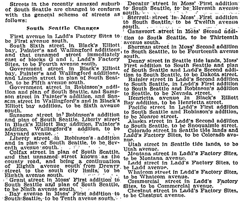
Article listing South Seattle street name changes in January 14, 1906, issue of the Seattle Post-Intelligencer
SW Nevada Street begins in West Seattle at 30th Avenue SW and goes ¼ mile east to 26th Avenue SW. It next appears east of the Duwamish Waterway in the Industrial District, as a ¼-mile-long service road off E Marginal Way S and a 300-foot-long dead-end road off 6th Avenue S. East of Interstate 5 on Beacon Hill, it goes ¼ mile east from 11th Avenue S to 16th Avenue S at Jefferson Park. It resumes for the last time in Rainier Valley at 28th Avenue S and S Adams Street and goes ¼ mile east to 31st Avenue S.
Born and raised in Seattle, Benjamin Donguk Lukoff had his interest in local history kindled at the age of six, when his father bought him settler granddaughter Sophie Frye Bass’s Pig-Tail Days in Old Seattle at the gift shop of the Museum of History and Industry. He studied English, Russian, and linguistics at the University of Washington, and went on to earn his master’s in English linguistics from University College London. His book of rephotography, Seattle Then and Now, was published in 2010. An updated version came out in 2015.
Streets in this plat that were not extensions of already existing ones, such as Commercial Street, were named after letters of the alphabet, American cities, American states, prominent local politicians, and places in Washington.… the states appear neither in alphabetical nor geographic order.
In this case, of course, the street was named for the Dakotas, not for South Dakota.
SW Dakota Street begins at 56th Avenue SW and goes 1⅓ miles east to 34th Avenue SW. It resumes at 30th Avenue SW and goes a further ⅓ of a mile east to Delridge Way SW, the portion between 28th Avenue SW and 26th Avenue SW being footpaths through the Longfellow Creek Natural Area park. SW Dakota Street begins again just west of 21st Avenue SW and goes just over 750 feet east to 19th Avenue SW, and there is one final segment west of the Duwamish Waterway between 16th Avenue SW and W Marginal Way SW.
East of the Duwamish, S Dakota Street runs for a block between 1st Avenue S and 2nd Avenue S, then picks up again at 6th Avenue S and goes ¼ mile east to 9th Avenue S. East of Interstate 5 on Beacon Hill, S Dakota Street resumes at 12th Avenue S and goes another ¼ mile east to Jefferson Park at 16th Avenue S. It begins again in the Rainier Valley at 29th Avenue S and goes ⅓ of a mile east to 34th Avenue S, picking up again at Rainier Avenue S and going ⅖ of a mile east to Genesee Park at 43rd Avenue S. On the other side of the park, it resumes at 46th Avenue S and goes ⅓ of a mile east to its end at 51st Avenue S, overlooking Lake Washington.
Born and raised in Seattle, Benjamin Donguk Lukoff had his interest in local history kindled at the age of six, when his father bought him settler granddaughter Sophie Frye Bass’s Pig-Tail Days in Old Seattle at the gift shop of the Museum of History and Industry. He studied English, Russian, and linguistics at the University of Washington, and went on to earn his master’s in English linguistics from University College London. His book of rephotography, Seattle Then and Now, was published in 2010. An updated version came out in 2015.
At 12,281 feet, Adams is the second tallest mountain in Washington, behind Mount Rainier. Known by Native Americans as Pahto or Klickitat, it was named for President John Adams (1735–1826), in a rather roundabout way. Unlike Rainier or St. Helens, it was neither “discovered” by George Vancouver nor named by him; instead, the first non-Natives to spot it were Lewis and Clark, who at first thought they had spotted St. Helens. Then, as Wikipedia relates,
For several decades after Lewis and Clark sighted the mountain, people continued to get Adams confused with St. Helens, due in part to their somewhat similar appearance and similar latitude. In the 1830s, Hall J. Kelley led a campaign to rename the Cascade Range as the President’s Range and rename each major Cascade mountain after a former president of the United States. Mount Adams was not known to Kelley and was thus not in his plan. Mount Hood, in fact, was designated by Kelley to be renamed after President John Adams and St. Helens was to be renamed after George Washington. In a mistake or deliberate change by mapmaker and proponent of the Kelley plan Thomas J. Farnham, the names for Hood and St. Helens were interchanged. And, likely because of the confusion about which mountain was St. Helens, he placed the Mount Adams name north of Mount Hood and about 40 miles (64 km) east of Mount St. Helens. By what would seem sheer coincidence, there was in fact a large mountain there to receive the name. Since the mountain had no official name at the time, Kelley’s name stuck even though the rest of his plan failed.However, it was not official until 1853, when the Pacific Railroad Surveys, under the direction of Washington Territory governor Isaac I. Stevens, determined its location, described the surrounding countryside, and placed the name on the map.
Mount Adams Place S begins at Mount St. Helens Place S and goes ¼ mile southeast to S Ferris Place.
Born and raised in Seattle, Benjamin Donguk Lukoff had his interest in local history kindled at the age of six, when his father bought him settler granddaughter Sophie Frye Bass’s Pig-Tail Days in Old Seattle at the gift shop of the Museum of History and Industry. He studied English, Russian, and linguistics at the University of Washington, and went on to earn his master’s in English linguistics from University College London. His book of rephotography, Seattle Then and Now, was published in 2010. An updated version came out in 2015.
St. Helens, of course, is best known for its volcanic eruption on May 18, 1980, “the deadliest and most economically destructive volcanic event in U.S. history” according to Wikipedia. It was variously known by the Native Americans as Lawetlat’la (Cowlitz) and Loowit or Louwala-Clough (Klickitat), and, like Mount Rainier and Mount Baker, was given its official English-language name by George Vancouver on HMS Discovery in 1792. In this case, it honored his friend Alleyne FitzHerbert, 1st Baron St Helens (1753–1839), who at the time was British ambassador to Spain.
Mount St. Helens Place S begins at Cascadia Avenue S and goes just over ¼ mile south to Mount Rainier Drive S at 37th Avenue S.
Born and raised in Seattle, Benjamin Donguk Lukoff had his interest in local history kindled at the age of six, when his father bought him settler granddaughter Sophie Frye Bass’s Pig-Tail Days in Old Seattle at the gift shop of the Museum of History and Industry. He studied English, Russian, and linguistics at the University of Washington, and went on to earn his master’s in English linguistics from University College London. His book of rephotography, Seattle Then and Now, was published in 2010. An updated version came out in 2015.
This street was created in 1907 as part of the Mt. Baker Park addition, named for its view of Mount Baker in the North Cascades. In addition to S Mount Baker Boulevard, the neighborhood featured a number of other streets named for mountains in the Cascade Range, including this one, named after Mount Rainier.
According to Wikipedia, at 14,411 feet, Mount Rainier is “the highest mountain in… Washington and the Cascade Range, the most topographically prominent mountain in the contiguous United States, and the tallest in the Cascade Volcanic Arc.” It has been known by a number of other names, including Tacoma (after which, incidentally, Takoma Park, Maryland, was named), which derived from its Lushootseed-language name, təqʷubəʔ (‘permanently snow-covered mountain’). It was given its official English-language name by George Vancouver on HMS Discovery in 1792:
The weather was serene and pleasant, and the country continued to exhibit between us and the eastern snowy range the same luxuriant appearance. At is northern extremity, Mount Baker bore by compass N. 22 E.; the round snowy mountain, now forming its southern extremity, and which, after my friend, Rear Admiral [Peter] Rainier [1741–1808], I distinguish by the name of Mount Rainier, bore N. 42 E.
Mount Rainier Drive S begins at the intersection of S McClellan Street, Lake Park Drive S, and Mount Baker Drive S, and goes ¼ mile southeast to S Hanford Street and Hunter Boulevard S.
Born and raised in Seattle, Benjamin Donguk Lukoff had his interest in local history kindled at the age of six, when his father bought him settler granddaughter Sophie Frye Bass’s Pig-Tail Days in Old Seattle at the gift shop of the Museum of History and Industry. He studied English, Russian, and linguistics at the University of Washington, and went on to earn his master’s in English linguistics from University College London. His book of rephotography, Seattle Then and Now, was published in 2010. An updated version came out in 2015.
Like its neighbors S Hudson Street and S Americus Street, S Ferdinand Street was created in 1891 as part of the plat of Columbia. (The town incorporated in 1893 and was annexed to Seattle in 1907, becoming the neighborhood of Columbia City.) Along with Columbus Street, which no longer exists, they were part a of series of streets named after explorers — in this case, Ferdinand Magellan (born Fernão de Magalhães, also known as Fernando de Magallanes) (1480–1521), the first explorer to sail from Europe to Asia via the Atlantic and Pacific Oceans.
S Ferdinand Street begins at Lake Washington Boulevard S and goes a block west to just past 55th Avenue S. It is a stairway between 54th Avenue S and 53rd Avenue S, then begins again at 52nd Avenue S. After a half block as roadway and another half block as stairway, it begins in earnest at 51st Avenue S by Lakewood Park and goes just over a mile west to 31st Avenue S. It is another stairway for the next block, and then a stub off 30th Avenue S.
On Beacon Hill, S Ferdinand Street begins again at 28th Avenue S and goes ½ a mile west to 20th Avenue S, then resumes at 19th Avenue S and goes a further ⅖ to 13th Avenue S. It finishes up as a short connector from 12th Avenue S to Corson Avenue S by Maple Wood Playfield.
Born and raised in Seattle, Benjamin Donguk Lukoff had his interest in local history kindled at the age of six, when his father bought him settler granddaughter Sophie Frye Bass’s Pig-Tail Days in Old Seattle at the gift shop of the Museum of History and Industry. He studied English, Russian, and linguistics at the University of Washington, and went on to earn his master’s in English linguistics from University College London. His book of rephotography, Seattle Then and Now, was published in 2010. An updated version came out in 2015.
This street was created in 1891 as part of the plat of Columbia, which incorporated in 1893 and was annexed to Seattle in 1907, becoming the neighborhood of Columbia City. Part of a series of streets named after explorers — (Christopher) Columbus Street (subsequently changed to Edmunds Street), Ferdinand (Magellan) Street, and Americus (Vespucci) Street — it was named for English explorer Henry Hudson (c. 1565–disappeared 1611), namesake of Hudson Bay in Canada and the Hudson River in New York and New Jersey.
After a false start as a dead-end road west of 57th Avenue S, S Hudson Street begins at 53rd Avenue S and goes ⅓ of a mile west to 47th Avenue S, becoming a stairway between 50th Avenue S and 49th Avenue S. It resumes at 46th Avenue S and goes ¾ of a mile west to Martin Luther King Jr. Way S. After another couple of short segments, it begins again at 28th Avenue S and goes ¼ mile west to 24th Avenue S. There are two more short segments on Beacon Hill, and then Hudson Street resumes in Georgetown, going ⅖ of a mile from 4th Avenue S to E Marginal Way S.
In West Seattle, SW Hudson Street begins as a service road and footpath within Puget Park off 18th Avenue SW. Its first appearance as a residential street is at Puget Boulevard SW, where it goes ⅕ of a mile to the West Seattle Golf Course. It then picks up again at 35th Avenue SW, where it goes just over a mile to SW Jacobsen Road, becoming a stairway three separate times along the way.
Born and raised in Seattle, Benjamin Donguk Lukoff had his interest in local history kindled at the age of six, when his father bought him settler granddaughter Sophie Frye Bass’s Pig-Tail Days in Old Seattle at the gift shop of the Museum of History and Industry. He studied English, Russian, and linguistics at the University of Washington, and went on to earn his master’s in English linguistics from University College London. His book of rephotography, Seattle Then and Now, was published in 2010. An updated version came out in 2015.
This street was created in 1891 as part of the plat of Columbia, which incorporated in 1893 and was annexed to Seattle in 1907, becoming the neighborhood of Columbia City. It was part of a series of streets named after explorers. Columbus Street, named for Christopher Columbus, is no more, but Ferdinand Street (Ferdinand Magellan), Hudson Street (Henry Hudson), and Americus Street (named for Amerigo Vespucci [1451–1512]) still exist. (Vespucci, of course, is the namesake of the Americas).
S Americus Street exists in two short segments: the Columbia City one begins at 42nd Avenue S and goes a block west to 39th Avenue S, and the Beacon Hill one begins at 26th Avenue S and goes a block west to S Columbian Way.
Born and raised in Seattle, Benjamin Donguk Lukoff had his interest in local history kindled at the age of six, when his father bought him settler granddaughter Sophie Frye Bass’s Pig-Tail Days in Old Seattle at the gift shop of the Museum of History and Industry. He studied English, Russian, and linguistics at the University of Washington, and went on to earn his master’s in English linguistics from University College London. His book of rephotography, Seattle Then and Now, was published in 2010. An updated version came out in 2015.
S Orcas Street begins at E Marginal Way S and goes ¾ of a mile east, then southeast, to Corson Avenue S, where it becomes S Doris Street. It picks up again east of Interstate 5 at 15th Avenue S and goes three blocks east to 18th Avenue S. Its longest and final stretch begins just west of 20th Avenue S and goes 2¼ miles east to Lake Washington Boulevard S just west of Seward Park.
Born and raised in Seattle, Benjamin Donguk Lukoff had his interest in local history kindled at the age of six, when his father bought him settler granddaughter Sophie Frye Bass’s Pig-Tail Days in Old Seattle at the gift shop of the Museum of History and Industry. He studied English, Russian, and linguistics at the University of Washington, and went on to earn his master’s in English linguistics from University College London. His book of rephotography, Seattle Then and Now, was published in 2010. An updated version came out in 2015.
Born and raised in Seattle, Benjamin Donguk Lukoff had his interest in local history kindled at the age of six, when his father bought him settler granddaughter Sophie Frye Bass’s Pig-Tail Days in Old Seattle at the gift shop of the Museum of History and Industry. He studied English, Russian, and linguistics at the University of Washington, and went on to earn his master’s in English linguistics from University College London. His book of rephotography, Seattle Then and Now, was published in 2010. An updated version came out in 2015.
Wetmore “founded Seattle’s first tannery and shoe making business in 1855” with Milton Daniel Woodin (1800–1869), who was the father of his wife, Ann Woodin Wetmore (1829–1886). (Woodinville, located northeast of Seattle along the Sammamish River, was named after the Woodin family.) He homesteaded land in Rainier Valley, which later became the subject of a lawsuit against him by all his children except Jane. As the Seattle Post-Intelligencer reported on September 17, 1892,
Seymour Wetmore is an old settler in this section, who took up a government claim of 160 acres of land, which lies across the present line of the Rainier avenue electric railway. With the growth of Seattle Wetmore, by the increase of the values of property, found himself quite a wealthy man.… After the death of his wife her share was divided among the seven children, each of whom received $5,500. The amount that the father has kept for himself is now valued at about $25,000.… Last July a petition was filed… asking for the appointment of a guardian for Seymour Wetmore, on the ground that he was an habitual drunkard and incapable of taking care of himself.… The eldest son… swore to the petition, which set out that the father was addicted to dangerous excess in the use of intoxicating liquors, and was in the habit of going around in the company of lewd women and squandering his money.… [Wetmore] admitted that he drank. He had always been a drinking man and always would be. But he indignantly denied the charges that he associated with lewd women. By his answers he intimated that the… proceedings were due to a desire on the part of the children to tie up his property so that they would be sure of it in case of his death.
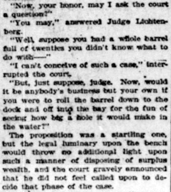
Finally, in February 1895, the matter was settled, as the Post-Intelligencer reported on the 28th under the headline ‘Seymour Wetmore Will Be Free to Squander His Wealth — He only yearns to spend it’. The article first recapped the origin of the lawsuit:
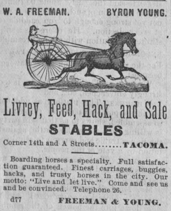
He felt as rich as any of the lords of creation, and worked himself up to the intoxication of enjoyment by spending money for the sole pleasure of seeing it go. He went about, his pockets lined with $20 pieces. This sort of thing grew tiresome to his prospective heirs, who became desperate on learning that Wetmore had entered into a deal with Byron Young, of Tacoma, whereby the latter received, in return for a bauble, $8,000 in money and 50 lots in Byron addition.
Excerpt from Seattle Post-Intelligencer article, from February 28, 1895, issue on Seymour Wetmore’s guardianship case, in which Wetmore argues for his right to do whatever he wants with his money, including destroying it
The case dragged on for a while, but, as it turns out,
Pending the decision of the supreme court the property involved had been transferred and retransferred again and again until an abstract of title would make a formidable document. In consequence the case of [Wetmore’s guardian] vs. Young was dismissed by stipulation in the equity department last Saturday. There is now nothing left to fight over, and the inevitable conclusion is that the aged ward will be found able to take care of himself.
Wetmore Avenue S begins at 30th Avenue S just south of S Hanford Street, crosses S Byron Street, and goes 800 feet southeast to S Walden Street. There is another short segment — around 150 feet long — south of S Estelle Street, which turns into a footpath of about equal length connecting to S Spokane Street.
Born and raised in Seattle, Benjamin Donguk Lukoff had his interest in local history kindled at the age of six, when his father bought him settler granddaughter Sophie Frye Bass’s Pig-Tail Days in Old Seattle at the gift shop of the Museum of History and Industry. He studied English, Russian, and linguistics at the University of Washington, and went on to earn his master’s in English linguistics from University College London. His book of rephotography, Seattle Then and Now, was published in 2010. An updated version came out in 2015.
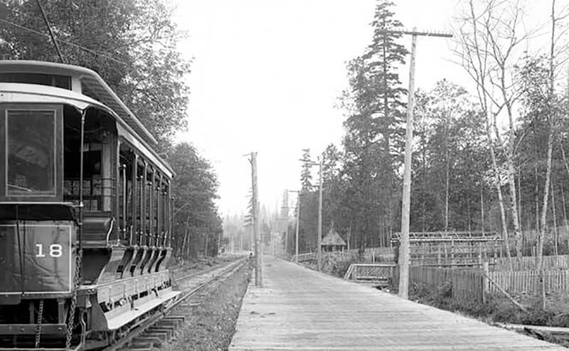
This street follows the route of the Rainier Avenue Electric Railway Company’s Seattle-to-Renton line, which began to be built in 1891. Both the rail line and street were named for Mount Rainier (təqʷubəʔ), itself named by Captain George Vancouver for his friend, Royal Navy Rear Admiral Peter Rainier (1741–1808). As the Seattle Post-Intelligencer noted on September 3, 1890, “the avenue points straight toward Mount Rainier, which mountain will be in plain view all the way.”
Rainier Avenue S begins at the intersection of S Jackson Street, Boren Avenue S, and 14th Avenue S, and goes nearly 8 miles southeast to the city limits. From there, it continues around 3¾ miles south to the intersection of Interstate 405 and State Route 167 in Renton.
Aerial view of Rainier Valley, Beacon Hill, and Downtown, May 22, 2001. Rainier Avenue S is the tree-lined street running up the middle of the photograph. Courtesy of the Seattle Municipal Archives, Identifier 114373.
Born and raised in Seattle, Benjamin Donguk Lukoff had his interest in local history kindled at the age of six, when his father bought him settler granddaughter Sophie Frye Bass’s Pig-Tail Days in Old Seattle at the gift shop of the Museum of History and Industry. He studied English, Russian, and linguistics at the University of Washington, and went on to earn his master’s in English linguistics from University College London. His book of rephotography, Seattle Then and Now, was published in 2010. An updated version came out in 2015.
S Kenny Street begins on Beacon Hill at 21st Avenue S and goes two blocks east to 23rd Avenue S. It resumes in Hillman City at 42nd Avenue S and goes ¼ mile east to a dead end east of Rainier Avenue S. Its final segment, just under 400 feet long, lies west of 51st Avenue S and dead-ends at some private driveways.
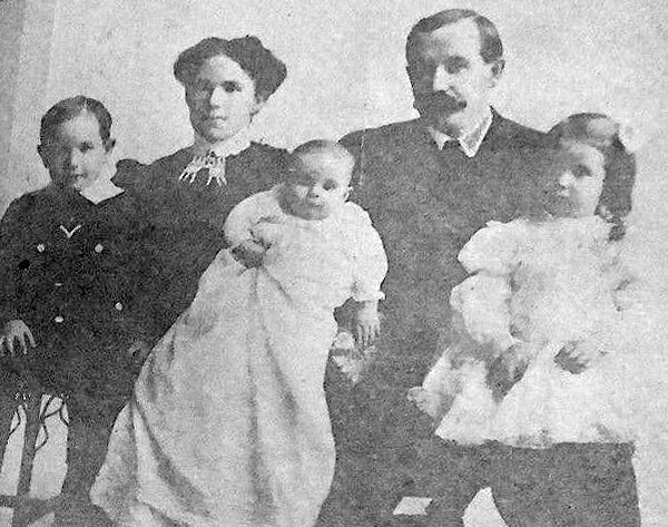
Bessie and C.D. Hillman and family, from a 1910 abstract of title for C.D. Hillman’s Birmingham Water Front Addition to the City of Everett
Born and raised in Seattle, Benjamin Donguk Lukoff had his interest in local history kindled at the age of six, when his father bought him settler granddaughter Sophie Frye Bass’s Pig-Tail Days in Old Seattle at the gift shop of the Museum of History and Industry. He studied English, Russian, and linguistics at the University of Washington, and went on to earn his master’s in English linguistics from University College London. His book of rephotography, Seattle Then and Now, was published in 2010. An updated version came out in 2015.


