This West Seattle street was created in 1937 as part of Forest View Tracts, an addition to the City of Seattle. At the time, it truly was in the middle of the forest, and still today Fauntleroy Park, “a densely wooded patch of forest in West Seattle,” lies to its north and east.
Forest Court SW begins at SW Roxbury Street between 41st Avenue SW and 42nd Avenue SW and goes around 800 feet north to a Fauntleroy Park trailhead.
Born and raised in Seattle, Benjamin Donguk Lukoff had his interest in local history kindled at the age of six, when his father bought him settler granddaughter Sophie Frye Bass’s Pig-Tail Days in Old Seattle at the gift shop of the Museum of History and Industry. He studied English, Russian, and linguistics at the University of Washington, and went on to earn his master’s in English linguistics from University College London. His book of rephotography, Seattle Then and Now, was published in 2010. An updated version came out in 2015.
This street was named as part of the 1907 plat of Loyal Heights, filed by Edward B. Cox and Harry Whitney Treat, and Treat’s wife, Olive Marion Graef Treat. Then, as now, the lots abutted a wooded (“sylvan”) area surrounding an unnamed creek that begins between Golden Gardens Drive NW and Forest Hill Place NW just north of NW 87th Street and flows to Puget Sound, heading into a culvert just south of Whitney Place NW and continuing under NW Esplanade and the BNSF Railway mainline to the privately owned North Beach.
Sylvan Place NW begins at the intersection of Loyal Avenue NW and Golden Gardens Drive NW and goes around 400 feet northeast, where it turns into Cyrus Avenue NW.
Born and raised in Seattle, Benjamin Donguk Lukoff had his interest in local history kindled at the age of six, when his father bought him settler granddaughter Sophie Frye Bass’s Pig-Tail Days in Old Seattle at the gift shop of the Museum of History and Industry. He studied English, Russian, and linguistics at the University of Washington, and went on to earn his master’s in English linguistics from University College London. His book of rephotography, Seattle Then and Now, was published in 2010. An updated version came out in 2015.
W Laurelhurst Drive NE and E Laurelhurst Drive NE were originally Olympic View Drive and Cascade View Drive, respectively, in the 1906 plat of Laurelhurst, an Addition to the City of Seattle. I am unable to tell exactly when the change was made: I first find “Laurelhurst Drive” being referred to in The Seattle Times in 1920, though a Kroll map from the same year shows the streets as 45th Avenue NE and 47th Avenue NE, respectively.
Laurelhurst itself was annexed to Seattle in 1910 (which makes me wonder why the plat was labelled as an addition to the city four years earlier). “Laurel” must refer to the tree, and “hurst” is an archaic word meaning “wooded hill.” However, as the English Language & Usage Stack Exchange thread that gives that definition notes, “in street names, [hurst is] likely to be a modern invention,” being part of “a name made up from old roots to imbue a sense of history and rootedness” (or, in cases like these, Britishness and stateliness). (I had thought that “Laurel” might refer to a girl or woman [cf. Loyal Avenue NW], but neither of the developers — Joseph Rogers McLaughlin [1851–1923] and Robert F. Booth [1875–1918] — appear to have had a relative by that name.)
(As an aside, the Wikipedia article on the Laurelhurst neighborhood in Portland, Oregon, citing Eugene E. Snyder’s 1979 Portland Names and Neighborhoods, says that “the name Laurelhurst was borrowed from a residential development in Seattle that Laurelhurst Company general manager Paul Murphy had recently completed. The name combined a reference to the laurel shrubbery near the Seattle development with the Old English hurst, denoting a wooded hill.” However, I have my doubts that there were actually enough laurels nearby to warrant the naming [in contrast to Magnolia, which was {mis}named for the plentiful madronas that lined the bluff].)
W Laurelhurst Drive NE begins at 43rd Avenue NE just south of NE 38th Street and goes ½ a mile southeast to just east of Webster Point Road NE, where it becomes E Laurelhurst Dr NE. From there, it goes nearly ⅖ of a mile northeast to a dead end just past 47th Avenue NE.
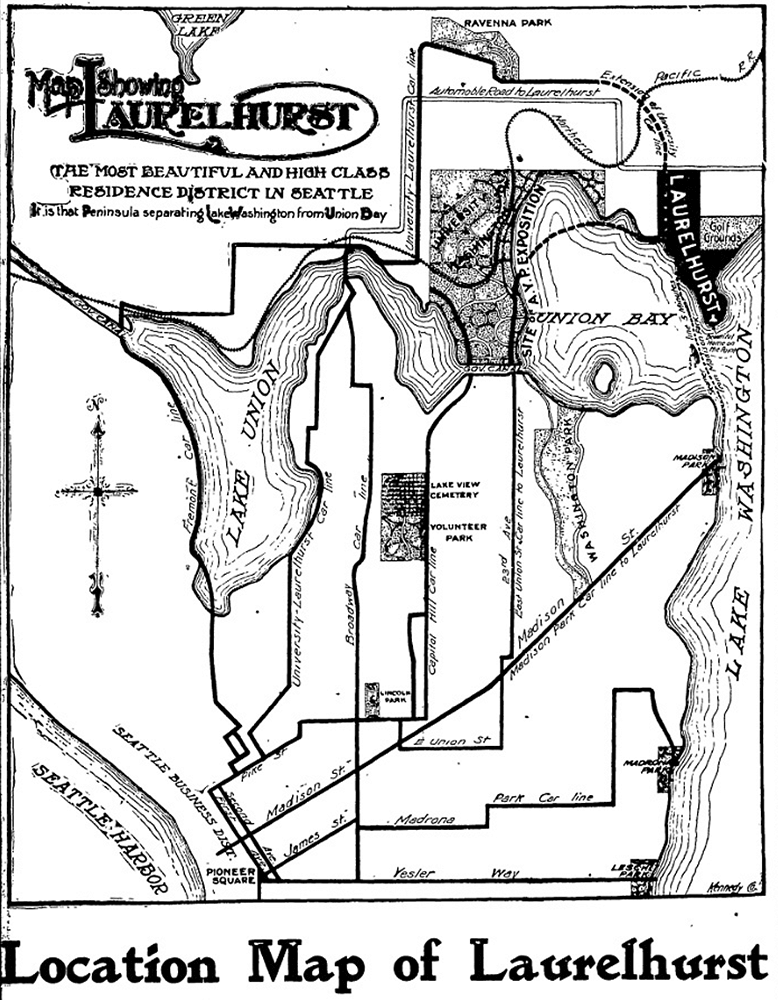
Part of an advertisement for the new Laurelhurst subdivision, Seattle Post-Intelligencer, October 21, 1906. Laurelhurst is called “the most beautiful and high-class residence district in Seattle… that peninsula separating Lake Washington from Union Bay.” Prospective buyers were directed to take the Madison Street Cable Railway to its terminus at Madison Park, from which they could take a 5-minute ride on a steamer to Laurelhurst.
Born and raised in Seattle, Benjamin Donguk Lukoff had his interest in local history kindled at the age of six, when his father bought him settler granddaughter Sophie Frye Bass’s Pig-Tail Days in Old Seattle at the gift shop of the Museum of History and Industry. He studied English, Russian, and linguistics at the University of Washington, and went on to earn his master’s in English linguistics from University College London. His book of rephotography, Seattle Then and Now, was published in 2010. An updated version came out in 2015.
This street was created in 1915 by renaming portions of Hugo Place, Grand Avenue, and E Denny Way. It was named after the Madrona neighborhood, itself named after Madrona Park, which in turn was named for the madrona or Pacific madrone tree(Arbutus menziesii). According to Seattle parks historian Don Sherwood, this was not because of the tree’s prevalence in the area — if they are characteristic of any Seattle neighborhood, it would be Magnolia. Rather,
J.E. Ayer, one of the “contributors” [of land for the park], suggested “Madrona,” based upon the presence of a few trees in the community — but scarcely more than a “few little (madrona) sprouts” in the park area. However, the name caught on and soon became the district name as well.
Madrona Drive begins at the intersection of E Denny Way, 38th Avenue, and Madrona Place E, and goes nearly ½ a mile southeast to Lake Washington Boulevard just north of Madrona Park.
Born and raised in Seattle, Benjamin Donguk Lukoff had his interest in local history kindled at the age of six, when his father bought him settler granddaughter Sophie Frye Bass’s Pig-Tail Days in Old Seattle at the gift shop of the Museum of History and Industry. He studied English, Russian, and linguistics at the University of Washington, and went on to earn his master’s in English linguistics from University College London. His book of rephotography, Seattle Then and Now, was published in 2010. An updated version came out in 2015.
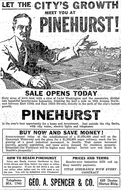
This street was established in 1926 as part of the plat of Pinehurst. Originally beginning at 15th Avenue NE and NE 117th Street and going northeast to 17th Avenue NE between NE 123rd Street and NE 125th Street, it was subsequently extended to connect the 15th Avenue NE and Roosevelt Way NE arterials.
Today, Pinehurst Way NE begins at Roosevelt Way NE and NE 113th Street, and goes ⅔ of a mile northeast to 17th Avenue NE and NE 124th Street.
Ad for Pinehurst, The Seattle Times, October 3, 1926
Born and raised in Seattle, Benjamin Donguk Lukoff had his interest in local history kindled at the age of six, when his father bought him settler granddaughter Sophie Frye Bass’s Pig-Tail Days in Old Seattle at the gift shop of the Museum of History and Industry. He studied English, Russian, and linguistics at the University of Washington, and went on to earn his master’s in English linguistics from University College London. His book of rephotography, Seattle Then and Now, was published in 2010. An updated version came out in 2015.
This street was created in 1890 as part of Hunter’s Lake Union Addition to the City of Seattle by Colonel Morton C. Hunter (1825–1896), Civil War veteran and congressman from Indiana. (His son, Frank, was an insurance and real estate man in Seattle, and it was he who requested the recording of the plat.) Absent any evidence to the contrary, I assume it was named for the tree, though it is the only such street in the plat.
Birch Avenue N begins at Halladay Street just east of Aurora Avenue N and south of Canlis, and goes 300 feet southeast to a dead end.
Born and raised in Seattle, Benjamin Donguk Lukoff had his interest in local history kindled at the age of six, when his father bought him settler granddaughter Sophie Frye Bass’s Pig-Tail Days in Old Seattle at the gift shop of the Museum of History and Industry. He studied English, Russian, and linguistics at the University of Washington, and went on to earn his master’s in English linguistics from University College London. His book of rephotography, Seattle Then and Now, was published in 2010. An updated version came out in 2015.
Elm Place SW begins at SW California Place and goes 300 feet southeast to SW Maryland Place, paralleling Harbor Avenue SW just over 100 feet to its northeast.
Born and raised in Seattle, Benjamin Donguk Lukoff had his interest in local history kindled at the age of six, when his father bought him settler granddaughter Sophie Frye Bass’s Pig-Tail Days in Old Seattle at the gift shop of the Museum of History and Industry. He studied English, Russian, and linguistics at the University of Washington, and went on to earn his master’s in English linguistics from University College London. His book of rephotography, Seattle Then and Now, was published in 2010. An updated version came out in 2015.
This private cul-de-sac at the end of 24th Avenue NE south of NE 60th Street appears, according to an article in the June 19, 1927, edition of the Seattle Post-Intelligencer, to have been established that very year. According to James Bush writing for the Seattle Sun, Ravenna Park (or perhaps a portion thereof) was once known as Twin Maple Park, and
[William Wirt] Beck is officially remembered by two of the smallest civic gestures ever performed. In keeping with the early practice of giving names to small bits of park property, the concrete-covered triangle of land at the intersection of 15th Avenue Northeast and Cowen Place was dubbed Beck Place. And, his beloved Twin Maples Park is memorialized by Twin Maples Lane Northeast, a half-block street where 24th Avenue Northeast meets the park border.
Note that the typos are in the Sun article, not this post — the sign quite clearly says Maple, not Maples.
Born and raised in Seattle, Benjamin Donguk Lukoff had his interest in local history kindled at the age of six, when his father bought him settler granddaughter Sophie Frye Bass’s Pig-Tail Days in Old Seattle at the gift shop of the Museum of History and Industry. He studied English, Russian, and linguistics at the University of Washington, and went on to earn his master’s in English linguistics from University College London. His book of rephotography, Seattle Then and Now, was published in 2010. An updated version came out in 2015.
Today, E Spruce Street begins at Broadway and goes nearly a mile east to 25th Avenue, only interrupted once, at Boren Avenue, which it connects to as a pair of stairways. It resumes at 28th Avenue and goes just over ¼ of a mile to Lake Dell Avenue (the portion from Peppi’s Playground through Peppi’s Woods as a stairway). Farther east, there is a couple-hundred-foot-long section at the west end of Euclid Avenue, and then a longer one — almost ⅒ of a mile — from near the east end of Euclid Avenue to E Alder Street. (Its complicated end is the result of platted streets not always matching up with topography, or with where people actually ended up building roads.)
King County Parcel Viewer showing E Spruce Street right-of-way from Lake Dell Avenue in the west to E Alder Street in the east. Instead of the eastern portion of Spruce connecting directly to the western portion, there is a gap; instead, the western portion connects to Euclid Avenue by going through private property.
Born and raised in Seattle, Benjamin Donguk Lukoff had his interest in local history kindled at the age of six, when his father bought him settler granddaughter Sophie Frye Bass’s Pig-Tail Days in Old Seattle at the gift shop of the Museum of History and Industry. He studied English, Russian, and linguistics at the University of Washington, and went on to earn his master’s in English linguistics from University College London. His book of rephotography, Seattle Then and Now, was published in 2010. An updated version came out in 2015.
Today, Fir Street begins where 8th Avenue and 9th Avenue meet, a block south of Harborview Medical Center. From there to its end at Martin Luther King Jr. Way 1⅕ miles to the east, it is almost completely uninterrupted, except for the portion west of 11th Avenue being blocked by a retaining wall at Boren Avenue.
Born and raised in Seattle, Benjamin Donguk Lukoff had his interest in local history kindled at the age of six, when his father bought him settler granddaughter Sophie Frye Bass’s Pig-Tail Days in Old Seattle at the gift shop of the Museum of History and Industry. He studied English, Russian, and linguistics at the University of Washington, and went on to earn his master’s in English linguistics from University College London. His book of rephotography, Seattle Then and Now, was published in 2010. An updated version came out in 2015.
Today, Alder Street begins at the south entrance to the Harborview Medical Center parking garage, its original first few blocks having been obliterated by Interstate 5, and goes ⅓ of a mile northeast and then east to the Children and Family Justice Center at 12th Avenue.* It resumes at 14th Avenue and goes just over a mile to 32nd Avenue. Finally, just west of 35th Avenue, the Lake Dell Avenue arterial becomes E Alder Street, which snakes ⅕ of a mile down the hill to end at Lake Washington Boulevard. It was originally part of a group of streets named after trees — Pine, Alder, Cedar, and Fir — though Pine and Cedar have since become Terrace and Spruce, since they duplicated street names in other parts of Downtown.
* The Alder Street right-of-way technically begins at Yesler Way just west of 6th Avenue, but is unimproved and indistinguishable from the adjacent open space, and the Interstate 5 right-of-way begins on the east side of 6th.
Born and raised in Seattle, Benjamin Donguk Lukoff had his interest in local history kindled at the age of six, when his father bought him settler granddaughter Sophie Frye Bass’s Pig-Tail Days in Old Seattle at the gift shop of the Museum of History and Industry. He studied English, Russian, and linguistics at the University of Washington, and went on to earn his master’s in English linguistics from University College London. His book of rephotography, Seattle Then and Now, was published in 2010. An updated version came out in 2015.


