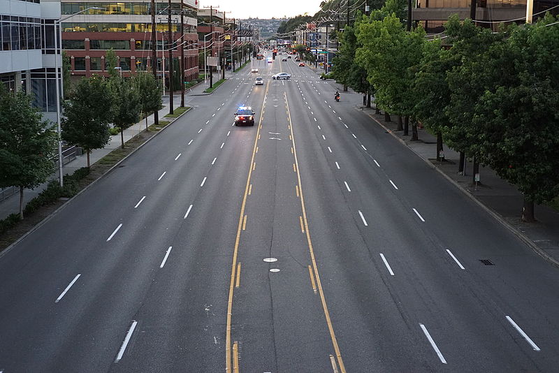
Elliott Avenue begins at Western Avenue and Lenora Street and goes 2⅕ miles northwest to halfway between W Galer Street and W Garfield Street, where it becomes 15th Avenue W.
Looking south down Elliott Avenue W at W Mercer Place, August 1921. Courtesy of the Seattle Municipal Archives, Identifier 1862
Born and raised in Seattle, Benjamin Donguk Lukoff had his interest in local history kindled at the age of six, when his father bought him settler granddaughter Sophie Frye Bass’s Pig-Tail Days in Old Seattle at the gift shop of the Museum of History and Industry. He studied English, Russian, and linguistics at the University of Washington, and went on to earn his master’s in English linguistics from University College London. His book of rephotography, Seattle Then and Now, was published in 2010. An updated version came out in 2015.
Like Queen Anne Avenue N, Queen Anne Boulevard is named for the neighborhood and hill, themselves named for the Queen Anne architectural style popular with builders in the 1880s. Unlike the avenue, though, the boulevard is not one single street, but a scenic loop incorporating many streets (and hence has no directional designation, such as Queen Anne Boulevard W).
The legislation establishing Queen Anne Boulevard was passed in 1907, and construction took place from 1911 to 1916. The Seattle Department of Transportation has had jurisdiction over the streets since 1942; jurisdiction over the landscaping remains with Seattle Parks and Recreation.
The loop is slightly over 3⅔ miles in length; the ordinance gives its route as follows (edited for style and current street names and directional designations, with notes added):
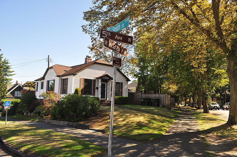
Extending from Prospect Street between Warren Avenue N and 2nd Avenue N, in a northeasterly direction*, to an intersection with Galer Street near Bigelow Avenue N; thence northerly following the general direction of Bigelow Avenue N as nearly as the contours of the ground will permit, to Wheeler Street; thence westerly to Nob Hill Avenue N; thence southerly to McGraw Street; thence westerly to 2nd Avenue N; thence northwesterly to Smith Street†, west of Warren Avenue N; thence westerly along Smith Street to a point east of 1st Avenue W; thence southerly to W McGraw Street and 2nd Avenue West‡; thence westerly to 3rd Avenue W; thence northwesterly to 5th Avenue W and W Smith Street§; thence northerly to W Raye Street; thence westerly to 8th Avenue W; thence northerly to W Armour Street; thence northwesterly to W Fulton Street; thence westerly to 9th Avenue W; thence southwesterly to 10th Avenue W and W Armour Street; thence southerly to W Wheeler Street; thence easterly to 8th Avenue W; thence southerly to W McGraw Street; thence easterly to 7th Avenue W; thence southerly to W Blaine Street; thence westerly to 8th Avenue W; thence southerly to W Lee Street; thence southeasterly to W Highland Drive and 7th Avenue West¶.
* Now the southern extension of Bigelow Avenue N. † Now McGraw Place. ‡ Now the east half of W McGraw Place. § Now the west half of W McGraw Place. ¶ Now 8th Place W.
Notably, there is a gap in the loop; Highland Drive between 7th Avenue W and Warren Avenue N could have made it closed, but this was not done.
“Queen Anne Boulevard, Seattle Historic Landmark” Parks Department sign, 1st Avenue W and W Smith Street, July 2015. Courtesy of the Seattle Municipal Archives, Identifier 178301
Queen Anne Boulevard at night: 8th Place W just north of Marshall Park, July 2015. Note the Wilcox Wall supporting the light fixtures. Courtesy of the Seattle Municipal Archives, Identifier 178303
Born and raised in Seattle, Benjamin Donguk Lukoff had his interest in local history kindled at the age of six, when his father bought him settler granddaughter Sophie Frye Bass’s Pig-Tail Days in Old Seattle at the gift shop of the Museum of History and Industry. He studied English, Russian, and linguistics at the University of Washington, and went on to earn his master’s in English linguistics from University College London. His book of rephotography, Seattle Then and Now, was published in 2010. An updated version came out in 2015.
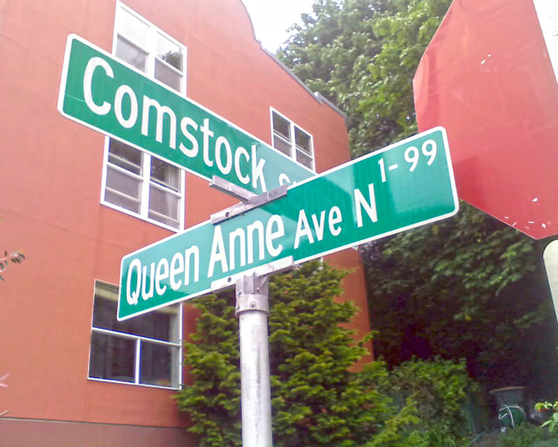
Originally Temperance Street and Villard Avenue, Queen Anne Avenue N was given its current name in 1895 as part of the Great Renaming. It was named after Queen Anne Hill and the Queen Anne neighborhood. Originally called Eden Hill or Galer Hill, they were themselves renamed after the Queen Anne architectural style that became popular in the 1880s.
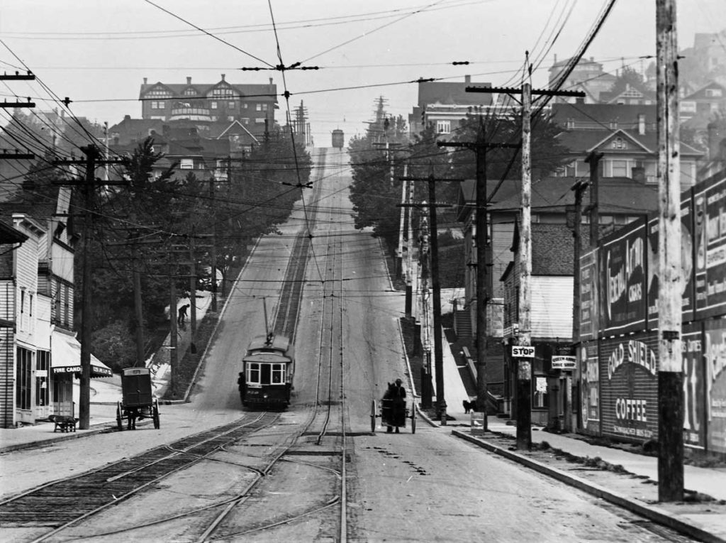
Looking north up the Counterbalance (Queen Anne Avenue N), 1910
Queen Anne Avenue begins at Western Avenue, less than 100 feet south of Denny Way, and becomes Queen Anne Avenue N as it crosses Denny. From there it goes 2⅕ miles north to Bertona Street and the Ship Canal Trail.
Born and raised in Seattle, Benjamin Donguk Lukoff had his interest in local history kindled at the age of six, when his father bought him settler granddaughter Sophie Frye Bass’s Pig-Tail Days in Old Seattle at the gift shop of the Museum of History and Industry. He studied English, Russian, and linguistics at the University of Washington, and went on to earn his master’s in English linguistics from University College London. His book of rephotography, Seattle Then and Now, was published in 2010. An updated version came out in 2015.
I wasn’t sure whether to label Van Buren Avenue a “paper street” or not. Unlike W Semple Street and Albert Place W, part of the right-of-way has actually been improved (see below). However, like those two streets, it is not signed; and unlike Semple, there are no buildings with Van Buren Avenue addresses. (There are two houses on the street, but one has a W Prospect Street address; the other, an Elliott Avenue W address.)
The right-of-way stretches from just southeast of W Prospect Street, northeast of Elliott Avenue W, to where the Magnolia Bridge onramp turns west at W Garfield Street. The first 350 or so feet are drivable. There is also a foot trail through the Southwest Queen Anne Greenbelt in the right-of-way, beginning at the east end of W Lee Street and heading southeast. Lastly, just under 600 feet of the Magnolia Bridge onramp is located in the right-of-way. It could conceivably be signed Van Buren Avenue W instead of W Galer Street Flyover, but this is not the case.
Born and raised in Seattle, Benjamin Donguk Lukoff had his interest in local history kindled at the age of six, when his father bought him settler granddaughter Sophie Frye Bass’s Pig-Tail Days in Old Seattle at the gift shop of the Museum of History and Industry. He studied English, Russian, and linguistics at the University of Washington, and went on to earn his master’s in English linguistics from University College London. His book of rephotography, Seattle Then and Now, was published in 2010. An updated version came out in 2015.
This street was named in 1895 for George Kinnear (1836–1912), the namesake of nearby Kinnear Park. Born in Ohio, he grew up first in Indiana, then Illinois. He fought for the Union during the Civil War and came to Seattle in 1878, his brother, John, following a few years later. During the time of anti-Chinese agitation, he was captain of the Home Guard that enforced the rule of law and prevented those who wished to expel Chinese laborers from doing so violently. His account of the events of February 1886 was published in the Seattle Post-Intelligencer in 1911 as “Anti-Chinese Riots at Seattle, Wn., February 8th, 1886.”
Born and raised in Seattle, Benjamin Donguk Lukoff had his interest in local history kindled at the age of six, when his father bought him settler granddaughter Sophie Frye Bass’s Pig-Tail Days in Old Seattle at the gift shop of the Museum of History and Industry. He studied English, Russian, and linguistics at the University of Washington, and went on to earn his master’s in English linguistics from University College London. His book of rephotography, Seattle Then and Now, was published in 2010. An updated version came out in 2015.
All in one year John McGraw was Chief of Police, Marshall, Sheriff, Harbor Master and Fire Warden. Later he was Governor of Washington and in between, bank president and attorney-at-law — quite a career.
The second governor of Washington after statehood (1893–1897), he had been King County sheriff during the anti-Chinese riots of 1886. He defended Chinese laborers from the mob that was trying to expel them from the city, although, according to The Role of Federal Military Forces in Domestic Disorders, 1877–1945, he initially sympathized with the rioters and allowed them to force the Chinese (without physically harming them) to the waterfront to be loaded onto the steamship Queen of the Pacific. Both he and Mayor Henry Yesler lost their bids for re-election that summer in what the book calls “a resounding show of support for anti-Chinese forces.”
John H. McGraw
Today, W McGraw Street begins as a shoreline street end on Elliott Bay in Magnolia west of Perkins Lane W. It begins in earnest at the intersection of Westmont Way W, Montavista Place W, and Rosemont Place W and goes ⅘ of a mile east to 24th Avenue W, forming the heart of Magnolia Village, the neighborhood’s commercial district, from 35th Avenue W to 32nd Avenue W. It resumes on the other side of Interbay in Queen Anne, beginning at 11th Avenue W and going 1⅛ miles east to the Northeast Queen Anne Greenbelt east of Bigelow Avenue N. There are a few block-long segments heading down the hill to Westlake and, like Blaine Street, a right-of-way platted into Lake Union that serves as a driveway and affords no actual lake access.
E McGraw Street doesn’t appear again until 15th Avenue E and Boyer Avenue E in Montlake, where it goes ⅔ of a mile east to 26th Avenue E at the west end of the Washington Park Arboretum, becoming a stairway for a short distance just before 19th Avenue E. It ends for good in Madison Park as a two-block stretch between 38th Avenue E and 40th Avenue E.
Born and raised in Seattle, Benjamin Donguk Lukoff had his interest in local history kindled at the age of six, when his father bought him settler granddaughter Sophie Frye Bass’s Pig-Tail Days in Old Seattle at the gift shop of the Museum of History and Industry. He studied English, Russian, and linguistics at the University of Washington, and went on to earn his master’s in English linguistics from University College London. His book of rephotography, Seattle Then and Now, was published in 2010. An updated version came out in 2015.
Unfortunately, though the Blaines may have been feminists, they, according to HistoryLink.org, had no love for Native Americans (or, for that matter, the Irish). Their departure in 1856 was prompted by the Battle of Seattle. Junius Rochester writes:
On January 20, 1856, a son John, was born to Catharine and David Blaine. Six days later the Battle of Seattle erupted. David had duty at one of the blockhouses, but managed to get Catharine and their babe aboard the Decatur in Elliott Bay. David had described the Indians as a “poor degraded race,” which would “soon disappear.” Catharine compared their “stupidity and awkwardness” to that of the Irish. The Indian uprising confirmed their worst fears and prejudices.
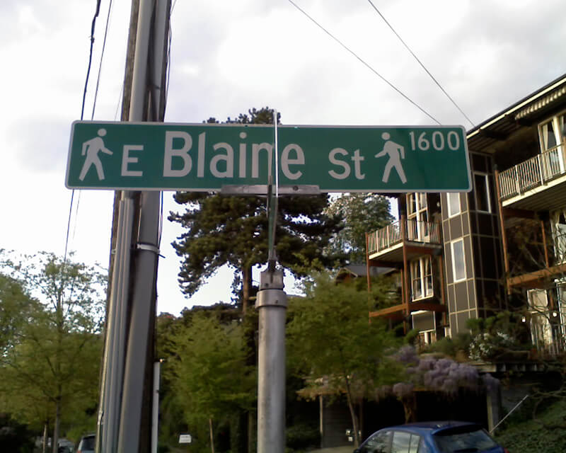
Today, W Blaine Street begins in Magnolia at 36th Avenue W and goes a semicircular ⅕ of a mile to 34th Avenue W and W Howe Street. It resumes at 31st Avenue W and goes almost ⅓ of a mile to Thorndyke Avenue W. There is a stub of W Blaine east of 15th Avenue W that is quickly stopped by the Southwest Queen Anne Greenbelt. The street resumes at 12th Avenue W and goes just over a mile to 4th Avenue N, having briefly become a stairway at 9th Avenue W. After a series of short stretches serving as driveways and parking, the Blaine Street right-of-way resurfaces east of Westlake Avenue N and heads into Lake Union. Here, too, it serves as a driveway and offers no access to the water. East of Lake Union, E Blaine Street begins at Fairview Avenue E and goes ⅛ of a mile to Franklin Avenue E, where it becomes part of the I-5 Colonnade park underneath the freeway. From Lakeview Boulevard E to just west of 10th Avenue E it is a stairway, and then two blocks of roadway ending at 12th Avenue E and Lake View Cemetery. There is then a diagonal ¼-mile stretch from 19th Avenue E to E Howe Street in Montlake. E Blaine finishes up as a ⅕-mile stretch from 37th Avenue E to McGilvra Boulevard E and a final two-block run from E Madison Street to 43rd Avenue E, both in Madison Park.
Born and raised in Seattle, Benjamin Donguk Lukoff had his interest in local history kindled at the age of six, when his father bought him settler granddaughter Sophie Frye Bass’s Pig-Tail Days in Old Seattle at the gift shop of the Museum of History and Industry. He studied English, Russian, and linguistics at the University of Washington, and went on to earn his master’s in English linguistics from University College London. His book of rephotography, Seattle Then and Now, was published in 2010. An updated version came out in 2015.
In the early 1870s, the Denny and Mercer families gradually began to systematically subdivide their large land holdings on the south and east slopes of Queen Anne Hill. When a severe windstorm blew down thousands of trees in the north district in 1875, views opened up and land seekers turned their attentions beyond Belltown. Real estate speculators new to the territory arrived and began to buy up property on the crest of Queen Anne Hill. Some of these speculators also became developers, such as George Kinnear, or builder-developers, such as Isaac Bigelow.
Though its proximity to Boston and Lynn Streets suggest a tribute to Newton, Massachusetts, neither the Georges nor the Bigelows appear to have a connection to the state, so it seems this one should be chalked up to Isaac Bigelow’s middle name.
Today, Newton Street begins in Magnolia as W Newton Street at 30th Avenue W, and goes nearly half a mile east to 23rd Avenue W. There is then a two-block stretch from 15th Avenue W to 13th Avenue W in Interbay, and then the “original” Newton Street, which stretches almost a half mile from 1st Avenue N to Taylor Avenue N, followed by another two-block stretch from Dexter Avenue N to just past 8th Avenue N. On the east side of Lake Union, E Newton Street picks up again at Terry Pettus Park, just west of Fairview Avenue E, and goes ¼ mile to Boylston Avenue E and Lakeview Boulevard E. There follows another ¼-mile stretch from Broadway E to Everett Avenue E. East of there, Newton exists in a number of short segments through Montlake, and then enjoys a run of ⅓ of a mile from 37th Place E to 43rd Avenue E in Madison Park.
Born and raised in Seattle, Benjamin Donguk Lukoff had his interest in local history kindled at the age of six, when his father bought him settler granddaughter Sophie Frye Bass’s Pig-Tail Days in Old Seattle at the gift shop of the Museum of History and Industry. He studied English, Russian, and linguistics at the University of Washington, and went on to earn his master’s in English linguistics from University College London. His book of rephotography, Seattle Then and Now, was published in 2010. An updated version came out in 2015.


