Dibble Avenue NW

This street was created in 1890 as part of F.D. Dibble’s First Addition to Ballard, which had just incorporated as a city that year, and would be annexed to Seattle 17 years later. It would, therefore, seem to be named after F.D. Dibble. But who was he? And who was J. Albert Jackson, who filed the plat?

Jackson first. The December 2, 1912, issue of The Sacramento Union refers to him as former vice president of the Washington-Alaska Bank of Nevada (based in Fairbanks). He was charged with falsifying the failed bank’s books and aiding and abetting its receiver, Frank W. Hawkins, in embezzlement. So much for his good name, which was used in one of the advertisements for the addition: “Title absolutely perfect; title comes from a bank president in Seattle.”

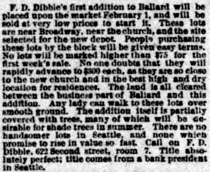
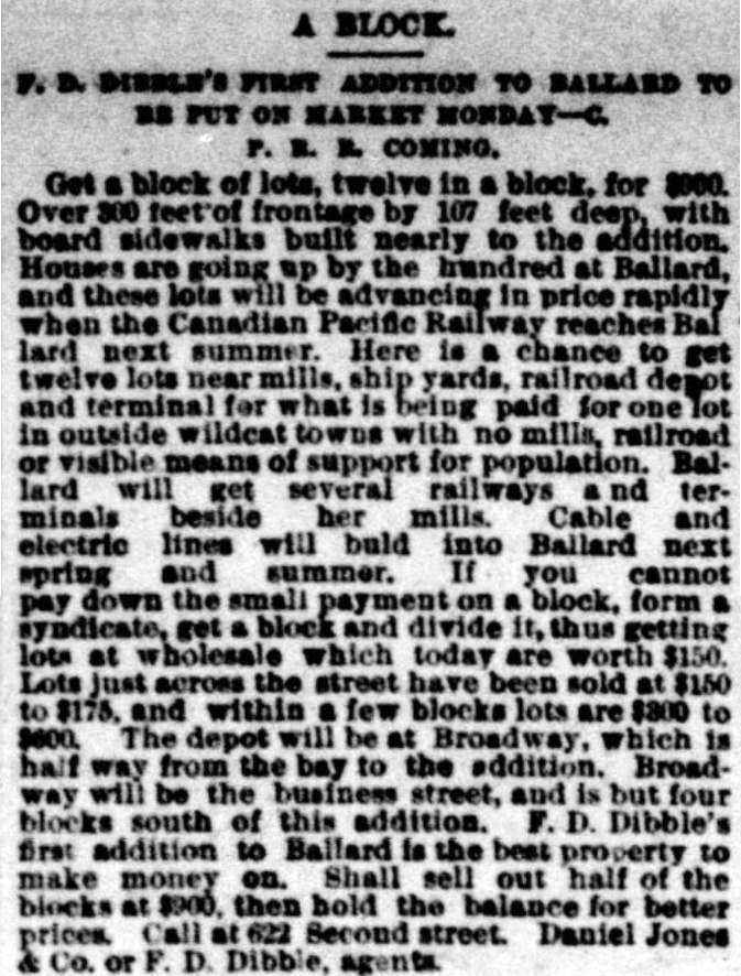
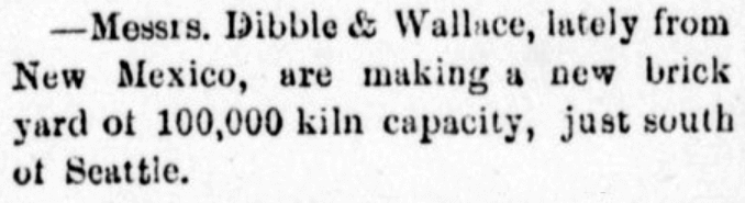
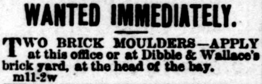
I was able to find out even less about F.D. Dibble. He appears to have been associated with Daniel Jones & Co., who were involved in the development of Mount Baker Park (see Hunter Boulevard S for more on Jones). But that’s it. I was able to find two mentions of Dibble & Wallace, a brick manufacturing company, which opened in 1882, but no first names of either proprietor. Dibble may have been F.D., or a relative — it’s impossible to say.

I also came across a book, Prairie Poems and Others, written by an F.D. Dibble and published in 1900. There is no biographical information included, but this Dibble plainly had been to Washington: among the many poems are “Lake Pend d’Oreille, Washington,” “Mt. Rainier,” and “Rainy Days in Seattle.” Could this have been the real estate man? Again — impossible to say.

Rainy Days in Seattle, poem by F.D. Dibble, published 1900: Down pours the rain without refrain / As though 'twould never cease again. / The heavens weep, the waters creep, / Drizzle, drizzle, waters sweep / Adown the mud-encumbered street; / But it lacks the power to drown / The old-time liars of the town, / Who vow they never saw before, / In all past time, so much downpour.
“Rainy Days in Seattle,” poem by F.D. Dibble (1900)

We must leave it at this, then: Dibble Avenue NW was named for F.D. Dibble… full stop.

Today, Dibble Avenue NW begins at NW 65th Street and goes 1½ miles north to NW 95th Street. It begins again on the other side of Holman Road NW at NW 97th Street and goes ⅓ of a mile north to NW 105th Street.

Street sign at NW 67th Street and Dibble Avenue NW, Seattle, October 12, 2021
Street sign at NW 67th Street and Dibble Avenue NW, Seattle. Photograph by Benjamin Lukoff, October 12, 2021. Copyright © 2021 Benjamin Lukoff. All rights reserved.

Alonzo Avenue NW

This street was named for Alonzo Hamblet (1863–1937), son of Eli (1820–1905) and Mary Booth Hamblet (1840–1905), namesake of Mary Avenue NW. According to an article in the November 19, 1937 issue of The Seattle Times, the Hamblets had their homestead where Ballard High School is today. Alonzo was one of the men behind the West Coast Improvement Company that developed Ballard (then known as Gilman Park).

Alonzo Avenue NW begins at NW 67th Street just north of the high school and goes ⅖ of a mile to NW 75th Street.

Street sign at NW 67th Street and Alonzo Avenue NW, Seattle, October 12, 2021
Street sign at NW 67th Street and Alonzo Avenue NW, Seattle. Photograph by Benjamin Lukoff, October 12, 2021. Copyright © 2021 Benjamin Lukoff. All rights reserved.

Mary Avenue NW

This street was named for Mary Booth Hamblet (1840–1905), wife of Eli (1820–1905) and mother of Alonzo (1863–1937), namesake of Alonzo Avenue NW. The Hamblets were early Ballard settlers, and according to an article in the November 19, 1937 issue of The Seattle Times had their homestead where Ballard High School is today.

Street sign at NW 67th Street and Mary Avenue NW, Seattle, October 12, 2021
Street sign at NW 67th Street and Mary Avenue NW, Seattle. Photograph by Benjamin Lukoff, October 12, 2021. Copyright © 2021 Benjamin Lukoff. All rights reserved.

Mary Avenue NW begins at NW 67th Street just north of the high school and goes nearly 2 miles to the NW 105th Street right-of-way, where it becomes a trail leading to Carkeek Park. As I wrote in NW Blue Ridge Drive,

Ten or so years ago I saw a Private Property sign at the trailhead, put up by the Blue Ridge Club, but it was gone the next time I visited — I can’t remember if I complained or someone else did. (The woods are private, but the trail is Mary Avenue NW right-of-way.) This wasn’t in the original plat, but according to an old Flickr chat I had with Andreas “Severinus” Breuer, “there was apparently a WPA project approved to install a 30′-wide gravel road between 100th and 110th (apparently now NW Carkeek Park Road).… I imagine the ravine would look quite different if a 30′ gravel road had been put in, so presumably this plan wasn’t carried out. But a 1940 engineering map shows a surveyed ROW from 105th to the Carkeek border, and in Carkeek there seems to be a route that follows the WPA route (Clay Pit Trail > Hillside Trail > Brick Road Trail > Road). Perhaps the trail that exists today was made by the original surveyors or by WPA men?”

Division Avenue NW

Division, like Front, is usually a name applied to a major street, like Division Street in Chicago, or to a street that divides one section of town from another, like Division Street in Manhattan, or to a street that does both, like Division Street in Spokane. But in Seattle, Division Avenue NW goes only two blocks, from NW 65th Street to NW 70th Street, and doesn’t appear to serve as any sort of dividing line at all. Why is this?

My friend Rob Ketcherside, a local historian, put together this helpful database of and article on old Ballard street names, which got me on the right track. But what helped me figure out this riddle — at least I think I have — was this 1903 sewer map that Rob consulted and linked to. A portion of it appears below.

Portion of map of Ballard sewers, 1903, covering present-day intersection of Division Avenue NW and NW 65th Street
Portion of map of Ballard sewers, 1903, covering present-day intersection of Division Avenue NW and NW 65th Street. Courtesy of the Seattle Municipal Archives, Identifier 1588.

The CITY to the right of Division Avenue N just north of E Ship Street is actually part of BALLARD CITY BOUNDARY, which ran along what is today 8th Avenue NW… except between E Ship Street (65th) and E Sloop Street (70th). The boundary continued in a straight line, but Division Avenue jogged to the west, causing the boundary to go down the center of those two blocks. It appears that 8th Avenue NW was later put straight through (I’m not sure exactly when, but this Baist atlas plate from 1912 appears to have the extension penciled in), but the jog was never renamed to something like 8th Place NW.

And that’s — I think — how you get a two-block–long Division Avenue that doesn’t divide anything!

Street sign at NW 65th Street and Division Avenue NW, October 2021
Street sign at NW 65th Street and Division Avenue NW, Seattle. Photograph by Benjamin Lukoff, October 12, 2021. Copyright © 2021 Benjamin Lukoff. All rights reserved.