Yesler Way

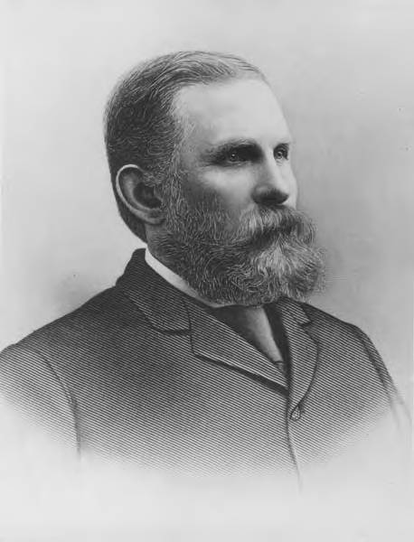
This street is named after Henry Leiter Yesler (1810–1892). Originally from Leitersburg, Maryland, which was founded by his great-grandfather, and living in Massillon, Ohio, before coming west, he moved to Seattle from Portland, Oregon, in 1852. As John Caldbick writes for HistoryLink.org:

…[Yesler] quickly established himself as the most important resident of the rain-swept little spot that would soon become Seattle. He had the first steam-powered sawmill on Puget Sound up and running within months, and for several years he employed almost every male settler in Seattle and a considerable number of Native Americans. His mill was early Seattle’s only industry, and without it the town’s development would have been greatly delayed.

Carson Dobbins Boren and David Swinson “Doc” Maynard had already claimed land on Elliott Bay either side of what is today Pioneer Square, but they gave him part of their claims so he could access the water from the claim he made farther up First Hill. Yesler’s mill was built at the foot of what is now Yesler Way but was originally Mill Street, also known as Skid Road — and yes, Seattle may be where the term originated, referring to a neighborhood largely inhabited by the “down and out.”

Yesler was also King County auditor in 1852, and Seattle mayor from 1874 to 1875 and 1885 to 1886.

Yesler had two children: a son, Henry George Yesler (1845–1859), by his wife, Sarah Burgert Yesler (1822–1887); and a daughter, Julia Benson Intermela (1855–1907). Her mother wasn’t Sarah, who didn’t come to Seattle until 1858, but rather a Duwamish woman named Susan, daughter of Salmon Bay Curley (Su-quardle), who had worked at Yesler’s mill. When Sarah finally joined her husband, he sent Susan and Julia to live with Jeremiah S. Benson, a cook at the mill. In the 1870 territorial census, Julia is listed as living with the Bensons, but the next year she is listed as a HB (“half-breed”) house servant for the Yeslers. Unlike Rebecca Lena Graham, who successfully sued the relatives of Franklin Matthias to be recognized as his rightful heir, Julia inherited nothing when her father died in 1892. Even so,

…The settlement of Henry Yesler’s estate was an imbroglio of epic proportions. It pitted Minnie Gagle Yesler [a younger cousin whom he married a few years before his death] and her mother against James Lowman [his nephew] and municipal authorities, who believed that Yesler had made a will that left most of his fortune, by then worth more than $1,000,000, to the city, hoping thereby to cement his reputation as the “Father of Seattle.”

Yesler is also quoted as anticipating “Strange Fruit” by 55 years… though it’s by no means a sentiment Abel Meeropol or Billie Holiday would have shared. In January 1882, a mob lynched James Sullivan, William Howard, and Benjamin Paynes between two of his maple trees. Harper’s Weekly reported Yesler’s reaction: “That was the first fruit them trees ever bore, but it was the finest.”

Henry L. Yesler
Henry L. Yesler. Courtesy of the Seattle Municipal Archives, Identifier 12257

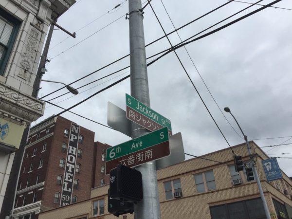
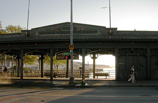
Yesler Way begins on the Elliott Bay waterfront at Alaskan Way and goes 2⅙ miles east to Leschi Park, just past 32nd Avenue. It also appears just west of Lake Washington Boulevard, where it goes about 200 feet west and essentially serves as a driveway for a couple of houses.

Yesler Way, which becomes E Yesler Way east of Broadway, also divides three of the city’s directional designation zones from each other. South of Yesler, east–west streets carry the S prefix and north–south avenues carry the suffix S. North of Yesler, north–south avenues carry no suffix; east–west streets carry the E prefix east of Broadway and no prefix west of Broadway.

Street sign at corner of Yesler Way and Broadway, August 25, 2009
Street signs at corner of Yesler Way and Broadway, August 25, 2009. Photograph by Benjamin Lukoff. Copyright © 2009 Benjamin Lukoff. All rights reserved.

Terry Avenue

This street is named after Charles Carroll Terry (1830–1867), one of the members, along with his older brother, Lee, of the Denny Party that landed at Alki Point in November 1851. Shortly after the landing, he opened the first store in King County. Lee had made a land claim in Alki a few months earlier, but went home to New York the next year; Charles remained, even after most of the other settlers left for what is now Pioneer Square. It seems he finally moved north in 1857, trading his Alki land for that of David Swinson “Doc” Maynard in Pioneer Square. He died 10 years later, according to this biography, of tuberculosis. (Whether or not he and his brother were responsible for naming the Alki Point settlement New York, which became New York–Alki [the latter word meaning ‘by and by’ or ‘someday’ in Chinook Jargon] and then just Alki, is unclear, although he did officially apply the Alki name to the town plat he filed in 1853.)

In 1855, he, along with Edward Lander, bought Carson Boren’s downtown land claim for $500; he and Lander donated two acres to form the first campus of the University of Washington, which opened in 1861. (He named one of his sons, born in 1862, Edward Lander Terry.) His name also appears on Terry Hall, a UW dormitory on NE Campus Parkway.

Charles C. Terry
Charles Carroll Terry

Terry Avenue begins at Alder Street on First Hill and goes ½ a mile to Spring Street, where it is blocked by Virginia Mason Hospital. Resuming at Seneca Street, it goes ⅕ of a mile to Pike Street. On the other side of Interstate 5 and the Washington State Convention Center, it begins again at Howell Street and goes ⅘ of a mile to Valley Street and Lake Union Park, becoming Terry Avenue N as it crosses Denny Way. Amazon.com’s headquarters are at 410 Terry Avenue N, between Harrison Street and Republican Street.

Minor Avenue

This street is named for Dr. Thomas Taylor Minor (1844–1889), who came to Seattle in 1883 from Port Townsend, where he had lived since 1868 and whose mayor he had been in 1880 and 1881. He was one of the founders of the Seattle, Lake Shore and Eastern Railway in 1885 and became mayor of Seattle from 1887 to 1889. He drowned off Whidbey Island while on a duck-hunting trip on December 2, 1889. The other fatalities were George Morris Haller, brother of Theodore Haller for whom Haller Lake is named, and his brother-in-law, Lewis Cox.

Thomas Taylor Minor
Dr. Thomas Taylor Minor

Minor Avenue begins at Broadway just north of Jefferson Street and goes ⅔ of a mile northwest to Pine Street. Resuming on the other side of Interstate 5 at Olive Way, it goes another ⅔ of a mile northwest, then north, to Mercer Street, having become Minor Avenue N north of Denny Way. After a two-block stretch from Roy Street to Aloha Street, it appears again as Minor Avenue E at E Newton Street, and goes nearly ½ a mile to its end at E Roanoke Street.

Sign at corner of E Boston Street and Minor Avenue E, September 1, 2010
Signs at corner of E Boston Street and Minor Avenue E, September 1, 2010. Photograph by Benjamin Lukoff. Copyright © 2010 Benjamin Lukoff. All rights reserved.

Terrace Street

This street — named Pine Street in Terry’s Second Addition to the Town of Seattle, filed in 1872 — was renamed Terrace in 1876, presumably to avoid duplicating the Pine Street to the north. My assumption is it was given this name because of how steep First Hill is at this point — Paul Dorpat, writing for HistoryLink, says “Except at Terrace Street on the south and near Union Street on the north, the hill was readily negotiable first by hikers and later by street graders and trolley tracks.” One can see in the image below the long, steep stairway in the Terrace Street right-of-way “from 5th Avenue east to beyond 7th Avenue,” as Dorpat writes on his own blog.

Official from Seattle Weights and Measures Division with confiscated scales standing in Terrace Street
Seattle Weights and Measures Division officials standing with confiscated scales in Terrace Street, 1917. Note long stairway in upper-right corner. Courtesy of the Seattle Municipal Archives, Identifier 1210.

Today, Terrace Street begins at Yesler Way above 4th Avenue and goes a block and a half up the hill before being blocked by Interstate 5. It resumes just east of Harborview Medical Center and goes ⅓ of a mile east to 12th Avenue. There is another short stretch of E Terrace Street from 20th Avenue to 23rd Avenue by Garfield High School, and then a final ½ mile from 30th Avenue to Lake Washington Boulevard in Leschi, the portion between 36th Avenue and Randolph Avenue being a stairway.

Boren Avenue

This street was named for Carson Dobbins Boren (1824–1912), a member of the Denny Party that landed at Alki Point in November 1851. His sisters Mary Ann (1822–1910) and Louisa (1827–1916) married brothers Arthur (1822–1899) and David Denny (1832–1903) in 1843 and 1853, respectively. These weren’t the only Boren–Denny connections, either: his mother, Sarah Latimer Boren (1805–1888), who had been widowed in 1827, married John Denny (1793–1875) — Arthur and David’s father — in 1848. (Their mother, also named Sarah, had died in 1841.)

Boren is said to have built the first cabin in Seattle, at what is now 2nd Avenue and Cherry Street, in April 1852. He was elected King County’s first sheriff the same year. Boren’s land claim of 320 acres covered what is today a rectangle approximately bounded by (going clockwise) Yesler Way, 15th Avenue, E Cherry Street and its projection west, and Western Avenue and its projection north, but he sold it for $500 to Charles Terry and Edward Lander in 1855.*

* “Its projection” is necessary here because of Boren and Arthur Denny’s decision to have their street grid follow the shoreline, while “Doc” Maynard preferred his to follow the cardinal directions; Maynard’s grid eventually extended through the entire city and, indeed, county. (See “Seattle’s first streets.”) The actual southern boundary is a bit north of Yesler Way since both Boren and Maynard adjusted their initial claims to give Henry Yesler land to build and supply his sawmill.

Why Boren sold his land isn’t entirely clear. Sophie Frye Bass writes in Pig-Tail Days in Old Seattle that he sold it “early at a great sacrifice and became a roamer and, therefore, did not share in the up-building of the town”; her sister, Roberta Frye Watt, is indirectly quoted by Junius Rochester thus: “Carson had an unhappy home life. This compelled him to move deeper and deeper into the forest; to hunt and dream; and to shed most of his possessions.” Indeed, he and his wife, Mary Ann, divorced in 1861.

Carson Dobbins Boren, photographer and date unknown
Carson Dobbins Boren

Today, Boren Avenue S begins at 14th Avenue S, Rainier Avenue S, and S Jackson Street, and goes 2⅕ miles north to Valley Street and Lake Union Park, becoming Boren Avenue as it crosses Yesler Way and Boren Avenue N as it crosses Denny Way. It is one of the few north–south streets in Seattle to have three directional designations.

E Spruce Street

This street, like Alder Street and Fir Street — all, of course, named for trees — originates in the 1872 plat of Terry’s Second Addition to the Town of Seattle, filed by Arthur Armstrong Denny, Henry Leiter Yesler, Erasmus Smithers, and Franklin Matthias, the last two as executors of the estate of Charles Carroll Terry, who was part of the Denny Party of settlers in 1851, and died in 1867. However, it was originally named Cedar Street (duplicative of another in Belltown). It received its current name as part of the Great Renaming of 1895, when Cedar Street, Prince William Street, and Erie Street were all changed to Spruce.

Today, E Spruce Street begins at Broadway and goes nearly a mile east to 25th Avenue, only interrupted once, at Boren Avenue, which it connects to as a pair of stairways. It resumes at 28th Avenue and goes just over ¼ of a mile to Lake Dell Avenue (the portion from Peppi’s Playground through Peppi’s Woods as a stairway). Farther east, there is a couple-hundred-foot-long section at the west end of Euclid Avenue, and then a longer one — almost ⅒ of a mile — from near the east end of Euclid Avenue to E Alder Street. (Its complicated end is the result of platted streets not always matching up with topography, or with where people actually ended up building roads.)

Portion of King County Parcel Viewer showing E Spruce Street right-of-way from Lake Dell Avenue to E Alder Street along with Euclid Avenue
King County Parcel Viewer showing E Spruce Street right-of-way from Lake Dell Avenue in the west to E Alder Street in the east. Instead of the eastern portion of Spruce connecting directly to the western portion, there is a gap; instead, the western portion connects to Euclid Avenue by going through private property.

Fir Street

This street, like nearby Alder Street — both, obviously, named for trees — originates in the 1872 plat of Terry’s Second Addition to the Town of Seattle, filed by Arthur Armstrong Denny, Henry Leiter Yesler, Erasmus Smithers, and Franklin Matthias, the last two as executors of the estate of Charles Carroll Terry, who was part of the Denny Party of settlers in 1851, and died in 1867.

Today, Fir Street begins where 8th Avenue and 9th Avenue meet, a block south of Harborview Medical Center. From there to its end at Martin Luther King Jr. Way 1⅕ miles to the east, it is almost completely uninterrupted, except for the portion west of 11th Avenue being blocked by a retaining wall at Boren Avenue.

Alder Street

This street originates in the 1872 plat of Terry’s Second Addition to the Town of Seattle, filed by Arthur Armstrong Denny, Henry Leiter Yesler, Erasmus Smithers, and Franklin Matthias, the last two as executors of the estate of Charles Carroll Terry, who was part of the Denny Party of settlers in 1851, and died in 1867. (In 1857, Matthias was listed as being a carpenter, originally from Indiana, Pennsylvania; not too long thereafter, he apparently married and had a child with the daughter of Shilshole Curley [native name Saxkla’xid{?}], “head-man” of the shill-shohl-AHBSH village at šilšul on Salmon Bay. This child, Rebecca Lena Graham, later had to sue Matthias’s relatives to be recognized as his rightful heir. You can read more about her on the Yale University Press blog, at Fitz-Henry Family History, and in the Pacific Northwest Quarterly.)

Today, Alder Street begins at the south entrance to the Harborview Medical Center parking garage, its original first few blocks having been obliterated by Interstate 5, and goes ⅓ of a mile northeast and then east to the Children and Family Justice Center at 12th Avenue.* It resumes at 14th Avenue and goes just over a mile to 32nd Avenue. Finally, just west of 35th Avenue, the Lake Dell Avenue arterial becomes E Alder Street, which snakes ⅕ of a mile down the hill to end at Lake Washington Boulevard. It was originally part of a group of streets named after trees — Pine, Alder, Cedar, and Fir — though Pine and Cedar have since become Terrace and Spruce, since they duplicated street names in other parts of Downtown.

* The Alder Street right-of-way technically begins at Yesler Way just west of 6th Avenue, but is unimproved and indistinguishable from the adjacent open space, and the Interstate 5 right-of-way begins on the east side of 6th.

S Jackson Street

Jackson Street was another one of the first streets platted in Seattle by David Swinson “Doc” Maynard in May 1853. It, like King, Lane, and Weller Streets, was named after a prominent Democratic politician — in this case Andrew Jackson, president of the United States from 1829 to 1837. Because of his history as a slaveholder and a proponent of Indian removal, there have been calls to at least symbolically change the street’s namesake to another Jackson, if not change the name outright.

S Jackson Street begins today at Alaskan Way S on the Elliott Bay waterfront and has an uninterrupted 2-mile run as an arterial to 31st Avenue S in Leschi. On the other side of Frink Park, it makes its way the few remaining blocks to Lake Washington as a minor arterial, then a staircase, then a minor street, and finally a shoreline street end, part of the String of Pearls.

Bilingual (Japanese and English) street sign at corner of 6th Avenue S and S Jackson Street
Bilingual (Japanese and English) street sign at corner of 6th Avenue S and S Jackson Street. Photograph by Stephen Fesler, The Urbanist, licensed under Creative Commons Attribution-NonCommercial-ShareAlike 4.0 International

S Washington Street

Washington Street was one of Seattle’s first streets, platted on May 23, 1853 by David Swinson “Doc” Maynard and named after President George Washington. Its initial segment begins at Alaskan Way S on the Elliott Bay waterfront and ends half a mile to the east at Kobe Terrace Park. East of Interstate 5 it exists in a number of segments interrupted by schools and parks and finally ends at S Frink Place and Frink Park.

Washington Street Boat Landing, September 2007, by Joe Mabel
Washington Street Public Boat Landing, September 2007. Photograph by Joe Mabel, Wikimedia Commons, licensed under Creative Commons Attribution-Share Alike 3.0 Unported

James Street

James Street, one of the first streets platted in Seattle on May 23, 1853, was named by Arthur Armstrong Denny after his younger brother, James Marion Denny (1824–1854). Histories of Seattle report that James was too sick to leave Oregon and come to Puget Sound with the Denny Party and, indeed, he died in the town of Sublimity, Oregon, just a year after the street was named for him. Nothing I have found reports an actual cause of death. Marion Street is also named after this brother.

James Street runs ¾ of a mile from Yesler Way just east of 1st Avenue to an alley just east of Broadway. It appears east of there in a few short stretches and finally as a stairway from 38th Avenue to Lake Washington Boulevard at Madrona Park.

Seattle’s first streets

The Denny Party landed at Alki Beach on November 13, 1851, and moved to dzidzəlalič  (today known as Pioneer Square) in the spring of 1852. The name “Seattle,” according to local historian Rob Ketcherside, first appeared in print that October. But it wasn’t until May 23, 1853, that David Swinson Maynard, Carson Dobbins Boren, and Arthur Armstrong Denny filed the first plats of the Town of Seattle — thereby creating its first official streets.

Boren and Denny famously aligned their streets with the Elliott Bay shoreline (32° west of north, or very close to northwest by north), while Maynard aligned his with the cardinal directions.

Plat of the Town of Seattle, May 23, 1853, by Carson Dobbins Boren and Arthur Armstrong Denny
Plat of the Town of Seattle, King County, Washington Territory, May 23, 1853, by David Swinson Maynard

Mill Street, which divided the two plats, was renamed Yesler Avenue in 1888, and Yesler Way — its current name — seven years later. Front Street became 1st Avenue and Commercial Street became 1st Avenue S as part of that same “Great Renaming” ordinance of 1895. Streets that were named in these first plats that have kept their names till today include:

Boren and Denny

  • James Street — after James Marion Denny, younger brother of A.A. Denny
  • Cherry Street — after Cherry Grove, Illinois, where the Denny Party’s journey to Seattle began
  • Columbia Street
  • Marion Street — also after James Marion Denny
  • Madison Street — after President James Madison
  • Spring Street — after the springs along Elliott Bay

Mill Street is now Yesler Way, and Front Street is now 1st Avenue.

Maynard

  • Washington Street — after President George Washington
  • Main Street
  • Jackson Street — after President Andrew Jackson
  • King Street — after Vice President William Rufus DeVane King
  • Weller Street — after John B. Weller, senator from California, later governor of California
  • Lane Street — after Joseph Lane, governor of Oregon Territory, later Southern Democratic candidate for vice president in the 1860 election

Commercial Street is now 1st Avenue S.