Born and raised in Seattle, Benjamin Donguk Lukoff had his interest in local history kindled at the age of six, when his father bought him settler granddaughter Sophie Frye Bass’s Pig-Tail Days in Old Seattle at the gift shop of the Museum of History and Industry. He studied English, Russian, and linguistics at the University of Washington, and went on to earn his master’s in English linguistics from University College London. His book of rephotography, Seattle Then and Now, was published in 2010. An updated version came out in 2015.
This street runs not quite 300 feet from Martin Luther King Jr. Way S in the east to 42nd Avenue S in the west, just south of S Henderson Street. Like nearby Valdez Avenue S and Yukon Avenue S, it was established in 1905 as part of Dunlap’s Supplemental to the City of Seattle, and, in keeping with the Alaska theme, was named after the city of Fairbanks, which had been founded just four years earlier. (Fairbanks itself was named after Indiana Senator Charles Warren Fairbanks [1897–1905], who was vice president under Theodore Roosevelt from 1905 to 1909.)
Born and raised in Seattle, Benjamin Donguk Lukoff had his interest in local history kindled at the age of six, when his father bought him settler granddaughter Sophie Frye Bass’s Pig-Tail Days in Old Seattle at the gift shop of the Museum of History and Industry. He studied English, Russian, and linguistics at the University of Washington, and went on to earn his master’s in English linguistics from University College London. His book of rephotography, Seattle Then and Now, was published in 2010. An updated version came out in 2015.
This very short street (375 feet long) in the Dunlap neighborhood runs from Spear Place S in the south to S Henderson Street in the north. Like Valdez Avenue S, which it intersects, it was established in 1905 as part of Dunlap’s Supplemental to the City of Seattle, and was named after the Yukon River, likely due to the recent Klondike Gold Rush (ended 1899).
Yukon Avenue S, incidentally, holds the distinction of being the at the very end of the list of Seattle streets taken in alphabetical order — hence the tagline for Streets of Seattle, a blog from 2012 that sadly never seems to have gotten off the ground: “Seattle street names, from Adams to Yukon.”
Born and raised in Seattle, Benjamin Donguk Lukoff had his interest in local history kindled at the age of six, when his father bought him settler granddaughter Sophie Frye Bass’s Pig-Tail Days in Old Seattle at the gift shop of the Museum of History and Industry. He studied English, Russian, and linguistics at the University of Washington, and went on to earn his master’s in English linguistics from University College London. His book of rephotography, Seattle Then and Now, was published in 2010. An updated version came out in 2015.
This short street (just ⅛ of a mile long) connects Martin Luther King Jr. Way S to Yukon Avenue S in Seattle’s Dunlap neighborhood. Established in 1905 as part of Dunlap’s Supplemental to the City of Seattle, it was named after Valdez, Alaska, which was itself named after Spanish naval officer Antonio Valdés y Fernández Bazán. (Other streets in the plat include the above-mentioned Yukon Avenue as well as Tanana Drive, Fairbanks Drive, and Rampart Drive. Tanana Drive is now part of S Henderson Street; Fairbanks Drive is now S Fairbanks Street; and Rampart Drive is now part of S Director Street.)
I haven’t been able to find a specific connection the Hulbert or Dunlap families might have with Alaska, but 1905 was just six years after the Klondike Gold Rush ended, and just four years before the Alaska–Yukon–Pacific Exposition. Seattle’s population went from 42,837 in 1890 to 80,671 in 1900 — an increase of 88% — and much of this was due to its central role in the gold rush as “the premier supply centre and the departure point for the gold fields.”
Born and raised in Seattle, Benjamin Donguk Lukoff had his interest in local history kindled at the age of six, when his father bought him settler granddaughter Sophie Frye Bass’s Pig-Tail Days in Old Seattle at the gift shop of the Museum of History and Industry. He studied English, Russian, and linguistics at the University of Washington, and went on to earn his master’s in English linguistics from University College London. His book of rephotography, Seattle Then and Now, was published in 2010. An updated version came out in 2015.
Born and raised in Seattle, Benjamin Donguk Lukoff had his interest in local history kindled at the age of six, when his father bought him settler granddaughter Sophie Frye Bass’s Pig-Tail Days in Old Seattle at the gift shop of the Museum of History and Industry. He studied English, Russian, and linguistics at the University of Washington, and went on to earn his master’s in English linguistics from University College London. His book of rephotography, Seattle Then and Now, was published in 2010. An updated version came out in 2015.
California Avenue SW — a major West Seattle arterial connecting the Admiral, Alaska, and Morgan Junctions (three commercial hubs named after long-gone streetcar line intersections) — runs 4½ miles from California Lane SW in the north, past which it turns into California Way SW on its way down the hill to the waterfront, to SW Sullivan Street in the south. Beyond there it exists as a few short segments, then briefly as part of the SW Brace Point Drive–SW Barton Street arterial, and lastly as a nearly mile-long residential street that ends at Marine View Drive SW.
Born and raised in Seattle, Benjamin Donguk Lukoff had his interest in local history kindled at the age of six, when his father bought him settler granddaughter Sophie Frye Bass’s Pig-Tail Days in Old Seattle at the gift shop of the Museum of History and Industry. He studied English, Russian, and linguistics at the University of Washington, and went on to earn his master’s in English linguistics from University College London. His book of rephotography, Seattle Then and Now, was published in 2010. An updated version came out in 2015.
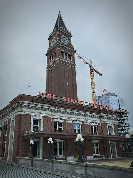
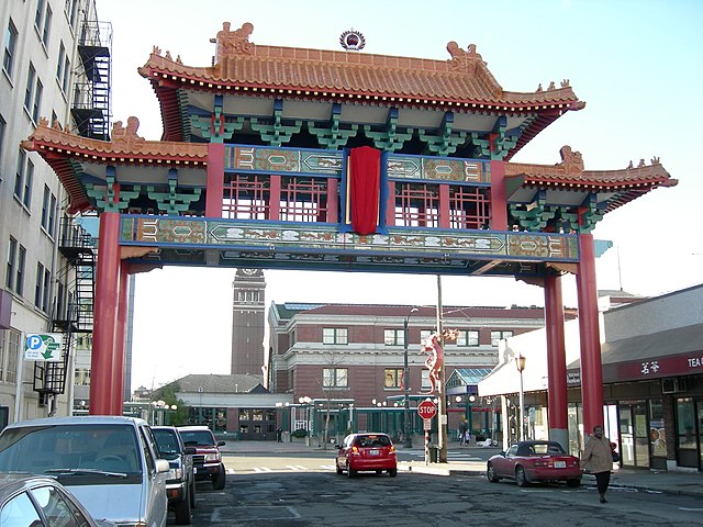
King Street is another of the first streets platted in Seattle by David Swinson “Doc” Maynard in May 1853. It was named after William Rufus DeVane King, a slaveholding Unionist Democratic politician who founded and named Selma, Alabama; was a senator from Alabama from 1819 to 1844 and from 1848 to 1852 (he was ambassador to France in the interim); and was vice president under Franklin Pierce for 45 days in 1853 (he died two days after he returned to the U.S. from Cuba, where he had been convalescing from tuberculosis; King Street was named in his honor 35 days after that).
S King Street begins on the Elliott Bay waterfront at Alaskan Way S and runs ¼ of a mile to King Street Station just past 2nd Avenue S. It resumes at at 5th Avenue S, where it is spanned by the Historic Chinatown Gate, then makes it a full mile to 20th Avenue S, passing through Chinatown and Little Saigon along the way. East of there it exists in various segments, none of which is longer than ⅓ of a mile, and it finally ends at Lakeside Avenue S, where it is one of the String of Pearlsshoreline street ends.
Born and raised in Seattle, Benjamin Donguk Lukoff had his interest in local history kindled at the age of six, when his father bought him settler granddaughter Sophie Frye Bass’s Pig-Tail Days in Old Seattle at the gift shop of the Museum of History and Industry. He studied English, Russian, and linguistics at the University of Washington, and went on to earn his master’s in English linguistics from University College London. His book of rephotography, Seattle Then and Now, was published in 2010. An updated version came out in 2015.
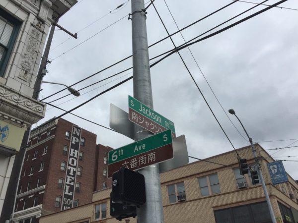
S Jackson Street begins today at Alaskan Way S on the Elliott Bay waterfront and has an uninterrupted 2-mile run as an arterial to 31st Avenue S in Leschi. On the other side of Frink Park, it makes its way the few remaining blocks to Lake Washington as a minor arterial, then a staircase, then a minor street, and finally a shoreline street end, part of the String of Pearls.
Born and raised in Seattle, Benjamin Donguk Lukoff had his interest in local history kindled at the age of six, when his father bought him settler granddaughter Sophie Frye Bass’s Pig-Tail Days in Old Seattle at the gift shop of the Museum of History and Industry. He studied English, Russian, and linguistics at the University of Washington, and went on to earn his master’s in English linguistics from University College London. His book of rephotography, Seattle Then and Now, was published in 2010. An updated version came out in 2015.
Weller Street was among the first streets platted in Seattle by David Swinson “Doc” Maynard in May 1853. It was named after John B. Weller, Democratic senator from California from 1852 to 1857 (Maynard named four streets in his plat after prominent Democratic politicians). Though he wasn’t a slaveowner like President Andrew Jackson or Vice President William R. King, or a future secessionist like Joseph Lane, who was the Southern Democrats’ nominee for vice president in 1860, he was a pro-slavery “Lecompton Democrat” who planned to have California become independent in case of civil war.
S Weller Street begins today at 5th Avenue S and runs ¼ of a mile through the Chinatown–International District to just east of 8th Avenue S, where it, like S Lane Street, is blocked by Interstate 5. It resumes at 10th Avenue S and runs ¾ of a mile to its end at 20th Place S and Washington Middle School.
Born and raised in Seattle, Benjamin Donguk Lukoff had his interest in local history kindled at the age of six, when his father bought him settler granddaughter Sophie Frye Bass’s Pig-Tail Days in Old Seattle at the gift shop of the Museum of History and Industry. He studied English, Russian, and linguistics at the University of Washington, and went on to earn his master’s in English linguistics from University College London. His book of rephotography, Seattle Then and Now, was published in 2010. An updated version came out in 2015.
* As a card-carrying address nerd, I feel compelled to mention that the driveway for the Nippon Kan Theatre/Kobe Park Building at the dead end of S Washington Street is, technically, the northernmost segment of Maynard Avenue S, at least for its first hundred feet.
David Swinson Maynard, ca 1868, photographer unknown
Maynard — unlike Republican Arthur Armstrong Denny, who platted the tract to the north — was a Democrat, and named a number of streets in his plat after prominent Democratic politicians, including the slaveholders President Andrew Jackson and Vice President William Rufus DeVane King; Oregon Territorial Governor Joseph Lane, who went on to be the pro-slavery Southern Democratic candidate for vice president in 1860; and pro-slavery California Senator John B. Weller. I haven’t seen much online about Maynard’s personal racial views, but he was known to have had good relations (given the era) with the local Native Americans, at least. Junius Rochester writes for HistoryLink:
Perhaps one of Doc Maynard’s most enduring qualities, besides his amiability, was his high regard for the local Indians. Chief Seattle was a particular friend, having stated: “My heart is very good toward Dr. Maynard.” Maynard, who knew tribulations in his own life, understood that besides the tools, medicines, guns, and other wonders that the white men had brought to Puget Sound, they also introduced disease, intolerant religions, and the inhospitable idea of private property.
There can be no avoiding his privileged promotion of white settlers at Native Americans’ expense. “They will fight,” he writes on Nov. 4, 1855. “There is no reason why they (sho)uld not, but we must conquer them.”
One hopes that, if Maynard were alive today, he would choose worthier men (and women) to honor than Jackson, King, Lane, and Weller.
Born and raised in Seattle, Benjamin Donguk Lukoff had his interest in local history kindled at the age of six, when his father bought him settler granddaughter Sophie Frye Bass’s Pig-Tail Days in Old Seattle at the gift shop of the Museum of History and Industry. He studied English, Russian, and linguistics at the University of Washington, and went on to earn his master’s in English linguistics from University College London. His book of rephotography, Seattle Then and Now, was published in 2010. An updated version came out in 2015.
Lane Street was another one of Seattle’s first streets, platted on May 23, 1853 by David Swinson “Doc” Maynard. It was named after Joseph Lane, governor of Oregon Territory (which then included what is now Washington) from March 1849 to June 1850. Ten years later, he was the pro-slavery, pro-secession Southern Democratic nominee for vice president, with John C. Breckenridge at the head of the ticket.
S Lane Street begins today at 6th Avenue S just east of the flagship Uwajimaya grocery store, and runs ⅕ of a mile through the Chinatown–International District to just east of 8th Avenue S, where it is blocked by Interstate 5. East of there, it is a path and stairway from 10th to 13th Avenues S, past which it appears in segments of varying lengths until it ends for good at Lakeside Avenue S.
Born and raised in Seattle, Benjamin Donguk Lukoff had his interest in local history kindled at the age of six, when his father bought him settler granddaughter Sophie Frye Bass’s Pig-Tail Days in Old Seattle at the gift shop of the Museum of History and Industry. He studied English, Russian, and linguistics at the University of Washington, and went on to earn his master’s in English linguistics from University College London. His book of rephotography, Seattle Then and Now, was published in 2010. An updated version came out in 2015.
Washington Street was one of Seattle’s first streets, platted on May 23, 1853 by David Swinson “Doc” Maynard and named after President George Washington. Its initial segment begins at Alaskan Way S on the Elliott Bay waterfront and ends half a mile to the east at Kobe Terrace Park. East of Interstate 5 it exists in a number of segments interrupted by schools and parks and finally ends at S Frink Place and Frink Park.
Born and raised in Seattle, Benjamin Donguk Lukoff had his interest in local history kindled at the age of six, when his father bought him settler granddaughter Sophie Frye Bass’s Pig-Tail Days in Old Seattle at the gift shop of the Museum of History and Industry. He studied English, Russian, and linguistics at the University of Washington, and went on to earn his master’s in English linguistics from University College London. His book of rephotography, Seattle Then and Now, was published in 2010. An updated version came out in 2015.
Plat of an Addition to the Town of Seattle as Laid Out by A.A. Denny, November 16, 1861
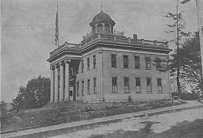
Territorial University of Washington on opening day, November 4, 1861
Even though the University of Washington moved to its current location on Portage and Union Bays in 1895, the name was not changed. Nor did the university relinquish the land, though not for lack of trying. This turns out to have been fortunate. The UW owns the Metropolitan Tract to this day, and it earned $25 million in rent on the property during fiscal year 2020 alone.
The street, which originally ran from Front Street (now 1st Avenue) to the university campus, just northeast of 3rd Avenue, today begins at Alaskan Way on the Elliott Bay waterfront, and makes it just one block, to Western Avenue, before it becomes the Harbor Steps. From 1st Avenue, it’s about a third of a mile to 7th Avenue, where University Street is blocked by Interstate 5. It resumes at 9th Avenue and goes for another third of a mile to Boylston Avenue.
Portion of King County quarter section maps covering Metropolitan Tract
Incidentally, you’ll notice in the map above that 4th and 5th Avenues between Seneca and Union Streets, as well as University Street between 4th and 5th Avenues, plus half a block on either end, are marked private way subject to public use — long term grant of use for street purposes. This fact — that the University of Washington still owns all the land within the Metropolitan Tract and never formally dedicated those streets to the public — was something I never knew until I started taking close looks at King County’s quarter section maps as part of my local history research. It might seem an academic distinction, but as The Seattle Timesreported in 2015, there are very real financial consequences.
In 2008… the UW wanted the city to interpret the tract as one undivided lot, streets and all. That novel argument would benefit the UW in calculating the development footprint, or base.… The bigger the base, the logic went, the more square footage a developer could build before triggering affordable-housing fees under the city’s formula.… The university held a heavy hammer in negotiations. Because the UW owned development rights for the land under Fifth Avenue and University Street, it could make the city compensate it, one way or another, for using those streets.
Born and raised in Seattle, Benjamin Donguk Lukoff had his interest in local history kindled at the age of six, when his father bought him settler granddaughter Sophie Frye Bass’s Pig-Tail Days in Old Seattle at the gift shop of the Museum of History and Industry. He studied English, Russian, and linguistics at the University of Washington, and went on to earn his master’s in English linguistics from University College London. His book of rephotography, Seattle Then and Now, was published in 2010. An updated version came out in 2015.
Madison Street — another of Seattle’s “first streets” — was named for James Madison, president of the United States from 1809 to 1817. It is the only street in town that stretches, uninterrupted, from the salt water of Elliott Bay and Puget Sound to the fresh water of Lake Washington.
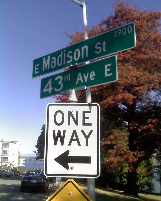
Originating as the McGilvra Road in 1861, Madison Street begins on the Elliott Bay waterfront at Alaskan Way and ends 3¾ miles northeast of there at a small fishing pier, just east of 43rd Avenue E and north of Madison Park Beach. Apart from a slight bend to the northeast at 22nd Avenue, it is as straight as an arrow from beginning to end.
Born and raised in Seattle, Benjamin Donguk Lukoff had his interest in local history kindled at the age of six, when his father bought him settler granddaughter Sophie Frye Bass’s Pig-Tail Days in Old Seattle at the gift shop of the Museum of History and Industry. He studied English, Russian, and linguistics at the University of Washington, and went on to earn his master’s in English linguistics from University College London. His book of rephotography, Seattle Then and Now, was published in 2010. An updated version came out in 2015.
Spring Street was another of Seattle’s “first streets.” Sophie Frye Bass writes in Pig-Tail Days in Old Seattle:
Where springs of clear water bubbled from the earth and the beach was sandy and free from rocks, there the Indians camped. Such a choice spot was Tzee-tzee-lal-litch [dzidzəlalič], which Arthur Denny called Spring Street.
Spring Street begins at Alaskan Way and runs nearly a mile, to Harvard Avenue, before it is interrupted. A few more segments run through the Central District and Madrona. The last is from 38th Avenue to Grand Avenue, at which point it continues to Lake Washington Boulevard as a footpath and stairway.
Born and raised in Seattle, Benjamin Donguk Lukoff had his interest in local history kindled at the age of six, when his father bought him settler granddaughter Sophie Frye Bass’s Pig-Tail Days in Old Seattle at the gift shop of the Museum of History and Industry. He studied English, Russian, and linguistics at the University of Washington, and went on to earn his master’s in English linguistics from University College London. His book of rephotography, Seattle Then and Now, was published in 2010. An updated version came out in 2015.
Cherry Street was among the first streets platted in Seattle on May 23, 1853. Sophie Frye Bass, author of Pig-Tail Days in Old Seattle, writes:
I choose to think that Cherry Street is named for the little town of Cherry Grove, Illinois — Mother’s birthplace — where the Dennys started on their long journey over the Oregon Trail.
In 2006, Hunter Brown wrote a People’s History essay for HistoryLink, “Finding Cherry Grove,” detailing his efforts to locate Cherry Grove, whose name was later changed to Cedar Township. The nearest town today is called Abingdon.
Bass began her Pig-Tail Days piece on Cherry Street by calling it “another up-and-up street… with no interferences. It begins at First Avenue, goes east and ends at Thirty-seventh avenue.” This is no longer quite the case because of a very small gap at the south end of the Seattle University campus. Today, Cherry begins at 1st Avenue and ends a block east of Broadway. It starts up again a couple hundred feet to the east as a continuation of the James Street/E James Way arterial, and then does go on to 37th Avenue in Madrona. All told it is 2⅓ miles long.
Born and raised in Seattle, Benjamin Donguk Lukoff had his interest in local history kindled at the age of six, when his father bought him settler granddaughter Sophie Frye Bass’s Pig-Tail Days in Old Seattle at the gift shop of the Museum of History and Industry. He studied English, Russian, and linguistics at the University of Washington, and went on to earn his master’s in English linguistics from University College London. His book of rephotography, Seattle Then and Now, was published in 2010. An updated version came out in 2015.
Marion Street runs ⅖ of a mile from Alaskan Way to 6th Avenue, where it is interrupted by Interstate 5. It picks up again at 7th Avenue and runs about the same distance to Broadway, where the Seattle University campus begins. East of there it runs in sections of varying lengths until it ends for good at 38th Avenue and Madrona Park.
Born and raised in Seattle, Benjamin Donguk Lukoff had his interest in local history kindled at the age of six, when his father bought him settler granddaughter Sophie Frye Bass’s Pig-Tail Days in Old Seattle at the gift shop of the Museum of History and Industry. He studied English, Russian, and linguistics at the University of Washington, and went on to earn his master’s in English linguistics from University College London. His book of rephotography, Seattle Then and Now, was published in 2010. An updated version came out in 2015.
James Street, one of the first streets platted in Seattle on May 23, 1853, was named by Arthur Armstrong Denny after his younger brother, James Marion Denny (1824–1854). Histories of Seattle report that James was too sick to leave Oregon and come to Puget Sound with the Denny Party and, indeed, he died in the town of Sublimity, Oregon, just a year after the street was named for him. Nothing I have found reports an actual cause of death. Marion Street is also named after this brother.
James Street runs ¾ of a mile from Yesler Way just east of 1st Avenue to an alley just east of Broadway. It appears east of there in a few short stretches and finally as a stairway from 38th Avenue to Lake Washington Boulevard at Madrona Park.
Born and raised in Seattle, Benjamin Donguk Lukoff had his interest in local history kindled at the age of six, when his father bought him settler granddaughter Sophie Frye Bass’s Pig-Tail Days in Old Seattle at the gift shop of the Museum of History and Industry. He studied English, Russian, and linguistics at the University of Washington, and went on to earn his master’s in English linguistics from University College London. His book of rephotography, Seattle Then and Now, was published in 2010. An updated version came out in 2015.
Plat of the Town of Seattle, May 23, 1853, by Carson Dobbins Boren and Arthur Armstrong Denny
Plat of the Town of Seattle, King County, Washington Territory, May 23, 1853, by David Swinson Maynard
Mill Street, which divided the two plats, was renamed Yesler Avenue in 1888, and Yesler Way — its current name — seven years later. Front Street became 1st Avenue and Commercial Street became 1st Avenue S as part of that same “Great Renaming” ordinance of 1895. Streets that were named in these first plats that have kept their names till today include:
Boren and Denny
James Street — after James Marion Denny, younger brother of A.A. Denny
Cherry Street — after Cherry Grove, Illinois, where the Denny Party’s journey to Seattle began
Born and raised in Seattle, Benjamin Donguk Lukoff had his interest in local history kindled at the age of six, when his father bought him settler granddaughter Sophie Frye Bass’s Pig-Tail Days in Old Seattle at the gift shop of the Museum of History and Industry. He studied English, Russian, and linguistics at the University of Washington, and went on to earn his master’s in English linguistics from University College London. His book of rephotography, Seattle Then and Now, was published in 2010. An updated version came out in 2015.
This street runs just over ¼ of a mile from 37th Avenue E in the north, by Lakeview Park, to E Howell Street and 39th Avenue in the south. It was named for George and Otilde Dorffel, who might otherwise be best known for giving Ravenna its name.
In the original 1901 plat of Denny-Blaine-Lake Park, the Dorffel Drive name was given to what is now Madrona Place E, and what is now Dorffel Drive was then 37th Avenue. The change, which took place in 1906, would seem to have been done to eliminate the oddity of 39th Avenue becoming 37th Avenue as it crossed E Howell Street.
Born and raised in Seattle, Benjamin Donguk Lukoff had his interest in local history kindled at the age of six, when his father bought him settler granddaughter Sophie Frye Bass’s Pig-Tail Days in Old Seattle at the gift shop of the Museum of History and Industry. He studied English, Russian, and linguistics at the University of Washington, and went on to earn his master’s in English linguistics from University College London. His book of rephotography, Seattle Then and Now, was published in 2010. An updated version came out in 2015.
This street runs around 650 feet from 34th Avenue E, just north of E Denny Way, to 37th Avenue East. It was established in 1903 as part of Waddell’s Madrona Park Addition to the City of Seattle by, among others, Albert and Florence M. Waddell.
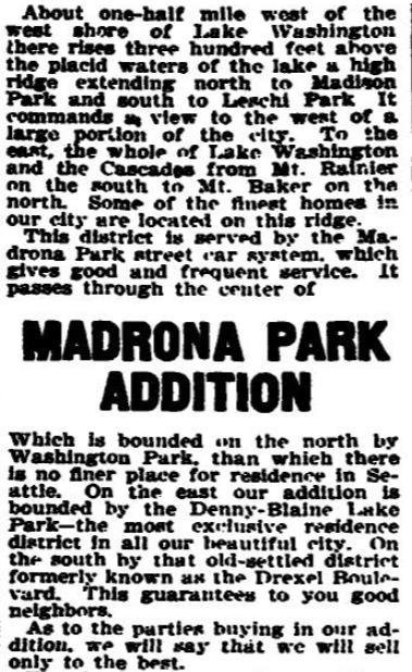
Advertisement for Madrona Park Addition, The Seattle Times, April 7, 1903
Born and raised in Seattle, Benjamin Donguk Lukoff had his interest in local history kindled at the age of six, when his father bought him settler granddaughter Sophie Frye Bass’s Pig-Tail Days in Old Seattle at the gift shop of the Museum of History and Industry. He studied English, Russian, and linguistics at the University of Washington, and went on to earn his master’s in English linguistics from University College London. His book of rephotography, Seattle Then and Now, was published in 2010. An updated version came out in 2015.


.jpg)