Born and raised in Seattle, Benjamin Donguk Lukoff had his interest in local history kindled at the age of six, when his father bought him settler granddaughter Sophie Frye Bass’s Pig-Tail Days in Old Seattle at the gift shop of the Museum of History and Industry. He studied English, Russian, and linguistics at the University of Washington, and went on to earn his master’s in English linguistics from University College London. His book of rephotography, Seattle Then and Now, was published in 2010. An updated version came out in 2015.
Aerial of Mount Baker Park, March 18, 1971. Lake Park Drive S is just east (toward the bottom of the photograph) of the green swath at center. Courtesy of the Seattle Municipal Archives, Identifier 78115
Lake Park Drive S begins at the intersection of S McClellan Street, S Mount Baker Boulevard, Mount Baker Drive S, and Mount Rainier Drive S, and goes ⅓ of a mile north to Lake Washington Boulevard S.
Born and raised in Seattle, Benjamin Donguk Lukoff had his interest in local history kindled at the age of six, when his father bought him settler granddaughter Sophie Frye Bass’s Pig-Tail Days in Old Seattle at the gift shop of the Museum of History and Industry. He studied English, Russian, and linguistics at the University of Washington, and went on to earn his master’s in English linguistics from University College London. His book of rephotography, Seattle Then and Now, was published in 2010. An updated version came out in 2015.
This street, created in 1926 as part of the plat of The Uplands (S Upland Road), was so named because it runs along the Lake Washington shoreline just south of Seward Park.
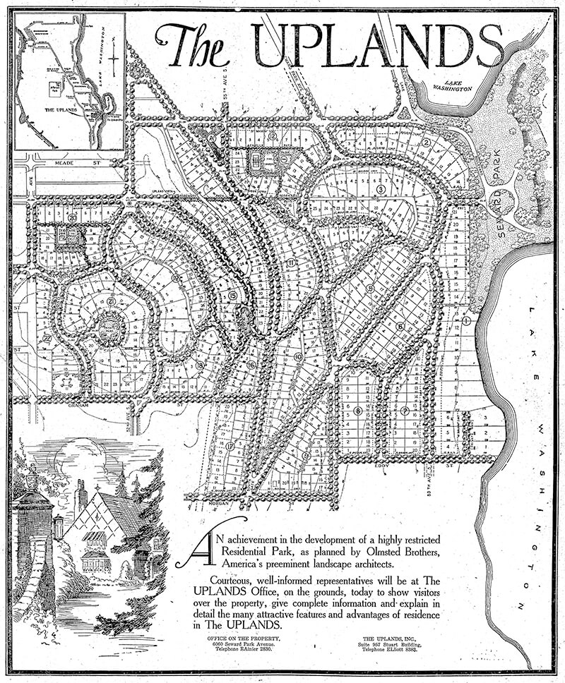
Full-page ad for The Uplands in The Seattle Times, September 27, 1925. Lake Shore Drive is at the lower right-hand corner of the plat.
Lake Shore Drive S begins at Seward Park Avenue S and S Hawthorn Road and goes ¼ mile south to S Eddy Street.
Born and raised in Seattle, Benjamin Donguk Lukoff had his interest in local history kindled at the age of six, when his father bought him settler granddaughter Sophie Frye Bass’s Pig-Tail Days in Old Seattle at the gift shop of the Museum of History and Industry. He studied English, Russian, and linguistics at the University of Washington, and went on to earn his master’s in English linguistics from University College London. His book of rephotography, Seattle Then and Now, was published in 2010. An updated version came out in 2015.
Born Giovanni Domenicio Corgiat in Italy, John was a real estate investor who, according to his Seattle Times obituary, was also notable for “establish[ing] the Louvre Restaurant, the first French-Italian eating place in Seattle, in 1888.” (It was destroyed the next year in the Great Seattle Fire.) He was also apparently involved in a number of legal cases relating to the explusion of restaurateur John Cicoria from the Joseph Mazzini Society in 1907: not only the lawsuit demanding Cicoria’s reinstatement in the Italian-American fraternal organization, but one in which the society succeeded in making him pay its legal fees, and three libel suits — one which Cicoria won against Corgiat, and two which Corgiat filed against The Seattle Times and the Message-Vero-Italo-Americano with Cicoria as co-defendant in each. The suit against the Times was dismissed at Corgiat’s request; I haven’t been able to find any more information about the other.
John Corgiat, from his obituary in the Seattle Times, December 10, 1936
Originally Corgiat Street, S Corgiat Drive begins at the railroad tracks just east of Airport Way S and goes 300 feet northeast to just past Ursula Place S, at which point it turns northwest and becomes S Corgiat Drive (not in the original plat). From there, it goes ⅖ of a mile to S Albro Place, just west of Interstate 5.
Born and raised in Seattle, Benjamin Donguk Lukoff had his interest in local history kindled at the age of six, when his father bought him settler granddaughter Sophie Frye Bass’s Pig-Tail Days in Old Seattle at the gift shop of the Museum of History and Industry. He studied English, Russian, and linguistics at the University of Washington, and went on to earn his master’s in English linguistics from University College London. His book of rephotography, Seattle Then and Now, was published in 2010. An updated version came out in 2015.
This street, created in 1888 as part of the First Plat of West Seattle by the West Seattle Land and Improvement Company, was originally named Grand Avenue. It was renamed, along with many other West Seattle streets, in 1907, when West Seattle was annexed by Seattle. The name was a reference to the WSL&IC ferry terminal at what is today Harbor Avenue SW at California Way SW. The West Seattle Water Taxi has been operating from the same location since 1997.
Today, Ferry Avenue SW begins at California Way SW and goes about ³⁄₇ of a mile southwest to just past California Avenue SW, at California Place park (built on the site of a former streetcar terminal; before that, a cable car ran up the Ferry Avenue right-of-way from Elliott Bay to this location). It resumes on the other side of the park at SW Hill Street and goes a further 600 feet southwest to SW Walker Street.
Born and raised in Seattle, Benjamin Donguk Lukoff had his interest in local history kindled at the age of six, when his father bought him settler granddaughter Sophie Frye Bass’s Pig-Tail Days in Old Seattle at the gift shop of the Museum of History and Industry. He studied English, Russian, and linguistics at the University of Washington, and went on to earn his master’s in English linguistics from University College London. His book of rephotography, Seattle Then and Now, was published in 2010. An updated version came out in 2015.
This street, established in 1913 as Sturtevant Place, was named for real estate investor, banker, and antique store owner Cullen Kittredge Sturtevant (1865–1946), who developed a number of tracts in what is now Rainier Beach. Unlike many developers, he didn’t name this street after himself; it was added by the city nearly a decade after he filed Sturtevant’s Plat of Rainier Beach Acre Tracts.
Today, Sturtevant Avenue S begins at Rainier Avenue S between 51st Avenue S and 52nd Avenue S and goes ⅕ of a mile southeast to 52nd Avenue S and S Roxbury Street. Sturtevant Ravine, through which Mapes Creek runs on its way from Kubota Garden to Beer Sheva Park and Lake Washington, lies to its west.
Ad for Sturtevant’s Rainier Beach Lake Front Tracts, The Seattle Times, April 8, 1906
Born and raised in Seattle, Benjamin Donguk Lukoff had his interest in local history kindled at the age of six, when his father bought him settler granddaughter Sophie Frye Bass’s Pig-Tail Days in Old Seattle at the gift shop of the Museum of History and Industry. He studied English, Russian, and linguistics at the University of Washington, and went on to earn his master’s in English linguistics from University College London. His book of rephotography, Seattle Then and Now, was published in 2010. An updated version came out in 2015.
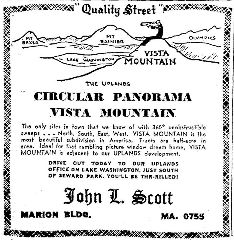
This street, like S Upland Road, was created in 1926 as part of the plat of The Uplands, so named for its location on a hill overlooking Seward Park. This portion of the neighborhood, however, wasn’t developed until the early 1950s, after having been replatted in 1949 as Vista Mountain.
Ad for the Vista Mountain subdivision, The Seattle Times, February 12, 1950
Upland Terrace S begins at 52nd Avenue S just north of S Graham Street and goes around 1,500 feet north to 51st Place S at S Juneau Street.
Born and raised in Seattle, Benjamin Donguk Lukoff had his interest in local history kindled at the age of six, when his father bought him settler granddaughter Sophie Frye Bass’s Pig-Tail Days in Old Seattle at the gift shop of the Museum of History and Industry. He studied English, Russian, and linguistics at the University of Washington, and went on to earn his master’s in English linguistics from University College London. His book of rephotography, Seattle Then and Now, was published in 2010. An updated version came out in 2015.
This street was created in 1926 as part of the plat of The Uplands, so named for its location on a hill overlooking Seward Park. Designed by the Olmsted Brothers firm, it was advertised as “a highly restricted residential park” (see below, The Seattle Times, September 27, 1925). A separate advertisement that ran on September 30 of the same year spoke of the “protective restrictions by which the home sites are safeguarded,” and another one on October 9 described The Uplands as “a residential district so carefully planned and highly restricted the home owner may look into the future with full knowledge and assurance that his property will, for all time, be safeguarded and protected.”
Full-page ad for The Uplands in The Seattle Times, September 27, 1925
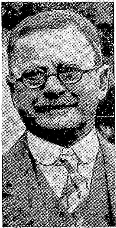
Neither the Friends of Seattle’s Olmsted Parks nor the Seattle Civil Rights and Labor History Project have found any evidence of racial restrictive covenants for The Uplands, though it’s marked in the latter’s database as “restrictions were advertised in newspapers and enforced by realtors, but deed records have not yet been found in partial search.” As the Friends of Seattle’s Olmsted Parks’ history of Seward Park notes,
…In 1960 a group of white neighbors, led by realtor John L. Scott, tried to prevent an African American physician and his family from moving in. The Civic Unity Committee (CUC) documented what happened. Dr. J.R. Henry ultimately moved his family in without disturbance that December, though Scott delivered a parting message saying Henry was “no gentleman” for refusing Scott’s offer (to buy him out).
You can learn more about the Henrys’ story in this article by KUOW’s Isolde Raftery.
Today, S Upload Road begins at Wilson Avenue S and goes 1,000 feet northeast to S Hawthorn Road.
Born and raised in Seattle, Benjamin Donguk Lukoff had his interest in local history kindled at the age of six, when his father bought him settler granddaughter Sophie Frye Bass’s Pig-Tail Days in Old Seattle at the gift shop of the Museum of History and Industry. He studied English, Russian, and linguistics at the University of Washington, and went on to earn his master’s in English linguistics from University College London. His book of rephotography, Seattle Then and Now, was published in 2010. An updated version came out in 2015.
This street was created in 1900 as part of the plat of the Orchard Hill Addition, filed by Martin Dean, Sarah J. Dean, Elizabeth H. Lewis, William H. Lewis, the W.C. Hill Brick Company, and the First National Bank of Seattle. According to Don Sherwood, it was named for John J. Sturgus, “realtor and agent of [the] W.C. Hill Estate” (Hill had died in 1890).
I do find mentions of a John J. Sturgus, associated with the Hill Company or the Hill Estate, in a number of Polk directories. However, it appears a Dr. John J. Sturgus (1859–1907) was also the brother of Hill’s wife, born Alice Bradley Sturgus (1847–1904).
Article in the (Washington, D.C.) Evening Star, September 9, 1890, on the death of W.C. Hill, mentioning Mrs. Hill’s mother (“Mrs. Sturgus”) and brother (Dr. John J. Sturgus).
Given the unlikelihood of two completely different John J. Sturguses being associated with the Hills, I’m going to assume that the physician and real estate man were one and the same, and that the street was given its name either because Dr. Sturgus was Hill’s brother-in-law or because Sturgus was his wife’s maiden name (or both). If the latter, that puts it in the same category as Perkins Lane W, Thorndyke Avenue W, and Keen Way N.
Today, Sturgus Avenue S begins at S Charles Street, just east of the Jose Rizal Bridge, and goes ½ a mile southeast, then south, to S State Street. The right-of-way continues a block further, to the S Grand Street right-of-way, but houses with addresses on that block are accessed by a private alley north of 16th Avenue S.
Born and raised in Seattle, Benjamin Donguk Lukoff had his interest in local history kindled at the age of six, when his father bought him settler granddaughter Sophie Frye Bass’s Pig-Tail Days in Old Seattle at the gift shop of the Museum of History and Industry. He studied English, Russian, and linguistics at the University of Washington, and went on to earn his master’s in English linguistics from University College London. His book of rephotography, Seattle Then and Now, was published in 2010. An updated version came out in 2015.
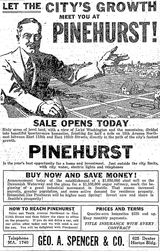
This street was established in 1926 as part of the plat of Pinehurst. Originally beginning at 15th Avenue NE and NE 117th Street and going northeast to 17th Avenue NE between NE 123rd Street and NE 125th Street, it was subsequently extended to connect the 15th Avenue NE and Roosevelt Way NE arterials.
Today, Pinehurst Way NE begins at Roosevelt Way NE and NE 113th Street, and goes ⅔ of a mile northeast to 17th Avenue NE and NE 124th Street.
Ad for Pinehurst, The Seattle Times, October 3, 1926
Born and raised in Seattle, Benjamin Donguk Lukoff had his interest in local history kindled at the age of six, when his father bought him settler granddaughter Sophie Frye Bass’s Pig-Tail Days in Old Seattle at the gift shop of the Museum of History and Industry. He studied English, Russian, and linguistics at the University of Washington, and went on to earn his master’s in English linguistics from University College London. His book of rephotography, Seattle Then and Now, was published in 2010. An updated version came out in 2015.
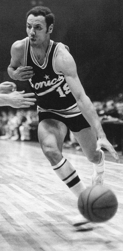
I’m not sure how I missed the news, but in December 2021 the block of Thomas Street between 1st Avenue N and 2nd Avenue N/Seattle Storm Way, just south of Climate Pledge Arena, was officially renamed Lenny Wilkens Way, after the Seattle basketball legend.
Leonard Randolph Wilkens (born 1937), who grew up in Brooklyn, New York, played basketball for the Seattle SuperSonics from 1968–1972, also serving as head coach from 1969–1972. He returned to coach the Sonics in 1977 and stayed until 1986, when he went to the Cleveland Cavaliers. He led the Sonics to two consecutive NBA championship games, in 1978 and 1979, the latter of which the Sonics won, giving Seattle its first national title since the Metropolitans won the Stanley Cup in 1917, and its last until 2004, when the Storm won the WNBA Championship. Wilkens finished his career as head coach of the New York Knicks in 2005. Through the Lenny Wilkens Foundation, which recently wound up operations, he also raised millions of dollars for Seattle Children’s Odessa Brown Children’s Clinic.
As far as I know, and please correct me if I’m wrong, this makes Lenny Wilkens only the second Black person to have a street named after him in Seattle, the first being Martin Luther King Jr.
At left, Lenny Wilkens in 1968; public domain photograph by Malcolm Emmons of The Sporting News. At right, Wilkens in 2013; public domain photograph by Technical Sergeant Samuel Morse, U.S. Air Force.
Born and raised in Seattle, Benjamin Donguk Lukoff had his interest in local history kindled at the age of six, when his father bought him settler granddaughter Sophie Frye Bass’s Pig-Tail Days in Old Seattle at the gift shop of the Museum of History and Industry. He studied English, Russian, and linguistics at the University of Washington, and went on to earn his master’s in English linguistics from University College London. His book of rephotography, Seattle Then and Now, was published in 2010. An updated version came out in 2015.
This street was created in 1964 as part of the plat of Shoreline Park Estates. The subdivision was presumably named for Carkeek Park, which surrounds it on three sides and features a long Puget Sound shoreline.
Advertisement for Shoreline Park Estates, The Seattle Times, September 20, 1964. The address and phone number of Royal Homes Realty — 14802 Westminster Way N., Seattle 33, EMerson 4-5180 — would today be Shoreline, WA 98133, 206-364-5180, because of the incorporation of Shoreline in 1995; the mandatory use of ZIP Codes by bulk mailers, which began in 1967; the transition to all-number calling, which was completed in Greater Seattle in 1972; and the mandatory use of 10-digit dialing, which began in Greater Seattle in 2017.
Shoreline Park Drive NW runs about 275 feet between NW 118th Street and NW 117th Street. The developers dedicated a walkway west of NW 117th Street to the public; this connects to the Grand Fir Trail, one of Carkeek Park’s many trails.
Born and raised in Seattle, Benjamin Donguk Lukoff had his interest in local history kindled at the age of six, when his father bought him settler granddaughter Sophie Frye Bass’s Pig-Tail Days in Old Seattle at the gift shop of the Museum of History and Industry. He studied English, Russian, and linguistics at the University of Washington, and went on to earn his master’s in English linguistics from University College London. His book of rephotography, Seattle Then and Now, was published in 2010. An updated version came out in 2015.
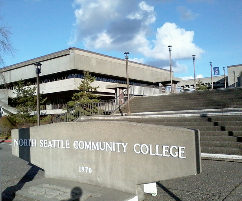
This street was named in 1971 as part of a project to connect Meridian Avenue N at N 103rd Street to Burke Avenue N at N 100th Street; the newly constructed street took the name, as did Burke Avenue south to N 92nd Street. For its entire ½-mile length, College Way N is the western boundary of the campus of North Seattle College, known at its 1970 founding as North Seattle Community College.
Born and raised in Seattle, Benjamin Donguk Lukoff had his interest in local history kindled at the age of six, when his father bought him settler granddaughter Sophie Frye Bass’s Pig-Tail Days in Old Seattle at the gift shop of the Museum of History and Industry. He studied English, Russian, and linguistics at the University of Washington, and went on to earn his master’s in English linguistics from University College London. His book of rephotography, Seattle Then and Now, was published in 2010. An updated version came out in 2015.
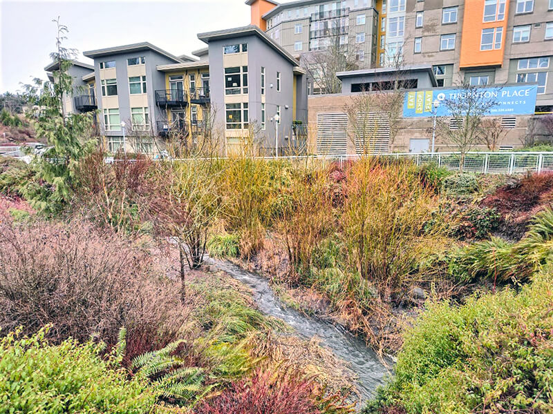
Thornton Creek runs 18 miles from Shoreline to Seattle, where it empties into Lake Washington at Matthews Beach Park. Its watershed, which drains 11.6 square miles, is the largest in Seattle. Yet until recently, no street bore its name — and the one that now does is a short private road.
NE Thornton Place, which runs not quite 500 feet between 3rd Avenue NE and NE 103rd Street, cuts through the Thornton Place development, built on the site of a former Northgate Mall parking lot under which the South Fork of Thornton Creek ran in a culvert. A portion of the creek was daylighted as part of the project. (Incidentally, I had the pleasure of seeing the IMAX version of The Beatles: Get Back – The Rooftop Concert at the Regal Thornton Place on January 30 of this year, the 53rd anniversary of the historic event. I am an even bigger fan of the Beatles than I am of odonymy!) You can read more about the Thornton Creek Water Quality Channel at Wedgwood in Seattle History.
I originally wrote here that “The creek is named for John Q. Thornton (1825–1904), who… never actually lived in the Seattle area, but in 1885 bought land near what are today Meridian Park and Twin Ponds Park, at or near the headwaters of Meridian Creek, a tributary of the North Fork of Thornton Creek….” However, in the summer of 2022, the person whose article on Thornton I cited told me that they no longer believed this to be the case, and had edited their article accordingly. The creek’s namesake, therefore, remains a mystery.
Born and raised in Seattle, Benjamin Donguk Lukoff had his interest in local history kindled at the age of six, when his father bought him settler granddaughter Sophie Frye Bass’s Pig-Tail Days in Old Seattle at the gift shop of the Museum of History and Industry. He studied English, Russian, and linguistics at the University of Washington, and went on to earn his master’s in English linguistics from University College London. His book of rephotography, Seattle Then and Now, was published in 2010. An updated version came out in 2015.
This street was created in 1926 as part of Belvoir, an Addition to the City of Seattle, filed by the executor of the estate of William Harvey “Uncle Joe” Surber (1834–1923) (Surber Drive NE). Surber had homesteaded what is now Laurelhurst in 1861, and an article in the September 19, 1926, issue of The Seattle Times noted that Belvoir was “one of the last, if not the last tract of land that [had] been held intact by its owners since pioneer days.”
Advertisement for Belvoir, The Seattle Times, September 17, 1926
NE Belvoir Place begins at Surber Drive NE and goes around 850 feet northeast to 41st Avenue NE. (There is also a park named Belvoir Place; located 1,000 feet to the southeast, it is a narrow parcel that stretches from 42nd Avenue NE to Union Bay.)
Born and raised in Seattle, Benjamin Donguk Lukoff had his interest in local history kindled at the age of six, when his father bought him settler granddaughter Sophie Frye Bass’s Pig-Tail Days in Old Seattle at the gift shop of the Museum of History and Industry. He studied English, Russian, and linguistics at the University of Washington, and went on to earn his master’s in English linguistics from University College London. His book of rephotography, Seattle Then and Now, was published in 2010. An updated version came out in 2015.
William Mortimer Lucas… was born in Illinois. Between 1908 and 1913 he was a speculative builder of houses in Seattle’s north end, houses that were financed by the sale of stock.… His office was located in the White Building in downtown Seattle. By 1912, the company was also selling plans for bungalows.
N Lucas Place begins at Stone Way N between N 40th Street and N 41st Street and goes about 375 feet east to Interlake Avenue N.
Born and raised in Seattle, Benjamin Donguk Lukoff had his interest in local history kindled at the age of six, when his father bought him settler granddaughter Sophie Frye Bass’s Pig-Tail Days in Old Seattle at the gift shop of the Museum of History and Industry. He studied English, Russian, and linguistics at the University of Washington, and went on to earn his master’s in English linguistics from University College London. His book of rephotography, Seattle Then and Now, was published in 2010. An updated version came out in 2015.
This street was created in 1928 as part of the Golfcrest addition, named for the adjacent Jackson Park golf course that had opened earlier that year. Other named streets in the subdivision included Golfcrest Drive, Fairway Place, Bogey Place, and Tee Place. None of these streets exist any longer — Lakeside School moved to the neighborhood in 1930 and had the north portion of the plat vacated for its new campus, and the construction of Interstate 5 took out Golfcrest Drive in the mid 1960s.
This northeast-looking aerial photo shows, from left to right (west to east), the Lakeside School campus (north portion of Golfcrest addition); Interstate 5; 5th Avenue NE; and the Jackson Park golf course. The overpass crossing I-5 is NE 145th Street (Washington State Route 523), which forms the boundary between Seattle to the south and Shoreline to the north. The Shoreline South/148th light rail station can be seen under construction just north of the overpass. Par Place itself is out of frame, to the south. Photograph by Flickr user Atomic Taco, September 26, 2021, licensed under Creative Commons Attribution-ShareAlike 2.0 Generic.
Par Place NE begins at NE 139th Street and goes ⅕ of a mile north to NE 140th Street, at the south end of the Lakeside campus.
Born and raised in Seattle, Benjamin Donguk Lukoff had his interest in local history kindled at the age of six, when his father bought him settler granddaughter Sophie Frye Bass’s Pig-Tail Days in Old Seattle at the gift shop of the Museum of History and Industry. He studied English, Russian, and linguistics at the University of Washington, and went on to earn his master’s in English linguistics from University College London. His book of rephotography, Seattle Then and Now, was published in 2010. An updated version came out in 2015.
This North Queen Anne street originates in the 1907 Mayfair Addition to the City of Seattle, filed by the Mayfair Land Company. Don Sherwood notes that “Mayfair is a fashionable district in London, east of Hyde Park,” which was named after the annual May Fair (1686–1764).
Advertisement for the Mayfair Addition in The Seattle Times, March 8, 1907
Mayfair Avenue N begins at Florentia Street between 2nd Avenue N and 3rd Avenue N and goes just over ¼ of a mile south to just past Mayfair Park, where it becomes a private road that goes around 600 feet east to Nob Hill Avenue N. The private section runs through land once owned by the Lorentz family (Lorentz Place N) — in fact, a few members still own houses there.
Born and raised in Seattle, Benjamin Donguk Lukoff had his interest in local history kindled at the age of six, when his father bought him settler granddaughter Sophie Frye Bass’s Pig-Tail Days in Old Seattle at the gift shop of the Museum of History and Industry. He studied English, Russian, and linguistics at the University of Washington, and went on to earn his master’s in English linguistics from University College London. His book of rephotography, Seattle Then and Now, was published in 2010. An updated version came out in 2015.
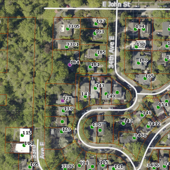
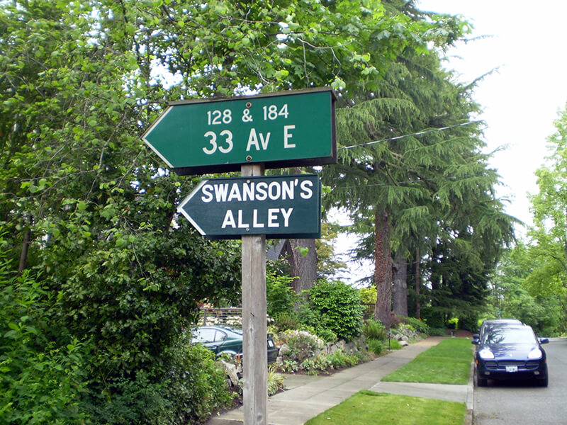
Officially, this alley off 34th Avenue E between E John Street and 35th Avenue E is unnamed. That proved inconvenient for Jack Sussman and Cathy Nunneley, who live at 184 and 128 33rd Avenue E, respectively. Yes, 33rd Avenue E, even though their house is accessed from 34th.
I don’t know how it works in other cities, but in Seattle, you can have an address on a nonexistent — or, more accurately, unimproved — street. This is the case with W Semple Street — the three residences with a Semple address are only accessible from 45th Avenue W. And this is the case here. Unlike Semple, 33rd Avenue E is improved… but not for the entire length of its right-of-way. From about 450 feet south of E Harrison Street to about 175 feet north of E Denny Way, 33rd Avenue E is unimproved and makes up part of the Harrison Ridge Greenbelt.
Swanson’s Alley and surrounding streets as shown on King County Parcel Viewer. Address points appear in green, except for 128 and 184 33rd Avenue E, which appear in purple.
We have a problem because our address is one that people cannot find. Get a new mailperson and we won’t see any mail for a week!… How many Roto-Rooter men, phone line fixers, and Craigslist contacts have been lost trying to find us? GPS and MapQuest systems are useless for locating my house. How many times have I run out to the street vainly searching for the delivery truck going round and round the neighborhood?
He goes on to explain that “a fine article lamenting [the] neglect of city alleys” written by Knute Berger inspired him to put up a sign reading “Swanson’s Alley” underneath the city’s official sign directing people to his and Nunneley’s houses. He chose the name to honor “Swanson, a Swedish carpenter, [who] lived here in the 1930s,” and happily reports that giving the alley a name, albeit unofficial, did indeed help people find his residence.
In the next issue of The Valley View, Sussman reports that he was able to locate a grandson of this Swanson, to give him the news and get further details on the alley’s namesake:
The grandfather who founded the family here was Elof Svenson [1881–1958]; the name later became Swanson in America. Elof was a teenage laborer, a Swedish immigrant who spoke little English. I had one detail wrong: he was not a carpenter but a landscape worker who specialized in rockeries. He put in all the bulkheads that hold the ground above the Harrison Greenbelt.
In general, I’m not a fan of unofficial signage (especially signs proclaiming public rights-of-way to be private, which I’ve come across in Blue Ridge, Montlake, and Wedgwood) but I have no problem with this one. It doesn’t imply private ownership and it’s meant to improve navigation. And it honors someone most people would otherwise never have heard of.
By the way — in case you’re wondering why Swanson’s Alley shows up in Google Maps and OpenStreetMap even though the name is unofficial, it’s because I added it. The name, that is — the alley was already present on both. (I’m trying to get it added to Apple Maps as well, but that may be a bit more difficult.)
Update, August 11, 2025: Two bits of news. First, it’s now appearing on Apple Maps! Second, and not as happy, I hear from neighbor Sanford Levy that the city has taken down the handmade sign. Apparently they were installing a No Parking sign on the other side of the post, and while doing that, the worker took the opportunity to remove the unauthorized one. Hopefully some solution can be reached, and I’ll update this post if and when that happens.
Born and raised in Seattle, Benjamin Donguk Lukoff had his interest in local history kindled at the age of six, when his father bought him settler granddaughter Sophie Frye Bass’s Pig-Tail Days in Old Seattle at the gift shop of the Museum of History and Industry. He studied English, Russian, and linguistics at the University of Washington, and went on to earn his master’s in English linguistics from University College London. His book of rephotography, Seattle Then and Now, was published in 2010. An updated version came out in 2015.
This street, created in 1919 by Ordinance 39638, is named for W Marginal Way SW. It begins there and goes just under 800 feet northwest to a dead end underneath the West Seattle Bridge. The Duwamish Trail continues on from there to the West Seattle Bridge Trail, while the 18th Avenue SW stairway heads south up the hill to SW Charlestown Street in Pigeon Point.
Born and raised in Seattle, Benjamin Donguk Lukoff had his interest in local history kindled at the age of six, when his father bought him settler granddaughter Sophie Frye Bass’s Pig-Tail Days in Old Seattle at the gift shop of the Museum of History and Industry. He studied English, Russian, and linguistics at the University of Washington, and went on to earn his master’s in English linguistics from University College London. His book of rephotography, Seattle Then and Now, was published in 2010. An updated version came out in 2015.
This street was created in 1890 as part of the Queen Anne 3rd Addition to the City of Seattle, platted by Frank Morrell Jordan (1863–1931) of F.M. Jordan & Co. According to Clarence Bagley’s History of Seattle from the Earliest Settlement to the Present Time, he had been “connected with Seattle throughout the entire period of its development since the fire of 1889 and has been in hearty sympathy with the movement for the building of the city upon broader and more beautiful municipal lines.”
As the street is less than 150 feet south of Mount Pleasant Cemetery, I assume that is the origin of its name.
W Pleasant Place exists in two short segments not much longer than 150 feet each. Both head east: one from 7th Avenue W and the other from 6th Avenue W, neither making it a whole block.
Born and raised in Seattle, Benjamin Donguk Lukoff had his interest in local history kindled at the age of six, when his father bought him settler granddaughter Sophie Frye Bass’s Pig-Tail Days in Old Seattle at the gift shop of the Museum of History and Industry. He studied English, Russian, and linguistics at the University of Washington, and went on to earn his master’s in English linguistics from University College London. His book of rephotography, Seattle Then and Now, was published in 2010. An updated version came out in 2015.


