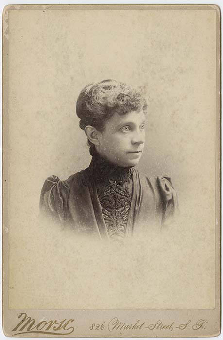
This street is named for Olive Julia Bell Stewart (1846–1921), daughter of William Nathaniel Bell and Sarah Ann Peter Bell. Belltown and Bell Street were named for her father, Virginia Street for her sister, and Stewart Street for her husband, Joseph. She was one of the younger members of the Denny Party, being five years old when they initially settled at Alki Point in 1851.
On September 3, 1920, The Seattle Times reported that:
Extension of Olive Street, by the establishment of a diagonal thoroughfare to be known as Olive Way, running from the intersection of Olive Street in a northeasterly direction to Boylston Avenue North and East Denny Way, is provided in an ordinance completed yesterday afternoon by the city engineer’s office…. The purpose of the whole improvement is to afford an east and west arterial highway, leading from the business district into the residence section of the city, supplementary to Pike Street and Pine Street.
According to the Seattle Post-Intelligencer’s June 24, 1923, issue, it “formally opened to traffic yesterday… a public improvement for which a fight extending over a period of fifteen years was waged,” so this 1920 ordinance was certainly not the first time an improved connection between Downtown and Capitol Hill was proposed. I’m not entirely sure what happened in 1908 the writer might have been referring to, but perhaps it was the Bogue Plan and he was off by a few years?
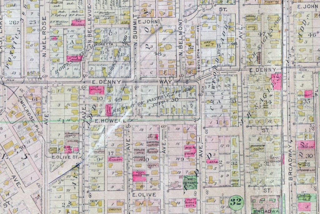
Portion of plate 7, Baist’s Real Estate Atlas of Seattle (1912), planned route of E Olive Way drawn in pencil. The portion of E Olive Street between Melrose and Bellevue Avenues is now E Olive Place.
It appears from the 1921 ordinance establishing the extension that the Olive Way name was originally only applied to the street east of Bellevue Avenue; it wasn’t until 1926 that it was extended west to the street’s origin.
One curiosity about E Olive Way addresses: the block numbers are out of sync with other east–west streets in the area. For example, the block east of Melrose Avenue is the 300 block, east of Bellevue Avenue the 400 block, east of Summit 500, east of Belmont 600, east of Boylston 700, etc. — for other streets. For E Olive Way, east of Melrose is 1300, east of Bellevue 1400 and 1500, east of Summit and Belmont 1600, east of Boylston 1700, etc. — essentially continuing on from Downtown, not starting over at what is now the route of Interstate 5, as the other streets do.
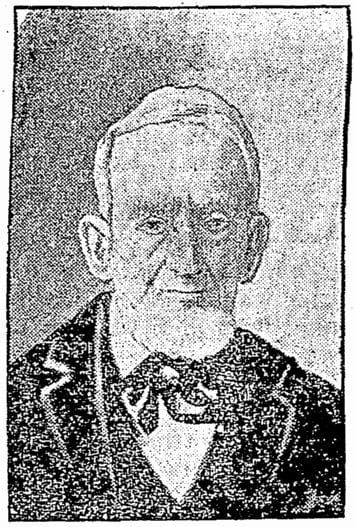
John Pike, from his obituary in the November 22, 1903, issue of The Seattle Times
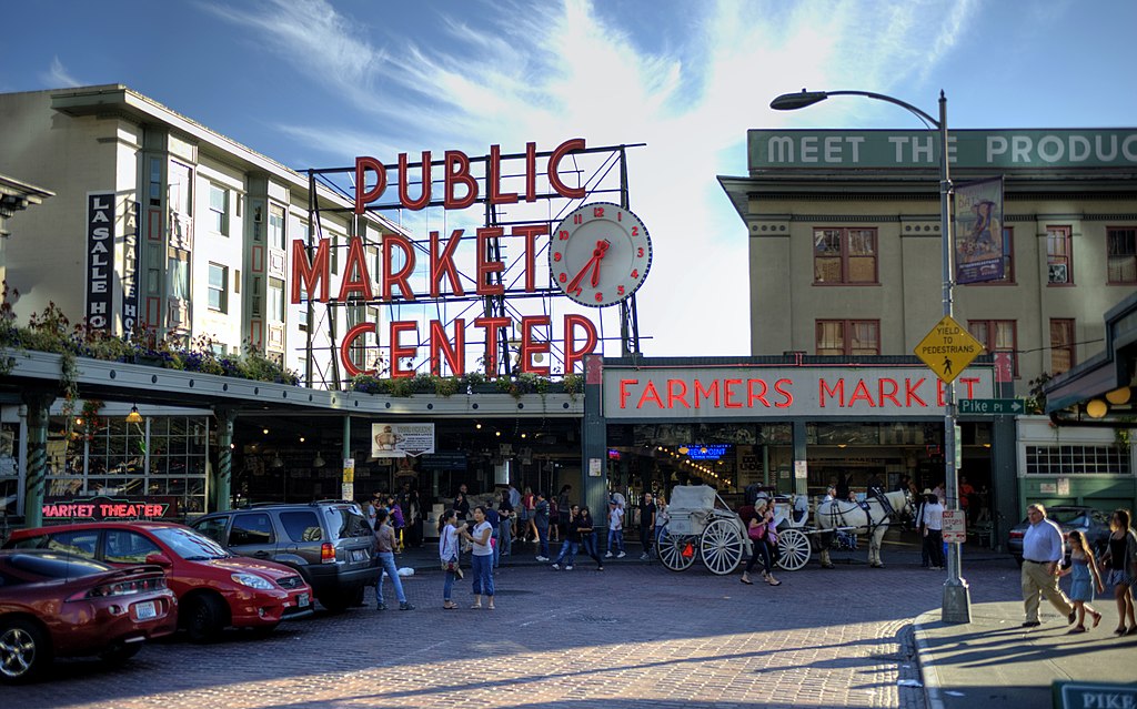
In the original plat, Pike Street (as well as Union and Pine Streets) begins at Front Street — today’s 1st Avenue — but today it begins on the Elliott Bay waterfront at Alaskan Way as the Pike Street Hillclimb. Pike Street proper begins at Pike Place (home of the eponymous market) and Post Alley (underneath the Market Theater sign), both shown below, and makes it a full 1⅔ miles to just past 18th Avenue in the Central District before being interrupted. It then resurfaces at 23rd Avenue and goes another ⅘ of a mile to Grand Avenue in Madrona, a few blocks east of Lake Washington.
This street, which is nowhere longer than a couple of blocks long, begins at 54th Avenue S in the east, just west of Andrews Bay and Seward Park, and finishes up at Corson Avenue S in the west, just east of Interstate 5.
According to Lucile Saunders McDonald, writing in The Seattle Times on January 1, 1956, it is named for Pearl Josephine Hulbert Faurote (1883–1981), granddaughter of Joseph and Catherine (Henderson) Dunlap (of S Henderson Street). I listed her as the street’s namesake when I originally posted this article. However, S Pearl Street is quite a bit north of Dunlap’s Plat of Land on Lake Washington — about 2¼ miles from Henderson. The name appears to have originated in Hillman City Division № 8, filed in 1903. As of May 19, 2021, neither I nor Valarie Bunn nor Rob Ketcherside nor Matt McCauley — who first called my attention to the fact that McDonald’s assertion was unsourced — have been able to find a connection between the Hillmans and anyone named Pearl. Nor does there appear to be any particular connection between the Hillmans and the Dunlaps or Hulberts, other than their all being active in Seattle real estate.
It seems, then, that the origin of Pearl Street should be regarded as an open question.
This fragmented street starts at Rainier Avenue S and travels two blocks west to 46th Avenue S. It makes its next appearance in Beacon Hill as a block-long street hanging off Military Road S, just east of Interstate 5. There are a few more blocks in South Park, from 5th to 2nd Avenues S, then half a block in West Seattle just west of California Avenue SW and a few final blocks from just east of Vashon Place SW to 47th Avenue SW at Lincoln Park. It is named for Fontanelle, Iowa, where Joseph and Catherine (Henderson) Dunlap (of S Henderson Street) lived before coming to Seattle in 1869.
Joseph and Catherine (Henderson) Dunlap arrived in the Puget Sound region in September 1869, having traveled by covered wagon from Iowa. According to family legend, when they arrived in the Puget Sound region, they followed a road over Beacon Hill and sent their son George up a tree to view the land to the south and east. There he spotted a flat valley and Lake Washington. The Dunlaps decided to homestead in that valley, located to the south of the Van Asselt and Mapel families. They claimed 120 acres extending east toward Rainier Beach.
Today, S Henderson Street begins at Seward Park Avenue S, just west of Be’er Sheva Park, and runs ¾ of a mile west to Carkeek Drive S. On the other side of Interstate 5 and the Duwamish River, it runs ⁹⁄₁₀ of a mile through South Park from just east of 14th Avenue S to just west of 2nd Avenue S, the portion over Highway 99/W Marginal Way S being a footbridge. Once in West Seattle, SW Henderson Street runs ⅔ of a mile from 8th Avenue SW, just west of Westcrest Park, to 21st Avenue SW, where the arterial turns into SW Barton Place, and is then a two-block residential street from 22nd Avenue SW to 25th Avenue SW, where it is blocked by the Westwood Village shopping mall. On the other side of the mall, it’s ⅘ of a mile from 28th Avenue SW to SW Barton Street at Fauntleroy Park, and then a final couple of blocks from 43rd Place SW to Fauntleroy Way SW, just north of Washington State Ferries’ Fauntleroy Terminal.
Among the representative business men of Seattle none are more deserving of representation in this volume than James Bothwell, who is now successfully engaged in the mortgage, loan, fire insurance business, and care of property and estates in that city.
Holman Road NW runs 1³⁄₁₀ miles from 15th Avenue NW just north of NW 87th Street to the intersection of Greenwood Avenue N and N 105th Street. For its last couple of blocks, it is Holman Road N. Work began on the diagonal street, then known as Holman Road № 1, in 1926 and was completed in 1929. (Holman Road № 2 is today known as Westminster Way N in Shoreline.)
The road’s namesake was Axel Holman (1867–1962), who according to various obituaries was born in Sweden and arrived in Seattle in 1886. A real estate agent and builder in later life, he, according to the July 4, 1962, issue of the Ballard News-Tribune, “built the Sunset Highway [and] helped to build the Milwaukee railroad through the Cascades” as a construction engineer. The March 10, 1947, issue of The Seattle Times reports that “against considerable opposition, Holman was instrumental in obtaining construction of Holman Road No. 1 and No. 2, near the northwest edge of Seattle, and he still has the loving cup presented to him in 1929 by the Ballard Commercial Club in recognition of that service,” and the July 2, 1962, issue of the same paper adds that he “owned a mine in Dawson City during the Gold Rush and in 1897 assisted in plotting the town-site of Skagway. He also laid the first wagon roadbed from Skagway through White Pass to the goldfields.”
Axel Holman, from March 10, 1947, issue of The Seattle Times
The house that was the subject of both articles, 5515 NE Latimer Place, was, according to county records, built in 1925, two years after Latimer’s death — perhaps he had intended to purchase it once it was completed but it was his family who ended up doing so? Or perhaps it was in fact built a few years earlier. At any rate, the Laurelhurst Blog says that “the Latimer Family… re-platted the grounds to be sold in the 1930’s, saving the 20,000+ square foot lot and carriage house for themselves.“ (The recent owner of the house quoted in the PSBJ as saying “Latimer named the street after himself and sub-divided the property” was incorrect, as this happened 12 years after his death.)
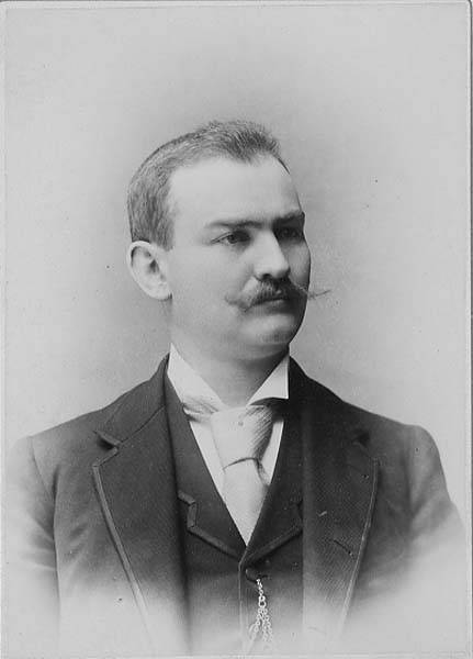
Norval Hastings Latimer, 1890. Photograph by Boyd and Braas.
This short street runs just over a tenth of a mile from 50th Avenue NE by St. Bridget Catholic Church in the northwest to NE 50th Street by Villa Academy in the southeast. It was established in 1913 as part of the Montlake Tracts addition by “Magdalena Nicklas, a widow.” Legal advertisements in The Seattle Republican newspaper in 1908 show her husband’s name to have been John Nicklas. Based on this article by Valarie Bunn, this FamilySearch page, this Find a Grave page, plus an item in the November 25, 1941, issue of the Seattle Post-Intelligencer, saying that 20 years earlier “the first woman to homestead on Sand Point, Mrs. Magdalena Nicklas, eighty-two, dies at her home,” we can expand the Nicklases’ biographical information to be Magdalena Kummer, 1839–1921, and Johann “John” Nicklas, 1834–1908, who were farmers in what is now Přimda, Czech Republic, but was then Pfraumberg, Austria–Hungary. They came to the United States in 1867 and to Seattle in 1878, and their land claim covered the 160 acres between what is now NE 45th Street on the south, NE 55th Street on the north, 45th Avenue NE on the west and 55th Avenue NE on the east.
Map of land claims in what is now Laurelhurst, from A History of Laurelhurst by Christine Barrett, published 1981.
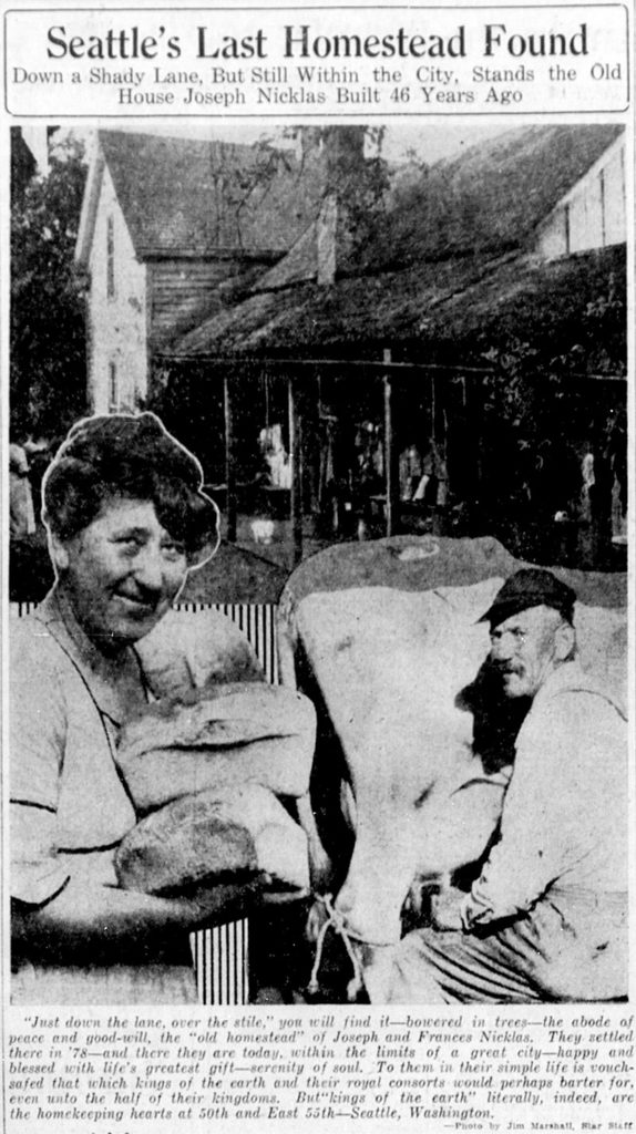
Joseph and Frances Nicklas featured in The Seattle Star, June 26, 1924. Joseph was the son of John and Magdalena, and was 17 when the family made their claim in 1878. The caption reads: “Just down the lane, over the stile,” you will find it — bowered in trees — the abode of peace and good-will, the “old homestead” of Joseph and Frances Nicklas. They settled there in ’78 — and there they are today, within the limits of a great city — happy and blessed with life’s greatest gift — serenity of soul. To them in their simple life is vouchsafed that which kings of the earth and their royal consorts would perhaps barter for, even unto the half of their kingdoms. But “kings of the earth” literally, indeed, are the homekeeping hearts at 50th and East 55th — Seattle, Washington. (That location is today where NE 55th Street, Ivanhoe Place NE, 50th Avenue NE, and NE Sand Point Way meet.)
This narrow street, which begins at 8th Avenue NW, snakes ⅔ of a mile west through a hilly, forested tract overlooking Puget Sound just north of Broadview Creek. It was established in 1940 as part of the Elford Park addition by Albert Sydney Elford (1867–1956) and his wife, Mae Caniff Elford (1877–1968), both originally from Ontario, Canada.
In Seattle and Environs, 1852–1924, by Cornelius Holgate Hanford, Albert S. Elford is described as “among the foremost representatives of insurance interests in the west,” having been transferred to Seattle in 1911 by the New York Life Insurance Company. He was also a director of the Dexter Horton National Bank; vice president, treasurer and a director of the Best Universal Lock Company; and a member of the First Methodist Episcopal Church, the Rainier Club, the Seattle Golf Club, the Rainier Golf and Country Club, the Elks, the Odd Fellows, and the Masons.
Unfortunately, Elford Park was among the far too many Seattle subdivisions that were created with racial restrictive covenants:
Tracts or parcels of land in this plat shall be used or occupied only by members of the white or Caucasian race, excluding Semites, and no other persons shall be permitted to use or occupy said tracts or parcels, except employees may occupy the premises where their employer resides.
This Queen Anne street runs a mere tenth of a mile north from McGraw Place alongside the Wolf Creek Ravine. As Michael Herschensohn, president of the Queen Anne Historical Society, writes, it was named in 1921 by and for builder John A. Lorentz (né Johan Amandus Lorentzson, 1879–1958), who came to the United States from Sweden in 1903.
This street runs not quite 300 feet from Martin Luther King Jr. Way S in the east to 42nd Avenue S in the west, just south of S Henderson Street. Like nearby Valdez Avenue S and Yukon Avenue S, it was established in 1905 as part of Dunlap’s Supplemental to the City of Seattle, and, in keeping with the Alaska theme, was named after the city of Fairbanks, which had been founded just four years earlier. (Fairbanks itself was named after Indiana Senator Charles Warren Fairbanks [1897–1905], who was vice president under Theodore Roosevelt from 1905 to 1909.)
This very short street (375 feet long) in the Dunlap neighborhood runs from Spear Place S in the south to S Henderson Street in the north. Like Valdez Avenue S, which it intersects, it was established in 1905 as part of Dunlap’s Supplemental to the City of Seattle, and was named after the Yukon River, likely due to the recent Klondike Gold Rush (ended 1899).
Yukon Avenue S, incidentally, holds the distinction of being the at the very end of the list of Seattle streets taken in alphabetical order — hence the tagline for Streets of Seattle, a blog from 2012 that sadly never seems to have gotten off the ground: “Seattle street names, from Adams to Yukon.”
This short street (just ⅛ of a mile long) connects Martin Luther King Jr. Way S to Yukon Avenue S in Seattle’s Dunlap neighborhood. Established in 1905 as part of Dunlap’s Supplemental to the City of Seattle, it was named after Valdez, Alaska, which was itself named after Spanish naval officer Antonio Valdés y Fernández Bazán. (Other streets in the plat include the above-mentioned Yukon Avenue as well as Tanana Drive, Fairbanks Drive, and Rampart Drive. Tanana Drive is now part of S Henderson Street; Fairbanks Drive is now S Fairbanks Street; and Rampart Drive is now part of S Director Street.)
I haven’t been able to find a specific connection the Hulbert or Dunlap families might have with Alaska, but 1905 was just six years after the Klondike Gold Rush ended, and just four years before the Alaska–Yukon–Pacific Exposition. Seattle’s population went from 42,837 in 1890 to 80,671 in 1900 — an increase of 88% — and much of this was due to its central role in the gold rush as “the premier supply centre and the departure point for the gold fields.”
California Avenue SW — a major West Seattle arterial connecting the Admiral, Alaska, and Morgan Junctions (three commercial hubs named after long-gone streetcar line intersections) — runs 4½ miles from California Lane SW in the north, past which it turns into California Way SW on its way down the hill to the waterfront, to SW Sullivan Street in the south. Beyond there it exists as a few short segments, then briefly as part of the SW Brace Point Drive–SW Barton Street arterial, and lastly as a nearly mile-long residential street that ends at Marine View Drive SW.


