This street is named for William Ashworth (1840–1906). According to the Haller Lake Community Club, Ashworth was born in England, emigrated to the United States in 1861, and came to Seattle in 1872.
Ashworth platted a town called Edgewater on the northern shore of Lake Union.… This area is now roughly the eastern part of Fremont and western portion of Wallingford.… Ashworth served as Edgewater’s only postmaster from 1889 until the area was annexed to Seattle two years later. As real estate development moved northward, so did the street bearing Ashworth’s name. Ashworth continued to live in Edgewater until his death in 1906.
Here is an article by local historian Paul Dorpat on Edgewater, on which it looks like I commented 13 years ago. And we learn both from the HLCC and Valarie Bunn of Wedgwood in Seattle History that the land on which berry farmer Ashworth’s home once stood is now the North Transfer Station (i.e., the city dump).
Today, Ashworth Avenue N begins at N 35th Street and goes ⅔ of a mile north to N 43rd Street. It resumes at N 55th Street and goes ¼ mile north to E Green Lake Way N, then begins again on the north side of the lake at Winona Avenue N and W Green Lake Drive N. From here, it goes another ⅔ of a mile to N 90th Street. Picking up again at N 92nd Street, it goes a further ⅞ of a mile to the Evergreen Washelli Cemetery at N 110th Street. It resumes one more time at N 120th Street and Stendall Drive N and goes 1¼ miles north to the city limits at N 145th Street, becoming a footpath for two short stretches west of Haller Lake. (As with many other North Seattle avenues, the name continues on into Shoreline; Ashworth Avenue N continues north of the city limits as far as N 200th Street, just south of the King–Snohomish county line at N 205th Street.)
Born and raised in Seattle, Benjamin Donguk Lukoff had his interest in local history kindled at the age of six, when his father bought him settler granddaughter Sophie Frye Bass’s Pig-Tail Days in Old Seattle at the gift shop of the Museum of History and Industry. He studied English, Russian, and linguistics at the University of Washington, and went on to earn his master’s in English linguistics from University College London. His book of rephotography, Seattle Then and Now, was published in 2010. An updated version came out in 2015.
This street was created in 1928 as part of the Golfcrest addition, named for the adjacent Jackson Park golf course that had opened earlier that year. Other named streets in the subdivision included Golfcrest Drive, Fairway Place, Bogey Place, and Tee Place. None of these streets exist any longer — Lakeside School moved to the neighborhood in 1930 and had the north portion of the plat vacated for its new campus, and the construction of Interstate 5 took out Golfcrest Drive in the mid 1960s.
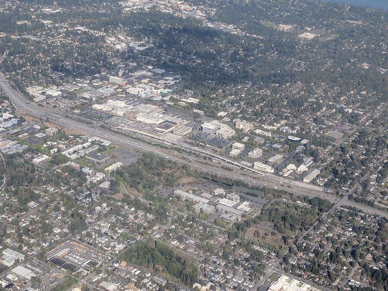
This northeast-looking aerial photo shows, from left to right (west to east), the Lakeside School campus (north portion of Golfcrest addition); Interstate 5; 5th Avenue NE; and the Jackson Park golf course. The overpass crossing I-5 is NE 145th Street (Washington State Route 523), which forms the boundary between Seattle to the south and Shoreline to the north. The Shoreline South/148th light rail station can be seen under construction just north of the overpass. Par Place itself is out of frame, to the south. Photograph by Flickr user Atomic Taco, September 26, 2021, licensed under Creative Commons Attribution-ShareAlike 2.0 Generic.
Par Place NE begins at NE 139th Street and goes ⅕ of a mile north to NE 140th Street, at the south end of the Lakeside campus.
Born and raised in Seattle, Benjamin Donguk Lukoff had his interest in local history kindled at the age of six, when his father bought him settler granddaughter Sophie Frye Bass’s Pig-Tail Days in Old Seattle at the gift shop of the Museum of History and Industry. He studied English, Russian, and linguistics at the University of Washington, and went on to earn his master’s in English linguistics from University College London. His book of rephotography, Seattle Then and Now, was published in 2010. An updated version came out in 2015.
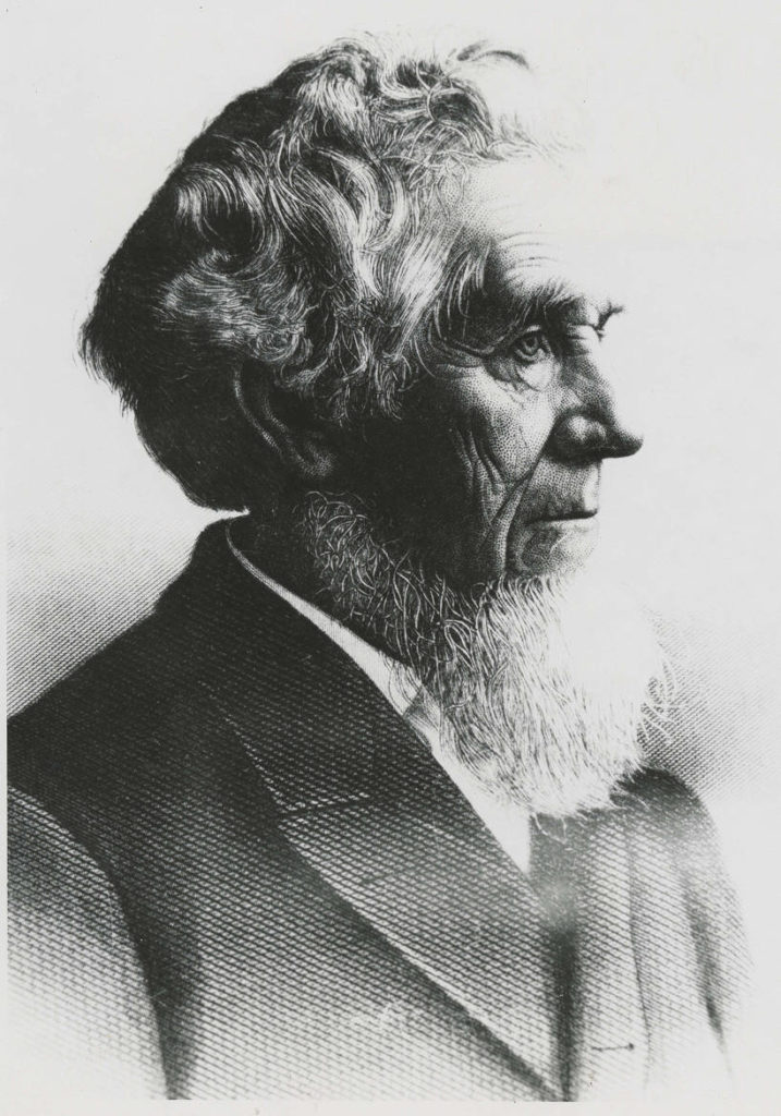
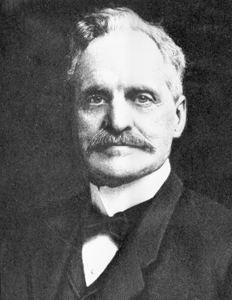
This street is named for Milton Densmore (1839–1908), a Civil War veteran from Chelsea, Vermont, who, according to Clarence Bagley’s History of Seattle from the Earliest Settlement to the Present Time, fought in the Battles of Fairfax Court House, Gettysburg, and Rappahannock Station. He returned to Vermont after the war, then moved to Beloit, Wisconsin, in 1867. Densmore came to Seattle in 1871. Sophie Frye Bass relates in Pig-tail Days in Old Seattle that he started out as “one of the captains of the Linna C. Gray, the stocky barge that carried coal from shore to shore in Lake Union.” In 1875, he opened a grocery, which closed in 1887. Bagley adds that
With various interests of Seattle he was closely associated. He laid the first steel rail for the street car system of Seattle, wooden rails having been used previous to that time. He served for two terms as a member of the city council and exercised his official prerogatives in support of various plans and measures for the general good. He served for seven years as a member of the school board and the cause of education found in him a stalwart champion. Densmore Avenue of Seattle was named in his honor and Seattle in many ways acknowledges her indebtedness to him. He did much toward improving property, built residences and otherwise aided in enhancing the attractiveness of the city and at all times was public spirited and active.
Milton Densmore, from the November 10, 1907, issue of the Seattle Post-Intelligencer. The story was about his reunion with his brother, Jason Densmore, whom he hadn’t seen in over four decades, since the Civil War ended (Jason was likewise a Union soldier from Vermont).
Densmore Avenue N begins at N Northlake Way, just north of Gas Works Park. It then goes ¾ of a mile north to the Wallingford Playfield at N 42nd Street. Resuming a block north, it goes a further ⅖ of a mile to N 50th Street. It picks up again at the north end of Green Lake, where Green Lake Drive N splits into W Green Lake Drive N and E Green Lake Drive N, and goes ⅗ of a mile to Cascadia Elementary School at N 90th Street. Densmore resumes at N 92nd Street and goes another ⅗ of a mile, past Licton Springs Park, to Mineral Springs Park at N 105th Street. It picks up again just north of N Northgate Way for a couple blocks before being stopped by Evergreen–Washelli Cemetery and UW Medical Center – Northwest. After a short segment north of the hospital, it then forms part of the ring arterial around Haller Lake, going ⅓ of a mile from N 122nd Street to N 128th Street, and finishes up with a ½-mile-long segment from Ingraham High School at N 135th Street to the city limits at N 145th Street. (As with many other North Seattle avenues, the name continues on into Shoreline; its northernmost appearance is between N 202nd Place and N 203rd Place, just south of the King–Snohomish county line at N 205th Street.)
Born and raised in Seattle, Benjamin Donguk Lukoff had his interest in local history kindled at the age of six, when his father bought him settler granddaughter Sophie Frye Bass’s Pig-Tail Days in Old Seattle at the gift shop of the Museum of History and Industry. He studied English, Russian, and linguistics at the University of Washington, and went on to earn his master’s in English linguistics from University College London. His book of rephotography, Seattle Then and Now, was published in 2010. An updated version came out in 2015.
This street was named in 1968 for Northgate Station, which opened in 1950 as the Northgate Center shopping mall. According to HistoryLink.org, it was “the country’s first regional shopping center to be defined as a ‘mall’ (although there were at least three predecessor shopping centers).” Newspaper archives show that it became known early on as Northgate Mall, and that became its official name in 1974. As of this writing, the property is in the midst of a massive redevelopment project that began in 2019.
Prior to 1968, Northgate Way was known as (from west to east) N 105th Street, Mineral Springs Way N, N 110th Street, NE 110th Street, and Chelsea Place NE. Today, it begins at N 105th Street and Aurora Avenue N and goes 2⅕ miles east to NE 113th Street and Lake City Way NE.
Digging into the newspaper archives, The Seattle Times of February 22, 1948, published a big spread on the plans for the shopping center. The story quoted one of the developers, a local investor named Ben Ehrlichman (the uncle of future Watergate figure John Ehrlichman). “The name Northgate was chosen, Ehrlichman [told The Seattle Times], because the development ‘will be the most important northerly business district serving Seattle and vicinity and the gateway to metropolitan Seattle.’” Though a 30th anniversary story in the same paper in 1980 credited Ehrlichman for coming up with the name — based on the 1948 story — we may never know for certain whose idea it was.
Aerial of Northgate, September 2018, looking northeast. Interstate 5 cuts across the photo from bottom right to upper left. To its west is North Seattle College; to its east is Northgate Station, the Thornton Place complex, the Northgate Transit Center, and the Northgate commercial district. The elevated tracks of Sound Transit’s Line 1 light rail can be seen just east of the freeway. The Lake City commercial district is visible to the northeast of the mall; the greenbelt closer to the mall is one of the forks of Thornton Creek. Photograph by Flickr user Atomic Taco, licensed under Creative Commons Attribution-ShareAlike 2.0 Generic
Born and raised in Seattle, Benjamin Donguk Lukoff had his interest in local history kindled at the age of six, when his father bought him settler granddaughter Sophie Frye Bass’s Pig-Tail Days in Old Seattle at the gift shop of the Museum of History and Industry. He studied English, Russian, and linguistics at the University of Washington, and went on to earn his master’s in English linguistics from University College London. His book of rephotography, Seattle Then and Now, was published in 2010. An updated version came out in 2015.
The meeting of 45th Street and Meridian Avenue began in the forest, when federal surveyors carrying their Gunter chains described — and marked — the future streets as the west (Meridian) and north (45th) borders for the 640 acres of federal land section number 17. That done, the settlers could identify their claims with some precision.
Indeed, King County’s quarter section map covering the intersection shows that (going clockwise) sections 7, 8, 17, and 18 of Township 25 North, Range 4 East, Willamette Meridian, meet there.
Meridian Avenue N begins at N Northlake Way just north of Gas Works Park and goes 1½ miles north to N 55th Street, where it becomes Kenwood Place N. It resumes at Kirkwood Place N just north of N 59th Street, and goes ¼ mile north to E Green Lake Way N. On the north side of the lake, there is a block-long stretch from E Green Lake Drive N to N 75th Street, and a longer, ¾-mile one from N 77th Street to N 92nd Street and North Seattle College. Meridian begins again at the north end of College Way N at N 103rd Street, and goes just under a mile to N 122nd Street, south of Haller Lake. It resumes on the north shore of the lake as a shoreline street end (though not on the city’s official list) and goes a mile north to the city limits at N 145th Street. As with most North Seattle avenues, the name continues into Shoreline, and in this case the arterial street itself keeps going for 3 more miles to the King–Snohomish county line at N 205th Street.
Born and raised in Seattle, Benjamin Donguk Lukoff had his interest in local history kindled at the age of six, when his father bought him settler granddaughter Sophie Frye Bass’s Pig-Tail Days in Old Seattle at the gift shop of the Museum of History and Industry. He studied English, Russian, and linguistics at the University of Washington, and went on to earn his master’s in English linguistics from University College London. His book of rephotography, Seattle Then and Now, was published in 2010. An updated version came out in 2015.
This street is named for Judge Thomas Burke (1849–1925), after whom the Burke–Gilman Trail and Burke Museum of Natural History and Culture are also named. In 1875, Burke, who was friends with the Bagley family, came to Seattle from Michigan, where he had attended law school. He began working with John McGilvra and ended up marrying his daughter, Caroline. He and Daniel Gilman were two of the founders of the Seattle, Lake Shore and Eastern Railway in 1885; the Burke–Gilman Trail today runs over the old railroad right-of-way. The Burke Museum, founded in 1885 by the Young Naturalists’ Society as Naturalists’ Hall, became the Washington State Museum in 1899 and took Burke’s name in the 1960s as part of a bequest from Caroline, who died seven years after her husband. He is also remembered for his defense of the rule of law during the period of peak anti-Chinese agitation in the 1880s. (He wanted the Chinese laborers to leave Seattle, but for this to happen non-violently, as opposed to what had happened in Tacoma.)
Thomas Burke, ca. 1910
Burke Avenue N begins at N Northlake Way and the Burke–Gilman Trail just north of Gas Works Park, and goes 1¼ miles north to N 50th Street. It resumes for a block at the north end of Green Lake between N 80th Street and N 82nd Street, and picks up again north of Bishop Blanchet High School at N 85th Street, going ⅓ of a mile north to N 92nd Street, where it becomes College Way N. With the exception of a few short segments, its next appearance is at N 135th Street, where it goes ½ a mile north to the city limits at N 145th Street. As with many other North Seattle avenues, the name continues on into Shoreline, and last appears as a short stub just north of N 203rd Street.
Born and raised in Seattle, Benjamin Donguk Lukoff had his interest in local history kindled at the age of six, when his father bought him settler granddaughter Sophie Frye Bass’s Pig-Tail Days in Old Seattle at the gift shop of the Museum of History and Industry. He studied English, Russian, and linguistics at the University of Washington, and went on to earn his master’s in English linguistics from University College London. His book of rephotography, Seattle Then and Now, was published in 2010. An updated version came out in 2015.
When I first posted this article, I wrote that Bagley Avenue N was named for Reverend Daniel Bagley (1818–1905) and his son, Clarence B. Bagley (1843–1932). That, after all, is what Sophie Frye Bass says in Pig-Tail Days in Old Seattle, which I pretty much took as gospel growing up. Junius Rochester says the same thing in his HistoryLink.org article on the Bagleys (using, I think, Pig-Tail Days as a reference.) And C.T. Conover (himself namesake of E Conover Court) repeats the story on two separate occasions for The Seattle Times — on February 18, 1950, and April 11, 1960.
However, today (September 10, 2021), I noticed that Conover had written a follow-up to his April 11 article. On April 25, 1960, he wrote that Clarence’s son, Colonel Cecil Clarence Bagley, had sent him a letter saying that, decades previous, he had asked his father if Bagley Avenue was named for his family. Daniel said no, it was named for Dr. Herman Beardsley Bagley (1845–1899). He had filed the plat of Bagley’s Addition in 1883. A small tract northeast of what is today Gas Works Park along the Lake Union shoreline, one of its streets was named Day Street. This later needed to be changed as it was duplicative of another Day Street elsewhere in the city. (I presume this is the S Day Street in Mount Baker that was almost entirely obliterated by the construction of what is now Interstate 90.) I can’t find the ordinance in question but, Conover continues, “as this was the central street in Dr. Bagley’s addition, it was considered appropriate to rename it Bagley Avenue in his honor, and that was done.”
The biography also says he was president for a time of the Seattle Improvement Company, which appears to be another name for the Lake Washington Improvement Company, one of many schemes to build what is today the Lake Washington Ship Canal. Jennifer Ott writes for HistoryLink.org that David T. Denny, along with Bagley and J. W. George, Corliss P. Stone, Thomas Burke, Frederick H. Whitworth, Benjamin F. Day, Erasmus M. Smithers, G. M. Bowman, Guy C. Phinney, John W. Van Brocklin, and William H. Llewellyn, formed the company in 1883, and, using Chinese laborers digging by hand, dug early versions of what are now the Fremont Cut and Montlake Cut.
Dr. Herman Beardsley Bagley
Even though it appears that Bagley Avenue N was not named for Daniel and Clarence Bagley, I’m leaving their biographical information as I originally wrote it, followed by the usual description of the street’s route.
The Bagleys came west in 1852 with, among others, Thomas Mercer and Dexter Horton, two other names familiar to those interested in Seattle history, but didn’t arrive in Seattle until 1860. The elder Bagley was one of the founders of the University of Washington in 1861; the younger was its first college student. Daniel Bagley also founded the Methodist Protestant “Little Brown Church” in 1865, so called to distinguish it from Seattle’s first church, the Methodist Episcopal “Little White Church.” (This church finally closed in 1993, by which time it had become the Capitol Hill United Methodist Church.) Clarence, who went on to marry one of Thomas Mercer’s daughters, is best remembered today for his multi-volume works on local history, including History of Seattle from the Earliest Settlement to the Present Timeand History of King County, Washington.
Daniel Bagley
Clarence B. Bagley
Bagley Avenue N begins at N 35th Street and N Pacific Street and goes a mile north to the Meridian Playground/Good Shepherd Center. It resurfaces north of Green Lake at E Green Lake Drive N and goes ½ a mile to N 85th Street. Besides a block-long stretch from N 106th Street to N 107th Street and another one north of N 133rd Street, it finishes up with a ¼-mile run from N 140th Street to the northern city limits at N 145th Street. Unlike many other North Seattle avenues, the name stops there and does not continue on into Shoreline, though there is a Bagley Drive N at the Ballinger Commons housing development.
Born and raised in Seattle, Benjamin Donguk Lukoff had his interest in local history kindled at the age of six, when his father bought him settler granddaughter Sophie Frye Bass’s Pig-Tail Days in Old Seattle at the gift shop of the Museum of History and Industry. He studied English, Russian, and linguistics at the University of Washington, and went on to earn his master’s in English linguistics from University College London. His book of rephotography, Seattle Then and Now, was published in 2010. An updated version came out in 2015.
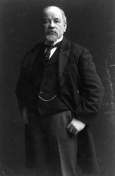
Wallingford Avenue and the Wallingford neighborhood are named for real estate developer John Noble Wallingford (1833–1913). Originally from Maine, he moved to Massachusetts, then Minnesota as a young man. He fought for the Union all four years of the Civil War, and later moved to California before coming to Seattle in 1888. He was a city councilman from 1889 to 1891 and also a police commissioner.
John Noble Wallingford, ca. 1893
Wallingford Avenue N begins as the Wallingford Steps at N Northlake Way, just north of Gas Works Park. It then goes 1⅔ miles north from N 34th Street to Woodlawn Avenue N, just south of Green Lake. At the north end of Green Lake, it goes 1⅓ miles north from E Green Lake Drive N to N 105th Street at Mineral Springs Park. It picks up again at N 135th Street, just north of Ingraham High School, and goes ½ a mile to the northern city limits at N 145th Street. As with many other North Seattle avenues, the name continues on into Shoreline; its northernmost appearance is at the King–Snohomish county line at N 205th Street.
Born and raised in Seattle, Benjamin Donguk Lukoff had his interest in local history kindled at the age of six, when his father bought him settler granddaughter Sophie Frye Bass’s Pig-Tail Days in Old Seattle at the gift shop of the Museum of History and Industry. He studied English, Russian, and linguistics at the University of Washington, and went on to earn his master’s in English linguistics from University College London. His book of rephotography, Seattle Then and Now, was published in 2010. An updated version came out in 2015.
Corliss Avenue N begins at N Northlake Way on the borth shore of Lake Union and goes nearly a mile north through Wallingford to the Good Shepherd Center just north of N 46th Street. There is another stretch from N 59th Street to N 65th Street in Green Lake. North of the lake, Corliss goes nearly another mile from East Green Lake Drive N to N 92nd Street and the North Seattle College campus. There are a few more segments through Haller Lake, the longest one being ¾ of a mile long from N 130th Street to the city limits at N 145th Street. As with other North Seattle avenues, the name continues on into Shoreline; its northernmost appearance is at N 194th Street.
Born and raised in Seattle, Benjamin Donguk Lukoff had his interest in local history kindled at the age of six, when his father bought him settler granddaughter Sophie Frye Bass’s Pig-Tail Days in Old Seattle at the gift shop of the Museum of History and Industry. He studied English, Russian, and linguistics at the University of Washington, and went on to earn his master’s in English linguistics from University College London. His book of rephotography, Seattle Then and Now, was published in 2010. An updated version came out in 2015.
At any rate, Ordinance 6947, filed on June 6, 1901, refers to the street as Aurora Street, and Ordinance 7942, filed on November 5 of that year, refers to it as Aurora Avenue. I can find no specific record of the name change, but Ordinance 6864, filed on May 8, has to do with “altering, defining and establishing the names of streets in the City of Seattle in the portion thereof lying north of Lake Union, Salmon Bay and the route of the Lake Washington Canal,” and is likely responsible. (No text is available online for the ordinance, and the drafters of Ordinance 6947 must have neglected to take the change into account.)
Aurora Avenue N might have remained just another North Seattle street were it not for the decision to route the Pacific Highway, U.S. Route 99, across the Lake Washington Ship Canal there instead of Stone Way N, Albion Place N, Whitman Avenue N, or Linden Avenue N. As it happened, Aurora was chosen as the location for the crossing (known today as the Aurora Bridge), and the name was officially extended through Queen Anne to Downtown Seattle in 1930 in preparation for the bridge’s opening in 1932.
Added July 14, 2023: I spoke to Feliks Banel of KIRO Newsradio for one of his All Over the Map segments, this one on how the Aurora Bridge got its name. I didn’t appear on air, but was mentioned in both the audio and web versions of the story.
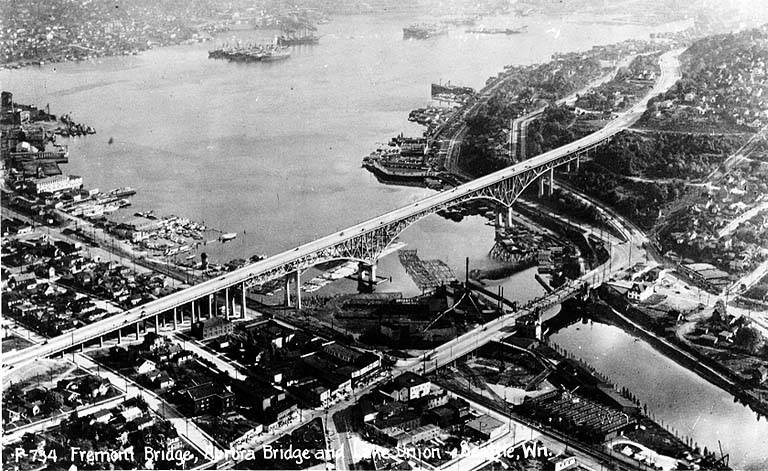
Postcard of Lake Union, Lake Washington Ship Canal, the Fremont Bridge, and the George Washington Memorial Bridge (Aurora Bridge), circa 1932. View looks southeast, with Fremont in foreground. Public domain image from University of Washington Libraries Digital Collections.Aurora Bridge, 2011. View looks east, with Gas Works Park and Wallingford neighborhood at center, Lake Union and Capitol Hill at right. Public domain photo by Flickr user Mike Linksvayer.
Today, Aurora Avenue N begins at 7th Avenue N and Harrison Street by the north portal of the State Route 99 Tunnel and goes 7⅘ miles north to the city limits; the name continues 3 further miles to the King–Snohomish county line, and the highway another 12 miles beyond that to Broadway in Everett. A block-long segment from 6th Avenue and Battery Street to Denny Way has been renamed Borealis Avenue, and Aurora between Denny Way and Harrison Street is once again 7th Avenue N. A two-block-long segment underneath the north approach to the Aurora Bridge has also been changed to Troll Avenue N.
Born and raised in Seattle, Benjamin Donguk Lukoff had his interest in local history kindled at the age of six, when his father bought him settler granddaughter Sophie Frye Bass’s Pig-Tail Days in Old Seattle at the gift shop of the Museum of History and Industry. He studied English, Russian, and linguistics at the University of Washington, and went on to earn his master’s in English linguistics from University College London. His book of rephotography, Seattle Then and Now, was published in 2010. An updated version came out in 2015.
This street runs nearly 6 miles from the north end of the University Bridge in the south (at Eastlake Avenue NE and NE Campus Parkway) to Aurora Avenue N in the north, just shy of Seattle city limits at N 145th Street. It runs north–south for most of its length, but starting at NE 125th Street, its last 1½ miles cut a northwest–southeast diagonal across the street grid, making it Roosevelt Way N once it crosses 1st Avenue NE between N 133rd and N 135th Streets.
Originally 10th Avenue NE south of NE 125th Street, Roosevelt received its current name in 1933. According to local historian Feliks Banel, this was first proposed in 1927 by businesses in the Roosevelt district, itself having taken that name earlier in the decade in honor of President Theodore Roosevelt, who died in 1919. Nothing came of it for six years, but in 1933 they tried again and asked that 10th Avenue be renamed after both Theodore and Franklin Delano Roosevelt, who had been elected president the previous November. As Banel notes in his piece, The Seattle Times had this to say:
This change, we assume, must be pleasing to local Democrats of all sorts and shades. At the same time, due to the incidence of somewhat tenuous family ties, it cannot be at all displeasing to Republicans. The name of Roosevelt has high standing in both political parties, as indeed it has throughout the world. Even now it is quite certain that those who may traverse our Roosevelt Way in years to come will neither know nor particularly care whether it was named for Teddy or for Frank.
As for its diagonal stretch, it appears on old King County maps as M. Roy Sayles Road (County Road 2240), Golf Way, and State Highway 1J (predecessor of today’s SR 513). It ceased to be a state highway in 1991. As for when it, too, became Roosevelt Way, it’s difficult to tell as King County doesn’t have as good a system for looking up ordinances online as Seattle’s. It appears as Roosevelt Way on a 1966 map in local historian Rob Ketcherside’s maps album on Flickr, but as Golf Way in another one from 1947. As the area in question wasn’t annexed into Seattle until 1953, the name must have been changed by the county sometime between 1947 and 1953 in anticipation. (The 1933 Seattle ordinance is the only one on file relating to Roosevelt Way’s name, so this must have been a county change.)
As for M. Roy Sayles, The International Confectioner’s January 1915 issue reports that he, along with Annie B. Sayles, C.M. Sayles, and W.H. Rogers, founded the Rogers Candy Co. in Seattle in 1915; and Golf Way almost certainly comes from the road’s proximity to the public course at Jackson Park, which opened in 1928.
Born and raised in Seattle, Benjamin Donguk Lukoff had his interest in local history kindled at the age of six, when his father bought him settler granddaughter Sophie Frye Bass’s Pig-Tail Days in Old Seattle at the gift shop of the Museum of History and Industry. He studied English, Russian, and linguistics at the University of Washington, and went on to earn his master’s in English linguistics from University College London. His book of rephotography, Seattle Then and Now, was published in 2010. An updated version came out in 2015.


