This street, like most others in Fort Lawton (1900−2011), which is now Discovery Park, was named by the United States Army after a state of the Union. I am not sure when the post’s streets were so named or who made the decision, but it can have been no later than 1944, when this map was made by the Army Corps of Engineers. (Here’s a much higher-resolution version from the Seattle Municipal Archives, created in 1973 but based on the older map.) One can see there that what are today Illinois Avenue and Bernie Whitebear Way were originally Vermont Way, Illinois Street, Lawton Road, and Florida Avenue. At some point before 1967 (see this map made by the Fort Lawton Office of the Post Engineer) the four were combined, and in 2011 the middle portion was renamed after Native American activist Bernie Whitebear.
Today, the eastern section of Illinois Avenue begins at Discovery Park Boulevard and goes ¼ of a mile north to Texas Way, where it turns into Bernie Whitebear Way. (Except for 45th Avenue W, no street in Discovery Park carries directional designations, nor did they when it was still a fort.) The western section, which is closed to traffic, begins at Texas Way and Discovery Park Boulevard and goes ¼ mile north to connect with footpaths that themselves connect to the North Beach Trail.
Born and raised in Seattle, Benjamin Donguk Lukoff had his interest in local history kindled at the age of six, when his father bought him settler granddaughter Sophie Frye Bass’s Pig-Tail Days in Old Seattle at the gift shop of the Museum of History and Industry. He studied English, Russian, and linguistics at the University of Washington, and went on to earn his master’s in English linguistics from University College London. His book of rephotography, Seattle Then and Now, was published in 2010. An updated version came out in 2015.
This street was created in 1895 as part of the Seattle Tide Lands plat (in full, Seattle Tide Lands as Surveyed and Platted by the Board of Appraisers of Tide and Shore Lands for King County, Washington). Streets were laid out from the northern tip of Magnolia (see W Semple Street) to West Seattle, but only the land southeast of Magnolia down to the Duwamish River was ultimately filled and developed.* (Magnolia’s tidelands were intended to become industrial land as part of the Bogue Plan, but this was rejected, and they have remained untouched west of the Elliott Bay Marina.)
As can be seen in the portion of the plat map reproduced below, the streets perpendicular to the shoreline in southwest Magnolia were named alphabetically after various cities in the United States. (Northwest of here, they were simply given letters of the alphabet, beginning with A and making it as far as O.) The namers began with Allegheny (Pennsylvania), and continued with Bangor (Maine), Chattanooga (Tennessee), Duluth (Minnesota), Erie (Pennsylvania), Fresno (California), Galveston (Texas), Hartford (Connecticut), Ithaca (New York), and our subject, Joliet (Illinois), before switching to yet another series.
Born and raised in Seattle, Benjamin Donguk Lukoff had his interest in local history kindled at the age of six, when his father bought him settler granddaughter Sophie Frye Bass’s Pig-Tail Days in Old Seattle at the gift shop of the Museum of History and Industry. He studied English, Russian, and linguistics at the University of Washington, and went on to earn his master’s in English linguistics from University College London. His book of rephotography, Seattle Then and Now, was published in 2010. An updated version came out in 2015.
At any rate, Ordinance 6947, filed on June 6, 1901, refers to the street as Aurora Street, and Ordinance 7942, filed on November 5 of that year, refers to it as Aurora Avenue. I can find no specific record of the name change, but Ordinance 6864, filed on May 8, has to do with “altering, defining and establishing the names of streets in the City of Seattle in the portion thereof lying north of Lake Union, Salmon Bay and the route of the Lake Washington Canal,” and is likely responsible. (No text is available online for the ordinance, and the drafters of Ordinance 6947 must have neglected to take the change into account.)
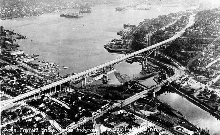
Aurora Avenue N might have remained just another North Seattle street were it not for the decision to route the Pacific Highway, U.S. Route 99, across the Lake Washington Ship Canal there instead of Stone Way N, Albion Place N, Whitman Avenue N, or Linden Avenue N. As it happened, Aurora was chosen as the location for the crossing (known today as the Aurora Bridge), and the name was officially extended through Queen Anne to Downtown Seattle in 1930 in preparation for the bridge’s opening in 1932.
Added July 14, 2023: I spoke to Feliks Banel of KIRO Newsradio for one of his All Over the Map segments, this one on how the Aurora Bridge got its name. I didn’t appear on air, but was mentioned in both the audio and web versions of the story.
Postcard of Lake Union, Lake Washington Ship Canal, the Fremont Bridge, and the George Washington Memorial Bridge (Aurora Bridge), circa 1932. View looks southeast, with Fremont in foreground. Public domain image from University of Washington Libraries Digital Collections.Aurora Bridge, 2011. View looks east, with Gas Works Park and Wallingford neighborhood at center, Lake Union and Capitol Hill at right. Public domain photo by Flickr user Mike Linksvayer.
Today, Aurora Avenue N begins at 7th Avenue N and Harrison Street by the north portal of the State Route 99 Tunnel and goes 7⅘ miles north to the city limits; the name continues 3 further miles to the King–Snohomish county line, and the highway another 12 miles beyond that to Broadway in Everett. A block-long segment from 6th Avenue and Battery Street to Denny Way has been renamed Borealis Avenue, and Aurora between Denny Way and Harrison Street is once again 7th Avenue N. A two-block-long segment underneath the north approach to the Aurora Bridge has also been changed to Troll Avenue N.
Born and raised in Seattle, Benjamin Donguk Lukoff had his interest in local history kindled at the age of six, when his father bought him settler granddaughter Sophie Frye Bass’s Pig-Tail Days in Old Seattle at the gift shop of the Museum of History and Industry. He studied English, Russian, and linguistics at the University of Washington, and went on to earn his master’s in English linguistics from University College London. His book of rephotography, Seattle Then and Now, was published in 2010. An updated version came out in 2015.
Cherry Street was among the first streets platted in Seattle on May 23, 1853. Sophie Frye Bass, author of Pig-Tail Days in Old Seattle, writes:
I choose to think that Cherry Street is named for the little town of Cherry Grove, Illinois — Mother’s birthplace — where the Dennys started on their long journey over the Oregon Trail.
In 2006, Hunter Brown wrote a People’s History essay for HistoryLink, “Finding Cherry Grove,” detailing his efforts to locate Cherry Grove, whose name was later changed to Cedar Township. The nearest town today is called Abingdon.
Bass began her Pig-Tail Days piece on Cherry Street by calling it “another up-and-up street… with no interferences. It begins at First Avenue, goes east and ends at Thirty-seventh avenue.” This is no longer quite the case because of a very small gap at the south end of the Seattle University campus. Today, Cherry begins at 1st Avenue and ends a block east of Broadway. It starts up again a couple hundred feet to the east as a continuation of the James Street/E James Way arterial, and then does go on to 37th Avenue in Madrona. All told it is 2⅓ miles long.
Born and raised in Seattle, Benjamin Donguk Lukoff had his interest in local history kindled at the age of six, when his father bought him settler granddaughter Sophie Frye Bass’s Pig-Tail Days in Old Seattle at the gift shop of the Museum of History and Industry. He studied English, Russian, and linguistics at the University of Washington, and went on to earn his master’s in English linguistics from University College London. His book of rephotography, Seattle Then and Now, was published in 2010. An updated version came out in 2015.