W Laurelhurst Drive NE

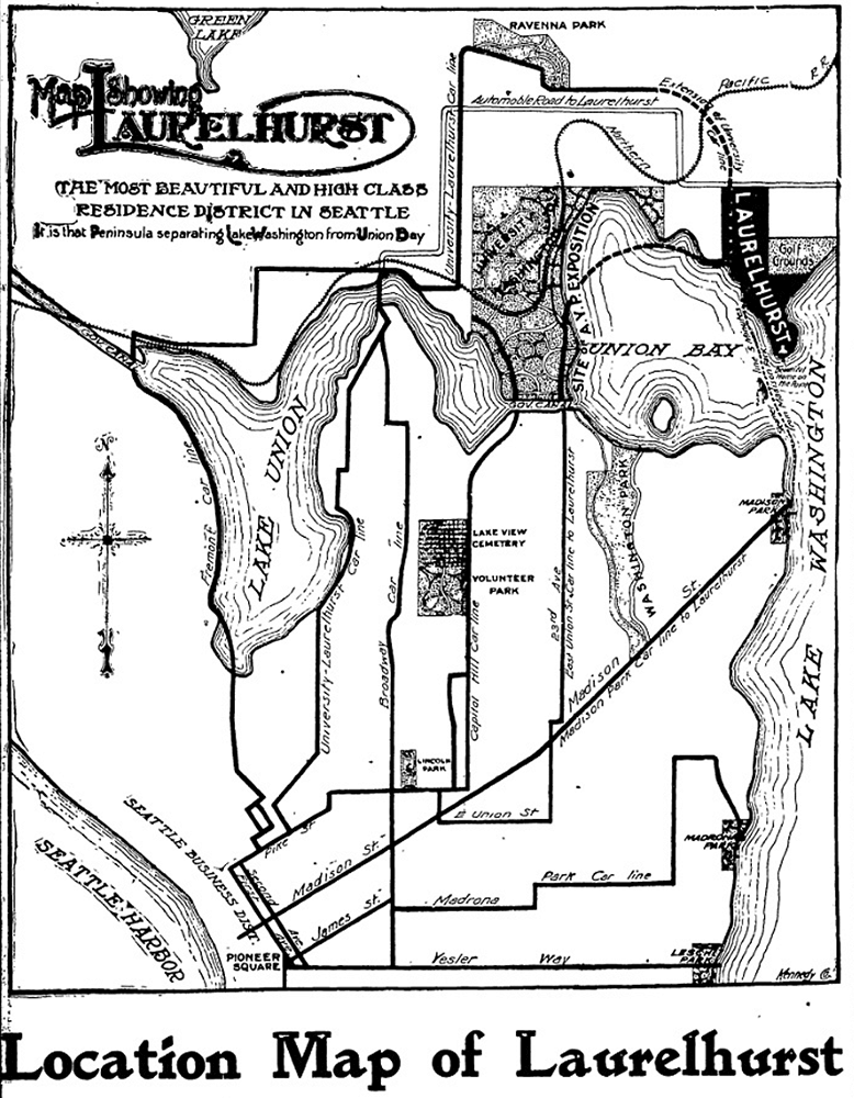
W Laurelhurst Drive NE and E Laurelhurst Drive NE were originally Olympic View Drive and Cascade View Drive, respectively, in the 1906 plat of Laurelhurst, an Addition to the City of Seattle. I am unable to tell exactly when the change was made: I first find “Laurelhurst Drive” being referred to in The Seattle Times in 1920, though a Kroll map from the same year shows the streets as 45th Avenue NE and 47th Avenue NE, respectively.

Laurelhurst itself was annexed to Seattle in 1910 (which makes me wonder why the plat was labelled as an addition to the city four years earlier). “Laurel” must refer to the tree, and “hurst” is an archaic word meaning “wooded hill.” However, as the English Language & Usage Stack Exchange thread that gives that definition notes, “in street names, [hurst is] likely to be a modern invention,” being part of “a name made up from old roots to imbue a sense of history and rootedness” (or, in cases like these, Britishness and stateliness). (I had thought that “Laurel” might refer to a girl or woman [cf. Loyal Avenue NW], but neither of the developers — Joseph Rogers McLaughlin [1851–1923] and Robert F. Booth [1875–1918] — appear to have had a relative by that name.)

(As an aside, the Wikipedia article on the Laurelhurst neighborhood in Portland, Oregon, citing Eugene E. Snyder’s 1979 Portland Names and Neighborhoods, says that “the name Laurelhurst was borrowed from a residential development in Seattle that Laurelhurst Company general manager Paul Murphy had recently completed. The name combined a reference to the laurel shrubbery near the Seattle development with the Old English hurst, denoting a wooded hill.” However, I have my doubts that there were actually enough laurels nearby to warrant the naming [in contrast to Magnolia, which was {mis}named for the plentiful madronas that lined the bluff].)

W Laurelhurst Drive NE begins at 43rd Avenue NE just south of NE 38th Street and goes ½ a mile southeast to just east of Webster Point Road NE, where it becomes E Laurelhurst Dr NE. From there, it goes nearly ⅖ of a mile northeast to a dead end just past 47th Avenue NE.

Aerial view of Laurelhurst from the south, 1938
Aerial view of Laurelhurst from the south, 1938. Webster Point dominates the view; W Laurelhurst Drive NE becomes E Laurelhurst Drive NE in front of the house that prominently appears at the southern end of the point. Photograph from the Seattle Post-Intelligencer Collection, Museum of History and Industry, licensed under Creative Commons Attribution 2.0 Generic
Map of Laurelhurst, Seattle Post-Intelligencer, October 21, 1906
Part of an advertisement for the new Laurelhurst subdivision, Seattle Post-Intelligencer, October 21, 1906. Laurelhurst is called “the most beautiful and high-class residence district in Seattle… that peninsula separating Lake Washington from Union Bay.” Prospective buyers were directed to take the Madison Street Cable Railway to its terminus at Madison Park, from which they could take a 5-minute ride on a steamer to Laurelhurst.

NE Belvoir Place

This street was created in 1926 as part of Belvoir, an Addition to the City of Seattle, filed by the executor of the estate of William Harvey “Uncle Joe” Surber (1834–1923) (Surber Drive NE). Surber had homesteaded what is now Laurelhurst in 1861, and an article in the September 19, 1926, issue of The Seattle Times noted that Belvoir was “one of the last, if not the last tract of land that [had] been held intact by its owners since pioneer days.”

Advertisement for Belvoir, The Seattle Times, September 17, 1926

NE Belvoir Place begins at Surber Drive NE and goes around 850 feet northeast to 41st Avenue NE. (There is also a park named Belvoir Place; located 1,000 feet to the southeast, it is a narrow parcel that stretches from 42nd Avenue NE to Union Bay.)

Surber Drive NE

This street is named after William Harvey “Uncle Joe” Surber (1834–1923), who came to Seattle from Indiana in 1859, having spent time in Missouri, California, and British Columbia along the way. Valarie Bunn tells his story in “From Yesler to Wedgwood,” and his Find a Grave page reproduces his biography from Clarence Bagley’s History of Seattle from the Earliest Settlement to the Present Time. In 1861, he established a homestead in what is now Laurelhurst, on what was then the east shore of Union Bay but is now Yesler Swamp. He was appointed the first sheriff of King County in 1866.

Originally 39th Avenue NE in the plat of Belvoir, an Addition to the City of Seattle, filed by his executor in 1926, it and E 37th Street became Surber Drive in 1939. Today, Surber Drive NE begins at NE 41st Street and goes around 700 feet to NE 38th Street, where it becomes NE Surber Drive and goes nearly 1,000 feet to 42nd Avenue NE.

Mary Gates Memorial Drive NE

This street, which runs ⅕ of a mile from the “five corners” intersection with NE 45th Street, NE 45th Place, and Union Bay Place NE in the northwest to NE 41st Street in the southeast, was created in 1911 as an extension of Union Bay Place. It was renamed in 1995 in honor of Mary Maxwell Gates (1929–1994), mother of Microsoft co-founder Bill Gates and a member of the University of Washington Board of Regents from 1975 to 1993.

The original proposal was to also change the name of NE 41st Street between Union Bay Place NE and Surber Drive NE to NE Mary Gates Memorial Drive, but this was not done. An article in the March 14, 1995, issue of The Seattle Times reports that “City Councilwoman Sue Donaldson said the Laurelhurst Community Club, the university and its neighbors near Union Bay Place Northeast joined yesterday in asking” for the name change, and an article in the September 1995 issue of Columns, then the name of the University of Washington alumni magazine, reports Donaldson as saying “The new name is particularly fitting… because it was the route Gates took from home to campus.”

I have never seen an explanation as to why the proposed name wasn’t simply Mary Gates Drive NE — it is the only “memorial” thoroughfare in town.

NE Latimer Place

This semicircular street, about 750 feet long, begins at NE 41st Street just west of 51st Avenue NE, and rejoins 41st just west of 55th Avenue NE. According to articles the Laurelhurst Blog and Puget Sound Business Journal, it was named for Norval Hastings Latimer (1863–1923), who had been president of the Dexter Horton National Bank. It was created in 1935.

The house that was the subject of both articles, 5515 NE Latimer Place, was, according to county records, built in 1925, two years after Latimer’s death — perhaps he had intended to purchase it once it was completed but it was his family who ended up doing so? Or perhaps it was in fact built a few years earlier. At any rate, the Laurelhurst Blog says that “the Latimer Family… re-platted the grounds to be sold in the 1930’s, saving the 20,000+ square foot lot and carriage house for themselves.“ (The recent owner of the house quoted in the PSBJ as saying “Latimer named the street after himself and sub-divided the property” was incorrect, as this happened 12 years after his death.)

Norval Hastings Latimer, 1890. Photograph by Boyd and Braas.

Nicklas Place NE

This short street runs just over a tenth of a mile from 50th Avenue NE by St. Bridget Catholic Church in the northwest to NE 50th Street by Villa Academy in the southeast. It was established in 1913 as part of the Montlake Tracts addition by “Magdalena Nicklas, a widow.” Legal advertisements in The Seattle Republican newspaper in 1908 show her husband’s name to have been John Nicklas. Based on this article by Valarie Bunn, this FamilySearch page, this Find a Grave page, plus an item in the November 25, 1941, issue of the Seattle Post-Intelligencer, saying that 20 years earlier “the first woman to homestead on Sand Point, Mrs. Magdalena Nicklas, eighty-two, dies at her home,” we can expand the Nicklases’ biographical information to be Magdalena Kummer, 1839–1921, and Johann “John” Nicklas, 1834–1908, who were farmers in what is now Přimda, Czech Republic, but was then Pfraumberg, Austria–Hungary. They came to the United States in 1867 and to Seattle in 1878, and their land claim covered the 160 acres between what is now NE 45th Street on the south, NE 55th Street on the north, 45th Avenue NE on the west and 55th Avenue NE on the east.

Map of land claims in what is now Laurelhurst, Seattle
Map of land claims in what is now Laurelhurst, from A History of Laurelhurst by Christine Barrett, published 1981.
Photograph of Joseph and Frances Nicklas, The Seattle Star, June 26, 1924
Joseph and Frances Nicklas featured in The Seattle Star, June 26, 1924. Joseph was the son of John and Magdalena, and was 17 when the family made their claim in 1878. The caption reads: “Just down the lane, over the stile,” you will find it — bowered in trees — the abode of peace and good-will, the “old homestead” of Joseph and Frances Nicklas. They settled there in ’78 — and there they are today, within the limits of a great city — happy and blessed with life’s greatest gift — serenity of soul. To them in their simple life is vouchsafed that which kings of the earth and their royal consorts would perhaps barter for, even unto the half of their kingdoms. But “kings of the earth” literally, indeed, are the homekeeping hearts at 50th and East 55th — Seattle, Washington. (That location is today where NE 55th Street, Ivanhoe Place NE, 50th Avenue NE, and NE Sand Point Way meet.)

Webster Point Road NE

This very short street in the Laurelhurst neighborhod — just over 200 feet long — was created in 1962 as part of the Webster Point plat. Why it’s a road rather than a place, lane, or court, I’m not sure — roads in Seattle (of which there aren’t many) are usually longer, such as Windermere Road NE, Holman Road NW, and Military Road S. It has the distinction of the lowest-numbered address on a north–south street north of the Lake Washington Ship Canal, as far as I am aware — 3000.

The plat and road are named for Webster Point, at the very southern tip of the Laurelhurst peninsula, which itself was named for Henry A. Webster, who once owned the land. This Webster appears to have been the Indian agent for the Makah tribe at Neah Bay on the Olympic Peninsula.