Wetmore Avenue S

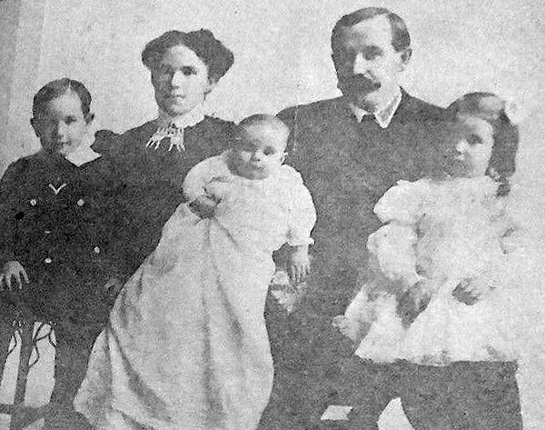
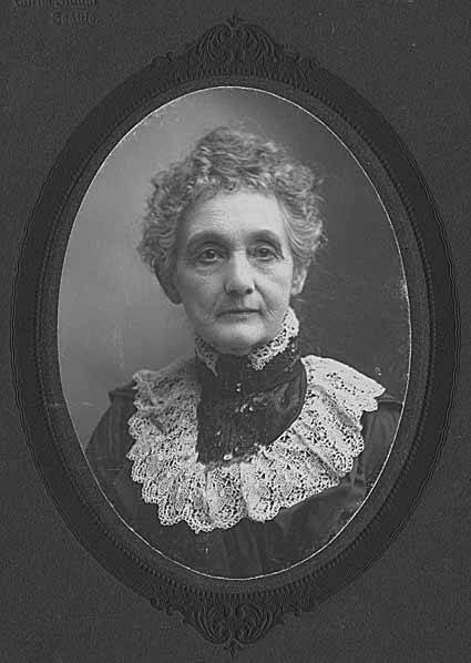
This street originates in the 1890 plat of the Byron Addition to the City of Seattle, filed by Byron Andrew Young (1845–1926) and his wife, Jane Wetmore Young (1850–1925). It would seem to be named after his wife’s maiden name, she being one of the children of Seymour Wetmore (1828–1897). Whether or not it was named after her or her father (a real possibility, as we’ll see) is unknown. (If her, that puts it in the same category as S Kenny Street, Sturgus Avenue S, Perkins Lane WThorndyke Avenue W, and Keen Way N.)

Wetmore “founded Seattle’s first tannery and shoe making business in 1855” with Milton Daniel Woodin (1800–1869), who was the father of his wife, Ann Woodin Wetmore (1829–1886). (Woodinville, located northeast of Seattle along the Sammamish River, was named after the Woodin family.) He homesteaded land in Rainier Valley, which later became the subject of a lawsuit against him by all his children except Jane. As the Seattle Post-Intelligencer reported on September 17, 1892,

Seymour Wetmore is an old settler in this section, who took up a government claim of 160 acres of land, which lies across the present line of the Rainier avenue electric railway. With the growth of Seattle Wetmore, by the increase of the values of property, found himself quite a wealthy man.… After the death of his wife her share was divided among the seven children, each of whom received $5,500. The amount that the father has kept for himself is now valued at about $25,000.… Last July a petition was filed… asking for the appointment of a guardian for Seymour Wetmore, on the ground that he was an habitual drunkard and incapable of taking care of himself.… The eldest son… swore to the petition, which set out that the father was addicted to dangerous excess in the use of intoxicating liquors, and was in the habit of going around in the company of lewd women and squandering his money.… [Wetmore] admitted that he drank. He had always been a drinking man and always would be. But he indignantly denied the charges that he associated with lewd women. By his answers he intimated that the… proceedings were due to a desire on the part of the children to tie up his property so that they would be sure of it in case of his death.

Finally, in February 1895, the matter was settled, as the Post-Intelligencer reported on the 28th under the headline ‘Seymour Wetmore Will Be Free to Squander His Wealth — He only yearns to spend it’. The article first recapped the origin of the lawsuit:

He felt as rich as any of the lords of creation, and worked himself up to the intoxication of enjoyment by spending money for the sole pleasure of seeing it go. He went about, his pockets lined with $20 pieces. This sort of thing grew tiresome to his prospective heirs, who became desperate on learning that Wetmore had entered into a deal with Byron Young, of Tacoma, whereby the latter received, in return for a bauble, $8,000 in money and 50 lots in Byron addition.

Excerpt from Seattle Post-Intelligencer article on Seymour Wetmore's guardianship case
Excerpt from Seattle Post-Intelligencer article, from February 28, 1895, issue on Seymour Wetmore’s guardianship case, in which Wetmore argues for his right to do whatever he wants with his money, including destroying it

The case dragged on for a while, but, as it turns out,

Pending the decision of the supreme court the property involved had been transferred and retransferred again and again until an abstract of title would make a formidable document. In consequence the case of [Wetmore’s guardian] vs. Young was dismissed by stipulation in the equity department last Saturday. There is now nothing left to fight over, and the inevitable conclusion is that the aged ward will be found able to take care of himself.

Wetmore Avenue S begins at 30th Avenue S just south of S Hanford Street, crosses S Byron Street, and goes 800 feet southeast to S Walden Street. There is another short segment — around 150 feet long — south of S Estelle Street, which turns into a footpath of about equal length connecting to S Spokane Street.

S Kenny Street

This street was created in 1903 as part of the plat of Hillman City Division № 5, filed by real estate developer Clarence Dayton Hillman (1870–1935) and his wife, Bessie Olive Kenny (1879–1947). Hillman also named the Renton neighborhood of Kennydale after his wife’s maiden name.

S Kenny Street begins on Beacon Hill at 21st Avenue S and goes two blocks east to 23rd Avenue S. It resumes in Hillman City at 42nd Avenue S and goes ¼ mile east to a dead end east of Rainier Avenue S. Its final segment, just under 400 feet long, lies west of 51st Avenue S and dead-ends at some private driveways.

C.D. Hillman, Bessie Kenny Hillman, and family
Bessie and C.D. Hillman and family, from a 1910 abstract of title for C.D. Hillman’s Birmingham Water Front Addition to the City of Everett
Bessie and C.D. Hillman
Bessie and C.D. Hillman and children, n.d., courtesy of his great-granddaughter

Sturgus Avenue S

This street was created in 1900 as part of the plat of the Orchard Hill Addition, filed by Martin Dean, Sarah J. Dean, Elizabeth H. Lewis, William H. Lewis, the W.C. Hill Brick Company, and the First National Bank of Seattle. According to Don Sherwood, it was named for John J. Sturgus, “realtor and agent of [the] W.C. Hill Estate” (Hill had died in 1890).

I do find mentions of a John J. Sturgus, associated with the Hill Company or the Hill Estate, in a number of Polk directories. However, it appears a Dr. John J. Sturgus (1859–1907) was also the brother of Hill’s wife, born Alice Bradley Sturgus (1847–1904).

Article in the (Washington, D.C.) Evening Star, September 9, 1890, on the death of W.C. Hill
Article in the (Washington, D.C.) Evening Star, September 9, 1890, on the death of W.C. Hill, mentioning Mrs. Hill’s mother (“Mrs. Sturgus”) and brother (Dr. John J. Sturgus).

Given the unlikelihood of two completely different John J. Sturguses being associated with the Hills, I’m going to assume that the physician and real estate man were one and the same, and that the street was given its name either because Dr. Sturgus was Hill’s brother-in-law or because Sturgus was his wife’s maiden name (or both). If the latter, that puts it in the same category as Perkins Lane W, Thorndyke Avenue W, and Keen Way N.

Today, Sturgus Avenue S begins at S Charles Street, just east of the Jose Rizal Bridge, and goes ½ a mile southeast, then south, to S State Street. The right-of-way continues a block further, to the S Grand Street right-of-way, but houses with addresses on that block are accessed by a private alley north of 16th Avenue S.

Keen Way N

This street originates in the 1924 plat of Winona Park, an Addition to the City of Seattle, filed by George Emerson Morford (1890–1946) and his wife, Gertrude Alice Keen Morford (1892–1954). According to Florence Helliesen of the Queen Anne Historical Society, George was president of the F.W. Keen Company, a real estate firm owned by his father-in-law, Frederick Walter Keen (1855–1929). The Seattle Civil Rights & Labor History Project writes:

Two real estate firms, F.W. Keen Company and J.L. Grandey, Inc., organized most of the racial restrictive covenants for Queen Anne from 1928 to 1931… specifying that “No person or persons of Asiatic, African or Negro blood, lineage, or extraction shall be permitted to occupy a portion of said property, or any building thereon; except domestic servants may actually and in good faith be employed by white occupants of such premises.”

In addition to being president of F.W. Keen, George Morford was vice president of J.L. Grandey.

Which Keen was honored by Keen Way N — Gertrude Alice Keen Morford, Frederick Walter Keen, or the F.W. Keen Company — isn’t clear; if it was for George Morford’s wife, that would put Keen Way in the same category as Perkins Lane W and Thorndyke Avenue W.

Keen Way N begins at Aurora Avenue N between W Green Lake Drive N and Winona Avenue N and goes ⅕ of a mile northeast to N 76th Street.

Frederick Walter Keen, from his Seattle Times obituary, August 14, 1929
Frederick Walter Keen, from his Seattle Times obituary, August 14, 1929. I was unable to locate a photograph of his daughter, Gertrude.

Perkins Lane W

This Magnolia street boasts one of the best views in all of Seattle — a completely unobstructed vista of Elliott Bay, Puget Sound, the Kitsap Peninsula, and the Olympic Mountains — if you’re fortunate enough to own property there. The view from the street itself is mostly of houses to the west, forested slope to the east. Notable Seattleites such as developer Martin Selig, broadcaster Kathi Goertzen, musician Ryan Lewis, and co-founder of Starbucks and Redhook Ale Brewery Gordon Bowker have called the winding lane — and it truly is a winding lane, hugging the bluff with barely enough room for two cars to pass each other — home.

View of Perkins Lane, Elliott Bay, and West Seattle from Discovery Park
View of Perkins Lane houses from Discovery Park, with Elliott Bay and West Seattle in background, January 2021. Photograph by Joe Mabel, Wikimedia Commons, licensed under Creative Commons Attribution-ShareAlike 4.0 International

The street was created as part of Carleton Beach Tracts, an Addition to the City of Seattle, Washington, on New Year’s Eve, 1920. The owners were Arthur Alexander Phinney (1885–1941), son of Guy Carleton Phinney, after whom Phinney Ridge and Phinney Avenue N are named; his wife, Daisy Euphemia Phinney (1884–1950); the Phinney Realty and Investment Company; and Oscar E. Jensen & Co., Inc. It begins at W Emerson Street in the north, just south of Discovery Park, and goes 1⅖ miles southeast to a roadblock a few feet beyond the bottom of the Montavista Stairs (more on that later). The roadway continues about 250 feet past the roadblock — all the buildings and lots on the west side belong to Martin Selig — and the right-of-way continues a little over 800 feet beyond that (see below for why).

The lane’s namesake had been a mystery to me for a long time, until I came across the Phinneys’ wedding announcement in the May 11, 1913, issue of the Seattle Post-Intelligencer:

Formal announcement made yesterday of the marriage at Victoria, B.C., May 2, of Miss Daisy E. Perkins, of Portland, to Mr. Arthur A. Phinney, of Seattle, contained the first intimation to local friends of Mr. Phinney of the nuptial event. The bride and groom had laid their plans in secret and protected this secret against all inquiring friends.

It seems, then, that we have a case similar to that of Thorndyke Avenue W — naming a prominent street after the wife’s maiden name.

For all its advantages, though — view, privacy (though it’s a public street, there are only a couple of ways to drive there from the rest of the city, plus two rickety staircases down from Magnolia Boulevard) — Perkins Lane has its faults, as the headline ‘Perkins Lane: Seattle’s Poster Child for Landslide Risk’ implies. A major landslide at the end of 1996 took out five or six houses, depending on whom you ask, at the southeast end of the street, and the adjoining roadway — hence the aforementioned roadblock. A lawsuit against the city, of course, was filed, but was dismissed at summary judgment. Slides had been a problem for the seven decades of Perkins Lane’s existence before that, as the images below attest. (The statute of limitations for false advertising has long elapsed, alas…)

Perkins Lane Slide at W. Ray St. (displacement of utility poles), March 22 1925, from http://archives.seattle.gov/digital-collections/index.php/Detail/objects/77613, Seattle Municipal Archives Identifier 38072
Landslide at W Raye Street, with tilting utility pole, March 22, 1925. Courtesy of the Seattle Municipal Archives, Identifier 38072
Sign reading "For sale by owner — best buy, best view on Perkins Lane — No slides — Civil engineer says "Good condition to build on" — ME. 3843, MA. 8847 — 150 ft. frontage — will divide" at 2461 Perkins Lane W
Land for sale! Who was that civil engineer, I wonder…
“No slides — Civil engineer says ‘Good condition to build on,’” 2461 Perkins Lane W, April 14, 1938. Courtesy of the Seattle Municipal Archives, Identifier 12194
Landslide at 2445 Perkins Lane W
Landslide at 2445 Perkins Lane W, January 27, 1954. Courtesy of the Seattle Municipal Archives, Identifier 44997
Ruins of house destroyed in Perkins Lane landslide on Magnolia beach in front of Magnolia bluff
Ruins of house destroyed in Perkins Lane landslide on Magnolia beach in front of Magnolia bluff, Photograph by Flickr user Whitney H, licensed under Creative Commons Attribution-NonCommercial-NoDerivs 2.0 Generic

In fact, as the map below shows, there have been numerous slides over the years along the entire length of the road.

Perkins Lane W is also home to six of Seattle’s shoreline street ends — at W Bertona, Dravus, Barrett, Armour, Raye, and McGraw Streets, though McGraw is the only one currently accessible from land. The project to improve it back in 2013 and 2014 was not without opposition, but ultimately the threats never materialized (nor did the opponents’s fears). It’s well worth a visit.

View looking south from the W McGraw street end: Elliott Bay, Puget Sound, and West Seattle
View looking southeast from the W McGraw street end: Elliott Bay, Puget Sound, and West Seattle, November 5, 2014. Photograph by Flickr user Seattle Parks and Recreation, licensed under Creative Commons Attribution 2.0 Generic
Fourmile Rock by Wikimedia Commons user Dennis Bratland, from https://commons.wikimedia.org/wiki/File:Fourmile_Rock,_Magnolia_at_low_tide,_with_yardstick.JPG, licensed under https://creativecommons.org/licenses/by-sa/4.0/deed.en, April 6, 2015
Fourmile Rock (native name reportedly LE’plEpL, La’pub, or Tc!ě’tla), northwest of the W McGraw street end, April 6, 2015. Photograph by Dennis Bratland, Wikimedia Commons, licensed under Creative Commons Attribution-ShareAlike 4.0 International

Thorndyke Avenue W

This street was named for Grace Chalmers Thorndike (, who married Daniel Hunt Gilman (Gilman Avenue W) in 1888. It was created in 1890 as part of Gilman’s Addition to the City of Seattle. The original plan was that Gilman and Thorndyke Avenues would intersect each other at Grand Boulevard (now W Dravus Street), but this was changed, as can be seen in the plat map below, likely in the knowledge that the tracks of the Seattle, Lake Shore and Eastern Railway would soon multiply and make that impractical.

Gilman's Addition to Seattle, 1890, two sheets stitched together
Gilman’s Addition to Seattle, 1890

It’s not entirely clear why the street is named Thorndyke rather than Thorndike. There was an announcement of the Gilman–Thorndike wedding in the January 15, 1888, issue of the Seattle Post-Intelligencer that spelled the name with a y, but otherwise the family’s name routinely appears in the Seattle press with an i. Yet we see that Grace’s sister Minnie — wife of James Bothwell (W Bothwell Street) — spelled her name with a y (at any rate, that is what appears on her tombstone).

(It’s also worth noting that Grace’s sister Estella married Captain William Rankin Ballard, after which the Ballard neighborhood is named, and her sister Delia married Ballard’s business partner Captain John Ayres Hatfield. The Thorndikes’ father was himself a ship’s captain, one Ebenezer Augustus Thorndike.)

Today, Thorndyke Avenue W begins at W Galer Street, at the west end of the Magnolia Bridge, and goes just over a mile northwest to 20th Avenue W and W Barrett Street. It picks up again as a minor road on the other side of the BNSF Railway tracks, going about ⅕ of a mile northwest from 17th Avenue W and W Bertona Street to a dead end under the 15th/Emerson/Nickerson overpass at the south end of the Ballard Bridge.

Conkling Place W

This street runs just over a thousand feet from 10th Avenue W and W Bertona Street in the northwest to 8th Avenue W and W Dravus Street in the southeast. It was named after Susan Conkling Prosch, mother of Thomas Prosch, who filed Prosch’s Queen Anne Addition to the City of Seattle in 1909. (Prosch was a noted local journalist and historian, who didn’t neglect to name Prosch Avenue W after himself.)

Susan Conkling Prosch, 1897

Conkling Place was one of the streets retained when George E. Morford and Gertrude Keen Morford filed their plat of Queen Anne Park in 1926. The Queen Anne Historical Society has an extensive article on the latter subdivision, which was among those in Seattle with all-too-common racial restrictive covenants, in this case excluding Blacks and Asians.

Portion of Prosch's Queen Anne Addition to the City of Seattle, 1909
Portion of Prosch’s Queen Anne Addition to the City of Seattle, 1909.