Triton Drive NW begins at 28th Avenue NW and NW 96th Street and goes around 870 feet northeast to an intersection with NW Esplanade, where it becomes NW Blue Ridge Drive.
Born and raised in Seattle, Benjamin Donguk Lukoff had his interest in local history kindled at the age of six, when his father bought him settler granddaughter Sophie Frye Bass’s Pig-Tail Days in Old Seattle at the gift shop of the Museum of History and Industry. He studied English, Russian, and linguistics at the University of Washington, and went on to earn his master’s in English linguistics from University College London. His book of rephotography, Seattle Then and Now, was published in 2010. An updated version came out in 2015.
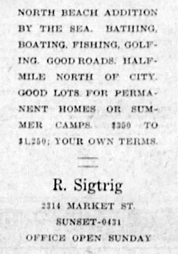
This street was established in 1926 as part of North Beach, an Addition to the City of Seattle. As the advertisement below indicates, the addition features excellent views of Puget Sound. I assume Neptune being the Roman god of the sea was the inspiration behind the name.
Advertisement for the North Beach Addition in the September 17, 1925, issue of The Seattle Star
NW Neptune Place begins at NW Blue Ridge Drive and NW 100th Street and goes around 650 feet southeast to NW 98th Street and 24th Avenue NW.
Born and raised in Seattle, Benjamin Donguk Lukoff had his interest in local history kindled at the age of six, when his father bought him settler granddaughter Sophie Frye Bass’s Pig-Tail Days in Old Seattle at the gift shop of the Museum of History and Industry. He studied English, Russian, and linguistics at the University of Washington, and went on to earn his master’s in English linguistics from University College London. His book of rephotography, Seattle Then and Now, was published in 2010. An updated version came out in 2015.
Born and raised in Seattle, Benjamin Donguk Lukoff had his interest in local history kindled at the age of six, when his father bought him settler granddaughter Sophie Frye Bass’s Pig-Tail Days in Old Seattle at the gift shop of the Museum of History and Industry. He studied English, Russian, and linguistics at the University of Washington, and went on to earn his master’s in English linguistics from University College London. His book of rephotography, Seattle Then and Now, was published in 2010. An updated version came out in 2015.
Loyal Way NW begins at 28th Avenue NW and NW 80th Street and goes just over ⅓ of a mile northwest to 32nd Avenue Northwest and NW 85th Street, following the route of the Loyal Electric Street Railway that Treat built in 1907.
Born and raised in Seattle, Benjamin Donguk Lukoff had his interest in local history kindled at the age of six, when his father bought him settler granddaughter Sophie Frye Bass’s Pig-Tail Days in Old Seattle at the gift shop of the Museum of History and Industry. He studied English, Russian, and linguistics at the University of Washington, and went on to earn his master’s in English linguistics from University College London. His book of rephotography, Seattle Then and Now, was published in 2010. An updated version came out in 2015.
This street was named as part of the 1907 plat of Loyal Heights, filed by Edward B. Cox and Harry Whitney Treat, and Treat’s wife, Olive Marion Graef Treat. Then, as now, the lots abutted a wooded (“sylvan”) area surrounding an unnamed creek that begins between Golden Gardens Drive NW and Forest Hill Place NW just north of NW 87th Street and flows to Puget Sound, heading into a culvert just south of Whitney Place NW and continuing under NW Esplanade and the BNSF Railway mainline to the privately owned North Beach.
Sylvan Place NW begins at the intersection of Loyal Avenue NW and Golden Gardens Drive NW and goes around 400 feet northeast, where it turns into Cyrus Avenue NW.
Born and raised in Seattle, Benjamin Donguk Lukoff had his interest in local history kindled at the age of six, when his father bought him settler granddaughter Sophie Frye Bass’s Pig-Tail Days in Old Seattle at the gift shop of the Museum of History and Industry. He studied English, Russian, and linguistics at the University of Washington, and went on to earn his master’s in English linguistics from University College London. His book of rephotography, Seattle Then and Now, was published in 2010. An updated version came out in 2015.
This street was named for Carkeek Park, which encompasses 216 acres in the Broadview neighborhood, including Pipers Creek and nearly ½ a mile of Puget Sound waterfront (though the usable beach is much shorter, as the main line of the BNSF Railway cuts off public access to the rest). It was one of the “46 new street names to simplify street addresses” The Seattle Times reported on in its issue November 6, 1960, and was made up of “Sixth Avenue Northwest from West 110th to West 111th Streets, West 111th Street from Sixth to Seventh Avenues Northwest, Seventh Avenue NW from West 111th to West 114th Streets, and West 114th Street from Seventh Avenue NW to West 116th Street.” (Part of this route was once Puget Drive, part of the 1911 View-Lands Addition.)
Morgan Carkeek, 1910Emily Carkeek, 1911
The park itself opened in 1929 and was named for Morgan James Carkeek (1847–1931) and his wife, Emily Gaskill Carkeek (1852–1926). According to the Museum of History & Industry, “Morgan… was an accomplished stonemason and successful building contractor who built several of Seattle’s early stone buildings, such as the Dexter Horton Bank, and large office buildings, including the Burke and Haller buildings.” In 1918, he and Emily donated land to the city for the first Carkeek Park, located along Lake Washington where Magnuson Park is today, but soon thereafter plans were made to develop Naval Air Station Seattle on the land, and the park was taken over by the Navy in 1926. The Carkeeks donated $25,000 to the city to purchase land elsewhere, and with the addition of $100,000 in public funds the city was able to buy Piper’s Canyon.
Report in The Seattle Times, May 28, 1927, on the Carkeeks’ contribution of funds to buy Piper’s Canyon. The Seattle Historical Society, which they had a hand in founding, never did build a museum in Carkeek Park, but ended up building the Museum of History & Industry in Montlake’s McCurdy Park instead. MOHAI opened in 1952 and moved to Lake Union Park in 2012 after having to make way for the expansion of Washington State Route 520.
NW Carkeek Park Road begins at NW 110th Street and Puget Drive NW and winds ½ a mile northwest to the entrance to Carkeek Park at NW 114th Street. Within the park, it goes a further ½ mile west, ending at a parking lot, picnic area, and playground. (This portion appears to have once been known as Piper’s Canyon Road or Pipers Road.) From here, there is a bridge over the BNSF Railway tracks to a beach along Puget Sound and the mouth of Pipers Creek.
Aerial view of Carkeek Park, looking southeast, July 9, 1969. The valley and outlet of Pipers Creek are clearly visible, as is the main line of the BNSF Railway that separates the park’s wooded and grassy areas from Puget Sound. Courtesy of the Seattle Municipal Archives, Identifier 77628.
Born and raised in Seattle, Benjamin Donguk Lukoff had his interest in local history kindled at the age of six, when his father bought him settler granddaughter Sophie Frye Bass’s Pig-Tail Days in Old Seattle at the gift shop of the Museum of History and Industry. He studied English, Russian, and linguistics at the University of Washington, and went on to earn his master’s in English linguistics from University College London. His book of rephotography, Seattle Then and Now, was published in 2010. An updated version came out in 2015.
This street, originally W 93rd Street in the 1907 plat of Loyal Heights, filed by Edward B. Cox, Harry Whitney Treat (1865–1922), and Treat’s wife, Olive Marion Graef Treat (1869–1945), appears to honor Harry’s middle name, which was also part of his mother’s name and was his grandmother’s maiden name. It begins at View Avenue NW and 32nd Avenue NW and goes just under 300 feet northeast to NW 95th Street.
Born and raised in Seattle, Benjamin Donguk Lukoff had his interest in local history kindled at the age of six, when his father bought him settler granddaughter Sophie Frye Bass’s Pig-Tail Days in Old Seattle at the gift shop of the Museum of History and Industry. He studied English, Russian, and linguistics at the University of Washington, and went on to earn his master’s in English linguistics from University College London. His book of rephotography, Seattle Then and Now, was published in 2010. An updated version came out in 2015.
This street was named for Mary Booth Hamblet (1840–1905), wife of Eli (1820–1905) and mother of Alonzo (1863–1937), namesake of Alonzo Avenue NW. The Hamblets were early Ballard settlers, and according to an article in the November 19, 1937 issue of The Seattle Times had their homestead where Ballard High School is today.
Mary Avenue NW begins at NW 67th Street just north of the high school and goes nearly 2 miles to the NW 105th Street right-of-way, where it becomes a trail leading to Carkeek Park. As I wrote in NW Blue Ridge Drive,
Ten or so years ago I saw a Private Property sign at the trailhead, put up by the Blue Ridge Club, but it was gone the next time I visited — I can’t remember if I complained or someone else did. (The woods are private, but the trail is Mary Avenue NW right-of-way.) This wasn’t in the original plat, but according to an old Flickr chat I had with Andreas “Severinus” Breuer, “there was apparently a WPA project approved to install a 30′-wide gravel road between 100th and 110th (apparently now NW Carkeek Park Road).… I imagine the ravine would look quite different if a 30′ gravel road had been put in, so presumably this plan wasn’t carried out. But a 1940 engineering map shows a surveyed ROW from 105th to the Carkeek border, and in Carkeek there seems to be a route that follows the WPA route (Clay Pit Trail > Hillside Trail > Brick Road Trail > Road). Perhaps the trail that exists today was made by the original surveyors or by WPA men?”
Born and raised in Seattle, Benjamin Donguk Lukoff had his interest in local history kindled at the age of six, when his father bought him settler granddaughter Sophie Frye Bass’s Pig-Tail Days in Old Seattle at the gift shop of the Museum of History and Industry. He studied English, Russian, and linguistics at the University of Washington, and went on to earn his master’s in English linguistics from University College London. His book of rephotography, Seattle Then and Now, was published in 2010. An updated version came out in 2015.
This winding, semicircular street runs almost ⁹⁄₁₀ of a mile from 15th Avenue NW and NW 100th Street in the east to Triton Drive NW, NW Neptune Place, and NW 100th Street in the west, descending 300 feet to Puget Sound along the way. Named after the Blue Ridge community, it was established in 1930 as part of the plat of Blue Ridge, an Addition to King County, Washington (rather than to Seattle, as the far northwestern section of the city wouldn’t be annexed until 1953).
No property in said Addition shall at any time be sold, conveyed, rented, or leased in whole or in part to any person or persons not of the White or Caucasian race. No person other than one of the White or Caucasian race shall be permitted to occupy any property in said addition or portion thereof or building thereon except a domestic servant actually employed by a person of the White or Caucasian race where the latter is an occupant of such property.
Uniquely, as they note, the restrictions on membership in the Blue Ridge Club, established in 1941 and forerunner of today’s homeowner association, were slightly different:
No Asiatic, Negro or any person born in the Turkish Empire, nor lineal descendant of such person shall be eligible for membership in the Club.
They speculate this restriction on Ottoman citizens and descendants thereof was aimed at Sephardic Jews (Seattle is said to have the third largest population in the country), although if that is the case, I wonder why the restriction wasn’t against all Jews, as was done in Broadmoor and the Sand Point Country Club. At any rate, it would seem to have affected not only Sephardim but Arabs, Levantines, and North Africans in general. These restrictions were finally lifted in 1989, decades after they became unenforceable.
Blue Ridge says that “The development of the Blue Ridge community and the government-engineered policies of segregation brings some controversy to the early days of the neighborhood. However, today Blue Ridge is diverse and welcoming to anyone wanting to share in all that it has to offer.” As the interactive map on the Seattle Civil Rights & Labor History Project page on Blue Ridge shows, though, the covenants had the desired effect — the neighborhood is still around 81% white, 12% Asian… and just 0.5% Black.
As far as being an “exclusive” neighborhood goes, Blue Ridge is more like Windermere than the above-mentioned Broadmoor and Sand Point Country Club; it features a private waterfront park, but all the streets are public, and there are even two very small public parks (Blue Ridge Circle and Blue Ridge Places) plus the wooded Mary Avenue Trail to the southern boundary of Carkeek Park.
Ten or so years ago I saw a Private Property sign at the trailhead, put up by the Blue Ridge Club, but it was gone the next time I visited — I can’t remember if I complained or someone else did. (The woods are private, but the trail is Mary Avenue NW right-of-way.) This wasn’t in the original plat, but according to an old Flickr chat I had with Andreas “Severinus” Breuer, “there was apparently a WPA project approved to install a 30′-wide gravel road between 100th and 110th (apparently now NW Carkeek Park Road).… I imagine the ravine would look quite different if a 30′ gravel road had been put in, so presumably this plan wasn’t carried out. But a 1940 engineering map shows a surveyed ROW from 105th to the Carkeek border, and in Carkeek there seems to be a route that follows the WPA route (Clay Pit Trail > Hillside Trail > Brick Road Trail > Road). Perhaps the trail that exists today was made by the original surveyors or by WPA men?”
Born and raised in Seattle, Benjamin Donguk Lukoff had his interest in local history kindled at the age of six, when his father bought him settler granddaughter Sophie Frye Bass’s Pig-Tail Days in Old Seattle at the gift shop of the Museum of History and Industry. He studied English, Russian, and linguistics at the University of Washington, and went on to earn his master’s in English linguistics from University College London. His book of rephotography, Seattle Then and Now, was published in 2010. An updated version came out in 2015.
This short street runs just over 750 feet from Triton Drive NW in the west to NE 98th Street in the east, just west of 24th Avenue NW. It was established in 1926 as part of North Beach, an Addition to the City of Seattle; at the time, it extended farther south, but that section is now 26th Avenue NW. The beach being referred to is on Puget Sound, across the BNSF Railway tracks from what is now NW Esplanade.
Although it bears the neighborhood’s name, houses along North Beach Drive are actually only eligible for associate, not full, membership in the North Beach Club, as the community boundary map shows. This is because the club, which originated in 1927 as the Golden View Improvement Club, was formed by and for residents of the Golden View and Golden View Division № 2 subdivisions, platted in 1924 and 1926, respectively. (According to state records, the GVIC was administratively dissolved in 1982 and merged into the North Beach Club [founded 1990] in 2006. [No word on what entity managed affairs from 1982 to 1990.]) In 1930, the club took over responsibility for the subdivisions’ water system from the developer, who as part of the deal deeded 1,500 feet of Puget Sound beach to the organization. It is this private beach, accessible via a short path from NW Esplanade at 28th Avenue NW, that is the North Beach Club’s primary raison d’être today, the water system having been hooked into the city supply long ago. Today’s associate members are the “descendants” of those who were interested in the Golden View additions’ water system 91 years ago but lived outside the subdivision boundaries — including residents of NW North Beach Drive.
Born and raised in Seattle, Benjamin Donguk Lukoff had his interest in local history kindled at the age of six, when his father bought him settler granddaughter Sophie Frye Bass’s Pig-Tail Days in Old Seattle at the gift shop of the Museum of History and Industry. He studied English, Russian, and linguistics at the University of Washington, and went on to earn his master’s in English linguistics from University College London. His book of rephotography, Seattle Then and Now, was published in 2010. An updated version came out in 2015.
Born and raised in Seattle, Benjamin Donguk Lukoff had his interest in local history kindled at the age of six, when his father bought him settler granddaughter Sophie Frye Bass’s Pig-Tail Days in Old Seattle at the gift shop of the Museum of History and Industry. He studied English, Russian, and linguistics at the University of Washington, and went on to earn his master’s in English linguistics from University College London. His book of rephotography, Seattle Then and Now, was published in 2010. An updated version came out in 2015.
But given the power of naming bestowed on platters of subdivisions, why would Edward B. Cox and Harry Whitney Treat, and Treat’s wife, Olive Marion Graef Treat, name something simply “View Avenue,” as was done in the 1907 plat of Loyal Heights? I think it and W View Place must be tied for the most boring street name in Seattle, but am willing to consider other contenders for the title.
Born and raised in Seattle, Benjamin Donguk Lukoff had his interest in local history kindled at the age of six, when his father bought him settler granddaughter Sophie Frye Bass’s Pig-Tail Days in Old Seattle at the gift shop of the Museum of History and Industry. He studied English, Russian, and linguistics at the University of Washington, and went on to earn his master’s in English linguistics from University College London. His book of rephotography, Seattle Then and Now, was published in 2010. An updated version came out in 2015.
More common in older cities like London (Aldgate, Cheapside, Crosswall, Eastcheap, Houndsditch, Lothbury, Minories, Moorgate, Poultry, Queenhithe, and Walbrook, just to name those that merit a Wikipedia article of their own), single-word street names are a rarity in Seattle. NW Esplanade is one of them. It was platted in 1924 as part of the Golden View Addition, and its extension in 1927 as part of the Loyal Heights Annex.
NW Esplanade runs just over half a mile along the Puget Sound shoreline from Triton Drive NW in the northeast to just shy of the northern boundary of Golden Gardens Park in the southwest. For those who might not know, the word means “a long, open, level area, usually next to a river or large body of water where people may walk.”
Born and raised in Seattle, Benjamin Donguk Lukoff had his interest in local history kindled at the age of six, when his father bought him settler granddaughter Sophie Frye Bass’s Pig-Tail Days in Old Seattle at the gift shop of the Museum of History and Industry. He studied English, Russian, and linguistics at the University of Washington, and went on to earn his master’s in English linguistics from University College London. His book of rephotography, Seattle Then and Now, was published in 2010. An updated version came out in 2015.


.jpg)