This cul-de-sac was created in 1984 as part of the plat of Valley Ridge, and was named after the nearby S Raymond Street. Raymond Street was itself named by and for Herbert R. Raymond (1862–1933), and his wife, Minnie M. Raymond (1874–1947), née Truax.
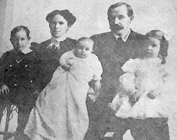
Herbert Raymond in May 1922 ― see S Raymond Street for the Seattle Times article this photo was taken from
Born and raised in Seattle, Benjamin Donguk Lukoff had his interest in local history kindled at the age of six, when his father bought him settler granddaughter Sophie Frye Bass’s Pig-Tail Days in Old Seattle at the gift shop of the Museum of History and Industry. He studied English, Russian, and linguistics at the University of Washington, and went on to earn his master’s in English linguistics from University College London. His book of rephotography, Seattle Then and Now, was published in 2010. An updated version came out in 2015.
This street was named in 1906 as Raymond Avenue, part of Replat Tracts 30 & 31 Sunnyside 5 Acre Tracts, by Herbert R. Raymond (1862–1933) of New Brunswick, Canada, and his wife, Minnie M. Raymond (1874–1947), née Truax, of Massachusetts. In 1907, it and Spencer Avenue became Raymond Street as part of the renaming of streets in Beacon Hill and Rainier Valley, and Grand Avenue, Grand View Avenue, and Sixteenth Street in West Seattle took the name as well. Three years later, when Georgetown was annexed, Raymond Street replaced James Street. (All this information from Rob Ketcherside’s extremely useful searchable table of street name changes.)
Herbert came to Washington as a child, along with his family; Minnie appears to have come later, and the two married in 1895. His eldest brother, George (Herbert was the youngest of eight children), sold shoes in Seattle and was also on the city council and in the territorial, as it then was, legislature. He later moved to Bellingham and was on the city council there in 1912 and 1913, and was mayor for less than two months, in December 1915 and January 1916, his term ending with his sudden death.
Herbert himself was also in the shoe business. As his Seattle Times obituary put it, he was:
Formerly one of the Pacific Northwest’s prominent shoe merchants and leading civic spirits… He had been retired for the past twelve years and had spent most of his time out of doors improving his two-acre residential property which overlooks Lake Washington. Mr. Raymond came to Seattle four years before the Seattle fire and helped fight it. His first shoe store was at First Avenue near Madison Street. He operated in other locations and under other firm names in subsequent years.
Article in the May 7, 1922, Seattle Times, about deer grazing on Herbert Raymond’s lawn and in his orchard. “I believe they came originally from Mercer Island, swimming across to Seward Park. There are no dogs about and the tempting green stuff in my garden coaxed them over the fence…. I don’t see a chance to grow a garden. But the deer are worth it. Their beauty more than repays for their feed.” Download the article as a PDF.
S Raymond Street begins at 51st Place S and goes just over ⅕ of a mile west to 48th Avenue S. It resumes at 44th Avenue S and goes a block west to 42nd Avenue S. There is another short segment that goes 1½ blocks west from Martin Luther King Jr. Way S, and then a longer segment begins at 33rd Avenue S and goes ½ a mile west to Beacon Avenue S, the portion crossing the Chief Sealth Trail being a pathway. A few more segments appear between 24th Avenue S and Swift Avenue S.
SW Raymond Street begins in West Seattle at High Point Drive SW and SW Graham Street and goes 1¼ miles west to 49th Avenue SW.
Born and raised in Seattle, Benjamin Donguk Lukoff had his interest in local history kindled at the age of six, when his father bought him settler granddaughter Sophie Frye Bass’s Pig-Tail Days in Old Seattle at the gift shop of the Museum of History and Industry. He studied English, Russian, and linguistics at the University of Washington, and went on to earn his master’s in English linguistics from University College London. His book of rephotography, Seattle Then and Now, was published in 2010. An updated version came out in 2015.
This street received its name in 1907, uniting streets formerly known as Nebraska Street, 8th Street, Bedford Street, Conover Street, and G Street. (There had been an Oregon Street in the 1895 Seattle Tide Lands plat in which Nebraska Street was created, but it became Spokane Street and Chelan Avenue in the same 1907 change.)
S Oregon Street begins in West Seattle as SW Oregon Street at the Emma Schmitz Memorial Overlook on Beach Drive SW and goes two blocks east to Me-Kwa-Mooks Park at 56th Avenue SW. It briefly resumes at 52nd Avenue SW and goes two blocks east to 51st Avenue SW, then begins again in earnest at 50th Avenue SW, going nearly a mile east to the West Seattle Stadium at 35th Avenue SW, part of the stretch between there and Fauntleroy Way SW being footpath and stairway. East of the West Seattle Golf Course, it goes around 175 feet to 26th Avenue SW and the Delridge Playfield, and on the other side of the playfield serves as a short connector between Delridge Way SW and 23rd Avenue SW.
S Oregon Street resumes east of the Duwamish Waterway at a shoreline street end and goes ¼ mile east to E Marginal Way S. It then serves as short connectors between Diagonal Avenue S and Denver Avenue S and between 7th Avenue S and Airport Way S.
East of Interstate 5, on Beacon Hill, S Oregon Street begins again at 10th Avenue S and goes ⅓ of a mile east to 15th Avenue S and S Columbian Way. It picks up again in the Rainier Valley at S Columbian Way and Martin Luther King Jr. Way S and goes ⅔ of a mile east to Genesee Park at 42nd Avenue S. East of the park, it resumes at 47th Avenue S and goes ¼ mile east to its end at 52nd Avenue S above the Lakewood Marina on Lake Washington.
Born and raised in Seattle, Benjamin Donguk Lukoff had his interest in local history kindled at the age of six, when his father bought him settler granddaughter Sophie Frye Bass’s Pig-Tail Days in Old Seattle at the gift shop of the Museum of History and Industry. He studied English, Russian, and linguistics at the University of Washington, and went on to earn his master’s in English linguistics from University College London. His book of rephotography, Seattle Then and Now, was published in 2010. An updated version came out in 2015.
Streets in this plat that were not extensions of already existing ones, such as Commercial Street, were named after letters of the alphabet, American cities, American states, prominent local politicians, and places in Washington.… the states appear neither in alphabetical nor geographic order.
In this case, of course, the street was named for the Dakotas, not for South Dakota.
SW Dakota Street begins at 56th Avenue SW and goes 1⅓ miles east to 34th Avenue SW. It resumes at 30th Avenue SW and goes a further ⅓ of a mile east to Delridge Way SW, the portion between 28th Avenue SW and 26th Avenue SW being footpaths through the Longfellow Creek Natural Area park. SW Dakota Street begins again just west of 21st Avenue SW and goes just over 750 feet east to 19th Avenue SW, and there is one final segment west of the Duwamish Waterway between 16th Avenue SW and W Marginal Way SW.
East of the Duwamish, S Dakota Street runs for a block between 1st Avenue S and 2nd Avenue S, then picks up again at 6th Avenue S and goes ¼ mile east to 9th Avenue S. East of Interstate 5 on Beacon Hill, S Dakota Street resumes at 12th Avenue S and goes another ¼ mile east to Jefferson Park at 16th Avenue S. It begins again in the Rainier Valley at 29th Avenue S and goes ⅓ of a mile east to 34th Avenue S, picking up again at Rainier Avenue S and going ⅖ of a mile east to Genesee Park at 43rd Avenue S. On the other side of the park, it resumes at 46th Avenue S and goes ⅓ of a mile east to its end at 51st Avenue S, overlooking Lake Washington.
Born and raised in Seattle, Benjamin Donguk Lukoff had his interest in local history kindled at the age of six, when his father bought him settler granddaughter Sophie Frye Bass’s Pig-Tail Days in Old Seattle at the gift shop of the Museum of History and Industry. He studied English, Russian, and linguistics at the University of Washington, and went on to earn his master’s in English linguistics from University College London. His book of rephotography, Seattle Then and Now, was published in 2010. An updated version came out in 2015.
Like its neighbors S Hudson Street and S Americus Street, S Ferdinand Street was created in 1891 as part of the plat of Columbia. (The town incorporated in 1893 and was annexed to Seattle in 1907, becoming the neighborhood of Columbia City.) Along with Columbus Street, which no longer exists, they were part a of series of streets named after explorers — in this case, Ferdinand Magellan (born Fernão de Magalhães, also known as Fernando de Magallanes) (1480–1521), the first explorer to sail from Europe to Asia via the Atlantic and Pacific Oceans.
S Ferdinand Street begins at Lake Washington Boulevard S and goes a block west to just past 55th Avenue S. It is a stairway between 54th Avenue S and 53rd Avenue S, then begins again at 52nd Avenue S. After a half block as roadway and another half block as stairway, it begins in earnest at 51st Avenue S by Lakewood Park and goes just over a mile west to 31st Avenue S. It is another stairway for the next block, and then a stub off 30th Avenue S.
On Beacon Hill, S Ferdinand Street begins again at 28th Avenue S and goes ½ a mile west to 20th Avenue S, then resumes at 19th Avenue S and goes a further ⅖ to 13th Avenue S. It finishes up as a short connector from 12th Avenue S to Corson Avenue S by Maple Wood Playfield.
Born and raised in Seattle, Benjamin Donguk Lukoff had his interest in local history kindled at the age of six, when his father bought him settler granddaughter Sophie Frye Bass’s Pig-Tail Days in Old Seattle at the gift shop of the Museum of History and Industry. He studied English, Russian, and linguistics at the University of Washington, and went on to earn his master’s in English linguistics from University College London. His book of rephotography, Seattle Then and Now, was published in 2010. An updated version came out in 2015.
This road is named after Seward Park, which occupies all of Bailey Peninsula’s 300 acres, as envisioned by the Olmsted Brothers. The park itself was bought by the city in 1911 and named after William Henry Seward (1801–1872), who was governor of New York from 1839–1842, senator from New York from 1849–1861, and secretary of state under Abraham Lincoln and Andrew Johnson from 1861–1869. His negotiation of the purchase of Alaska from Russia in 1867 proved to be a major boon for Seattle, which nearly doubled its population between 1890 and 1900 due in no small part to the Klondike Gold Rush, and remains a gateway to Alaska to this day.
Seward Park Road begins at Lake Washington Boulevard S and S Juneau Street and winds for ⅓ of a mile into the park’s interior, where it becomes a ¾-mile-long loop. (It should not be confused with Shore Loop Road, which runs along the park’s perimeter on the Lake Washington shoreline and is not open to vehicle traffic. Like all park roads in Seattle, Seward Park Road carries no directional designation)
Article in The Seattle Times on the naming of Seward Park, June 11, 1911. William Elder Bailey paid $26,000 to buy Bailey Peninsula in 1889 and the city began to consider it a potential park shortly thereafter. (It had previously been known as Graham Peninsula, after early settler David Graham, and Andrews Peninsula [though no one is sure who this Andrews might have been].) Bailey made it difficult for the city, finally offering to sell it for $430,000 in 1908, but the city ended up acquiring it for a more reasonable $322,000 in early 1911. Read more at HistoryLink.org and Friends of Seward Park.
Aerial view of Seward Park from the south, circa 1965–1966. The Martha Washington School for Girls, (closed 1971, now Martha Washington Park) is in the foreground. Mercer Island and Lake Washington are in the background. Courtesy of the Seattle Municipal Archives, Identifier 192974.
Born and raised in Seattle, Benjamin Donguk Lukoff had his interest in local history kindled at the age of six, when his father bought him settler granddaughter Sophie Frye Bass’s Pig-Tail Days in Old Seattle at the gift shop of the Museum of History and Industry. He studied English, Russian, and linguistics at the University of Washington, and went on to earn his master’s in English linguistics from University College London. His book of rephotography, Seattle Then and Now, was published in 2010. An updated version came out in 2015.
S Kenny Street begins on Beacon Hill at 21st Avenue S and goes two blocks east to 23rd Avenue S. It resumes in Hillman City at 42nd Avenue S and goes ¼ mile east to a dead end east of Rainier Avenue S. Its final segment, just under 400 feet long, lies west of 51st Avenue S and dead-ends at some private driveways.
Bessie and C.D. Hillman and family, from a 1910 abstract of title for C.D. Hillman’s Birmingham Water Front Addition to the City of Everett
Born and raised in Seattle, Benjamin Donguk Lukoff had his interest in local history kindled at the age of six, when his father bought him settler granddaughter Sophie Frye Bass’s Pig-Tail Days in Old Seattle at the gift shop of the Museum of History and Industry. He studied English, Russian, and linguistics at the University of Washington, and went on to earn his master’s in English linguistics from University College London. His book of rephotography, Seattle Then and Now, was published in 2010. An updated version came out in 2015.
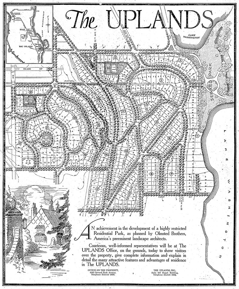
This street, created in 1926 as part of the plat of The Uplands (S Upland Road), was so named because it runs along the Lake Washington shoreline just south of Seward Park.
Full-page ad for The Uplands in The Seattle Times, September 27, 1925. Lake Shore Drive is at the lower right-hand corner of the plat.
Lake Shore Drive S begins at Seward Park Avenue S and S Hawthorn Road and goes ¼ mile south to S Eddy Street.
Born and raised in Seattle, Benjamin Donguk Lukoff had his interest in local history kindled at the age of six, when his father bought him settler granddaughter Sophie Frye Bass’s Pig-Tail Days in Old Seattle at the gift shop of the Museum of History and Industry. He studied English, Russian, and linguistics at the University of Washington, and went on to earn his master’s in English linguistics from University College London. His book of rephotography, Seattle Then and Now, was published in 2010. An updated version came out in 2015.
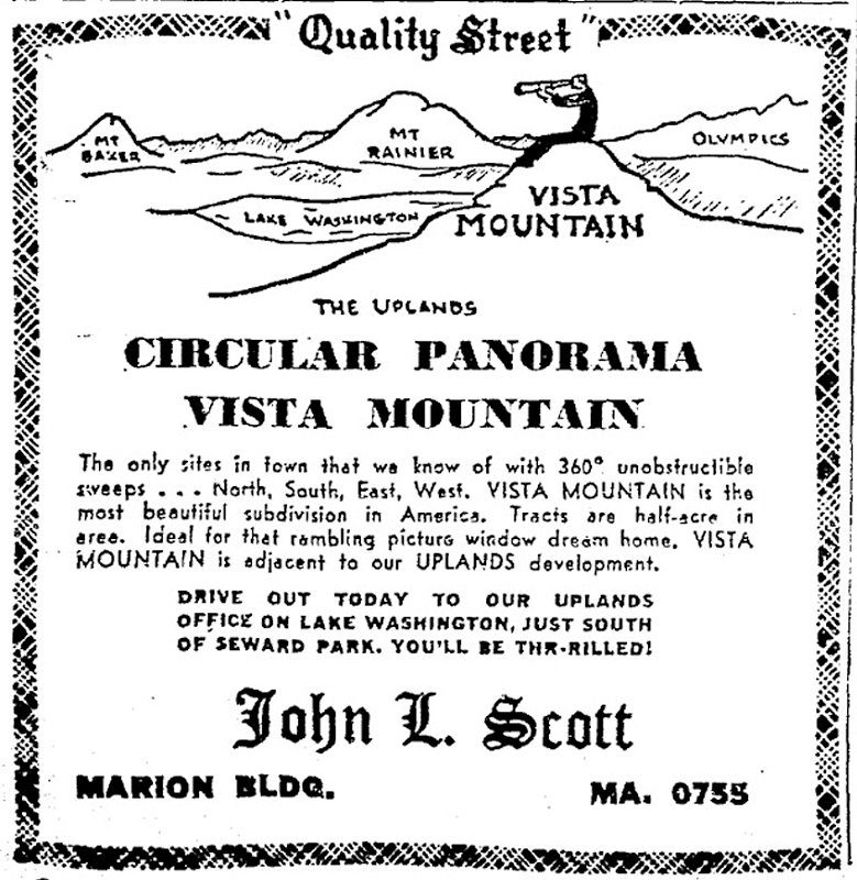
This street, like S Upland Road, was created in 1926 as part of the plat of The Uplands, so named for its location on a hill overlooking Seward Park. This portion of the neighborhood, however, wasn’t developed until the early 1950s, after having been replatted in 1949 as Vista Mountain.
Ad for the Vista Mountain subdivision, The Seattle Times, February 12, 1950
Upland Terrace S begins at 52nd Avenue S just north of S Graham Street and goes around 1,500 feet north to 51st Place S at S Juneau Street.
Born and raised in Seattle, Benjamin Donguk Lukoff had his interest in local history kindled at the age of six, when his father bought him settler granddaughter Sophie Frye Bass’s Pig-Tail Days in Old Seattle at the gift shop of the Museum of History and Industry. He studied English, Russian, and linguistics at the University of Washington, and went on to earn his master’s in English linguistics from University College London. His book of rephotography, Seattle Then and Now, was published in 2010. An updated version came out in 2015.
This street was created in 1926 as part of the plat of The Uplands, so named for its location on a hill overlooking Seward Park. Designed by the Olmsted Brothers firm, it was advertised as “a highly restricted residential park” (see below, The Seattle Times, September 27, 1925). A separate advertisement that ran on September 30 of the same year spoke of the “protective restrictions by which the home sites are safeguarded,” and another one on October 9 described The Uplands as “a residential district so carefully planned and highly restricted the home owner may look into the future with full knowledge and assurance that his property will, for all time, be safeguarded and protected.”
Full-page ad for The Uplands in The Seattle Times, September 27, 1925
Neither the Friends of Seattle’s Olmsted Parks nor the Seattle Civil Rights and Labor History Project have found any evidence of racial restrictive covenants for The Uplands, though it’s marked in the latter’s database as “restrictions were advertised in newspapers and enforced by realtors, but deed records have not yet been found in partial search.” As the Friends of Seattle’s Olmsted Parks’ history of Seward Park notes,
…In 1960 a group of white neighbors, led by realtor John L. Scott, tried to prevent an African American physician and his family from moving in. The Civic Unity Committee (CUC) documented what happened. Dr. J.R. Henry ultimately moved his family in without disturbance that December, though Scott delivered a parting message saying Henry was “no gentleman” for refusing Scott’s offer (to buy him out).
You can learn more about the Henrys’ story in this article by KUOW’s Isolde Raftery.
Today, S Upload Road begins at Wilson Avenue S and goes 1,000 feet northeast to S Hawthorn Road.
Born and raised in Seattle, Benjamin Donguk Lukoff had his interest in local history kindled at the age of six, when his father bought him settler granddaughter Sophie Frye Bass’s Pig-Tail Days in Old Seattle at the gift shop of the Museum of History and Industry. He studied English, Russian, and linguistics at the University of Washington, and went on to earn his master’s in English linguistics from University College London. His book of rephotography, Seattle Then and Now, was published in 2010. An updated version came out in 2015.
This street was named for Walter Graham (1828–1919), who came to Seattle in 1853. Three years later, he married Eliza Mercer, second daughter of Thomas Mercer (Mercer Street, Mercer Island), though she unfortunately died six years later. With his third wife, Elizabeth Crammond (or Crommon), he had a daughter, Nellie, who later married David Thomas Denny II, son of early settler David Thomas Denny (Denny Way). Graham’s brother, David, came to Seattle four years after his brother, and was one of the city’s first schoolteachers. He ended up marrying Eliza Mercer’s sister, Susannah.
Graham sold some of his southeast Seattle land in 1865 to Everett Smith, who filed the plat of Brighton Beach in 1890 on which what was then Graham Avenue appeared. He once owned what is today Seward Park on Bailey Peninsula, which was previously known as Graham’s Peninsula.
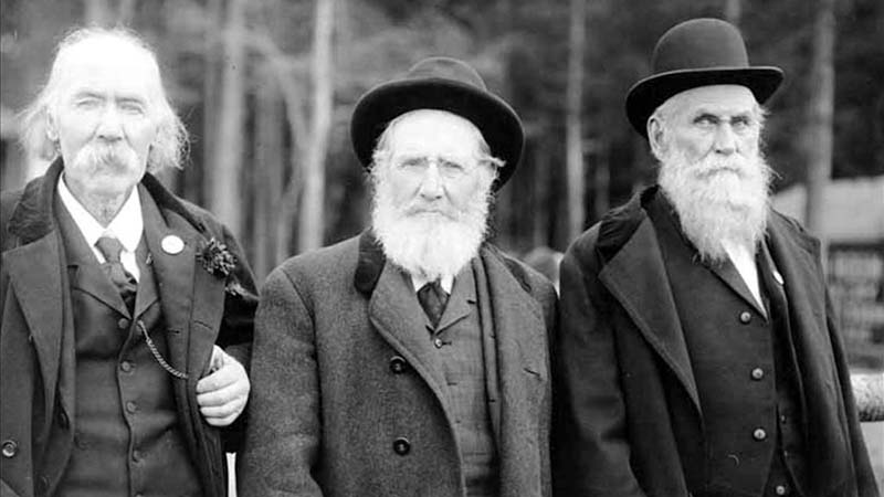
He was present at the Battle of Seattle in 1856, and is pictured below with fellow survivors Ira Woodin and Carson D. Boren (Boren Avenue).
Ira Woodin, Carson Boren, and Walter Graham at Alki Point, November 3, 1905
S Graham Street begins in the east at Wilson Avenue S and goes 2⅒ miles west to Swift Avenue S and 20th Avenue S, just east of Interstate 5. After a short segment between Corgiat Drive S and 16th Avenue S just west of the freeway, it next appears in West Seattle. Betwen 16th Avenue SW and 22nd Avenue SW, it alternates between roadway, stairway, and pathway, and there is a similar situation between 25th Avenue SW at Delridge Way SW and High Point Drive SW at Bataan Park. SW Graham Street begins again at High Point Drive SW and SW Raymond Street and goes 1¼ miles to its end at 50th Avenue SW,
Born and raised in Seattle, Benjamin Donguk Lukoff had his interest in local history kindled at the age of six, when his father bought him settler granddaughter Sophie Frye Bass’s Pig-Tail Days in Old Seattle at the gift shop of the Museum of History and Industry. He studied English, Russian, and linguistics at the University of Washington, and went on to earn his master’s in English linguistics from University College London. His book of rephotography, Seattle Then and Now, was published in 2010. An updated version came out in 2015.
This street, which is nowhere longer than a couple of blocks long, begins at 54th Avenue S in the east, just west of Andrews Bay and Seward Park, and finishes up at Corson Avenue S in the west, just east of Interstate 5.
According to Lucile Saunders McDonald, writing in The Seattle Times on January 1, 1956, it is named for Pearl Josephine Hulbert Faurote (1883–1981), granddaughter of Joseph and Catherine (Henderson) Dunlap (of S Henderson Street). I listed her as the street’s namesake when I originally posted this article. However, S Pearl Street is quite a bit north of Dunlap’s Plat of Land on Lake Washington — about 2¼ miles from Henderson. The name appears to have originated in Hillman City Division № 8, filed in 1903. As of May 19, 2021, neither I nor Valarie Bunn nor Rob Ketcherside nor Matt McCauley — who first called my attention to the fact that McDonald’s assertion was unsourced — have been able to find a connection between the Hillmans and anyone named Pearl. Nor does there appear to be any particular connection between the Hillmans and the Dunlaps or Hulberts, other than their all being active in Seattle real estate.
It seems, then, that the origin of Pearl Street should be regarded as an open question.
Born and raised in Seattle, Benjamin Donguk Lukoff had his interest in local history kindled at the age of six, when his father bought him settler granddaughter Sophie Frye Bass’s Pig-Tail Days in Old Seattle at the gift shop of the Museum of History and Industry. He studied English, Russian, and linguistics at the University of Washington, and went on to earn his master’s in English linguistics from University College London. His book of rephotography, Seattle Then and Now, was published in 2010. An updated version came out in 2015.
This street lies mostly in Columbia City, where its name originated, and Seward Park, with a few blocks in Beacon Hill and even fewer in West Seattle. It almost reaches Puget Sound at Beach Drive SW, and does reach Andrews Bay of Lake Washington at Lake Washington Boulevard S.
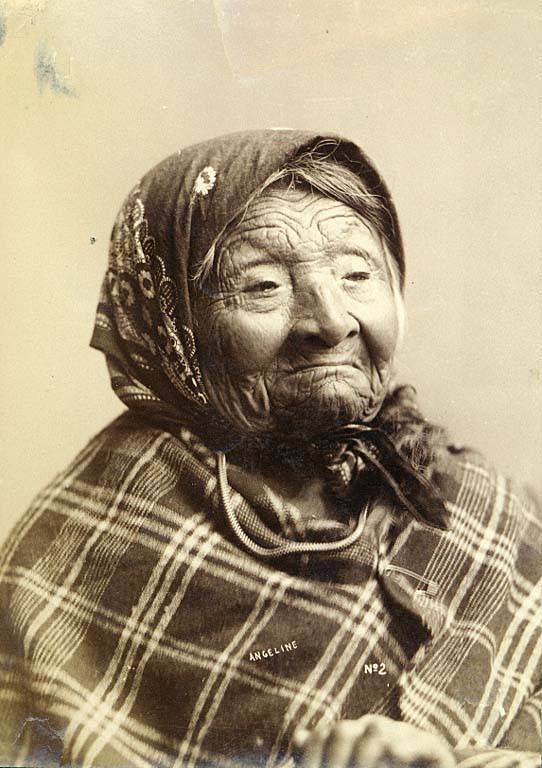
Princess Angeline was born Kikisoblu, the daughter of Si’ahl [siʔaɫ], better known in English as Chief Seattle of the Duwamish and Suquamish Tribes. Her date of birth is unknown; Wikipedia gives it as ca. 1820, whereas this article posted by the Duwamish Tribe, written by elementary school students based on HistoryLink essays, gives it as 1828. She died May 31, 1896.
Princess Angeline received her English name from Catherine Broshears Maynard, wife of David Swinson (“Doc”) Maynard, one of the earliest Seattle settlers. As the HistoryLink Elementary article puts it,
Chief Seattle’s oldest daughter was named Kikisoblu. She became friends with many of Seattle’s founding families. One of her friends was Catherine Maynard. She felt that Kikisoblu should have a name that would let the white settlers know that she was the daughter of a great chief. So she called her Princess Angeline. She thought that name was prettier than the name Kikisoblu.
Photograph of Princess Angeline (Kikisoblu), by Frank La Roche, ca. 1893
Born and raised in Seattle, Benjamin Donguk Lukoff had his interest in local history kindled at the age of six, when his father bought him settler granddaughter Sophie Frye Bass’s Pig-Tail Days in Old Seattle at the gift shop of the Museum of History and Industry. He studied English, Russian, and linguistics at the University of Washington, and went on to earn his master’s in English linguistics from University College London. His book of rephotography, Seattle Then and Now, was published in 2010. An updated version came out in 2015.


