Portion of River Park addition showing Southern Avenue (now Southern Street)
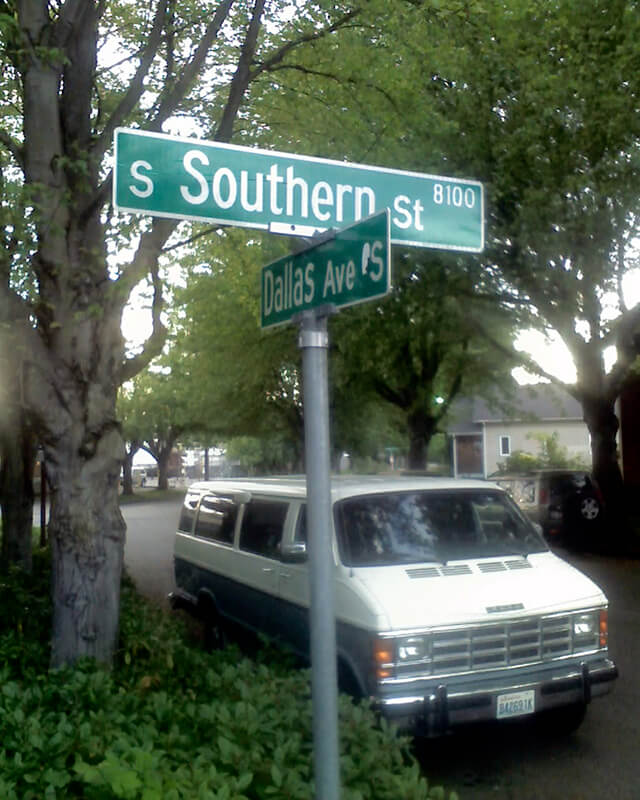
S Southern Street begins just east of 12th Avenue S on the west bank of the Duwamish Waterway, and goes ½ a mile to just west of 7th Avenue S, where it is blocked by Washington State Route 99 (W Marginal Way S). (Its first tenth of a mile is within unincorporated King County as part of the “Sliver by the River.”) It begins again in West Seattle as SW Southern Street at 35th Avenue SW, and goes ⅗ of a mile to 44th Avenue SW.
Born and raised in Seattle, Benjamin Donguk Lukoff had his interest in local history kindled at the age of six, when his father bought him settler granddaughter Sophie Frye Bass’s Pig-Tail Days in Old Seattle at the gift shop of the Museum of History and Industry. He studied English, Russian, and linguistics at the University of Washington, and went on to earn his master’s in English linguistics from University College London. His book of rephotography, Seattle Then and Now, was published in 2010. An updated version came out in 2015.
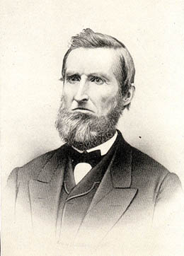
Martin Van Buren Stacy, from his obituary in the April 18, 1901, Seattle Post-Intelligencer. He had died at Green River Hot Springs the previous week of “apoplexy.”
S Stacy Street begins at Airport Way S and goes ⅕ of a mile west to 6th Avenue S. There is a block-long segment between 4th Avenue S and 3rd Avenue S, and then on the other side of the former Stacy Yard a two-block–long segment from Occidental Avenue S to Utah Avenue S and the world headquarters of Starbucks.
Born and raised in Seattle, Benjamin Donguk Lukoff had his interest in local history kindled at the age of six, when his father bought him settler granddaughter Sophie Frye Bass’s Pig-Tail Days in Old Seattle at the gift shop of the Museum of History and Industry. He studied English, Russian, and linguistics at the University of Washington, and went on to earn his master’s in English linguistics from University College London. His book of rephotography, Seattle Then and Now, was published in 2010. An updated version came out in 2015.
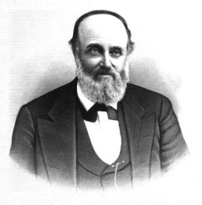
This street was named for Walter Graham (1828–1919), who came to Seattle in 1853. Three years later, he married Eliza Mercer, second daughter of Thomas Mercer (Mercer Street, Mercer Island), though she unfortunately died six years later. With his third wife, Elizabeth Crammond (or Crommon), he had a daughter, Nellie, who later married David Thomas Denny II, son of early settler David Thomas Denny (Denny Way). Graham’s brother, David, came to Seattle four years after his brother, and was one of the city’s first schoolteachers. He ended up marrying Eliza Mercer’s sister, Susannah.
Graham sold some of his southeast Seattle land in 1865 to Everett Smith, who filed the plat of Brighton Beach in 1890 on which what was then Graham Avenue appeared. He once owned what is today Seward Park on Bailey Peninsula, which was previously known as Graham’s Peninsula.
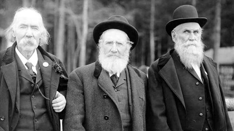
He was present at the Battle of Seattle in 1856, and is pictured below with fellow survivors Ira Woodin and Carson D. Boren (Boren Avenue).
Ira Woodin, Carson Boren, and Walter Graham at Alki Point, November 3, 1905
S Graham Street begins in the east at Wilson Avenue S and goes 2⅒ miles west to Swift Avenue S and 20th Avenue S, just east of Interstate 5. After a short segment between Corgiat Drive S and 16th Avenue S just west of the freeway, it next appears in West Seattle. Betwen 16th Avenue SW and 22nd Avenue SW, it alternates between roadway, stairway, and pathway, and there is a similar situation between 25th Avenue SW at Delridge Way SW and High Point Drive SW at Bataan Park. SW Graham Street begins again at High Point Drive SW and SW Raymond Street and goes 1¼ miles to its end at 50th Avenue SW,
Born and raised in Seattle, Benjamin Donguk Lukoff had his interest in local history kindled at the age of six, when his father bought him settler granddaughter Sophie Frye Bass’s Pig-Tail Days in Old Seattle at the gift shop of the Museum of History and Industry. He studied English, Russian, and linguistics at the University of Washington, and went on to earn his master’s in English linguistics from University College London. His book of rephotography, Seattle Then and Now, was published in 2010. An updated version came out in 2015.
Howell was captain of the SS Pacific, en route from Victoria to San Francisco, when it sank off Cape Flattery the evening of November 4, 1875. Only one passenger and one crew member survived of nearly 275 aboard, making it the worst maritime disaster on the West Coast to date. As Daryl C. McClary writes for HistoryLink.org:
Although lost at sea, Jefferson Davis Howell was not forgotten by his many friends in Puget Sound. They had a 10-foot-tall sandstone obelisk erected in his memory at the Seattle Masonic Cemetery, established in 1872 and renamed the Lake View Cemetery in 1890. On the base of the monument is chiseled the simple epitaph: “Captain J. D. Howell, perished at sea on the steamship Pacific, November 4, 1875, aged 34 years.”
Howell Street begins at 8th Avenue and Olive Way and goes ⅓ of a mile northwest to Eastlake Avenue, just west of Interstate 5. On the other side of the freeway, it resumes at Bellevue Avenue as E Howell Street and goes ⅕ of a mile east to Harvard Avenue, where it is blocked by Seattle Central College. After a very short segment between Broadway and Nagle Place, it begins again east of Cal Anderson Park at 11th Avenue and goes ½ a mile east to 19th Avenue. E Howell Street resumes at Homer Harris Park at 24th Avenue and goes ¾ of a mile east to 38th Avenue, being a stairway and pathway between the alley east of 25th Avenue and 26th Avenue. It begins again at Madrona Drive and goes ⅒ of a mile east to 39th Avenue E and Evergreen Place. Its last segment is just over 100 feet long, from Lake Washington Boulevard to Howell Place and Howell Park beach.
Born and raised in Seattle, Benjamin Donguk Lukoff had his interest in local history kindled at the age of six, when his father bought him settler granddaughter Sophie Frye Bass’s Pig-Tail Days in Old Seattle at the gift shop of the Museum of History and Industry. He studied English, Russian, and linguistics at the University of Washington, and went on to earn his master’s in English linguistics from University College London. His book of rephotography, Seattle Then and Now, was published in 2010. An updated version came out in 2015.
I have read that, and until recently assumed that, S Horton Street is named for Dexter Horton (1825–1904), but have come to wonder if it instead is named for Julius, his younger brother (1834–1904), or for the Horton family in general. Julius came to Seattle in 1869, bought land in South Seattle in 1871, and platted Georgetown in 1890, naming it after his son, George (1865–1927), who had recently become a doctor. (Georgetown became a city in 1904 and was annexed by Seattle in 1910.) S Horton Street doesn’t run through Georgetown — it’s around 2 miles north of there — but it does run through South Seattle. It appears to have been named in 1870, after Julius arrived in town but before he bought what is now Georgetown. I am not sure if Dexter had any special connection to South Seattle; he certainly never lived there.
Julius Horton and family, circa 1890. Back row, left to right: Dora Estelle (Horton) Carle, Mabel Maude (Horton) Edlund, Flora Groover, Elmer Petigoe. Front row, left to right: May Bigelow Boucher, Julius Horton, Howard Dexter Horton, Anna Emily (Bigelow) Horton, Vera Horton Hudson, George Monroe Horton, and Harry Bateman.
S Horton Street begins at E Marginal Way S and goes ⅔ of a mile east to 6th Avenue S, with a brief interruption at the SODO Busway. After a block-long segment between Airport Way S and 10th Avenue S just west of Interstate 5, it resumes on Beacon Hill at 13th Avenue S, where it goes one block east. It begins again at 16th Avenue S and goes ⅖ of a mile to 23rd Avenue S, being a stairway and pathway from just east of 19th Avenue S to 20th Avenue S. Horton resumes east of Kimball Elementary School at 24th Avenue S and goes a block and a half before it ends at the Cheasty Natural Area. Besides a very short segment just west of Martin Luther King Jr. Way S, its next appearance is at 33rd Avenue S and S Walden Street. From here, it goes ½ a mile east to Lake Washington Boulevard S, being a stairway between 36th Avenue S and 37th Place S and a stairway and pathway between Cascadia Avenue S and Sierra Drive S. Between Sierra Drive S and Lake Washington Boulevard S, it is part of Landing Parkway, under the jurisdiction of the parks department.
Born and raised in Seattle, Benjamin Donguk Lukoff had his interest in local history kindled at the age of six, when his father bought him settler granddaughter Sophie Frye Bass’s Pig-Tail Days in Old Seattle at the gift shop of the Museum of History and Industry. He studied English, Russian, and linguistics at the University of Washington, and went on to earn his master’s in English linguistics from University College London. His book of rephotography, Seattle Then and Now, was published in 2010. An updated version came out in 2015.
I initially posted that this street was named for Judge Edward Lander (1816–1907), chief justice of the territorial supreme court from 1853 to 1857. In 1855, he, along with Charles Terry, bought Carson Boren’s downtown land claim for $500. They subsequently donated two acres of land, along with Arthur Denny, who donated eight, to form the first campus of the University of Washington, which opened in 1861. The university owns the Metropolitan Tract to this day, though it moved to its present location in 1895. Lander’s name also appears on Lander Hall, a UW dormitory on NE Campus Parkway.
Edward Lander was a political foe of and was jailed by Stevens [then governor of Washington Territory] when Lander opposed Stevens’ 1855 martial law declaration and actions. Stevens and Edward Lander maintained a widely recognized lifelong enmity. It is unlikely that Hanford would have memorialized this hostility.
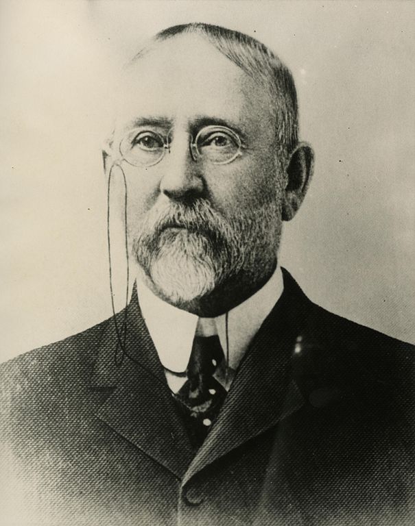
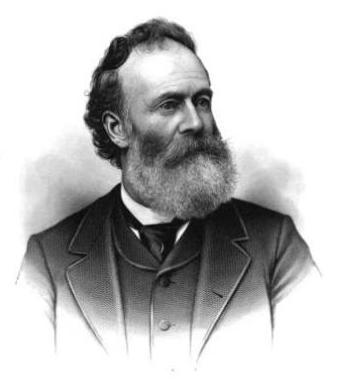
Frederick W. Lander
SW Lander Street begins at 59th Avenue SW in the Alki neighborhood of West Seattle, and goes ⅕ of a mile to 55th Avenue SW. It resumes just to the south at S Lander Place and goes a further ⅛ of a mile to SW Admiral Way. Picking up again at 50th Avenue SW, it makes it ½ a mile to Walnut Avenue SW before being interrupted again, as happens to so many West Seattle streets because of the varying topography. There is a final ¼-mile stretch in West Seattle from 39th Avenue SW to 36th Avenue SW, then a very short segment on Harbor Island before S Lander Street resumes in the Industrial District at Colorado Avenue S and goes ¾ of a mile east to Airport Way S. On Beacon Hill, Lander begins just west of 13th Avenue S and goes ⅔ of a mile to just past 23rd Avenue S, including the block-long stretch that is now known as S Roberto Maestas Festival Street. Lander begins again at 30th Avenue S in Mount Baker and goes a final four blocks to 34th Avenue S.
Born and raised in Seattle, Benjamin Donguk Lukoff had his interest in local history kindled at the age of six, when his father bought him settler granddaughter Sophie Frye Bass’s Pig-Tail Days in Old Seattle at the gift shop of the Museum of History and Industry. He studied English, Russian, and linguistics at the University of Washington, and went on to earn his master’s in English linguistics from University College London. His book of rephotography, Seattle Then and Now, was published in 2010. An updated version came out in 2015.
This street is named for Edward Hanford (1807–1884) and his wife, Abigail Jane Holgate (1824–1905), who left Iowa in the early 1850s to settle adjacent to Abigail’s brother, John (namesake of S Holgate Street), on what is today known as Beacon Hill but was known from then until the early 1890s as Holgate and Hanford Hill. Edward and his family were loggers, then orchardists, and unlike John Holgate, he went on to develop his donation claim.
The Hanfords’ son Clarence (1857–1920) founded, with James D. Lowman, the Lowman & Hanford Stationery and Printing Company in 1885. The firm went out of business in the 1960s, but their Pioneer Square building still, the last time I drove by, had a sign painted on it reading “Seattle’s Oldest Retail Company,” which it very well might have been when it closed. Their son Thaddeus (1847–1892) was for a time the owner of the Daily Intelligencer newspaper, predecessor of the Seattle Post-Intelligencer. And their son Cornelius (1849–1926), a federal judge from 1890 to 1912, was earlier a territorial legislator, Seattle city attorney, and chief justice of the Washington Supreme Court. He is the namesake of Hanford, Washington, and by extension the Hanford Site, which produced the plutonium used in the first nuclear explosion and the bombing of Nagasaki. He was also the author of Seattle and Environs, 1852-1924.
Edward Hanford
SW Hanford Street begins in West Seattle at SW Admiral Way and 59th Avenue SW and goes ¼ mile east to Schmitz Preserve Park at 56th Avenue SW. It begins again at 51st Avenue SW and goes nearly a mile east to 36th Avenue SW, becoming a stairway for the half-block east of 46th Avenue SW. After serving as little more than a driveway between SW Admiral Way and Fauntleroy Avenue SW, it next appears as S Hanford Street at E Marginal Way S, where it goes for ⅓ of a mile east to Occidental Avenue S. After a few short segments farther east in the Industrial District, Hanford begins again on Beacon Hill at 12th Avenue S and goes nearly a mile east to Rainier Avenue S, the segment between 25th Avenue S and Morse Avenue S being a stairway. It resumes a few blocks east at 30th Avenue S and finishes up ½ a mile east at Cascadia Avenue S.
Born and raised in Seattle, Benjamin Donguk Lukoff had his interest in local history kindled at the age of six, when his father bought him settler granddaughter Sophie Frye Bass’s Pig-Tail Days in Old Seattle at the gift shop of the Museum of History and Industry. He studied English, Russian, and linguistics at the University of Washington, and went on to earn his master’s in English linguistics from University College London. His book of rephotography, Seattle Then and Now, was published in 2010. An updated version came out in 2015.
This street is named for John Cornelius Holgate (1828–1868). Born in Ohio, he took the Oregon Trail west in 1847 and explored Elliott Bay and the Duwamish River by canoe in the summer of 1850. (The Seattle Times calls him “the first non-Indian of record to have done so.”) He returned to Oregon afterwards, however, and did not settle in what is now Seattle — specifically, Beacon Hill — until 1853, two years after the Denny Party landed at Alki Point. His mother, Elizabeth; brothers, Lemuel and Milton; and sister, Abigail, along with her husband, Edward Hanford (namesakes of S Hanford Street), soon followed. The Hanfords settled on the hill — known thereafter as Holgate and Hanford Hill until the late 1880s — adjacent to Holgate. (Milton was one of three whites to die in the Battle of Seattle in 1856, and was himself the cause of one of those deaths, having earlier shot Jack Drew, a deserting sailor from the USS Decatur, in a “friendly-fire” incident.)
A gold prospector, Holgate left for Idaho in 1863, and died there in 1868, the first casualty of the War Under the Mountain, a conflict between two rival gold mines in the Owyhee Desert, one of which he was part owner. According to Robert L. Deen, writing for True West magazine, there are conflicting accounts of Holgate’s death. The Owyhee Avalanche reported that:
Desperate fighting ensued during the charge…. John C. Holgate… one of the foremost in the advance, was shot in the head, and must have died instantaneously.
The Idaho Tri-Weekly Statesman had a slightly different story:
It appears that J.C. Holgate has been killed, some say assassinated, murdered — not killed in a fight, but shot through the head without provocation.
SW Holgate Street begins in West Seattle just west of 47th Avenue SW and goes ¼ of a mile east to California Avenue SW at Palm Avenue SW. There are two more short segments on the peninsula, between 41st Avenue SW and Arch Avenue SW and between Victoria Avenue SW and Brook Avenue SW. S Holgate Street resumes at Utah Avenue S and goes ¾ of a mile east to an overpass over Interstate 5, where it becomes Beacon Avenue S. There is a one-block stretch between 12th Avenue S and 13th Avenue S on top of the hill, and then Holgate goes a mile from the Beacon Hill Playfield at 14th Avenue S to 31st Avenue S at Colman Park, the half-block east of 16th Avenue S being a stairway and the block between 28th Avenue S and 29th Avenue S being unimproved. There is finally a short stretch east of Lakeside Avenue S at 36th Avenue S that essentially serves as a private driveway; it is a shoreline street end, but one not yet accessible to the public.
Born and raised in Seattle, Benjamin Donguk Lukoff had his interest in local history kindled at the age of six, when his father bought him settler granddaughter Sophie Frye Bass’s Pig-Tail Days in Old Seattle at the gift shop of the Museum of History and Industry. He studied English, Russian, and linguistics at the University of Washington, and went on to earn his master’s in English linguistics from University College London. His book of rephotography, Seattle Then and Now, was published in 2010. An updated version came out in 2015.
“A street of good intentions but easily thwarted,” as Sophie Frye Bass puts it in Pig-Tail Days in Old Seattle, John Street is “named for two Johns,” she writes — “For John Denny [1793–1875], the father of Arthur and David, and John B. [1862–1913], the son of David.”
John Denny
John Bunyan Denny
Today, W John Street begins at Western Avenue W and goes ⅓ of a mile east to 2nd Avenue N and the Pacific Science Center campus. John Street resumes just east of the Space Needle at Broad Street and goes ½ a mile to Terry Avenue N. Picking up half a block to the east, it makes it a further ⅓ of a mile before being blocked by Interstate 5 at Stewart Street and Eastlake Avenue E. Resuming at Melrose Avenue E, it goes ⅙ of a mile to E Olive Way, which itself becomes E John Street a few blocks to the east at Broadway E. From there, it’s ⅓ of a mile to the Kaiser Permanente Capitol Hill Medical Center at 15th Avenue E. After beginning again at 16th Avenue E, E John makes it nearly a mile before being stopped by the Harrison Ridge Greenbelt at 32nd Avenue E. Its final stretch is ⅓ of a mile from the 33rd Avenue E right-of-way to 39th Avenue E at Viretta Park.
Born and raised in Seattle, Benjamin Donguk Lukoff had his interest in local history kindled at the age of six, when his father bought him settler granddaughter Sophie Frye Bass’s Pig-Tail Days in Old Seattle at the gift shop of the Museum of History and Industry. He studied English, Russian, and linguistics at the University of Washington, and went on to earn his master’s in English linguistics from University College London. His book of rephotography, Seattle Then and Now, was published in 2010. An updated version came out in 2015.
This street — named Pine Street in Terry’s Second Addition to the Town of Seattle, filed in 1872 — was renamed Terrace in 1876, presumably to avoid duplicating the Pine Street to the north. My assumption is it was given this name because of how steep First Hill is at this point — Paul Dorpat, writing for HistoryLink, says “Except at Terrace Street on the south and near Union Street on the north, the hill was readily negotiable first by hikers and later by street graders and trolley tracks.” One can see in the image below the long, steep stairway in the Terrace Street right-of-way “from 5th Avenue east to beyond 7th Avenue,” as Dorpat writes on his own blog.
Seattle Weights and Measures Division officials standing with confiscated scales in Terrace Street, 1917. Note long stairway in upper-right corner. Courtesy of the Seattle Municipal Archives, Identifier 1210.
Today, Terrace Street begins at Yesler Way above 4th Avenue and goes a block and a half up the hill before being blocked by Interstate 5. It resumes just east of Harborview Medical Center and goes ⅓ of a mile east to 12th Avenue. There is another short stretch of E Terrace Street from 20th Avenue to 23rd Avenue by Garfield High School, and then a final ½ mile from 30th Avenue to Lake Washington Boulevard in Leschi, the portion between 36th Avenue and Randolph Avenue being a stairway.
Born and raised in Seattle, Benjamin Donguk Lukoff had his interest in local history kindled at the age of six, when his father bought him settler granddaughter Sophie Frye Bass’s Pig-Tail Days in Old Seattle at the gift shop of the Museum of History and Industry. He studied English, Russian, and linguistics at the University of Washington, and went on to earn his master’s in English linguistics from University College London. His book of rephotography, Seattle Then and Now, was published in 2010. An updated version came out in 2015.
“Street” appears above in quotation marks because there is no W Semple Street — not a physical one, anyway, making Semple a paper street. It does, however, still exist as a public right-of-way, as do most of the other streets on the plat, whether or not they were built. (As anyone who has been to Magnolia knows, its tidelands — intended to become industrial land as part of the rejected Bogue Plan — were never filled in, with the late exception of the Elliott Bay Marina.) Three residences even have a W Semple Street address, though they are only accessible from a private roadway off 45th Avenue W.
As can be seen below in the North Magnolia section of the plat map, a great many blocks were created as part of the process. Most of the unfilled tidelands are owned by the city (many of them forming Magnolia Tidelands Park), but some of the lots remain to this day in private ownership. There have been attempts to build on them, but none recently, and I can’t imagine such a thing being permitted in the future. So W Semple Street is likely to remain one of the few unbuilt streets in this plat to have addresses, and W Cole Street, Puget Avenue W, West Point Avenue W, and their ilk will forever remain streets on paper only.
Born and raised in Seattle, Benjamin Donguk Lukoff had his interest in local history kindled at the age of six, when his father bought him settler granddaughter Sophie Frye Bass’s Pig-Tail Days in Old Seattle at the gift shop of the Museum of History and Industry. He studied English, Russian, and linguistics at the University of Washington, and went on to earn his master’s in English linguistics from University College London. His book of rephotography, Seattle Then and Now, was published in 2010. An updated version came out in 2015.
This street is named for Dr. Henry A. Smith (1830–1915), after whom Smith Cove is also named. He and his family once owned most of what is now Interbay, between Smith Cove and Salmon Bay. He is likely best known today for his translation of Chief Seattle’s Speech. Though its authenticity has been questioned, it is accepted by the Suquamish Tribe and Duwamish Tribe, both of which siʔaɫ was chief.
Dr. Henry A. Smith
Today, W Smith Street begins in Magnolia at the intersection of 37th Avenue W and 36th Avenue W and goes ⅘ of a mile east to just past 24th Avenue W, briefly becoming a stairway just west of 26th Avenue W at Ella Bailey Park. It begins again in Queen Anne at 7th Avenue W and goes ½ a mile east to Warren Avenue N, forming a portion of Queen Anne Boulevard between 1st Avenue W and Warren Avenue N. Smith Street’s final segment begins at 4th Avenue N and goes a block east, ending at a greenbelt overlooking Aurora Avenue N.
Born and raised in Seattle, Benjamin Donguk Lukoff had his interest in local history kindled at the age of six, when his father bought him settler granddaughter Sophie Frye Bass’s Pig-Tail Days in Old Seattle at the gift shop of the Museum of History and Industry. He studied English, Russian, and linguistics at the University of Washington, and went on to earn his master’s in English linguistics from University College London. His book of rephotography, Seattle Then and Now, was published in 2010. An updated version came out in 2015.
This street is named for Thomas Dickerson Mercer (1813–1898), who came to Seattle in 1853 and homesteaded 160 acres in what is now Lower Queen Anne, living at what is now Roy Street and Taylor Avenue N. He became a King County commissioner and probate judge, and named Lake Washington and Lake Union, whose Lushootseed names are x̌ačuʔ and xáx̌əʔčuʔ(‘lake’ and its diminutive, respectively). Mercer Island is named for him, as are three of its main streets, W Mercer Way, N Mercer Way, and E Mercer Way. Mercer Slough in Bellevue is named for his brother Aaron (1826-1902), and his brother Asa (1839–1917) is known for being the first instructor at, and first president of, the Territorial University of Washington (being the only college graduate in Seattle in 1861); and for bringing the “Mercer Girls” to Seattle to address the settlement’s severe gender imbalance (thereby inspiring the 1960s TV show Here Come the Brides).
Thomas Dickerson Mercer
Today, W Mercer Street begins at Elliott Avenue W and goes a block east to 6th Avenue W, where it becomes a stairway. At the top of the stairway, the street becomes a major arterial (connecting directly to Elliott via W Mercer Place) and goes 1⅔ miles east to Eastlake Avenue E and Lakeview Boulevard E, where it is blocked by Interstate 5. (It is, incidentally, laid out on the boundary between the donation land claims of Mercer and David Thomas Denny. Mercer’s claim is today bounded by Queen Anne Avenue N on the west, Lake Union on the east, Highland Drive on the north, and Mercer Street on the south.) Connecting Interbay, Lower Queen Anne, Seattle Center, State Route 99, South Lake Union, Interstate 5, and Capitol Hill, Mercer Street is a linchpin of Seattle’s transportation system — but not a beloved one, having earned the name “Mercer Mess” decades ago.
East of Interstate 5, E Mercer Street begins again at Melrose Avenue E and goes nearly 1½ miles to 28th Avenue E, interrupted only once, at 17th Avenue E, where it is pedestrian-only for half a block. Mercer resumes briefly at Dewey Place E but after a couple hundred feet becomes a stairway connecting to Lake Washington Boulevard E and 31st Avenue E. A block east of that, at 32nd Avenue E, E Mercer Street resumes as another stairway, and becomes a street again just west of 33rd Avenue E. This segment goes about ⅛ of a mile to 36th Avenue E. There is one final 200-foot-long segment of E Mercer Street east of 39th Avenue E. Platted into Lake Washington, this is a shoreline street end, but not, unfortunately, one open to the public. (It was this particular street end that first got me involved with Friends of Street Ends, as I grew up just ¼ of a mile up the hill.)
Born and raised in Seattle, Benjamin Donguk Lukoff had his interest in local history kindled at the age of six, when his father bought him settler granddaughter Sophie Frye Bass’s Pig-Tail Days in Old Seattle at the gift shop of the Museum of History and Industry. He studied English, Russian, and linguistics at the University of Washington, and went on to earn his master’s in English linguistics from University College London. His book of rephotography, Seattle Then and Now, was published in 2010. An updated version came out in 2015.
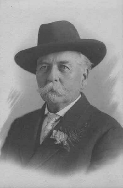
All in one year John McGraw was Chief of Police, Marshall, Sheriff, Harbor Master and Fire Warden. Later he was Governor of Washington and in between, bank president and attorney-at-law — quite a career.
The second governor of Washington after statehood (1893–1897), he had been King County sheriff during the anti-Chinese riots of 1886. He defended Chinese laborers from the mob that was trying to expel them from the city, although, according to The Role of Federal Military Forces in Domestic Disorders, 1877–1945, he initially sympathized with the rioters and allowed them to force the Chinese (without physically harming them) to the waterfront to be loaded onto the steamship Queen of the Pacific. Both he and Mayor Henry Yesler lost their bids for re-election that summer in what the book calls “a resounding show of support for anti-Chinese forces.”
John H. McGraw
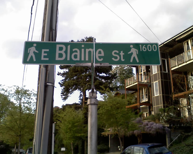
Today, W McGraw Street begins as a shoreline street end on Elliott Bay in Magnolia west of Perkins Lane W. It begins in earnest at the intersection of Westmont Way W, Montavista Place W, and Rosemont Place W and goes ⅘ of a mile east to 24th Avenue W, forming the heart of Magnolia Village, the neighborhood’s commercial district, from 35th Avenue W to 32nd Avenue W. It resumes on the other side of Interbay in Queen Anne, beginning at 11th Avenue W and going 1⅛ miles east to the Northeast Queen Anne Greenbelt east of Bigelow Avenue N. There are a few block-long segments heading down the hill to Westlake and, like Blaine Street, a right-of-way platted into Lake Union that serves as a driveway and affords no actual lake access.
E McGraw Street doesn’t appear again until 15th Avenue E and Boyer Avenue E in Montlake, where it goes ⅔ of a mile east to 26th Avenue E at the west end of the Washington Park Arboretum, becoming a stairway for a short distance just before 19th Avenue E. It ends for good in Madison Park as a two-block stretch between 38th Avenue E and 40th Avenue E.
Born and raised in Seattle, Benjamin Donguk Lukoff had his interest in local history kindled at the age of six, when his father bought him settler granddaughter Sophie Frye Bass’s Pig-Tail Days in Old Seattle at the gift shop of the Museum of History and Industry. He studied English, Russian, and linguistics at the University of Washington, and went on to earn his master’s in English linguistics from University College London. His book of rephotography, Seattle Then and Now, was published in 2010. An updated version came out in 2015.
Unfortunately, though the Blaines may have been feminists, they, according to HistoryLink.org, had no love for Native Americans (or, for that matter, the Irish). Their departure in 1856 was prompted by the Battle of Seattle. Junius Rochester writes:
On January 20, 1856, a son John, was born to Catharine and David Blaine. Six days later the Battle of Seattle erupted. David had duty at one of the blockhouses, but managed to get Catharine and their babe aboard the Decatur in Elliott Bay. David had described the Indians as a “poor degraded race,” which would “soon disappear.” Catharine compared their “stupidity and awkwardness” to that of the Irish. The Indian uprising confirmed their worst fears and prejudices.
Today, W Blaine Street begins in Magnolia at 36th Avenue W and goes a semicircular ⅕ of a mile to 34th Avenue W and W Howe Street. It resumes at 31st Avenue W and goes almost ⅓ of a mile to Thorndyke Avenue W. There is a stub of W Blaine east of 15th Avenue W that is quickly stopped by the Southwest Queen Anne Greenbelt. The street resumes at 12th Avenue W and goes just over a mile to 4th Avenue N, having briefly become a stairway at 9th Avenue W. After a series of short stretches serving as driveways and parking, the Blaine Street right-of-way resurfaces east of Westlake Avenue N and heads into Lake Union. Here, too, it serves as a driveway and offers no access to the water. East of Lake Union, E Blaine Street begins at Fairview Avenue E and goes ⅛ of a mile to Franklin Avenue E, where it becomes part of the I-5 Colonnade park underneath the freeway. From Lakeview Boulevard E to just west of 10th Avenue E it is a stairway, and then two blocks of roadway ending at 12th Avenue E and Lake View Cemetery. There is then a diagonal ¼-mile stretch from 19th Avenue E to E Howe Street in Montlake. E Blaine finishes up as a ⅕-mile stretch from 37th Avenue E to McGilvra Boulevard E and a final two-block run from E Madison Street to 43rd Avenue E, both in Madison Park.
Born and raised in Seattle, Benjamin Donguk Lukoff had his interest in local history kindled at the age of six, when his father bought him settler granddaughter Sophie Frye Bass’s Pig-Tail Days in Old Seattle at the gift shop of the Museum of History and Industry. He studied English, Russian, and linguistics at the University of Washington, and went on to earn his master’s in English linguistics from University College London. His book of rephotography, Seattle Then and Now, was published in 2010. An updated version came out in 2015.
Dillis Ward, when a young man, did his part in building the old University for he drove a team that hauled stone and lime for the foundation. After the building was finished, he entered as a pupil into the first class. He taught school later on, and many an old-timer can recall the genial, kindly school teacher.
According to this biography, Ward, who came to Seattle in 1859, also had a hand in founding both The Post (a predecessor of the Seattle Post-Intelligencer) and The Seattle Daily Chronicle (a predecessor of The Seattle Times). However, his name does not appear in Professor Edmond S. Meany’s Newspapers of Washington Territory, in this article on the Post Building from the Pacific Coast Architecture Database, or in this HistoryLink article on the history of the P-I. All of them do mention brothers Kirk C. and Mark Ward, but Dillis’s entry at FamilySearch mentions no siblings, and Mark and Kirk’s entries do not mention Dillis. However, they do appear to have the same father, Jesse Ward. It looks as if Dillis was Jesse’s son from his first marriage, to Elizabeth Raley. As she died the same year Dillis was born, it may have been in childbirth. Kirk and Mark appear to be Jesse’s sons from his subsequent marriage to Exeline Cason. Exactly what part he may have played in the founding of the papers, and why this is missing from the articles above (and, incidentally, from Pig-Tail Days, which one would think might have mentioned this fact) is unclear.
Ward Street begins at Queen Anne Avenue N and goes ⅗ of a mile east to Aurora Avenue N. There is a short segment of E Ward Street on Capitol Hill between 14th Avenue E and 15th Avenue E, followed by another one, ⅓ of a mile long, from 23rd Avenue E and Turner Way E down the hill to 29th Avenue E and E Aloha Street, at the west end of Washington Park Playfield. There follows another one-block segment on the other side of the park, between 31st Avenue E and 32nd Avenue E, and a final segment from 34th Avenue E to 37th Avenue E.
Born and raised in Seattle, Benjamin Donguk Lukoff had his interest in local history kindled at the age of six, when his father bought him settler granddaughter Sophie Frye Bass’s Pig-Tail Days in Old Seattle at the gift shop of the Museum of History and Industry. He studied English, Russian, and linguistics at the University of Washington, and went on to earn his master’s in English linguistics from University College London. His book of rephotography, Seattle Then and Now, was published in 2010. An updated version came out in 2015.
Today, W Republican Street begins a block west of 4th Avenue W and goes ⅖ of a mile east to Warren Avenue N, where it becomes Seattle Center’s pedestrian August Wilson Way. On the east side of Seattle Center, there is a one-block segment of Republican Street between 4th Avenue N and 5th Avenue N; the street then resumes at Dexter Avenue N at the northbound exit from the State Route 99 Tunnel. From there, it runs ⅔ of a mile east to Eastlake Avenue E, where it is blocked by Interstate 5. Resuming east of I-5 as a stairway at Melrose Avenue E, it becomes a street again after half a block and goes another 1⅕ miles from Bellevue Avenue E to 23rd Avenue E, interrupted only once at 17th Avenue E, which can only be crossed by pedestrians and bicycles. After a substantial gap, E Republican Street begins again at 29th Avenue E and E Arthur Place in Madison Valley, and goes ⅖ east to its end at Lake Washington Boulevard E.
(From 33rd Avenue E to Lake Washington Boulevard E, it forms the northern boundary of the Bush School campus; when I went there in the 1980s and 1990s, people from out of town thought I was joking when I told them I went to Bush School on Republican Street. The school, of course, wasn’t named for a member of the Bush political dynasty, but rather for its founder, Helen Taylor Bush.)
Born and raised in Seattle, Benjamin Donguk Lukoff had his interest in local history kindled at the age of six, when his father bought him settler granddaughter Sophie Frye Bass’s Pig-Tail Days in Old Seattle at the gift shop of the Museum of History and Industry. He studied English, Russian, and linguistics at the University of Washington, and went on to earn his master’s in English linguistics from University College London. His book of rephotography, Seattle Then and Now, was published in 2010. An updated version came out in 2015.
Born and raised in Seattle, Benjamin Donguk Lukoff had his interest in local history kindled at the age of six, when his father bought him settler granddaughter Sophie Frye Bass’s Pig-Tail Days in Old Seattle at the gift shop of the Museum of History and Industry. He studied English, Russian, and linguistics at the University of Washington, and went on to earn his master’s in English linguistics from University College London. His book of rephotography, Seattle Then and Now, was published in 2010. An updated version came out in 2015.
High Point, originally developed by the Seattle Housing Authority in 1942 as defense housing, was redeveloped in 2004. It was reconnected to the street grid, and as part of the process some street names, including SW Snow Court, Cycle Lane SW, MacArthur Court SW, and Bataan Place SW, were eliminated. (They are still visible in the city clerk’s geographic indexing atlas, which was created before the redevelopment and has not been updated.) No one appeared to care much about the loss of Snow, Cycle, or MacArthur (named for General Douglas MacArthur, who had recently evacuated to Australia when the fall of the Philippines seemed imminent).* The loss of Bataan, named for the World War II battle that took place on the Bataan Peninsula on the island of Luzon, was another story, however, and SW Eddy Street was quickly renamed SW Bataan Street, enabling the city to continue to “memorialize and honor the 10,000 American and Filipino soldiers who lost their lives in the Bataan death march.”
* See the August 7, 1943, Seattle Times article ‘City’s Wartime Additions Inspire Some Monickers’ for the story behind the street names in High Point, Rainier Vista, and other Seattle Housing Authority projects.
Born and raised in Seattle, Benjamin Donguk Lukoff had his interest in local history kindled at the age of six, when his father bought him settler granddaughter Sophie Frye Bass’s Pig-Tail Days in Old Seattle at the gift shop of the Museum of History and Industry. He studied English, Russian, and linguistics at the University of Washington, and went on to earn his master’s in English linguistics from University College London. His book of rephotography, Seattle Then and Now, was published in 2010. An updated version came out in 2015.
In the early 1870s, the Denny and Mercer families gradually began to systematically subdivide their large land holdings on the south and east slopes of Queen Anne Hill. When a severe windstorm blew down thousands of trees in the north district in 1875, views opened up and land seekers turned their attentions beyond Belltown. Real estate speculators new to the territory arrived and began to buy up property on the crest of Queen Anne Hill. Some of these speculators also became developers, such as George Kinnear, or builder-developers, such as Isaac Bigelow.
Though its proximity to Boston and Lynn Streets suggest a tribute to Newton, Massachusetts, neither the Georges nor the Bigelows appear to have a connection to the state, so it seems this one should be chalked up to Isaac Bigelow’s middle name.
Today, Newton Street begins in Magnolia as W Newton Street at 30th Avenue W, and goes nearly half a mile east to 23rd Avenue W. There is then a two-block stretch from 15th Avenue W to 13th Avenue W in Interbay, and then the “original” Newton Street, which stretches almost a half mile from 1st Avenue N to Taylor Avenue N, followed by another two-block stretch from Dexter Avenue N to just past 8th Avenue N. On the east side of Lake Union, E Newton Street picks up again at Terry Pettus Park, just west of Fairview Avenue E, and goes ¼ mile to Boylston Avenue E and Lakeview Boulevard E. There follows another ¼-mile stretch from Broadway E to Everett Avenue E. East of there, Newton exists in a number of short segments through Montlake, and then enjoys a run of ⅓ of a mile from 37th Place E to 43rd Avenue E in Madison Park.
Born and raised in Seattle, Benjamin Donguk Lukoff had his interest in local history kindled at the age of six, when his father bought him settler granddaughter Sophie Frye Bass’s Pig-Tail Days in Old Seattle at the gift shop of the Museum of History and Industry. He studied English, Russian, and linguistics at the University of Washington, and went on to earn his master’s in English linguistics from University College London. His book of rephotography, Seattle Then and Now, was published in 2010. An updated version came out in 2015.


