James Street, one of the first streets platted in Seattle on May 23, 1853, was named by Arthur Armstrong Denny after his younger brother, James Marion Denny (1824–1854). Histories of Seattle report that James was too sick to leave Oregon and come to Puget Sound with the Denny Party and, indeed, he died in the town of Sublimity, Oregon, just a year after the street was named for him. Nothing I have found reports an actual cause of death. Marion Street is also named after this brother.
James Street runs ¾ of a mile from Yesler Way just east of 1st Avenue to an alley just east of Broadway. It appears east of there in a few short stretches and finally as a stairway from 38th Avenue to Lake Washington Boulevard at Madrona Park.
Born and raised in Seattle, Benjamin Donguk Lukoff had his interest in local history kindled at the age of six, when his father bought him settler granddaughter Sophie Frye Bass’s Pig-Tail Days in Old Seattle at the gift shop of the Museum of History and Industry. He studied English, Russian, and linguistics at the University of Washington, and went on to earn his master’s in English linguistics from University College London. His book of rephotography, Seattle Then and Now, was published in 2010. An updated version came out in 2015.
Plat of the Town of Seattle, May 23, 1853, by Carson Dobbins Boren and Arthur Armstrong Denny
Plat of the Town of Seattle, King County, Washington Territory, May 23, 1853, by David Swinson Maynard
Mill Street, which divided the two plats, was renamed Yesler Avenue in 1888, and Yesler Way — its current name — seven years later. Front Street became 1st Avenue and Commercial Street became 1st Avenue S as part of that same “Great Renaming” ordinance of 1895. Streets that were named in these first plats that have kept their names till today include:
Boren and Denny
James Street — after James Marion Denny, younger brother of A.A. Denny
Cherry Street — after Cherry Grove, Illinois, where the Denny Party’s journey to Seattle began
Born and raised in Seattle, Benjamin Donguk Lukoff had his interest in local history kindled at the age of six, when his father bought him settler granddaughter Sophie Frye Bass’s Pig-Tail Days in Old Seattle at the gift shop of the Museum of History and Industry. He studied English, Russian, and linguistics at the University of Washington, and went on to earn his master’s in English linguistics from University College London. His book of rephotography, Seattle Then and Now, was published in 2010. An updated version came out in 2015.
This street lies mostly in Columbia City, where its name originated, and Seward Park, with a few blocks in Beacon Hill and even fewer in West Seattle. It almost reaches Puget Sound at Beach Drive SW, and does reach Andrews Bay of Lake Washington at Lake Washington Boulevard S.
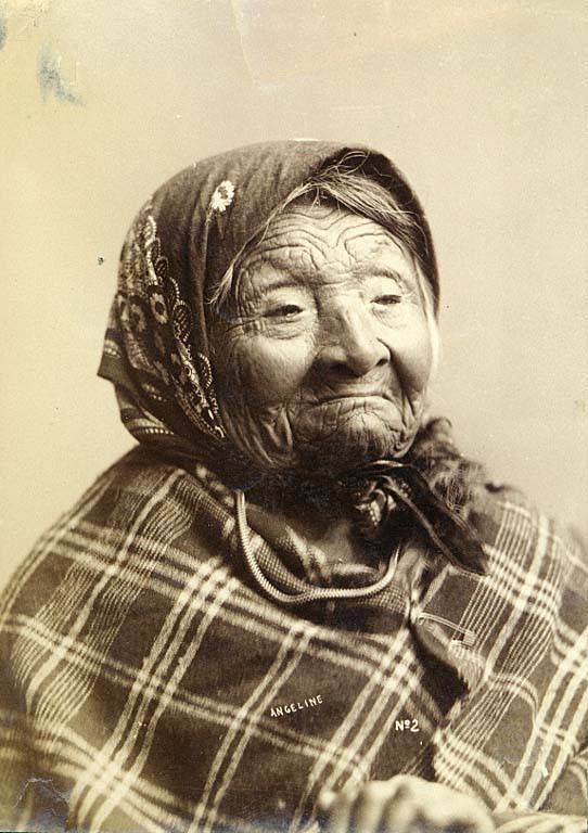
Princess Angeline was born Kikisoblu, the daughter of Si’ahl [siʔaɫ], better known in English as Chief Seattle of the Duwamish and Suquamish Tribes. Her date of birth is unknown; Wikipedia gives it as ca. 1820, whereas this article posted by the Duwamish Tribe, written by elementary school students based on HistoryLink essays, gives it as 1828. She died May 31, 1896.
Princess Angeline received her English name from Catherine Broshears Maynard, wife of David Swinson (“Doc”) Maynard, one of the earliest Seattle settlers. As the HistoryLink Elementary article puts it,
Chief Seattle’s oldest daughter was named Kikisoblu. She became friends with many of Seattle’s founding families. One of her friends was Catherine Maynard. She felt that Kikisoblu should have a name that would let the white settlers know that she was the daughter of a great chief. So she called her Princess Angeline. She thought that name was prettier than the name Kikisoblu.
Photograph of Princess Angeline (Kikisoblu), by Frank La Roche, ca. 1893
Born and raised in Seattle, Benjamin Donguk Lukoff had his interest in local history kindled at the age of six, when his father bought him settler granddaughter Sophie Frye Bass’s Pig-Tail Days in Old Seattle at the gift shop of the Museum of History and Industry. He studied English, Russian, and linguistics at the University of Washington, and went on to earn his master’s in English linguistics from University College London. His book of rephotography, Seattle Then and Now, was published in 2010. An updated version came out in 2015.
This street, which runs not quite a tenth of a mile from Ellis Avenue S in the west to 13th Avenue S in the east, was named by Angelo Boitano after himself as part of Boitano’s Supplemental Addition to the City of Georgetown in 1906. (Incidentally, if I ever had the opportunity to name a street after myself, I would call it Lukoff, not Benjamin.)
There isn’t much on the internet about him, but apparently he was interested in chestnut growing, and was in a bad buggy accident in 1908.
July 19, 1908 article in The Seattle Times on buggy accident that injured Boitano
Born and raised in Seattle, Benjamin Donguk Lukoff had his interest in local history kindled at the age of six, when his father bought him settler granddaughter Sophie Frye Bass’s Pig-Tail Days in Old Seattle at the gift shop of the Museum of History and Industry. He studied English, Russian, and linguistics at the University of Washington, and went on to earn his master’s in English linguistics from University College London. His book of rephotography, Seattle Then and Now, was published in 2010. An updated version came out in 2015.
Born and raised in Seattle, Benjamin Donguk Lukoff had his interest in local history kindled at the age of six, when his father bought him settler granddaughter Sophie Frye Bass’s Pig-Tail Days in Old Seattle at the gift shop of the Museum of History and Industry. He studied English, Russian, and linguistics at the University of Washington, and went on to earn his master’s in English linguistics from University College London. His book of rephotography, Seattle Then and Now, was published in 2010. An updated version came out in 2015.
This street runs just shy of 2,000 feet from NE Pacific Street in the west, just east of the University Bridge, to NE Columbia Road in the east, on the University of Washington South Campus.
Originally Lake Avenue in the 1890 Brooklyn Addition to Seattle, as it ran along the north shore of Lake Union, it became Northlake Avenue at some point between then and 1901, based on my search of Seattle Times, Seattle Star, and Seattle Post-Intelligencer archives. It starts being referred to as Northlake Way in 1935, though it seems this wasn’t formalized until 1956.
Portion of Map of Brooklyn Addition to Seattle, 1890, showing Lake Avenue (now NE Boat Street) and Railroad Avenue (now NE Pacific Street)
In 1960, Jerry Bryant of Bryant’s Marina proposed that all of Northlake Way — beginning far to the west, at the Fremont Bridge — receive the new name of Boat Street, but the 1962 ordinance establishing Boat Street only changes the name of the few blocks between the University Bridge and the UW campus. The Seattle P-I reports on December 22, 1960, that the Street Naming Committee of the Board of Public works rejected the proposal “because the present name is more descriptive,” but Bryant went ahead and filed his proposal with the City Council anyway in 1961.
According to The Seattle Times on May 24, 1962, the Board of Public Works once again asked the City Council to reject the proposal, which was “backed by more than 50 marine firms or individuals… [and] the University Commercial Club,” but on June 20, the Times reported that the City Council Streets and Sewers Committee approved the change. This met with much opposition. On July 2, the Times published a letter from Vince Lieb, 668 NE Northlake Way, that read, in part, that “numerous business firms… are more than a little chagrined at the City Council’s recent move… to please a minority of merchants who hawk their wares along the way,” and wondered if this might set a precedent:
We can think of such dandies as “Chop Suey Street,” “Gas and Oil Street,” “Beer Street,” and “Fish Street.” How about “Sand and Gravel Street” for a paved thoroughfare?
That same day, according to the P-I, the City Council postponed the implementation of the name change, sending it back to committee, and on July 10, according to the Times, the committee said it would give proponents and opponents two weeks to gather signatures, as the original petition had somehow been lost. Finally, on the 24th, they came up with a compromise: The name would be changed between the University Bridge and 15th Avenue NE only. This is where Bryant’s Marina was located, as well as the Jensen Motor Boat Company, which lasted until 2019 and was the last shipyard left on NE Boat Street.
From The Seattle Times, July 25, 1962
Today, Fritz Hedges Waterway Park — built on the former site of the marina — occupies most of the Boat Street waterfront.
Born and raised in Seattle, Benjamin Donguk Lukoff had his interest in local history kindled at the age of six, when his father bought him settler granddaughter Sophie Frye Bass’s Pig-Tail Days in Old Seattle at the gift shop of the Museum of History and Industry. He studied English, Russian, and linguistics at the University of Washington, and went on to earn his master’s in English linguistics from University College London. His book of rephotography, Seattle Then and Now, was published in 2010. An updated version came out in 2015.
Continuing the story we began in Hubbell Place, we take up W McLaren Street in Magnolia, which runs about 950 feet from Perkins Lane W in the west to 43rd Avenue W and W Ruffner Street in the east.
As was previously mentioned, the ordinance establishing Hubbell Place “accept[s] a deed of conveyance from George S. McLaren, et ux, and Helen Moore Hubbell” for the land. Who was this McLaren, and was he the namesake of W McLaren Street?
Photo of George S. McLaren that ran in the August 4, 1911, issue of The Seattle Times
George S. McLaren appears to have been on the finance committee of the 1909 Alaska–Yukon–Pacific Exposition, and Clarence Bagley’s History of Seattle from the Earliest Settlement to the Present Time notes that he was among the founders of Seattle’s Nile Shrine Temple in 1908. He is mentioned in the press as being an investment manager for the Northwestern Mutual Life Insurance Company, a founder of the Lake Chelan Land Company, and a representative of the Milwaukee Road in purchasing tideland real estate. And in February 1906, he was apparently one of the local businessmen who proclaimed, in the words of The Seattle Star, that “Something Will Be Done to Lift From the Shoulders of This City the Burden Placed There by the Sunset Telephone Co.,” and managed to get 2,000 similarly minded “long-suffering contributors to the yawning coffers of the Sunset concern” to assemble at the Grand Opera House to determine how best to “[remedy] the existing evil.”
In short, he does appear to have been, as The Hood River Glacier described him on August 10, 1911, “one of the leading business men of Seattle,” whose death “of ptomaine poisoning caused by eating canned mushrooms at a dinner at Tacoma” must have come as a great shock to the community.
As for W McLaren Street? It’s part of the Magnolia Heights subdivision, which was platted in 1907.
Advertisement for the Magnolia Heights subdivision in The Seattle Star, May 4, 1907
I thought it possible that George S. McLaren and W McLaren Street were related, but couldn’t be certain — nothing appeared in historical newspapers to definitively link the two. Then I looked him up in AncestryLibrary.com, which Seattle Public Library cardholders can access for free. And there it was! His probate records from 1911 contained an inventory of his assets, and among them were a “note of Magnolia Heights Co. for $333.33, dated September 5, 1907” and a “note of Parry Investment Co., for $155.64, dated July 17, 1907.” (Incidentally, both were valued at nil, though his total assets amounted to $367,228.76, or about $9.5 million in today’s money.)
Portion of inventory of the assets at death of George S. McLaren, from King County probate records via AncestryLibrary.com
As you can see in the newspaper advertisement above, the Parry Investment Company marketed lots in Magnolia Heights, which was platted by the Magnolia Heights Company. I’m willing on that basis to say that George McLaren’s name lives on in W McLaren Street.
Born and raised in Seattle, Benjamin Donguk Lukoff had his interest in local history kindled at the age of six, when his father bought him settler granddaughter Sophie Frye Bass’s Pig-Tail Days in Old Seattle at the gift shop of the Museum of History and Industry. He studied English, Russian, and linguistics at the University of Washington, and went on to earn his master’s in English linguistics from University College London. His book of rephotography, Seattle Then and Now, was published in 2010. An updated version came out in 2015.
This Industrial District street — a mere 80 feet long — runs from Airport Way S east to the Interstate 5 right-of-way. It may very well be the shortest street in Seattle (I’d love to hear about other candidates).
As explained in SW Seattle Street, the plat of Judkin’s Addition to the Town of Seattle was filed in 1869. From north to south, the east–west streets are named Norman, B, Judkins, Addition, Town, and Seattle. (Did they really think B Street would last, I wonder?)
Of these, Norman, Judkins, Addition, and Seattle Streets remain, though Addition is the only one still in its original location. (SW Seattle Street now only exists for a few blocks in West Seattle, and S Norman and S Judkins Streets only east of Interstate 5.)
Born and raised in Seattle, Benjamin Donguk Lukoff had his interest in local history kindled at the age of six, when his father bought him settler granddaughter Sophie Frye Bass’s Pig-Tail Days in Old Seattle at the gift shop of the Museum of History and Industry. He studied English, Russian, and linguistics at the University of Washington, and went on to earn his master’s in English linguistics from University College London. His book of rephotography, Seattle Then and Now, was published in 2010. An updated version came out in 2015.
This Queen Anne street runs 1½ miles from the meeting of 4th, Dexter, and Westlake Avenues N in the east (at the south end of the Fremont Bridge) to the 15th Avenue W interchange in the west. Some businesses in Fishermen’s Terminal have W Nickerson Street addresses, such as Chinook’s at 1900, but these few blocks of Nickerson are Port of Seattle roads that cannot be accessed directly from the public street.
Nickerson Street was named by Alfred A. Nickerson and Elmyra Nickerson, husband and wife, in their plat of Ross 2nd Addition to the City of Seattle in 1888.
Born and raised in Seattle, Benjamin Donguk Lukoff had his interest in local history kindled at the age of six, when his father bought him settler granddaughter Sophie Frye Bass’s Pig-Tail Days in Old Seattle at the gift shop of the Museum of History and Industry. He studied English, Russian, and linguistics at the University of Washington, and went on to earn his master’s in English linguistics from University College London. His book of rephotography, Seattle Then and Now, was published in 2010. An updated version came out in 2015.
This 600-foot-long street, which runs from Western to 2nd Avenues a block south of Bay Street, was given that name by William Nathaniel Bell in 1881. In his plat, the large lot between Bay (then Grant) and Lake (now Broad) Streets west of Western Avenue (then West Street) was shown as occupied by the Eagle Manufacturing Co. On this 1884 Sanborn map, though, “Seattle Barrel M’f’y” appears instead. This historic survey says that the Seattle Barrel Manufacturing Company opened in 1880, but was located between Bell and Wall Streets, farther south.
1881 plat1884 Sanborn map1912 Baist atlas
At any rate, it would seem that Eagle Street was named after this Eagle Manufacturing Co., of which I could find no further trace; and that neither Eagle nor Seattle Barrel was there 30 years later, when the 1912 Baist atlas was produced, showing the land to be occupied by Union Oil Company of California (later known as Unocal).
Unocal — which, according to Historylink, had begun using the lot in 1910 — would continue to use it as a fuel depot and marketing terminal until 1975. Cleanup of the contaminated ground began in the 1980s, and the Seattle Art Museum purchased the site in 1999 with help from the Trust for Public Land. In 2007, the Olympic Sculpture Park opened, completing the area’s transformation from open space to industrial area to open space once again.
(Local historian Paul Dorpat points out that the cove that once existed here could be [though never was] called “Eagle Cove” — both for Eagle Street and for the fact that Alexander Calder’s Eagle sculpture now makes its home in the lower half of the park.)
Born and raised in Seattle, Benjamin Donguk Lukoff had his interest in local history kindled at the age of six, when his father bought him settler granddaughter Sophie Frye Bass’s Pig-Tail Days in Old Seattle at the gift shop of the Museum of History and Industry. He studied English, Russian, and linguistics at the University of Washington, and went on to earn his master’s in English linguistics from University College London. His book of rephotography, Seattle Then and Now, was published in 2010. An updated version came out in 2015.
This street, which runs for a little over a tenth of a mile from Elliott to 1st Avenues, was originally named Grant Street by William Nathaniel Bell in 1881. 14 years later, it was one of the many streets caught up in the Great Renaming of 1895. Per ordinance 4044, it was “ordained… that the name of Grant Street from Elliott Bay to Depot Street, be and the same are hereby changed to Bay Street.” I can’t imagine it took its name from anywhere other than Elliott Bay.
Born and raised in Seattle, Benjamin Donguk Lukoff had his interest in local history kindled at the age of six, when his father bought him settler granddaughter Sophie Frye Bass’s Pig-Tail Days in Old Seattle at the gift shop of the Museum of History and Industry. He studied English, Russian, and linguistics at the University of Washington, and went on to earn his master’s in English linguistics from University College London. His book of rephotography, Seattle Then and Now, was published in 2010. An updated version came out in 2015.
This street, which runs, with interruptions, for 2⅓ miles from Queen Anne to just short of Elliott Bay in Magnolia (though it is platted for several more blocks west over the tideflats) is named, as I learned from the Ruffner Family Association, for Presbyterian minister William Henry Ruffner. A slaveholder who “advocated the gradual emancipation and colonization of the state’s African Americans”, he was also, according to Encyclopedia Virginia, “the designer and first superintendent of Virginia’s public school system.”
How did this “Horace Mann of the South” end up with his name on a Seattle street? Apparently, in addition to being an educator, he was also a geologist, and so was hired by Thomas Burke and Daniel Gilman (of Burke–Gilman Trail fame), two of the founders of the Seattle, Lake Shore and Eastern Railway, to spend just over five weeks in 1887 surveying the area, the results of which were published in the SLS&E’s promotional book A Report on Washington Territory two years later. When it came time in 1890 for the plat of Gilman’s Addition to the City of Seattle to be filed, Ruffner’s name appeared on the map.
The Seattle, Lake Shore and Eastern became part of the Northern Pacific Railway in 1892. Today, the Interbay Car Shop of the BNSF Railway, successor to the NP, is located at the corner of W Ruffner Street and Gilman Avenue W.
Born and raised in Seattle, Benjamin Donguk Lukoff had his interest in local history kindled at the age of six, when his father bought him settler granddaughter Sophie Frye Bass’s Pig-Tail Days in Old Seattle at the gift shop of the Museum of History and Industry. He studied English, Russian, and linguistics at the University of Washington, and went on to earn his master’s in English linguistics from University College London. His book of rephotography, Seattle Then and Now, was published in 2010. An updated version came out in 2015.
And the answer to the second is that it seems to have been subsumed in Roanoke Street when the Glenwilde Addition was platted in 1925. But North Street’s name was never changed.
(There did use to be an East Street and a West Street, too, as you can see on the full plat map. If I read the quarter section map correctly, East Street is now 24th Avenue E, and State Route 520 now covers the land where West Street would have been.)
Born and raised in Seattle, Benjamin Donguk Lukoff had his interest in local history kindled at the age of six, when his father bought him settler granddaughter Sophie Frye Bass’s Pig-Tail Days in Old Seattle at the gift shop of the Museum of History and Industry. He studied English, Russian, and linguistics at the University of Washington, and went on to earn his master’s in English linguistics from University College London. His book of rephotography, Seattle Then and Now, was published in 2010. An updated version came out in 2015.
What better way to start things off than with SW Seattle Street?
SW Seattle Street is a minor residential street in West Seattle that runs about ³/₁₀ of a mile from 42nd Avenue SW in the east to Sunset Avenue SW in the west.
It might seem strange that such a short street would be chosen to bear the city’s name — it was the only one to do so until 2010, when the first two blocks of Airport Way S were renamed Seattle Boulevard S — but this has more to do with unimaginative naming than with civic pride.
On August 4, 1869, Ike M. Hall — the executor of the estate of Norman B. Judkins — filed the Judkin’s (sic) Addition to the Town of Seattle, located just southwest of where the interchange between I-5 and I-90 is today. From north to south, the east–west streets are named Norman, B, Judkins, Addition, Town, and Seattle.
Portions of the original Seattle Street were vacated over the years (for example, in 1900, 1957, and 2000), and the construction of I-5 took care of the rest. However, when the city annexed West Seattle in 1907 it changed the name of Maple Street to W Seattle Street as part of rationalizing the street grid… and so the name lives on.
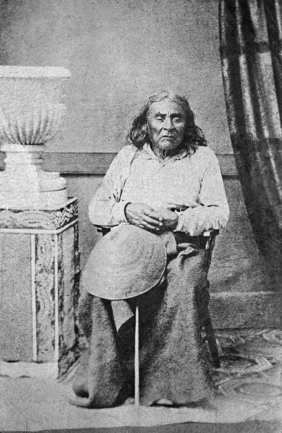
(The city itself, of course, was named after Si’ahl [siʔaɫ], better known in English as Chief Seattle of the Duwamish and Suquamish Tribes.)
The only known photograph of Chief Seattle (1786?–1866), taken by E.M. Sammis in 1864
So, why SW Seattle Street instead of Seattle Street SW?
In Seattle, east–west streets have the directional come first, and north–south avenues have it come last. The Wikipedia article “Street layout of Seattle,” which I helped write, has a more comprehensive description of Seattle’s addressing system, including the answer to this question:
Why was it W Seattle Street in 1907 but SW Seattle Street now?
In 1961, city ordinance 89910 “established a standard system of street name designations” so that in almost all cases streets within a given zone would carry the same directional. West Seattle avenues already carried the SW designation.
Born and raised in Seattle, Benjamin Donguk Lukoff had his interest in local history kindled at the age of six, when his father bought him settler granddaughter Sophie Frye Bass’s Pig-Tail Days in Old Seattle at the gift shop of the Museum of History and Industry. He studied English, Russian, and linguistics at the University of Washington, and went on to earn his master’s in English linguistics from University College London. His book of rephotography, Seattle Then and Now, was published in 2010. An updated version came out in 2015.


