E Crescent Drive

This street, created in 1905 as part of the plat of Interlaken, is so named because of its shape. Beginning at the intersection of Interlaken Drive E, 19th Avenue E, and E Galer Street, it goes nearly ⅓ of a mile northeast, then east, then southeast, to the intersection of 24th Avenue E and E Galer Street.

Eastmont Way W

Like its twin, Westmont Way W, this street was created in 1915 as part of the plat of Carleton Park, which “afford[ed] a scenic frontage for every building lot in the addition,” according to The Seattle Times. Just as Westmont faces the Olympic Mountains to the west and southwest, Eastmont faces the Cascades to the southeast.

Beginning at Eastmont Place, a pocket park at the south end of Westmont Way W, it goes around 850 feet northeast to W McGraw Street, where it becomes 36th Avenue W.

Westmont Way W

In Viewmont Way W, I discuss the 1915 plat of Carleton Park, in which, as The Seattle Times reported,

The streets and boulevards curve and swing about the bases of elevated portions, escaping the deep cuts and heavy fills that would be necessary in conforming to the strict, rectangular plans of the old plat, and affording a scenic frontage for every building lot in the addition.

Many streets in the subdivision were named in reference to these views, Westmont Way W among them. Beginning at Eastmont Place, a pocket park at the south end of Eastmont Way W, it goes ⅖ of a mile north, then northwest, to W Viewmont Way W, providing westerly and southwesterly views of the Olympic Mountains for its entire length.

NE Northgate Way

This street was named in 1968 for Northgate Station, which opened in 1950 as the Northgate Center shopping mall. According to HistoryLink.org, it was “the country’s first regional shopping center to be defined as a ‘mall’ (although there were at least three predecessor shopping centers).” Newspaper archives show that it became known early on as Northgate Mall, and that became its official name in 1974. As of this writing, the property is in the midst of a massive redevelopment project that began in 2019.

Prior to 1968, Northgate Way was known as (from west to east) N 105th Street, Mineral Springs Way N, N 110th Street, NE 110th Street, and Chelsea Place NE. Today, it begins at N 105th Street and Aurora Avenue N and goes 2⅕ miles east to NE 113th Street and Lake City Way NE.

The Northgate name itself has been attributed to Ben Erlichman. Feliks Banel writes:

Digging into the newspaper archives, The Seattle Times of February 22, 1948, published a big spread on the plans for the shopping center. The story quoted one of the developers, a local investor named Ben Ehrlichman (the uncle of future Watergate figure John Ehrlichman). “The name Northgate was chosen, Ehrlichman [told The Seattle Times], because the development ‘will be the most important northerly business district serving Seattle and vicinity and the gateway to metropolitan Seattle.’” Though a 30th anniversary story in the same paper in 1980 credited Ehrlichman for coming up with the name — based on the 1948 story — we may never know for certain whose idea it was.

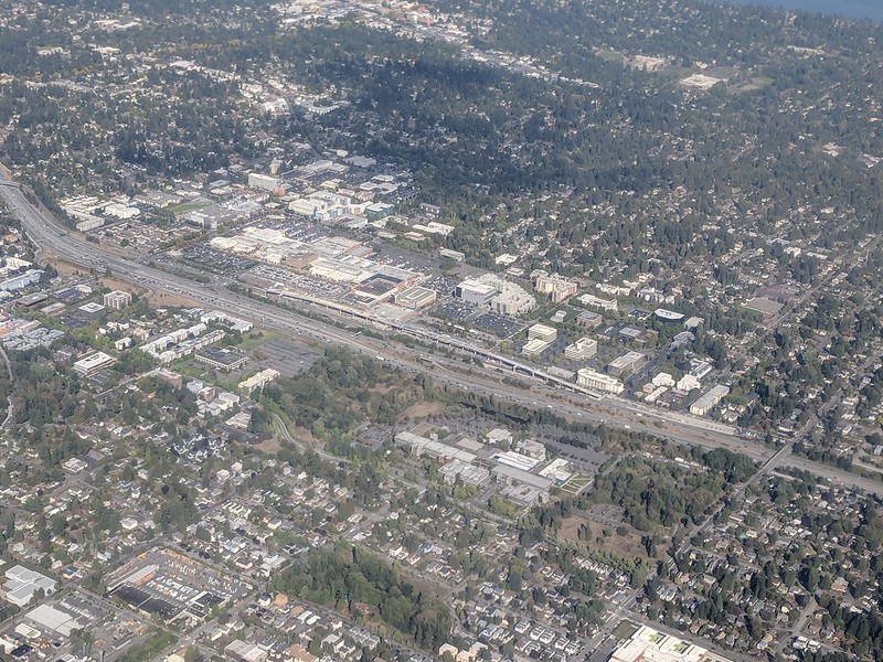
Aerial of Northgate, September 2018, from https://flickr.com/photos/25443792@N05/43844953055
Aerial of Northgate, September 2018, looking northeast. Interstate 5 cuts across the photo from bottom right to upper left. To its west is North Seattle College; to its east is Northgate Station, the Thornton Place complex, the Northgate Transit Center, and the Northgate commercial district. The elevated tracks of Sound Transit’s Line 1 light rail can be seen just east of the freeway. The Lake City commercial district is visible to the northeast of the mall; the greenbelt closer to the mall is one of the forks of Thornton Creek. Photograph by Flickr user Atomic Taco, licensed under Creative Commons Attribution-ShareAlike 2.0 Generic

Diagonal Avenue S

This street in the Industrial District is so named because it cuts diagonally across the street grid, going northeast–southwest rather than east–west or north–south. But why is it there in the first place?

In a sense, Diagonal Avenue has been around since the 1850s. As Sophie Frye Bass writes in Pig-Tail Days in Old Seattle,

The Beach or River Road… skirted the shore of the bay at the foot of the high Beacon Hill bluff, east of what is now Airport Way, and ran south along the Duwamish.… Built in the early fifties, [it] was a hard road to keep in good condition.… In 1886, a road was built on piling over the mud flats a little west of the Beach Road to avoid the slides and floods. This street became known as the Grant Street Bridge.

Essentially, there were a series of roads following the semicircular curve of Elliott Bay from Downtown to the Duwamish River before the tideflats were filled in: first Beach Road (or River Road), then the Grant Street Bridge, which in turn became Seattle Boulevard once the fill was complete. Sometime before 1918 (the first mention I could find of the name in The Seattle Times), the portion of Seattle Boulevard that ran northeast–southwest (the southern third of the semicircle) was renamed Diagonal Avenue. (In 1931, the rest of Seattle Boulevard was renamed Airport Way.)

Today, Diagonal Avenue S begins at Airport Way S and goes just about 400 feet to S Spokane Street. There is a slightly shorter segment west of 4th Avenue S which is blocked by railroad tracks, and one even shorter west of 2nd Avenue S blocked by the Union Pacific Railroad’s Argo Yard. It resumes for the last time at S Oregon Street, Colorado Avenue S, and Denver Avenue S, and goes ⅓ of a mile to sbəq̓ʷaʔ Park and Shoreline Habitat on the east bank of the Duwamish Waterway, which the Port of Seattle says “is probably the best small boat take-out launch site on the Lower Duwamish Waterway.”

S Southern Street

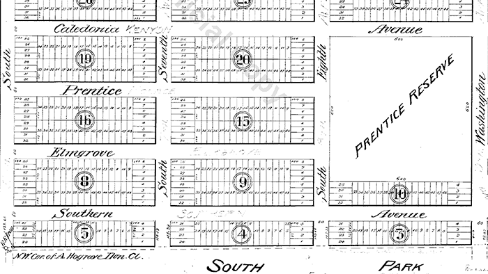
Having covered E North Street, Eastern Avenue N, and Western Avenue, we now come to S Southern Street! This street originated in the 1891 plat of River Park, filed by Alexander Prentice (1820–1909) and his wife, Jane Thomson Prentice (1823–1911). It appears to be so named simply because it is the southernmost street in the plat, half a block north of the 1890 plat of South Park.

Portion of River Park addition showing Southern Avenue (now Southern Street)

S Southern Street begins just east of 12th Avenue S on the west bank of the Duwamish Waterway, and goes ½ a mile to just west of 7th Avenue S, where it is blocked by Washington State Route 99 (W Marginal Way S). (Its first tenth of a mile is within unincorporated King County as part of the “Sliver by the River.”) It begins again in West Seattle as SW Southern Street at 35th Avenue SW, and goes ⅗ of a mile to 44th Avenue SW.

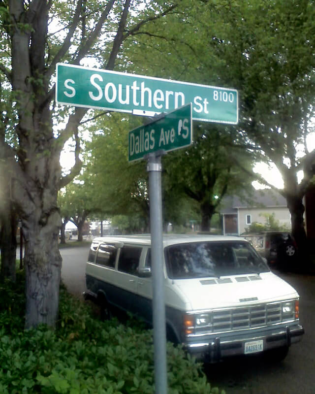
Sign at corner of S Southern Street and Dallas Avenue S, May 20, 2013
Signs at corner of S Southern Street and Dallas Avenue S, May 20, 2013. Photograph by Benjamin Lukoff. Copyright © 2013 Benjamin Lukoff. All rights reserved.

Western Avenue

This street appears to originate in this 1871 plat made by Arthur A. Denny. Unlike with E North Street or Eastern Avenue N, no mystery here: originally named West Street, it was the first street west of Front Street (today’s 1st Avenue). Front Street ran along the waterfront, as its name implied, south of about Seneca Street, but north of there the Elliott Bay shoreline curved and the street grid didn’t curve with it (that would happen farther north, at Stewart Street). Hence West Street, which was changed to Western Avenue in 1895. (West Street would be extended farther south once they started filling in the tideflats; today, it begins at Yesler Way.)

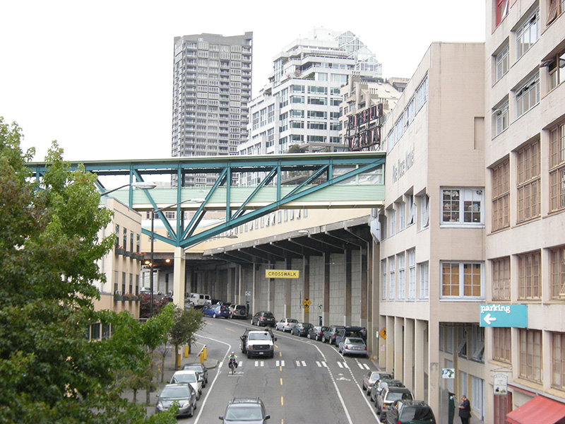
Western Avenue in Pike Place Market, October 2008
Western Avenue in Pike Place Market, October 2008. Photograph by Joe Mabel, Wikimedia Commons, licensed under Creative Commons Attribution-ShareAlike 3.0 Unported

Today, Western Avenue begins at Yesler Way and goes 1¾ miles northwest to Elliott Avenue W at 3rd Avenue W and W Thomas Street, having become Western Avenue W on crossing W Denny Way.

Eastern Avenue N

Just as with E North Street, one question that should spring to mind with a street name like this is Eastern side of what? — especially considering that it’s not too far from being equidistant from Lake Washington and Salmon Bay, measured along the east–west axis of 50th Street.

Local historian Rob Ketcherside explains in his blog post on “Renaming streets of Seattle’s Fremont to the U District”:

It was originally named East Street in the 1883 Lake Union Addition plat.… it was the street most east in the addition. That plat… [was] annexed into Seattle in 1891. Sometime apparently after 1893 and before 1895 East Street was renamed Eastern Avenue.… The streets running perpendicular to Eastern Avenue are labeled North until one block east. Then they are labeled Northeast. The first avenue east of Eastern is First Avenue Northeast. So the streets east of First Avenue Northeast are Northeast as well. Eastern Avenue and the avenues west are North.… Say that ten times fast.

So — Eastern Avenue is the easternmost avenue in the section of town where east–west streets carry the N prefix and north–south avenues carry the suffix N, though the actual dividing line is a block east at 1st Avenue NE.

Eastern Avenue N begins on Lake Union at Waterway 17, just south of N Northlake Way, where it essentially functions as a parking lot for the restaurant Westward (much like 5th Avenue NE, a few blocks to the east, does for Ivar’s Salmon House). It begins in earnest on the other side of the Burke–Gilman Trail at N Pacific Street and goes ⅞ of a mile north to N 50th Street.

Meridian Avenue N

As local historian Paul Dorpat writes in “Section lines on Wallingford Hill,”

The meeting of 45th Street and Meridian Avenue began in the forest, when federal surveyors carrying their Gunter chains described — and marked — the future streets as the west (Meridian) and north (45th) borders for the 640 acres of federal land section number 17. That done, the settlers could identify their claims with some precision.

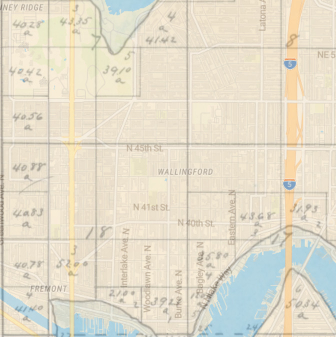
Indeed, King County’s quarter section map covering the intersection shows that (going clockwise) sections 7, 8, 17, and 18 of Township 25 North, Range 4 East, Willamette Meridian, meet there.

This means Meridian Avenue N is named after meridian, but not the Willamette Meridian (which, once it reaches the latitude of Seattle, is on the Kitsap Peninsula), the Puget Sound Meridian, or the City Standard Meridian. As this overlay map I made shows (see below for the section of the map showing the intersection of 45th and Meridian), Fairview Avenue N follows the same alignment between Denny Way and Valley Street.

Overlay of 1863 cadastral survey of Township 025-0N Range 004-0E, Willamette Meridian, with modern map of Seattle, showing alignment of Meridian Avenue N and N 45th Street with section lines
Overlay of 1863 cadastral survey of Township 25 North, Range 4 East, Willamette Meridian, from the Bureau of Land Management, and modern map of Seattle, showing alignment of Meridian Avenue N and N 45th Street with section lines, generated at Georeferencer.com

Meridian Avenue N begins at N Northlake Way just north of Gas Works Park and goes 1½ miles north to N 55th Street, where it becomes Kenwood Place N. It resumes at Kirkwood Place N just north of N 59th Street, and goes ¼ mile north to E Green Lake Way N. On the north side of the lake, there is a block-long stretch from E Green Lake Drive N to N 75th Street, and a longer, ¾-mile one from N 77th Street to N 92nd Street and North Seattle College. Meridian begins again at the north end of College Way N at N 103rd Street, and goes just under a mile to N 122nd Street, south of Haller Lake. It resumes on the north shore of the lake as a shoreline street end (though not on the city’s official list) and goes a mile north to the city limits at N 145th Street. As with most North Seattle avenues, the name continues into Shoreline, and in this case the arterial street itself keeps going for 3 more miles to the King–Snohomish county line at N 205th Street.

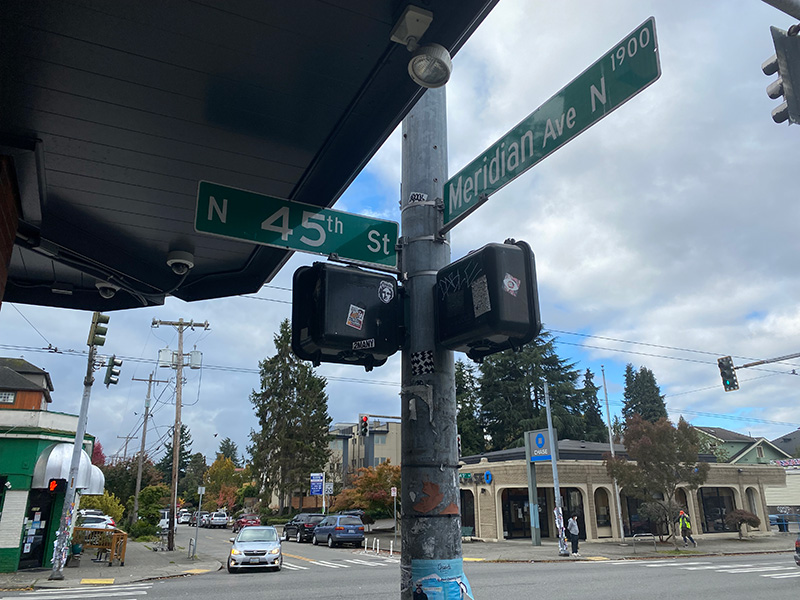
Street sign at N 45th Street and Meridian Avenue N, Seattle, October 13, 2021
Street sign at N 45th Street and Meridian Avenue N, Seattle. Photograph by Benjamin Lukoff, October 13, 2021. Copyright © 2021 Benjamin Lukoff. All rights reserved.

NW North Beach Drive

This short street runs just over 750 feet from Triton Drive NW in the west to NE 98th Street in the east, just west of 24th Avenue NW. It was established in 1926 as part of North Beach, an Addition to the City of Seattle; at the time, it extended farther south, but that section is now 26th Avenue NW. The beach being referred to is on Puget Sound, across the BNSF Railway tracks from what is now NW Esplanade.

Although it bears the neighborhood’s name, houses along North Beach Drive are actually only eligible for associate, not full, membership in the North Beach Club, as the community boundary map shows. This is because the club, which originated in 1927 as the Golden View Improvement Club, was formed by and for residents of the Golden View and Golden View Division № 2 subdivisions, platted in 1924 and 1926, respectively. (According to state records, the GVIC was administratively dissolved in 1982 and merged into the North Beach Club [founded 1990] in 2006. [No word on what entity managed affairs from 1982 to 1990.]) In 1930, the club took over responsibility for the subdivisions’ water system from the developer, who as part of the deal deeded 1,500 feet of Puget Sound beach to the organization. It is this private beach, accessible via a short path from NW Esplanade at 28th Avenue NW, that is the North Beach Club’s primary raison d’être today, the water system having been hooked into the city supply long ago. Today’s associate members are the “descendants” of those who were interested in the Golden View additions’ water system 91 years ago but lived outside the subdivision boundaries — including residents of NW North Beach Drive.

Westlake Avenue

Forming a trio with Eastlake Avenue and Northlake Way, Westlake Avenue is so named for running along the western shore of Lake Union. Beginning today at Stewart Street between 5th Avenue and 6th Avenue, just north of McGraw Square, it runs 2½ miles north to 4th Avenue N between Nickerson Street and Florentia Street — the south end of the Fremont Bridge.

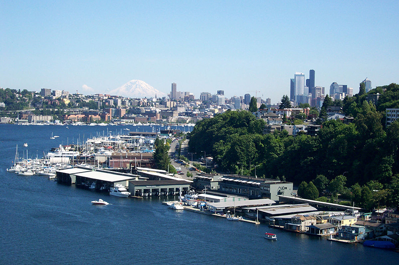
Westlake neighborhood and Mount Rainier from the Aurora Bridge, June 23, 2006
Westlake neighborhood and Mount Rainier from the Aurora Bridge, June 23, 2006. Photograph by Flickr user Steve Voght, licensed under Creative Commons Attribution-ShareAlike 2.0 Generic

Westlake Avenue once started a couple of blocks to the south, at 4th Avenue and Pike Street, and based on the quarter section map, it appears that its former route through Westlake Park between Pike Street and Pine Street is still public right-of-way as opposed to park land. (The portion between Pine Street and Olive Way was vacated in 1986 to make way for the Westlake Center mall, which opened in 1988, and the portion between Olive Way and Stewart Street was closed in 2010 to allow for the expansion of McGraw Square.)

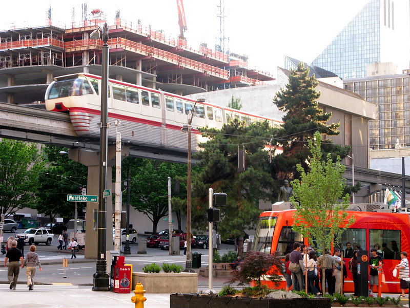
Monorail and streetcar, corner of Westlake Avenue and Olive Way, in 2008
Monorail and streetcar, corner of Westlake Avenue and Olive Way, in 2008. Photograph by Flickr user Oran Viriyincy, licensed under Creative Commons Attribution-ShareAlike 2.0 Generic

Westlake was extended south to 4th and Pike from Denny Way in 1902 (one former mayor has called for that extension to be closed to cars); the original Westlake Avenue (now, properly, Westlake Avenue N) was created in 1895 as part of the Great Renaming ordinance, Section 5 of which reads

That the names of Rollin Street, Lake Union Boulevard and Lake Avenue from Depot Street [changed by the same ordinance to Denny Way] to Florentia Street, be and the same are hereby changed to Westlake Avenue.

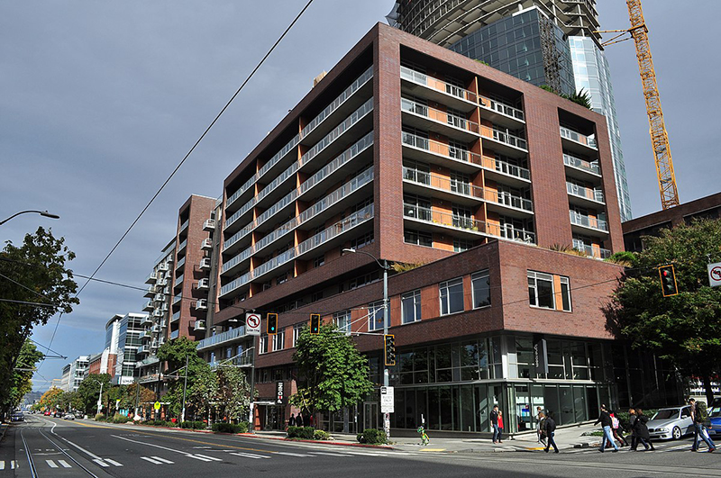
Rollin Street, the southernmost portion, was named for Rolland Herschel Denny (1851–1939), the youngest member of the Denny Party at just six weeks old. In its honor, an apartment complex that opened at the corner of Westlake and Denny in 2008 is named Rollin Street Flats.

Rollin Street Flats, northeast corner of Westlake Avenue N and Denny Way, South Lake Union
Rollin Street Flats, northeast corner of Westlake Avenue N and Denny Way, South Lake Union, October 22, 2017. Photograph by Joe Mabel, Wikimedia Commons, licensed under Creative Commons Attribution-ShareAlike 4.0 International

Northlake, Eastlake, Westlake… why no Southlake?

Having covered Northlake, Eastlake, and Westlake so far, one might ask: why is there no Southlake?

There does appear to have been a Southlake Avenue for a time — 1909 to 1924 or so, based on the last mention of it I could find in Seattle newspapers, an article in the August 8, 1924, edition of The Seattle Times on a car crash that had taken place a number of weeks earlier. Now the northern section of Fairview Avenue N, it extended from the intersection of Valley Street northwest to E Galer Street and Eastlake Avenue E, “thus eliminating the present grade on Eastlake for University traffic” in the words of a real estate advertisement in the August 23, 1914, edition of the Seattle Post-Intelligencer. But why the Southlake name disappeared seems clear: once it was decided to extend the Fairview name along the shore lands, there was no other appropriate road to carry it. The northern and eastern shores of Lake Union are just shy of 2 miles long each, but since the lake is shaped like a ? (and, surprisingly, like a uterus if Portage Bay is included) there is hardly any southern shore to speak of — only about ¼ mile.

As for the neighborhood name, I’m not sure why South Lake Union came to be used instead of Southlake. Perhaps it’s as simple as the lack of a similarly named street to “anchor” the neighborhood.

Eastlake Avenue E

Like NE Northlake Way, Eastlake Avenue E is so named because it runs along the shore of Lake Union — in this case, obviously, the eastern one. It, too, was earlier named Lake Avenue (in part), but this was changed as part of the Great Renaming of 1895. Ordinance 4044, Section 6 reads

That the names of Albert Street, Waterton Street, Lake Avenue and Green Street from Depot Street [changed by the same ordinance to Denny Way] to the shore of Lake Union at the northerly point of the Denny–Fuhrman addition, be and the same are hereby changed to Eastlake Avenue.

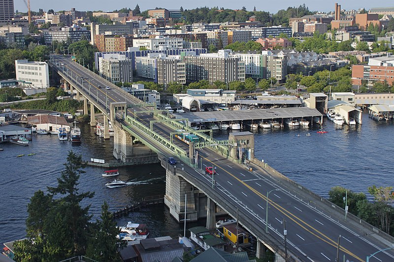
Today, Eastlake, at 2⁹⁄₁₀ miles in length, extends slightly farther north and south than the roadway mentioned in the ordinance. It starts in the south at the intersection of Court Place and Howell Street as Eastlake Avenue, then becomes Eastlake Avenue E a block north as it crosses Denny Way. From here to just south of E Galer Street it divides the Avenue: E; Street: E section of town from the Avenue: N; Street section. Just north of Portage Bay Place E it crosses Lake Union as the University Bridge, then continues on as the one-way–northbound Eastlake Avenue NE to 11th Avenue NE just north of NE 41st Street. (Southbound, it is fed by Roosevelt Way NE at NE Campus Parkway.)

Eastlake, like Fairview and Boren Avenues, is one of the few north–south streets in Seattle to have three different directional designations.

Looking northeast at the University Bridge from the Ship Canal Bridge in Seattle, July 2018
Looking northeast at the University Bridge from the Ship Canal Bridge, July 2018. Photograph by SounderBruce, Wikimedia Commons, licensed under Creative Commons Attribution-Share Alike 4.0 International

NE Northlake Way

As explained in NE Boat Street, NE Northlake Way was originally Lake Avenue in the 1890 Brooklyn Addition to Seattle, so named because it ran along the northern shore of Lake Union. I couldn’t find an ordinance changing its name from Lake Avenue (used elsewhere, notably for what are now Westlake Avenue and Fremont Avenue N and for part of Eastlake Avenue E) to Northlake Avenue, but the latter name begins to appear in local newspapers in 1901. (Complicating matters slightly, the street appears as North Lake Avenue in the state’s 1907 plat of Lake Union Shore Lands.) Northlake Avenue began being referred to as Northlake Way in 1935, and this was made official in 1956.

Today, NE Northlake Way begins at the west end of NE Pacific Street under the University Bridge at Eastlake Place NE, and continues 1½ miles west to just shy of the Aurora Bridge, where it becomes a private road through formerly industrial land developed by the Fremont Dock Company into a business park. (The Puget Sound Business Journal and The Seattle Times have good articles on how over the years Suzie Burke transformed her father’s Burke Millwork Co., which opened in 1939, into what is today home to local offices for Google and Adobe and corporate headquarters for Tableau and Brooks Sports, among other tenants.) This private roadway continues for ⅖ of a mile beyond the end of the public right-of-way to the intersection of N Canal Street, N 34th Street, and Phinney Avenue N.

NE Northlake Way once began ⅖ of a mile further east, at NE Columbia Road on the University of Washington South Campus, but this stretch was changed to NE Boat Street in 1962, not without some controversy.

Occidental Avenue S

Occidental Avenue S, which begins at Yesler Way in Pioneer Square, is one of those Seattle streets whose names extend into the suburbs. It makes its southernmost appearance at S 197th Street in Des Moines.

It received its name in 1895 as part of the Great Renaming — it had originally been S Second Street. It once had a partner, Oriental Avenue, to the east (originally S Fourth Street), which is today 3rd Avenue S. “Oriental,” of course, means “Eastern,” as “Occidental” means “Western.” (I haven’t been able to determine just when Oriental Avenue became 3rd, but it was last mentioned in The Seattle Times on October 17, 1920.)

And why this particular pairing? The Occidental Hotel, which once overlooked the beginning of Occidental Avenue, is almost certainly the reason, but it’s not spelled out in the ordinance.

E North Street

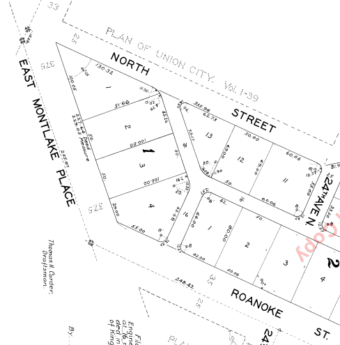
Seattle has a number of streets whose names incorporate directions, such as Northlake Way, Eastern Avenue, Eastlake Avenue, Western Avenue, Westlake Avenue, and Southern Street. But the one I drove by most growing up — and the only one to simply bear the name of a direction in its uncompounded, nominal form — is E North Street, which runs between E Montlake Place E and 24th Avenue E in Montlake, just south of the 520 interchange.

Two questions should spring to mind with a street name like this: North of what? and What happened to South Street?

Portion of Plan of Union City, 1869

The answer to the first question is north of where Harvey Lake Pike, son of John Henry Pike of Pike Street fame, had planned to dig a canal between Union Bay and Portage Bay.

And the answer to the second is that it seems to have been subsumed in Roanoke Street when the Glenwilde Addition was platted in 1925. But North Street’s name was never changed.

(There did use to be an East Street and a West Street, too, as you can see on the full plat map. If I read the quarter section map correctly, East Street is now 24th Avenue E, and State Route 520 now covers the land where West Street would have been.)