Like NW Sloop Place, its twin on the south side of Salmon Bay Park, this street was created in 1890 as part of the plat of Salmon Bay Park, which featured east–west streets after watercraft: Schooner, Canoe, Sloop, Brig, and Ship. When Seattle annexed Ballard in 1907, these streets became 75th, 73rd, 70th, 67th, and 65th Streets, respectively, but the names of Sloop and Canoe were preserved: South Park Place became Sloop Place and North Park Place became Canoe Place.
Today, NW Canoe Place begins at 21st Avenue NW, at the northwest corner of the park, and goes two blocks east — just over 500 feet — to 19th Avenue NW, at its northeast corner.
Born and raised in Seattle, Benjamin Donguk Lukoff had his interest in local history kindled at the age of six, when his father bought him settler granddaughter Sophie Frye Bass’s Pig-Tail Days in Old Seattle at the gift shop of the Museum of History and Industry. He studied English, Russian, and linguistics at the University of Washington, and went on to earn his master’s in English linguistics from University College London. His book of rephotography, Seattle Then and Now, was published in 2010. An updated version came out in 2015.
When Elon W. Denton filed the plat of Salmon Bay Park in 1890, he named his east–west streets after watercraft: Schooner, Canoe, Sloop, Brig, and Ship. To the north of Salmon Bay Park was North Park Place, and to its south, South Park Place.
The annexation of Ballard by Seattle in 1907 required that Denton’s street names be changed. Sloop Street became 70th Street, but its name was preserved by changing South Park Place to Sloop Place. (To the north of the park, North Park Place became Canoe Place.)
Today, NW Sloop Place begins at 21st Avenue NW, at the southwest corner of the park, and goes two blocks east — just over 500 feet — to 19th Avenue NW, at its southeast corner.
Born and raised in Seattle, Benjamin Donguk Lukoff had his interest in local history kindled at the age of six, when his father bought him settler granddaughter Sophie Frye Bass’s Pig-Tail Days in Old Seattle at the gift shop of the Museum of History and Industry. He studied English, Russian, and linguistics at the University of Washington, and went on to earn his master’s in English linguistics from University College London. His book of rephotography, Seattle Then and Now, was published in 2010. An updated version came out in 2015.
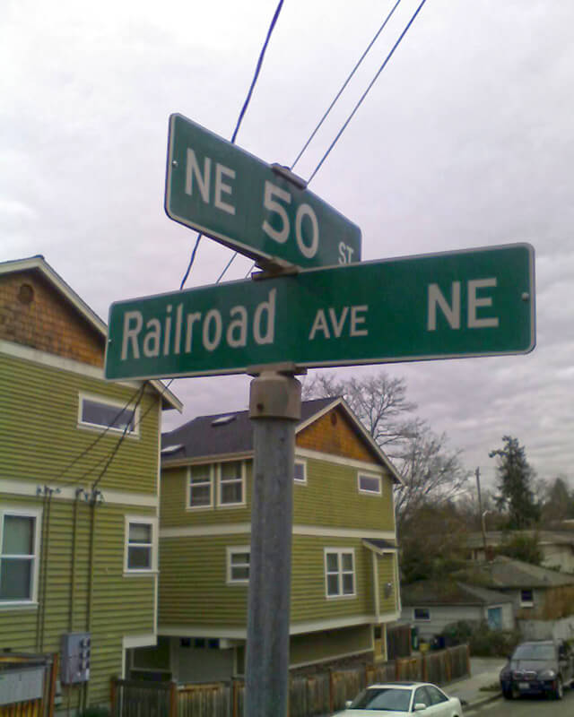
This street was created in 1946 by Ordinance 75507, “an ordinance accepting a deed from Eva M. Barquist, a spinster, to the City of Seattle for street purposes and laying off East 50th Street and Railroad Avenue Northeast.” This restored the Railroad Avenue NE name to a very short street on the east side of the Northern Pacific tracks, six years after it was changed to NE Blakely Street on the west side.
Railroad Avenue NE begins at NE 50th Street just east of 39th Avenue NE and goes 90 feet south to a dead end, essentially serving as a driveway for a cluster of townhouses.
Born and raised in Seattle, Benjamin Donguk Lukoff had his interest in local history kindled at the age of six, when his father bought him settler granddaughter Sophie Frye Bass’s Pig-Tail Days in Old Seattle at the gift shop of the Museum of History and Industry. He studied English, Russian, and linguistics at the University of Washington, and went on to earn his master’s in English linguistics from University College London. His book of rephotography, Seattle Then and Now, was published in 2010. An updated version came out in 2015.
Airport Way S does not, as one might expect, go from the city to Seattle–Tacoma International Airport (known to locals as Sea–Tac), but rather to King County International Airport (better known as Boeing Field). It got its current name in 1931 at the request of the Georgetown-South Seattle Improvement Club, which, according to an article in the April 12 issue of The Seattle Times,
…asked the City Council to merge portions of Seattle Boulevard, Eighth and Ninth Avenues South and Duwamish Avenue, leading from the central business area to Boeing Field, into a new highway, to be known as Airport Way.… [They contended] that strangers are confused in efforts to find the airport by lack of any specifically designated street leading to it.
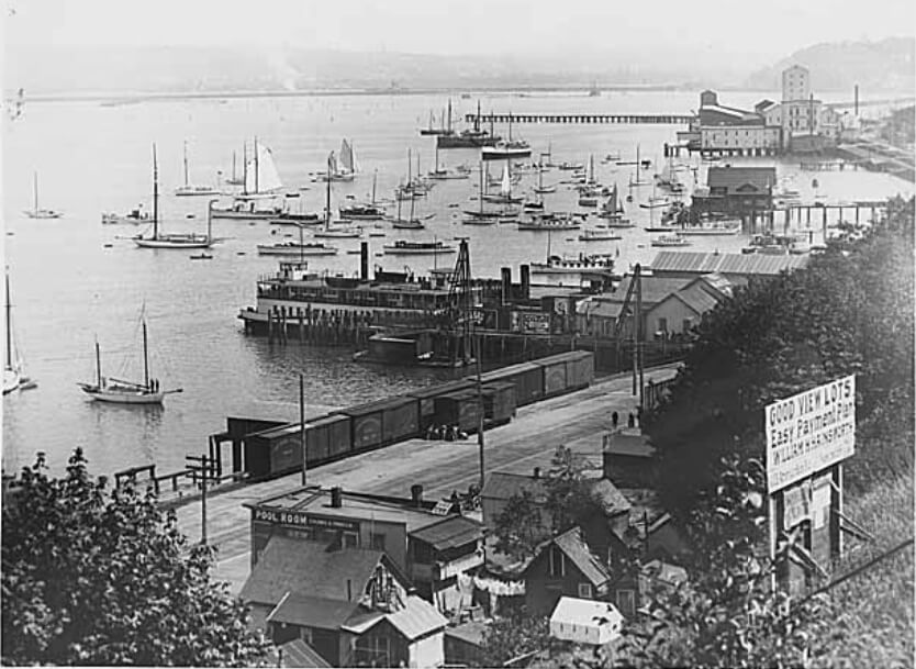
The Beach or River Road… [which] skirted the shore of the bay at the foot of the high Beacon Hill bluff, east of what is now Airport Way, and ran south along the Duwamish.… Built in the early fifties, [it] was a hard road to keep in good condition.… In 1886, a road was built on piling over the mud flats a little west of the Beach Road to avoid the slides and floods. This street became known as the Grant Street Bridge.
Essentially, there were a series of roads following the semicircular curve of Elliott Bay from Downtown to the Duwamish River before the tideflats were filled in: first Beach Road (or River Road), then the Grant Street Bridge, which in turn became Seattle Boulevard once the fill was complete. Sometime before 1918… the portion of Seattle Boulevard that ran northeast–southwest (the southern third of the semicircle) was renamed Diagonal Avenue. (In 1931, the rest of Seattle Boulevard was renamed Airport Way.)
This photograph, taken circa 1900 by Anders Beer Wilse, looks northwest from Beacon Hill over the Grant Street Bridge and the Elliott Bay tideflats. At upper left is West Seattle; at upper right is Magnolia. From this perspective, Downtown Seattle appears just below Magnolia. Bainbridge Island is in the distance across Puget Sound.
Once Sea–Tac fully opened in 1949, Airport Way S no longer led to the region’s primary airport, which was more directly reached via U.S. 99, but no further name changes took place.
Today, Airport Way S begins at Seattle Boulevard S and 6th Avenue S and goes 6⅗ miles southeast, then south, then southeast again, ending at Boeing Access Road. Its lower 2½ miles parallel the eastern boundary of Boeing Field.
Born and raised in Seattle, Benjamin Donguk Lukoff had his interest in local history kindled at the age of six, when his father bought him settler granddaughter Sophie Frye Bass’s Pig-Tail Days in Old Seattle at the gift shop of the Museum of History and Industry. He studied English, Russian, and linguistics at the University of Washington, and went on to earn his master’s in English linguistics from University College London. His book of rephotography, Seattle Then and Now, was published in 2010. An updated version came out in 2015.
This street, created in 1888 as part of the First Plat of West Seattle by the West Seattle Land and Improvement Company, was originally named Grand Avenue. It was renamed, along with many other West Seattle streets, in 1907, when West Seattle was annexed by Seattle. The name was a reference to the WSL&IC ferry terminal at what is today Harbor Avenue SW at California Way SW. The West Seattle Water Taxi has been operating from the same location since 1997.
Today, Ferry Avenue SW begins at California Way SW and goes about ³⁄₇ of a mile southwest to just past California Avenue SW, at California Place park (built on the site of a former streetcar terminal; before that, a cable car ran up the Ferry Avenue right-of-way from Elliott Bay to this location). It resumes on the other side of the park at SW Hill Street and goes a further 600 feet southwest to SW Walker Street.
Born and raised in Seattle, Benjamin Donguk Lukoff had his interest in local history kindled at the age of six, when his father bought him settler granddaughter Sophie Frye Bass’s Pig-Tail Days in Old Seattle at the gift shop of the Museum of History and Industry. He studied English, Russian, and linguistics at the University of Washington, and went on to earn his master’s in English linguistics from University College London. His book of rephotography, Seattle Then and Now, was published in 2010. An updated version came out in 2015.
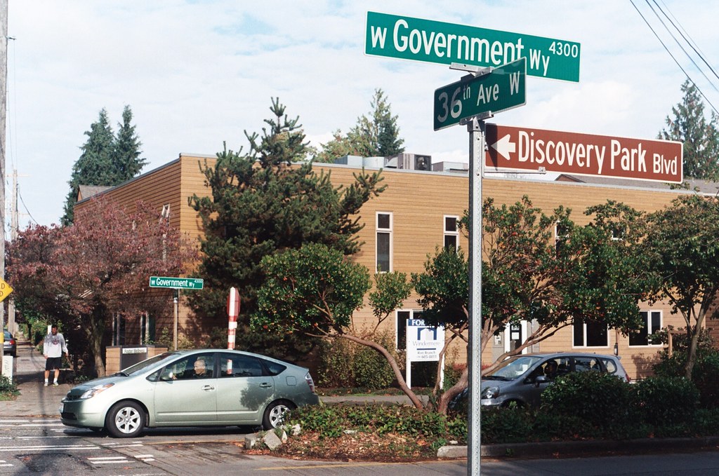
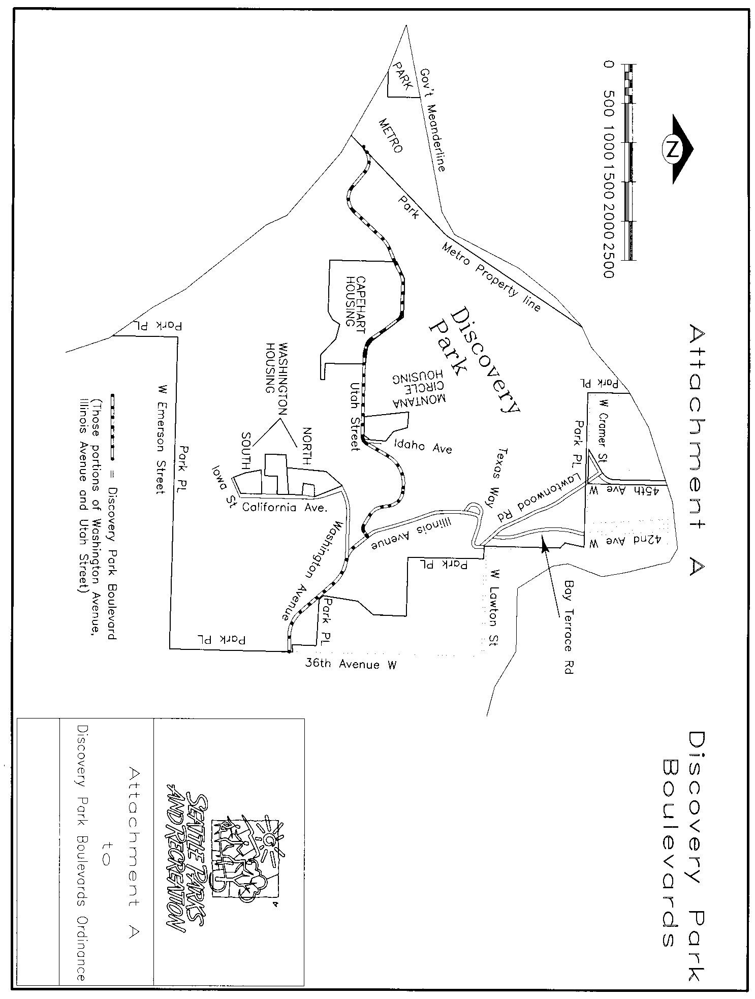
Unlike Seattle’s other park boulevards, Discovery Park Boulevard is of recent creation. Ordinance 122503, passed in 2007, designated numerous streets within the park as park boulevards, one reason being that:
Public safety will be enhanced within Discovery Park as traffic codes and regulations are fully enforceable on Park Boulevards as they are on City of Seattle streets, but not necessarily on park roads which are considered “private.”
(More on this at Lawtonwood Road.) Among the streets so designated were Lawtonwood Road, Bay Terrace Road, Utah Street, Washington Avenue, California Avenue, Iowa Street, Illinois Avenue, Texas Way, Idaho Avenue, and 45th Avenue W. The ordinance specified that Washington Avenue from the park entrance to Illinois Avenue; Illinois Avenue from there to Utah Street; and Utah Street from there to King County’s West Point Treatment Plant were to be known as Discovery Park Boulevard (see this map for an illustration).
The person who first suggested the name “Discovery Park” was U.S. District Judge Donald S. Voorhees, who had led the effort to create a park at Fort Lawton in 1968…. Voorhees was a student of Puget Sound history and Vancouver’s exploration. But he was also an avid follower of the philosophy of Frederick Law Olmsted, the famed American landscape architect. Voorhees believed the name combined the history of Vancouver’s exploration of Puget Sound on the HMS Discovery with the excitement of visitors when they discover the wonders of nature in the Park. When asked to make a choice between the meanings, Voorhees would choose the experience of “discovery” by citizens, particularly children, visiting the Park for the first time, over the historical connection with the HMS Discovery.
Born and raised in Seattle, Benjamin Donguk Lukoff had his interest in local history kindled at the age of six, when his father bought him settler granddaughter Sophie Frye Bass’s Pig-Tail Days in Old Seattle at the gift shop of the Museum of History and Industry. He studied English, Russian, and linguistics at the University of Washington, and went on to earn his master’s in English linguistics from University College London. His book of rephotography, Seattle Then and Now, was published in 2010. An updated version came out in 2015.
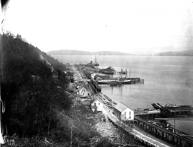
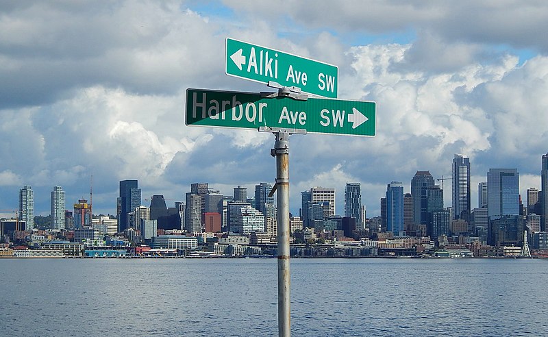
As noted in Alaskan Way, Harbor Avenue SW was once part of Railroad Avenue. When the Elliott Bay tidelands were platted in 1895, Railroad Avenue stretched from (using current landmarks) the Magnolia Bridge along the waterfront to the Industrial District, then across Harbor Island to West Seattle, ending southwest of Duwamish Head. In 1907 the West Seattle portion was renamed Alki Avenue, and sometime between 1912 and 1920 it was given its current name.
Looking northwest up what is now Harbor Avenue SW toward Duwamish Head, April 1902
Today, Harbor Avenue SW begins at SW Avalon Way and SW Spokane Street at the west end of the West Seattle Bridge and goes 1¾ miles northwest to Duwamish Head, where it becomes Alki Avenue SW.
Born and raised in Seattle, Benjamin Donguk Lukoff had his interest in local history kindled at the age of six, when his father bought him settler granddaughter Sophie Frye Bass’s Pig-Tail Days in Old Seattle at the gift shop of the Museum of History and Industry. He studied English, Russian, and linguistics at the University of Washington, and went on to earn his master’s in English linguistics from University College London. His book of rephotography, Seattle Then and Now, was published in 2010. An updated version came out in 2015.
This street appears to have been built sometime between 1908 and 1912. (It was established by ordinance in 1906, but that was legislation, not construction. [It was also originally named Ewing Street, the original name of N 34th Street, which still exists on the Queen Anne side of the Ship Canal.]) When the plat of Denny & Hoyt’s Addition to the City of Seattle, W.T., was filed in 1888, no such street was needed, because there was no canal. Instead, Ross Creek connected Lake Union to Salmon Bay. However, as work on the Lake Washington Ship Canal progressed, the Fremont Cut came into being, and it must have been felt a street paralleling the canal to the north was needed, since the original plat took no notice of the creek or any future canal route. (One to the south was needed, too, which is why Nickerson Street was extended from 3rd Avenue W to 4th Avenue N, at the southern end of the Fremont Bridge.)
Why, then, is Canal Street so short — not quite ⅓ of a mile from N 34th Street and Phinney Avenue N in the east to 2nd Avenue NW in the west?
As it turns out, even though Canal Street was to run to what was then the boundary between the cities of Seattle and Ballard at 8th Avenue NW, shortly after Seattle annexed Ballard in 1907 another street was laid out parallel to the canal connecting Fremont to the new neighborhood of Ballard: Leary Way NW (then simply Leary Avenue, all the way from Market Street to Fremont Avenue). Leary became the main arterial, and in 1951 NW Canal Street was vacated between 3rd Avenue NW and 8th Avenue NW, reducing it to its present length. (Until 2016, there was a slight discontinuity in the vicinity of 1st Avenue NW and N 35th Street where the built street deviated from its right-of-way, making it even shorter.)
So this isn’t quite the same as our trio of S Front Street, S River Street, and S Riverside Drive literally being cut short by the rechanneling of the Duwamish River into the Duwamish Waterway — more one of Canal Street being supplanted by Leary Way and becoming more valuable to the city as industrial land than as roadway.
Born and raised in Seattle, Benjamin Donguk Lukoff had his interest in local history kindled at the age of six, when his father bought him settler granddaughter Sophie Frye Bass’s Pig-Tail Days in Old Seattle at the gift shop of the Museum of History and Industry. He studied English, Russian, and linguistics at the University of Washington, and went on to earn his master’s in English linguistics from University College London. His book of rephotography, Seattle Then and Now, was published in 2010. An updated version came out in 2015.
The sleek Latona was originally built as a pleasure craft for businessman James Colman to use on the Sound. Dr. E.C. Kilbourne, a dentist with extensive real estate holdings north of Lake Union, purchased the Latona and took her to Lake Washington by way of the Duwamish River and Black River, the lake’s outlet. After a few years of serving farms, mining camps, and logging operations around Lake Washington, the Latona came through the narrow channel dug in 1886 to Portage Bay and thereafter served Lake Union.
Today, Latona Avenue NE begins as a shoreline street end just south of NE Northlake Way and goes nearly 1¾ miles north to 2nd Avenue NE and Woodlawn Avenue NE near the eastern end of Green Lake. It reappears on the other side of the Green Lake Park playground and community center at E Green Lake Drive N, and goes a further ⅓ of a mile to just past NE 77th Street, where it is stopped by Interstate 5. Finally, on the north side of I-5, it goes nearly ½ a mile from NE 81st Street to NE 91st Street, interrupted by a half-block segment just north of NE 88th Street where it takes the form of a footpath, and a half-block segment just north of NE 90th Street where it appears to have been incorporated into neighbors’ yards and driveways.
Latona Avenue NE right-of-way between NE 90th Street and NE 91st Street in Maple Leaf. The northern half is paved, but ends at an unpaved alley; the southern half appears to be serving as neighbors’ driveways at either end, the remainder being treated as part of their yards.
Born and raised in Seattle, Benjamin Donguk Lukoff had his interest in local history kindled at the age of six, when his father bought him settler granddaughter Sophie Frye Bass’s Pig-Tail Days in Old Seattle at the gift shop of the Museum of History and Industry. He studied English, Russian, and linguistics at the University of Washington, and went on to earn his master’s in English linguistics from University College London. His book of rephotography, Seattle Then and Now, was published in 2010. An updated version came out in 2015.
This street runs just shy of 2,000 feet from NE Pacific Street in the west, just east of the University Bridge, to NE Columbia Road in the east, on the University of Washington South Campus.
Originally Lake Avenue in the 1890 Brooklyn Addition to Seattle, as it ran along the north shore of Lake Union, it became Northlake Avenue at some point between then and 1901, based on my search of Seattle Times, Seattle Star, and Seattle Post-Intelligencer archives. It starts being referred to as Northlake Way in 1935, though it seems this wasn’t formalized until 1956.
Portion of Map of Brooklyn Addition to Seattle, 1890, showing Lake Avenue (now NE Boat Street) and Railroad Avenue (now NE Pacific Street)
In 1960, Jerry Bryant of Bryant’s Marina proposed that all of Northlake Way — beginning far to the west, at the Fremont Bridge — receive the new name of Boat Street, but the 1962 ordinance establishing Boat Street only changes the name of the few blocks between the University Bridge and the UW campus. The Seattle P-I reports on December 22, 1960, that the Street Naming Committee of the Board of Public works rejected the proposal “because the present name is more descriptive,” but Bryant went ahead and filed his proposal with the City Council anyway in 1961.
According to The Seattle Times on May 24, 1962, the Board of Public Works once again asked the City Council to reject the proposal, which was “backed by more than 50 marine firms or individuals… [and] the University Commercial Club,” but on June 20, the Times reported that the City Council Streets and Sewers Committee approved the change. This met with much opposition. On July 2, the Times published a letter from Vince Lieb, 668 NE Northlake Way, that read, in part, that “numerous business firms… are more than a little chagrined at the City Council’s recent move… to please a minority of merchants who hawk their wares along the way,” and wondered if this might set a precedent:
We can think of such dandies as “Chop Suey Street,” “Gas and Oil Street,” “Beer Street,” and “Fish Street.” How about “Sand and Gravel Street” for a paved thoroughfare?
That same day, according to the P-I, the City Council postponed the implementation of the name change, sending it back to committee, and on July 10, according to the Times, the committee said it would give proponents and opponents two weeks to gather signatures, as the original petition had somehow been lost. Finally, on the 24th, they came up with a compromise: The name would be changed between the University Bridge and 15th Avenue NE only. This is where Bryant’s Marina was located, as well as the Jensen Motor Boat Company, which lasted until 2019 and was the last shipyard left on NE Boat Street.
From The Seattle Times, July 25, 1962
Today, Fritz Hedges Waterway Park — built on the former site of the marina — occupies most of the Boat Street waterfront.
Born and raised in Seattle, Benjamin Donguk Lukoff had his interest in local history kindled at the age of six, when his father bought him settler granddaughter Sophie Frye Bass’s Pig-Tail Days in Old Seattle at the gift shop of the Museum of History and Industry. He studied English, Russian, and linguistics at the University of Washington, and went on to earn his master’s in English linguistics from University College London. His book of rephotography, Seattle Then and Now, was published in 2010. An updated version came out in 2015.
This street, established in 1991 as part of the development of the Elliott Bay Marina at the southern foot of Magnolia Bluff, runs ⅖ of a mile west from 23rd Avenue W to just shy of the 30th Avenue W street end beach.
While the origin of its name may not be interesting, the story of its establishment is a bit more so:
The marina itself began the permitting process in 1983, but lawsuits delayed its creation for nearly a decade. The Muckleshoot Indian Tribe and Suquamish Tribe sued to block its construction on the basis that “construction of the Marina would eliminate a portion of one of their usual and accustomed fishing areas in Elliott Bay and thus would interfere with their treaty right to fish at the Marina site.” Homeowners on the bluff above intervened on the side of the developers, as “the area has had numerous major landslides that have left several homes at the crest of the bluff at risk and have repeatedly caused breaks in a trunk sewer line located at the base of the bluff.… The Marina construction includes the placement of 500,000 cubic yards of fill at the toe of the bluff, which would stabilize the area.” Eventually, a settlement was reached, which “calls for ongoing fisheries-related expenses paid to the tribe, which will be funded by a percentage of the moorage income.… [the] ‘Indian Treaty Surcharge.’”
I believe this was the last major fill operation within Seattle city limits. Such a development would be all but unthinkable today.
The marina was built on tidelands where W Lee Street and Puget Avenue W were platted but never built. They were vacated and W Marina Place was established. When it came to naming the access road, the developers originally proposed W Marina Boulevard, contending that as the road fell between the W Oakes Street right-of-way and the former W Lee Street right-of-way, it wasn’t a violation of the city’s principle of maintaining street grid names as much as possible. This was initially rejected by the city, which preferred W Lee Street, but after further discussion, W Marina Place was settled on. An interesting point the developers made was that as W Lee Street had never physically existed in Magnolia, though it had been platted there, calling the access road W Lee Street could actually be confusing, as “people familiar with Seattle streets know that there is no W Lee Street on Magnolia. Rather, they know W Lee Street as being on Queen Anne Hill.” Still, though, I have to believe they were more interested in their own vanity — Marina Boulevard? — than any particular concern for folks’ ability to navigate.
For some reason, the public street ends just feet from the 30th Avenue W street end beach. I’m not entirely sure why that is; I don’t think the marina is opposed to public access to the beach; otherwise, they wouldn’t be in favor of the Magnolia Trail project, which would connect W Marina Place to W Galer Street, 32nd Avenue W, and thence to Magnolia Village.
Born and raised in Seattle, Benjamin Donguk Lukoff had his interest in local history kindled at the age of six, when his father bought him settler granddaughter Sophie Frye Bass’s Pig-Tail Days in Old Seattle at the gift shop of the Museum of History and Industry. He studied English, Russian, and linguistics at the University of Washington, and went on to earn his master’s in English linguistics from University College London. His book of rephotography, Seattle Then and Now, was published in 2010. An updated version came out in 2015.
This street, which runs ³⁄₁₀ of a mile from Fuhrman Avenue E to E Allison Street, was established as an alley in 1890 as part of the Denny–Fuhrman Addition to the City of Seattle, but only received a name in 1936. It was named for Portage Bay, the eastern arm of Lake Union, which it parallels. Portage Bay was in turn named for the portage from Union Bay (part of Lake Washington) to Lake Union over the Montlake Isthmus, which is today the Montlake Cut of the Lake Washington Ship Canal.
Born and raised in Seattle, Benjamin Donguk Lukoff had his interest in local history kindled at the age of six, when his father bought him settler granddaughter Sophie Frye Bass’s Pig-Tail Days in Old Seattle at the gift shop of the Museum of History and Industry. He studied English, Russian, and linguistics at the University of Washington, and went on to earn his master’s in English linguistics from University College London. His book of rephotography, Seattle Then and Now, was published in 2010. An updated version came out in 2015.
Seattle’s newest street name is no longer E Barbara Bailey Way but NW Locks Place — formerly the block of NW 54th Street that ran between NW Market Street and the entrance to the Hiram M. Chittenden Locks, more commonly known as the Ballard Locks.
Ordinance 125947, passed by the city council in late September, was signed by the mayor the next week and went into effect a few days ago. As the Seattle Department of Transportation explained this summer, the name change stemmed from a request by emergency dispatchers: previously, there were two locations in which NW Market Street and NW 54th Street intersected; once in front of the locks and once over a mile to the east, where Market descends from Phinney Ridge. This name change will serve to eliminate any confusion about what is meant by “the intersection of 54th and Market.”
A similar change was made to Green Lake street names in 1961, when the various segments of Green Lake Way north of NE Ravenna Boulevard and N 72nd Street were changed to Green Lake Drive — previously, Latona Avenue NE, Sunnyside Avenue N, and Ashworth Avenue N (to name a few) had intersected Green Lake Way twice.
Interestingly, only the Lockspot Cafe’s address (3005) is affected by this name change. The other buildings fronting NW Locks Place have addresses on NW Market Street, and the address of the Ballard Locks remains 3015 NW 54th Street.
Born and raised in Seattle, Benjamin Donguk Lukoff had his interest in local history kindled at the age of six, when his father bought him settler granddaughter Sophie Frye Bass’s Pig-Tail Days in Old Seattle at the gift shop of the Museum of History and Industry. He studied English, Russian, and linguistics at the University of Washington, and went on to earn his master’s in English linguistics from University College London. His book of rephotography, Seattle Then and Now, was published in 2010. An updated version came out in 2015.


.jpg)