This street in the Washington Park Arboretum was, like E Foster Island Road, originally unnamed. It received its current name in June 1957. The Arboretum itself was established in 1934 on the western half of a tract that had been logged by the Puget Mill Company; the eastern half became the gated Broadmoor neighborhood and golf course (see Broadmoor Drive E).
The street, which begins at Lake Washington Boulevard E opposite the Washington Park Playfield, goes nearly a mile north to E Foster Island Road just west of the north entrance to Broadmoor. All but the very northernmost portion, which leads to the Graham Visitors Center, has been closed to motorized traffic for over a decade.
Born and raised in Seattle, Benjamin Donguk Lukoff had his interest in local history kindled at the age of six, when his father bought him settler granddaughter Sophie Frye Bass’s Pig-Tail Days in Old Seattle at the gift shop of the Museum of History and Industry. He studied English, Russian, and linguistics at the University of Washington, and went on to earn his master’s in English linguistics from University College London. His book of rephotography, Seattle Then and Now, was published in 2010. An updated version came out in 2015.
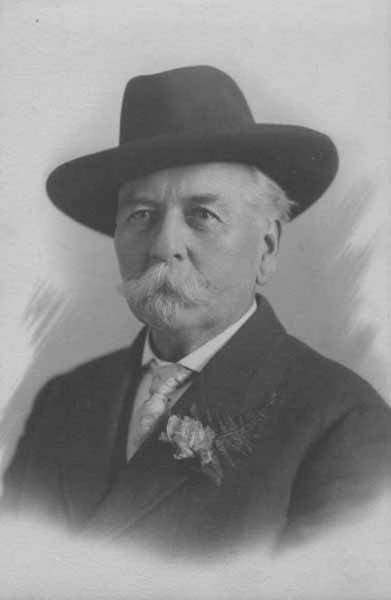
This street is named for Thomas Dickerson Mercer (1813–1898), who came to Seattle in 1853 and homesteaded 160 acres in what is now Lower Queen Anne, living at what is now Roy Street and Taylor Avenue N. He became a King County commissioner and probate judge, and named Lake Washington and Lake Union, whose Lushootseed names are x̌ačuʔ and xáx̌əʔčuʔ(‘lake’ and its diminutive, respectively). Mercer Island is named for him, as are three of its main streets, W Mercer Way, N Mercer Way, and E Mercer Way. Mercer Slough in Bellevue is named for his brother Aaron (1826-1902), and his brother Asa (1839–1917) is known for being the first instructor at, and first president of, the Territorial University of Washington (being the only college graduate in Seattle in 1861); and for bringing the “Mercer Girls” to Seattle to address the settlement’s severe gender imbalance (thereby inspiring the 1960s TV show Here Come the Brides).
Thomas Dickerson Mercer
Today, W Mercer Street begins at Elliott Avenue W and goes a block east to 6th Avenue W, where it becomes a stairway. At the top of the stairway, the street becomes a major arterial (connecting directly to Elliott via W Mercer Place) and goes 1⅔ miles east to Eastlake Avenue E and Lakeview Boulevard E, where it is blocked by Interstate 5. (It is, incidentally, laid out on the boundary between the donation land claims of Mercer and David Thomas Denny. Mercer’s claim is today bounded by Queen Anne Avenue N on the west, Lake Union on the east, Highland Drive on the north, and Mercer Street on the south.) Connecting Interbay, Lower Queen Anne, Seattle Center, State Route 99, South Lake Union, Interstate 5, and Capitol Hill, Mercer Street is a linchpin of Seattle’s transportation system — but not a beloved one, having earned the name “Mercer Mess” decades ago.
East of Interstate 5, E Mercer Street begins again at Melrose Avenue E and goes nearly 1½ miles to 28th Avenue E, interrupted only once, at 17th Avenue E, where it is pedestrian-only for half a block. Mercer resumes briefly at Dewey Place E but after a couple hundred feet becomes a stairway connecting to Lake Washington Boulevard E and 31st Avenue E. A block east of that, at 32nd Avenue E, E Mercer Street resumes as another stairway, and becomes a street again just west of 33rd Avenue E. This segment goes about ⅛ of a mile to 36th Avenue E. There is one final 200-foot-long segment of E Mercer Street east of 39th Avenue E. Platted into Lake Washington, this is a shoreline street end, but not, unfortunately, one open to the public. (It was this particular street end that first got me involved with Friends of Street Ends, as I grew up just ¼ of a mile up the hill.)
Born and raised in Seattle, Benjamin Donguk Lukoff had his interest in local history kindled at the age of six, when his father bought him settler granddaughter Sophie Frye Bass’s Pig-Tail Days in Old Seattle at the gift shop of the Museum of History and Industry. He studied English, Russian, and linguistics at the University of Washington, and went on to earn his master’s in English linguistics from University College London. His book of rephotography, Seattle Then and Now, was published in 2010. An updated version came out in 2015.
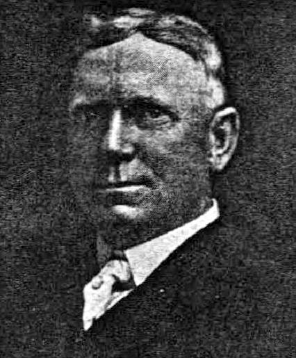
Dillis Ward, when a young man, did his part in building the old University for he drove a team that hauled stone and lime for the foundation. After the building was finished, he entered as a pupil into the first class. He taught school later on, and many an old-timer can recall the genial, kindly school teacher.
According to this biography, Ward, who came to Seattle in 1859, also had a hand in founding both The Post (a predecessor of the Seattle Post-Intelligencer) and The Seattle Daily Chronicle (a predecessor of The Seattle Times). However, his name does not appear in Professor Edmond S. Meany’s Newspapers of Washington Territory, in this article on the Post Building from the Pacific Coast Architecture Database, or in this HistoryLink article on the history of the P-I. All of them do mention brothers Kirk C. and Mark Ward, but Dillis’s entry at FamilySearch mentions no siblings, and Mark and Kirk’s entries do not mention Dillis. However, they do appear to have the same father, Jesse Ward. It looks as if Dillis was Jesse’s son from his first marriage, to Elizabeth Raley. As she died the same year Dillis was born, it may have been in childbirth. Kirk and Mark appear to be Jesse’s sons from his subsequent marriage to Exeline Cason. Exactly what part he may have played in the founding of the papers, and why this is missing from the articles above (and, incidentally, from Pig-Tail Days, which one would think might have mentioned this fact) is unclear.
Ward Street begins at Queen Anne Avenue N and goes ⅗ of a mile east to Aurora Avenue N. There is a short segment of E Ward Street on Capitol Hill between 14th Avenue E and 15th Avenue E, followed by another one, ⅓ of a mile long, from 23rd Avenue E and Turner Way E down the hill to 29th Avenue E and E Aloha Street, at the west end of Washington Park Playfield. There follows another one-block segment on the other side of the park, between 31st Avenue E and 32nd Avenue E, and a final segment from 34th Avenue E to 37th Avenue E.
Born and raised in Seattle, Benjamin Donguk Lukoff had his interest in local history kindled at the age of six, when his father bought him settler granddaughter Sophie Frye Bass’s Pig-Tail Days in Old Seattle at the gift shop of the Museum of History and Industry. He studied English, Russian, and linguistics at the University of Washington, and went on to earn his master’s in English linguistics from University College London. His book of rephotography, Seattle Then and Now, was published in 2010. An updated version came out in 2015.
Born and raised in Seattle, Benjamin Donguk Lukoff had his interest in local history kindled at the age of six, when his father bought him settler granddaughter Sophie Frye Bass’s Pig-Tail Days in Old Seattle at the gift shop of the Museum of History and Industry. He studied English, Russian, and linguistics at the University of Washington, and went on to earn his master’s in English linguistics from University College London. His book of rephotography, Seattle Then and Now, was published in 2010. An updated version came out in 2015.
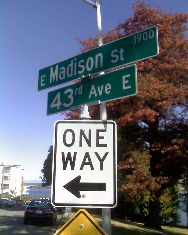
Madison Street — another of Seattle’s “first streets” — was named for James Madison, president of the United States from 1809 to 1817. It is the only street in town that stretches, uninterrupted, from the salt water of Elliott Bay and Puget Sound to the fresh water of Lake Washington.
Originating as the McGilvra Road in 1861, Madison Street begins on the Elliott Bay waterfront at Alaskan Way and ends 3¾ miles northeast of there at a small fishing pier, just east of 43rd Avenue E and north of Madison Park Beach. Apart from a slight bend to the northeast at 22nd Avenue, it is as straight as an arrow from beginning to end.
Born and raised in Seattle, Benjamin Donguk Lukoff had his interest in local history kindled at the age of six, when his father bought him settler granddaughter Sophie Frye Bass’s Pig-Tail Days in Old Seattle at the gift shop of the Museum of History and Industry. He studied English, Russian, and linguistics at the University of Washington, and went on to earn his master’s in English linguistics from University College London. His book of rephotography, Seattle Then and Now, was published in 2010. An updated version came out in 2015.
This short street in the Washington Park neighborhood runs just over a tenth of a mile from Lake Washington Boulevard E in the west to 36th Avenue E in the east, a block south of E Mercer Street.
The Pacific Coast Company rail, shipping and coal operations served the West Coast from the mid-19th century until its last railways were abandoned or sold in the mid-20th century. Though the company was organized under the Pacific Coast Company name in late 1897, it comprised several existing organizations, most notably the Pacific Coast Steamship Co., Pacific Coast Coal Co., and the Pacific Coast Railway. In Seattle, the Columbia & Puget Sound Railroad, originally the Seattle & Walla Walla, became part of the Pacific Coast Railway in 1916. The several operations of Pacific Coast Co., which also included a cement company and engineering company, played an important role in the development of King County resources and the development of Seattle and outlying communities.
Born and raised in Seattle, Benjamin Donguk Lukoff had his interest in local history kindled at the age of six, when his father bought him settler granddaughter Sophie Frye Bass’s Pig-Tail Days in Old Seattle at the gift shop of the Museum of History and Industry. He studied English, Russian, and linguistics at the University of Washington, and went on to earn his master’s in English linguistics from University College London. His book of rephotography, Seattle Then and Now, was published in 2010. An updated version came out in 2015.


.jpg)