Ohio Avenue S begins at Diagonal Avenue S and goes nearly ½ a mile south to E Marginal Way S and S Dawson Street. It resumes ⅛ of a mile south of there at E Marginal Way S and S Brandon Street and goes a further ⅓ of a mile south to S Fidalgo Street.
Born and raised in Seattle, Benjamin Donguk Lukoff had his interest in local history kindled at the age of six, when his father bought him settler granddaughter Sophie Frye Bass’s Pig-Tail Days in Old Seattle at the gift shop of the Museum of History and Industry. He studied English, Russian, and linguistics at the University of Washington, and went on to earn his master’s in English linguistics from University College London. His book of rephotography, Seattle Then and Now, was published in 2010. An updated version came out in 2015.
Born and raised in Seattle, Benjamin Donguk Lukoff had his interest in local history kindled at the age of six, when his father bought him settler granddaughter Sophie Frye Bass’s Pig-Tail Days in Old Seattle at the gift shop of the Museum of History and Industry. He studied English, Russian, and linguistics at the University of Washington, and went on to earn his master’s in English linguistics from University College London. His book of rephotography, Seattle Then and Now, was published in 2010. An updated version came out in 2015.
S Fidalgo Street begins at a shoreline street end on the Duwamish Waterway just west of Ohio Avenue S and goes 700 feet east to E Marginal Way S. It picks up again at 1st Avenue S and goes half a mile east, then southeast, to a dead end just east of Padilla Place S.
Born and raised in Seattle, Benjamin Donguk Lukoff had his interest in local history kindled at the age of six, when his father bought him settler granddaughter Sophie Frye Bass’s Pig-Tail Days in Old Seattle at the gift shop of the Museum of History and Industry. He studied English, Russian, and linguistics at the University of Washington, and went on to earn his master’s in English linguistics from University College London. His book of rephotography, Seattle Then and Now, was published in 2010. An updated version came out in 2015.
S Orcas Street begins at E Marginal Way S and goes ¾ of a mile east, then southeast, to Corson Avenue S, where it becomes S Doris Street. It picks up again east of Interstate 5 at 15th Avenue S and goes three blocks east to 18th Avenue S. Its longest and final stretch begins just west of 20th Avenue S and goes 2¼ miles east to Lake Washington Boulevard S just west of Seward Park.
Born and raised in Seattle, Benjamin Donguk Lukoff had his interest in local history kindled at the age of six, when his father bought him settler granddaughter Sophie Frye Bass’s Pig-Tail Days in Old Seattle at the gift shop of the Museum of History and Industry. He studied English, Russian, and linguistics at the University of Washington, and went on to earn his master’s in English linguistics from University College London. His book of rephotography, Seattle Then and Now, was published in 2010. An updated version came out in 2015.
Airport Way S does not, as one might expect, go from the city to Seattle–Tacoma International Airport (known to locals as Sea–Tac), but rather to King County International Airport (better known as Boeing Field). It got its current name in 1931 at the request of the Georgetown-South Seattle Improvement Club, which, according to an article in the April 12 issue of The Seattle Times,
…asked the City Council to merge portions of Seattle Boulevard, Eighth and Ninth Avenues South and Duwamish Avenue, leading from the central business area to Boeing Field, into a new highway, to be known as Airport Way.… [They contended] that strangers are confused in efforts to find the airport by lack of any specifically designated street leading to it.
The Beach or River Road… [which] skirted the shore of the bay at the foot of the high Beacon Hill bluff, east of what is now Airport Way, and ran south along the Duwamish.… Built in the early fifties, [it] was a hard road to keep in good condition.… In 1886, a road was built on piling over the mud flats a little west of the Beach Road to avoid the slides and floods. This street became known as the Grant Street Bridge.
Essentially, there were a series of roads following the semicircular curve of Elliott Bay from Downtown to the Duwamish River before the tideflats were filled in: first Beach Road (or River Road), then the Grant Street Bridge, which in turn became Seattle Boulevard once the fill was complete. Sometime before 1918… the portion of Seattle Boulevard that ran northeast–southwest (the southern third of the semicircle) was renamed Diagonal Avenue. (In 1931, the rest of Seattle Boulevard was renamed Airport Way.)
This photograph, taken circa 1900 by Anders Beer Wilse, looks northwest from Beacon Hill over the Grant Street Bridge and the Elliott Bay tideflats. At upper left is West Seattle; at upper right is Magnolia. From this perspective, Downtown Seattle appears just below Magnolia. Bainbridge Island is in the distance across Puget Sound.
Once Sea–Tac fully opened in 1949, Airport Way S no longer led to the region’s primary airport, which was more directly reached via U.S. 99, but no further name changes took place.
Today, Airport Way S begins at Seattle Boulevard S and 6th Avenue S and goes 6⅗ miles southeast, then south, then southeast again, ending at Boeing Access Road. Its lower 2½ miles parallel the eastern boundary of Boeing Field.
Born and raised in Seattle, Benjamin Donguk Lukoff had his interest in local history kindled at the age of six, when his father bought him settler granddaughter Sophie Frye Bass’s Pig-Tail Days in Old Seattle at the gift shop of the Museum of History and Industry. He studied English, Russian, and linguistics at the University of Washington, and went on to earn his master’s in English linguistics from University College London. His book of rephotography, Seattle Then and Now, was published in 2010. An updated version came out in 2015.
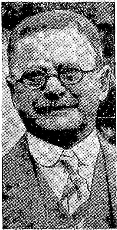
Born Giovanni Domenicio Corgiat in Italy, John was a real estate investor who, according to his Seattle Times obituary, was also notable for “establish[ing] the Louvre Restaurant, the first French-Italian eating place in Seattle, in 1888.” (It was destroyed the next year in the Great Seattle Fire.) He was also apparently involved in a number of legal cases relating to the explusion of restaurateur John Cicoria from the Joseph Mazzini Society in 1907: not only the lawsuit demanding Cicoria’s reinstatement in the Italian-American fraternal organization, but one in which the society succeeded in making him pay its legal fees, and three libel suits — one which Cicoria won against Corgiat, and two which Corgiat filed against The Seattle Times and the Message-Vero-Italo-Americano with Cicoria as co-defendant in each. The suit against the Times was dismissed at Corgiat’s request; I haven’t been able to find any more information about the other.
John Corgiat, from his obituary in the Seattle Times, December 10, 1936
Originally Corgiat Street, S Corgiat Drive begins at the railroad tracks just east of Airport Way S and goes 300 feet northeast to just past Ursula Place S, at which point it turns northwest and becomes S Corgiat Drive (not in the original plat). From there, it goes ⅖ of a mile to S Albro Place, just west of Interstate 5.
Born and raised in Seattle, Benjamin Donguk Lukoff had his interest in local history kindled at the age of six, when his father bought him settler granddaughter Sophie Frye Bass’s Pig-Tail Days in Old Seattle at the gift shop of the Museum of History and Industry. He studied English, Russian, and linguistics at the University of Washington, and went on to earn his master’s in English linguistics from University College London. His book of rephotography, Seattle Then and Now, was published in 2010. An updated version came out in 2015.
In the late 1850s, the federal government began construction on a road connecting Fort Steilacoom in Pierce County to Fort Bellingham in Whatcom County. By the end of the decade, the military road had been finished (just in time for Fort Bellingham to close). The route it took through Seattle included what are now Beacon Avenue S, 1st Avenue, Dexter Avenue N, Westlake Avenue N, and Fremont Avenue N, among other streets. South of Seattle, much of the road still exists with its original name, but within the city limits, only a bit of Military Road S remains:
A 750-foot-long stretch between Beacon Avenue S at 27th Avenue S and Van Asselt Elementary School south of S Myrtle Street
A ½-mile-long stretch between S Othello Street just south of the school to the Union Pacific railroad tracks east of Airport Way S, just west of Interstate 5
Born and raised in Seattle, Benjamin Donguk Lukoff had his interest in local history kindled at the age of six, when his father bought him settler granddaughter Sophie Frye Bass’s Pig-Tail Days in Old Seattle at the gift shop of the Museum of History and Industry. He studied English, Russian, and linguistics at the University of Washington, and went on to earn his master’s in English linguistics from University College London. His book of rephotography, Seattle Then and Now, was published in 2010. An updated version came out in 2015.
This street was named for Walter Graham (1828–1919), who came to Seattle in 1853. Three years later, he married Eliza Mercer, second daughter of Thomas Mercer (Mercer Street, Mercer Island), though she unfortunately died six years later. With his third wife, Elizabeth Crammond (or Crommon), he had a daughter, Nellie, who later married David Thomas Denny II, son of early settler David Thomas Denny (Denny Way). Graham’s brother, David, came to Seattle four years after his brother, and was one of the city’s first schoolteachers. He ended up marrying Eliza Mercer’s sister, Susannah.
Graham sold some of his southeast Seattle land in 1865 to Everett Smith, who filed the plat of Brighton Beach in 1890 on which what was then Graham Avenue appeared. He once owned what is today Seward Park on Bailey Peninsula, which was previously known as Graham’s Peninsula.
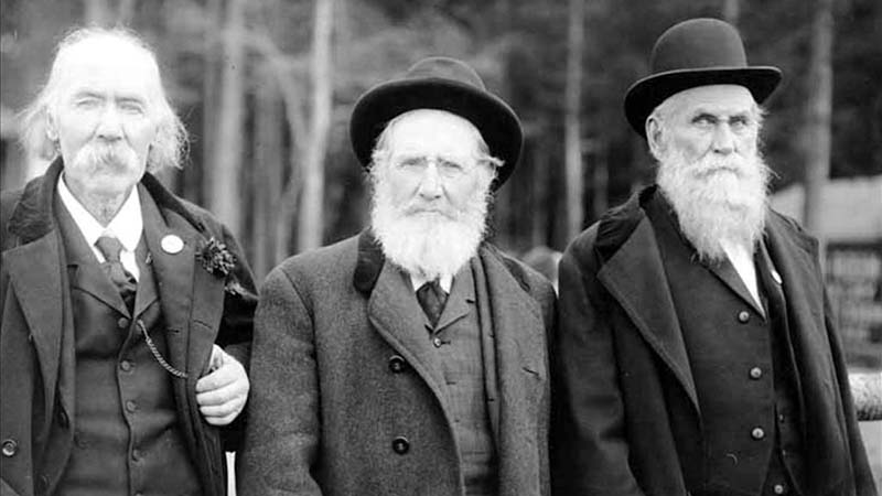
He was present at the Battle of Seattle in 1856, and is pictured below with fellow survivors Ira Woodin and Carson D. Boren (Boren Avenue).
Ira Woodin, Carson Boren, and Walter Graham at Alki Point, November 3, 1905
S Graham Street begins in the east at Wilson Avenue S and goes 2⅒ miles west to Swift Avenue S and 20th Avenue S, just east of Interstate 5. After a short segment between Corgiat Drive S and 16th Avenue S just west of the freeway, it next appears in West Seattle. Betwen 16th Avenue SW and 22nd Avenue SW, it alternates between roadway, stairway, and pathway, and there is a similar situation between 25th Avenue SW at Delridge Way SW and High Point Drive SW at Bataan Park. SW Graham Street begins again at High Point Drive SW and SW Raymond Street and goes 1¼ miles to its end at 50th Avenue SW,
Born and raised in Seattle, Benjamin Donguk Lukoff had his interest in local history kindled at the age of six, when his father bought him settler granddaughter Sophie Frye Bass’s Pig-Tail Days in Old Seattle at the gift shop of the Museum of History and Industry. He studied English, Russian, and linguistics at the University of Washington, and went on to earn his master’s in English linguistics from University College London. His book of rephotography, Seattle Then and Now, was published in 2010. An updated version came out in 2015.
E Marginal Way S and its twin across the Duwamish Waterway, W Marginal Way SW, are good examples of purely descriptive Seattle street names. In fact, they are first mentioned in the press as adjective + noun, not name + type:
“Marginal ways are urged for both sides of Duwamish waterway.” Seattle Post-Intelligencer, October 27, 1911, in reference to the Bogue Plan
“Coincident with the completion of the Duwamish waterway and the wide marginal streets on each side, a publicly owned railway should be built along these marginal ways…” C.C. Closson, realtor and the Port of Seattle’s first paid employee, in a letter to the editor, Seattle P-I, July 8, 1912
“East and west marginal ways, planned by Bogue to parallel the waterway to give railroads, street cars and other transportation facilities access to the Duwamish waterway, will both pass through Oxbow.“ The Seattle Times, March 26, 1914
“Marginal ways parallel the new waterway for the whole distance, connecting with the main streets of the city running to the south.” Seattle P-I, August 13, 1914
A longer excerpt, from an article in the April 19, 1914, issue of The Seattle Times, explains the reason for their creation:
Second only in importance to the waterway are the projected traffic streets, east and west marginal ways, laid out on both sides of the waterway about 1,000 feet back to give railways and street car lines the opportunity to parallel the waterway on both sides for its entire length, to give service to the industries locating along the waterway. As an allowance of $175,000 was made for East Marginal Way in the $3,000,000 county bond issue for roads, that street is now being condemned by the city and will be constructed 130 feet wide to the south city limits, where it will join a county road. West Marginal Way is also being promoted by interested property owners. As the existing railways are already but a short distance east of the Duwamish River, spurs can be thrown into East Marginal Way at slight expense. Also the port commission is considering a plan for port district terminal tracks on the Marginal Ways to serve the waterway.
The Duwamish Waterway, whose construction began on October 14, 1913, was a straightening and deepening of the last 6 miles of the formerly meandering river. Construction of the waterway, with Harbor Island at its mouth (the largest artificial island in the world from 1909 to 1938), plus the filling of the Elliott Bay tidelands, are what give Seattle’s harbor its modern shape.
Plan of the Duwamish Waterway, from the August 31, 1913, issue of the Seattle Post-Intelligencer, page 44
E Marginal Way S begins as an extension of Alaskan Way S — originally Railroad Avenue, which served much the same function for the central waterfront — at the Port of Seattle’s Terminal 30, and stretches 4⅖ miles from there to the southern city limits. (From the southern end of the Alaskan Freeway to the northern end of the 1st Avenue South Bridge, it carries Washington State Route 99.) Beyond there it runs 3½ miles more to S 133rd Street in Tukwila.
Born and raised in Seattle, Benjamin Donguk Lukoff had his interest in local history kindled at the age of six, when his father bought him settler granddaughter Sophie Frye Bass’s Pig-Tail Days in Old Seattle at the gift shop of the Museum of History and Industry. He studied English, Russian, and linguistics at the University of Washington, and went on to earn his master’s in English linguistics from University College London. His book of rephotography, Seattle Then and Now, was published in 2010. An updated version came out in 2015.
S River Street is just ½ a mile long, and none of it parallels the Duwamish River. The reason behind this is the same reason S Front Street is perpendicular to the waterway — the rechanneling of the Duwamish River that began in 1913. In Joseph R. McLaughlin’s Water Front Addition to the City of Seattle, filed in 1906, Front Street had a horseshoe shape. North Front Street is today’s Front Street, and South Front Street was changed to River Street in 1907, when West Seattle was annexed to Seattle. The Baist Atlas depiction of the Oxbow, below left, is from 1912, so has the modern name.
Today’s S River Street begins at 7th Avenue S and goes ½ a mile west, ending at 1st Avenue S, below the 1st Avenue S Bridge.
Born and raised in Seattle, Benjamin Donguk Lukoff had his interest in local history kindled at the age of six, when his father bought him settler granddaughter Sophie Frye Bass’s Pig-Tail Days in Old Seattle at the gift shop of the Museum of History and Industry. He studied English, Russian, and linguistics at the University of Washington, and went on to earn his master’s in English linguistics from University College London. His book of rephotography, Seattle Then and Now, was published in 2010. An updated version came out in 2015.
Usually, a Front Street designates a city’s waterfront. Front Street in Philadelphia parallels the Delaware River; NW Front Avenue in Portland, Oregon, goes up the Willamette River; Front Street in Toronto runs along Lake Ontario. Seattle once had a prominent Front Street alongside Elliott Bay, but it was renamed 1st Avenue in 1895. The Front Street we do have runs a grand total of ⅖ of a mile split among three segments, and it runs east–west, while the nearby Duwamish River runs north–south. Why is this?
As it turns out, S Front Street — established as part of Joseph R. McLaughlin’s Water Front Addition to the City of Seattle in 1906 — did use to run along the river, before it was rechanneled beginning in 1913. (Here is an excellent post from the Burke Museum on the Duwamish meanders, with some great maps and aerials.) The maps below show its course along the Duwamish River Oxbow in 1912 (left) and its current landlocked state (right). You can still make out its former location, as well as small remnants in the form of the Slip 2 and Slip 3 inlets. (Incidentally, Front Street originally was shaped like a horseshoe — today’s S Front Street was originally North Front Street, and South Front Street is today S River Street.)
Speaking of the Oxbow, here’s an advertisement for it. So much for that “16,000 feet of deep water frontage.”
Advertisement for Oxbow in June 1, 1906, issue of The Seattle Times
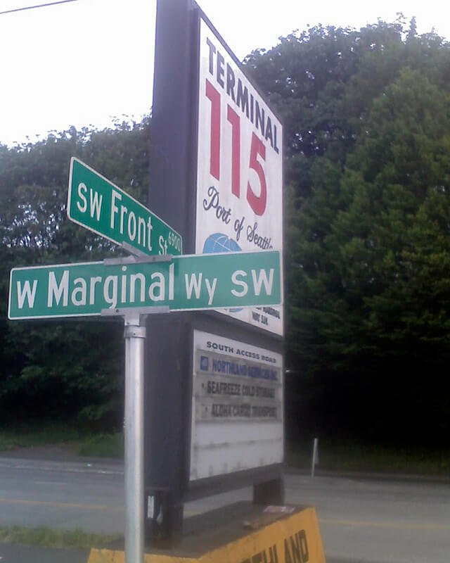
Today’s S Front Street begins at 6th Avenue S and goes ¼ of a mile west, ending just beyond 4th Avenue S. There is another 400-foot-long section between E Marginal Way S and 1st Avenue S, below the approach to the 1st Avenue S Bridge. And then there is one last 200-foot-long section on the west side of the Duwamish River — SW Front Street starts at W Marginal Way SW and ends at the entrance to the Port of Seattle’s Terminal 115 (which used to be Boeing Plant 1, the airplane manufacturer’s first production facility).
Incidentally, here’s a great article on the one in New Orleans I came across while looking up various Front Streets. It’s hard to beat a lede like this: “In a city replete with famed streets, scenic avenues and poetic street names, one particular artery excels at being obscure, nominally insipid, marvelously intermittent, and sometimes barely even a street.”
Born and raised in Seattle, Benjamin Donguk Lukoff had his interest in local history kindled at the age of six, when his father bought him settler granddaughter Sophie Frye Bass’s Pig-Tail Days in Old Seattle at the gift shop of the Museum of History and Industry. He studied English, Russian, and linguistics at the University of Washington, and went on to earn his master’s in English linguistics from University College London. His book of rephotography, Seattle Then and Now, was published in 2010. An updated version came out in 2015.
* As a card-carrying address nerd, I feel compelled to mention that the driveway for the Nippon Kan Theatre/Kobe Park Building at the dead end of S Washington Street is, technically, the northernmost segment of Maynard Avenue S, at least for its first hundred feet.
David Swinson Maynard, ca 1868, photographer unknown
Maynard — unlike Republican Arthur Armstrong Denny, who platted the tract to the north — was a Democrat, and named a number of streets in his plat after prominent Democratic politicians, including the slaveholders President Andrew Jackson and Vice President William Rufus DeVane King; Oregon Territorial Governor Joseph Lane, who went on to be the pro-slavery Southern Democratic candidate for vice president in 1860; and pro-slavery California Senator John B. Weller. I haven’t seen much online about Maynard’s personal racial views, but he was known to have had good relations (given the era) with the local Native Americans, at least. Junius Rochester writes for HistoryLink:
Perhaps one of Doc Maynard’s most enduring qualities, besides his amiability, was his high regard for the local Indians. Chief Seattle was a particular friend, having stated: “My heart is very good toward Dr. Maynard.” Maynard, who knew tribulations in his own life, understood that besides the tools, medicines, guns, and other wonders that the white men had brought to Puget Sound, they also introduced disease, intolerant religions, and the inhospitable idea of private property.
There can be no avoiding his privileged promotion of white settlers at Native Americans’ expense. “They will fight,” he writes on Nov. 4, 1855. “There is no reason why they (sho)uld not, but we must conquer them.”
One hopes that, if Maynard were alive today, he would choose worthier men (and women) to honor than Jackson, King, Lane, and Weller.
Born and raised in Seattle, Benjamin Donguk Lukoff had his interest in local history kindled at the age of six, when his father bought him settler granddaughter Sophie Frye Bass’s Pig-Tail Days in Old Seattle at the gift shop of the Museum of History and Industry. He studied English, Russian, and linguistics at the University of Washington, and went on to earn his master’s in English linguistics from University College London. His book of rephotography, Seattle Then and Now, was published in 2010. An updated version came out in 2015.
This street, which runs not quite a tenth of a mile from Ellis Avenue S in the west to 13th Avenue S in the east, was named by Angelo Boitano after himself as part of Boitano’s Supplemental Addition to the City of Georgetown in 1906. (Incidentally, if I ever had the opportunity to name a street after myself, I would call it Lukoff, not Benjamin.)
There isn’t much on the internet about him, but apparently he was interested in chestnut growing, and was in a bad buggy accident in 1908.
July 19, 1908 article in The Seattle Times on buggy accident that injured Boitano
Born and raised in Seattle, Benjamin Donguk Lukoff had his interest in local history kindled at the age of six, when his father bought him settler granddaughter Sophie Frye Bass’s Pig-Tail Days in Old Seattle at the gift shop of the Museum of History and Industry. He studied English, Russian, and linguistics at the University of Washington, and went on to earn his master’s in English linguistics from University College London. His book of rephotography, Seattle Then and Now, was published in 2010. An updated version came out in 2015.
This short street — just over 300 feet long — runs from Airport Way S in the east to Corson Avenue S in the west. It was established in 1903 as Carstens Street, part of Carstens’ Addition to Georgetown, “filed for record at the request of Thomas Carstens on the 4[th] day of June 1903 at 49 Min. past 9 A.M.” This is the first time I’ve seen the actual time of filing on a plat!
Thomas Carstens, born in 1865 in Husum, Germany, near Denmark, came to the Pacific Northwest in 1884, and in 1890 established a butcher shop with his brother, Ernest, which later grew into the Carstens Packing Company.
Clinton A. Snowden, author of History of Washington: The Rise and Progress of an American State, wrote in 1911 of Carstens:
Mr. Carstens, besides being president of the Carstens Packing Company, is president of the Tacoma Wheat Land Company, president of the Pacific Oil Mills, and director of the National Realty Company of Tacoma. He is a member of the Seattle Chamber of Commerce, Seattle Commercial Club, Arctic Club of Seattle, Seattle Manufacturers’ Association, Duwamish River Improvement Club, Tacoma Commercial Club, and Tacoma Chamber of Commerce.
Born and raised in Seattle, Benjamin Donguk Lukoff had his interest in local history kindled at the age of six, when his father bought him settler granddaughter Sophie Frye Bass’s Pig-Tail Days in Old Seattle at the gift shop of the Museum of History and Industry. He studied English, Russian, and linguistics at the University of Washington, and went on to earn his master’s in English linguistics from University College London. His book of rephotography, Seattle Then and Now, was published in 2010. An updated version came out in 2015.
Occidental Avenue S, which begins at Yesler Way in Pioneer Square, is one of those Seattle streets whose names extend into the suburbs. It makes its southernmost appearance at S 197th Street in Des Moines.
It received its name in 1895 as part of the Great Renaming — it had originally been S Second Street. It once had a partner, Oriental Avenue, to the east (originally S Fourth Street), which is today 3rd Avenue S. “Oriental,” of course, means “Eastern,” as “Occidental” means “Western.” (I haven’t been able to determine just when Oriental Avenue became 3rd, but it was last mentioned in The Seattle Times on October 17, 1920.)
And why this particular pairing? The Occidental Hotel, which once overlooked the beginning of Occidental Avenue, is almost certainly the reason, but it’s not spelled out in the ordinance.
Born and raised in Seattle, Benjamin Donguk Lukoff had his interest in local history kindled at the age of six, when his father bought him settler granddaughter Sophie Frye Bass’s Pig-Tail Days in Old Seattle at the gift shop of the Museum of History and Industry. He studied English, Russian, and linguistics at the University of Washington, and went on to earn his master’s in English linguistics from University College London. His book of rephotography, Seattle Then and Now, was published in 2010. An updated version came out in 2015.


