Thorndyke Avenue W

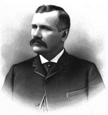
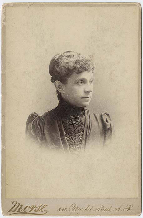
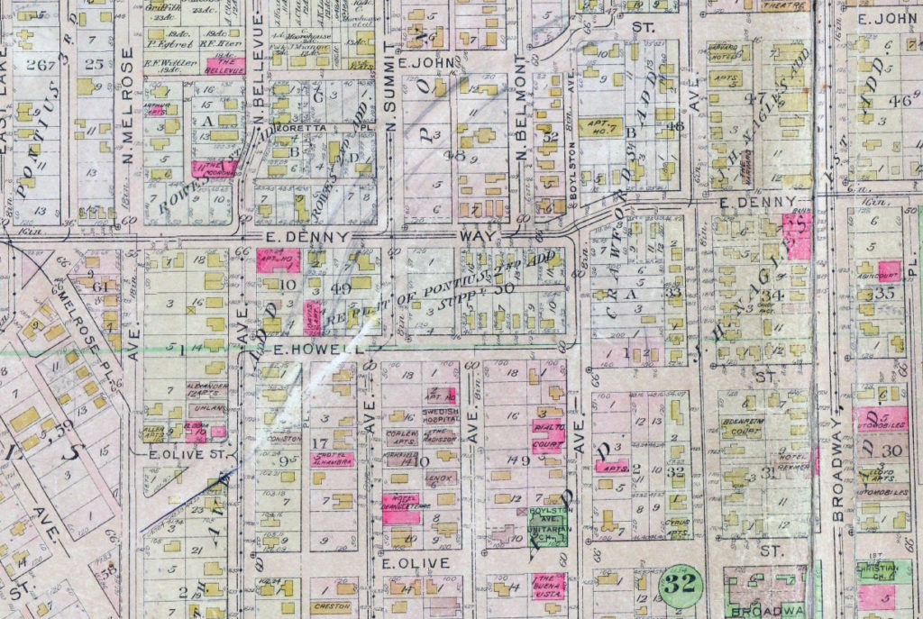
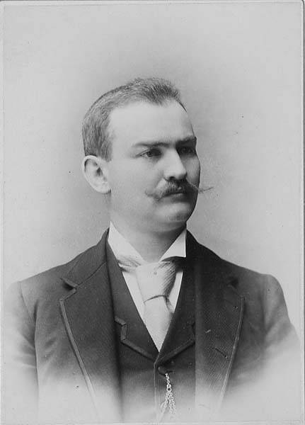
This street was named for Grace Chalmers Thorndike (, who married Daniel Hunt Gilman (Gilman Avenue W) in 1888. It was created in 1890 as part of Gilman’s Addition to the City of Seattle. The original plan was that Gilman and Thorndyke Avenues would intersect each other at Grand Boulevard (now W Dravus Street), but this was changed, as can be seen in the plat map below, likely in the knowledge that the tracks of the Seattle, Lake Shore and Eastern Railway would soon multiply and make that impractical.

Gilman's Addition to Seattle, 1890, two sheets stitched together
Gilman’s Addition to Seattle, 1890

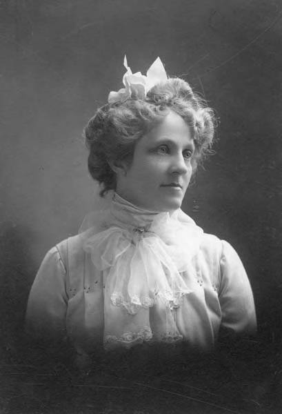
It’s not entirely clear why the street is named Thorndyke rather than Thorndike. There was an announcement of the Gilman–Thorndike wedding in the January 15, 1888, issue of the Seattle Post-Intelligencer that spelled the name with a y, but otherwise the family’s name routinely appears in the Seattle press with an i. Yet we see that Grace’s sister Minnie — wife of James Bothwell (W Bothwell Street) — spelled her name with a y (at any rate, that is what appears on her tombstone).

(It’s also worth noting that Grace’s sister Estella married Captain William Rankin Ballard, after which the Ballard neighborhood is named, and her sister Delia married Ballard’s business partner Captain John Ayres Hatfield. The Thorndikes’ father was himself a ship’s captain, one Ebenezer Augustus Thorndike.)

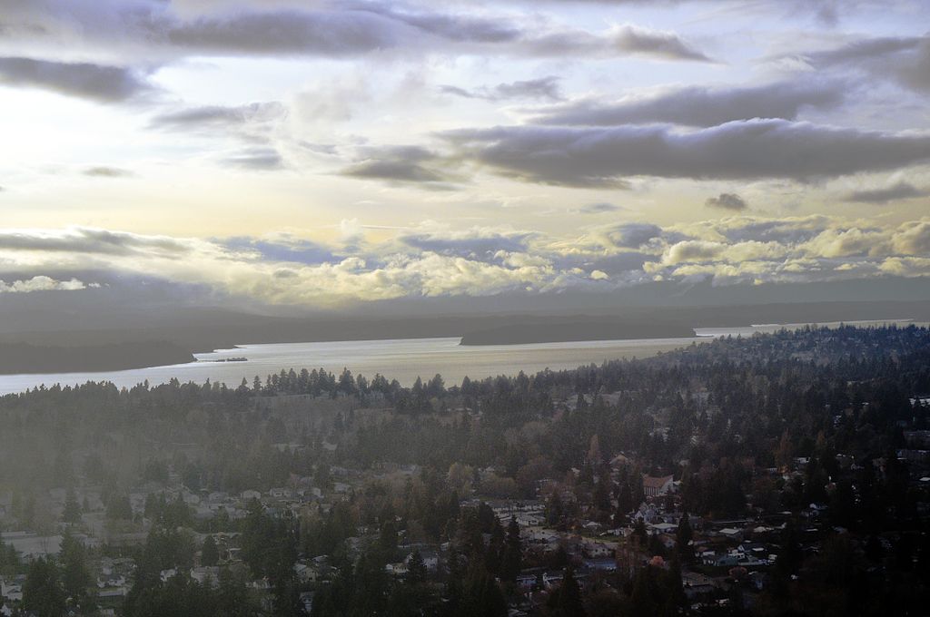
Today, Thorndyke Avenue W begins at W Galer Street, at the west end of the Magnolia Bridge, and goes just over a mile northwest to 20th Avenue W and W Barrett Street. It picks up again as a minor road on the other side of the BNSF Railway tracks, going about ⅕ of a mile northwest from 17th Avenue W and W Bertona Street to a dead end under the 15th/Emerson/Nickerson overpass at the south end of the Ballard Bridge.

Gilman Avenue W

This street was named for Daniel Hunt Gilman (1845–1913), who among other things was one of the founders of the Seattle, Lake Shore and Eastern Railway (SLS&E) in 1885. The SLS&E is now part of the BNSF Railway, and its old right-of-way along the Lake Washington Ship Canal and Lake Washington is now the Burke–Gilman Trail.

Daniel Hunt Gilman, circa 1890

The street was created in 1890 as part of Gilman’s Addition to the City of Seattle by Dr. Henry A. Smith (Smith Cove) and Franklin M. Jones and his wife, Carrie B. Jones. Franklin was a member of the New York banking firm Jameson, Smith and Cotting, financiers of Gilman’s business ventures.

Today, Gilman Avenue W begins at 20th Avenue W and W Bertona Street and goes ⁹⁄₁₀ of a mile northwest to 28th Place W, where it becomes W Government Way. The right-of-way continues on from there, though, and there is a 120-foot-long segment between 32nd Avenue W and Gay Avenue W and then, on the other side of Kiwanis Memorial Preserve Park, another 120-foot-long segment at the end of 34th Avenue W.

Originally, Gilman Avenue W existed east of the railroad tracks as well, but that section, between 15th Avenue W and 11th Avenue W, was changed to Gilman Drive W in 1961.

Gilman's Addition to Seattle, 1890, two sheets stitched together
Gilman’s Addition to Seattle, 1890

W Grover Street

This Magnolia street, like W Tilden Street, was named by Dr. Francis G. Bryant as part of the 1877 Bay View Addition to the City of Seattle. As I noted in the Tilden Street article, he named his streets for prominent Democratic politicians of the era. Only Tilden and Grover remain. It would appear that the Grover in question was La Fayette Grover, governor of Oregon from 1870 to 1877 and senator from Oregon from 1877 to 1883.

As Wikipedia notes, “During the [disputed] 1876 presidential election, Oregon’s statewide result clearly favored Rutherford Hayes, but then-governor Grover claimed that elector John Watts was constitutionally ineligible to vote since he was an ‘elected or appointed official’. Grover substituted a Democratic elector in his place. The two Republican electors dismissed Grover’s action and each reported three votes for Hayes, while the Democratic elector, C. A. Cronin, reported one vote for Samuel Tilden and two votes for Hayes. The vote was critical because the electoral college without John Watts’s vote was tied 184–184.”

As it turns out, the election was ultimately awarded to Hayes as part of the Compromise of 1877, but it appears Governor Grover did his best to help his fellow Democrat. (There’s more about Oregon’s pivotal role in the Wilamette Week article “That One Time Oregon Decided the Presidential Election.”)

W Grover Street begins at 28th Avenue W at the entrance to Magnolia Manor Park, and runs a tenth of a mile west to 30th Avenue W. It then runs one more block from 31st Avenue W to 32nd Avenue W.

W Tilden Street

This Magnolia street was named by Dr. Francis G. Bryant as part of the 1877 Bay View Addition to the City of Seattle for Samuel J. Tilden, governor of New York from 1875 to 1876 and Democratic candidate for president in the election of 1876. The Compromise of 1877, according to Wikipedia, “resulted in the United States federal government pulling the last troops out of the South, and ending the Reconstruction Era. Through the Compromise, Republican Rutherford B. Hayes was awarded the White House over Democrat Samuel J. Tilden on the understanding that Hayes would remove the federal troops whose support was essential for the survival of Republican state governments in South Carolina, Florida and Louisiana.” The plat was filed on February 17 — while the Electoral Commission was in session and had not yet awarded the election to Hayes.

Of the other named streets in the Bay View Addition, only Grover remains, but most of them appear to be named for prominent Democratic politicians of the era (Jackson excepted, as he died 32 years earlier). I left off the two I could not associate with anyone (Randall, Nichols) and am not as sure about Williams as I am about the others:

As for Dr. Bryant, I was unable to find out much about him other than he was some sort of doctor and filed a patent in 1877 for a new type of fire escape.

W Tilden Street begins at 28th Avenue W and goes just about 1,000 feet west to 31st Avenue W, its last hundred feet being a footpath through the landscaped right-of-way. On the other side of the valley, there is a 225-foot-long segment from 37th Avenue W to 38th Avenue W.

Lenora Street

This street is named for Margaret Lenora Denny (1847–1915), daughter of Arthur Armstrong Denny and Mary Ann Boren Denny. She, like Virginia Bell (namesake of Virginia Street) was just four years old when her family, as part of the Denny Party, settled at Alki Point in 1851. She was killed in a car crash that also took the life of Thomas W. Prosch (Prosch Avenue W); his wife, Virginia; and artist Harriet Foster Beecher.

Margaret Lenora Denny, circa 1900

Established as part of A.A. Denny’s 6th Addition to the City of Seattle in 1873, it begins at Alaskan Way as an (temporarily closed as of this writing) elevator and pedestrian bridge over the BNSF Railway tracks. The street proper begins just west of where Elliott Avenue ends at Western Avenue. From there it is just shy of ¾ of a mile to its end at Denny Way and Boren Avenue.

Note added October 10, 2023: Lenora Street now begins a block further to the southeast, at Elliott Way.

Virginia Street

This street is named for Mary Virginia Bell Hall (1847–1931), daughter of William Nathaniel Bell and Sarah Ann Peter Bell. Belltown and Bell Street were named for her father, Olive Way for her sister, and Stewart Street for her brother-in-law. She was just four years old when her family, as part of the Denny Party, settled at Alki Point in 1851.

Virginia Bell Hall, circa 1875
Virginia Bell, circa 1875

Established as part of the Plat of an Addition to the Town of Seattle, Washington Territory, Laid Off by the Heirs of Sarah A. Bell, Deceased in 1872, it begins at Western Avenue by Steinbrueck Park, at the northwest end of Pike Place Market, and goes ¾ of a mile northeast to Minor Avenue and Denny Way.


Stewart Street

This street is named for Joseph Stewart (1830–1889), husband of Olive Julia Bell Stewart (Olive Way). It was established in 1872 as part of the Plat of an Addition to the Town of Seattle, Washington Territory, Laid Off by the Heirs of Sarah A. Bell, Deceased.

Stewart Street begins at Pike Place and ends ⁹⁄₁₀ of a mile to the northwest at Eastlake Avenue E and John Street.

Olive Way

This street is named for Olive Julia Bell Stewart (1846–1921), daughter of William Nathaniel Bell and Sarah Ann Peter Bell. Belltown and Bell Street were named for her father, Virginia Street for her sister, and Stewart Street for her husband, Joseph. She was one of the younger members of the Denny Party, being five years old when they initially settled at Alki Point in 1851.

Olive Julia Bell Stewart, circa 1860
Olive Bell, circa 1860

Originally called Olive Street in the Plat of an Addition to the Town of Seattle, Washington Territory, Laid Off by the Heirs of Sarah A. Bell, Deceased in 1872, it begins at Stewart Street just east of 3rd Avenue and goes one mile northeast, then east, to Broadway E and E John Street.

On September 3, 1920, The Seattle Times reported that:

Extension of Olive Street, by the establishment of a diagonal thoroughfare to be known as Olive Way, running from the intersection of Olive Street in a northeasterly direction to Boylston Avenue North and East Denny Way, is provided in an ordinance completed yesterday afternoon by the city engineer’s office…. The purpose of the whole improvement is to afford an east and west arterial highway, leading from the business district into the residence section of the city, supplementary to Pike Street and Pine Street.

According to the Seattle Post-Intelligencer’s June 24, 1923, issue, it “formally opened to traffic yesterday… a public improvement for which a fight extending over a period of fifteen years was waged,” so this 1920 ordinance was certainly not the first time an improved connection between Downtown and Capitol Hill was proposed. I’m not entirely sure what happened in 1908 the writer might have been referring to, but perhaps it was the Bogue Plan and he was off by a few years?

Route of Olive Way drawn on 1912 Baist Atlas plate of Capitol Hill
Portion of plate 7, Baist’s Real Estate Atlas of Seattle (1912), planned route of E Olive Way drawn in pencil. The portion of E Olive Street between Melrose and Bellevue Avenues is now E Olive Place.

It appears from the 1921 ordinance establishing the extension that the Olive Way name was originally only applied to the street east of Bellevue Avenue; it wasn’t until 1926 that it was extended west to the street’s origin.

One curiosity about E Olive Way addresses: the block numbers are out of sync with other east–west streets in the area. For example, the block east of Melrose Avenue is the 300 block, east of Bellevue Avenue the 400 block, east of Summit 500, east of Belmont 600, east of Boylston 700, etc. — for other streets. For E Olive Way, east of Melrose is 1300, east of Bellevue 1400 and 1500, east of Summit and Belmont 1600, east of Boylston 1700, etc. — essentially continuing on from Downtown, not starting over at what is now the route of Interstate 5, as the other streets do. 

Vashon Place SW

This street — just about 350 feet long, like its neighbor Blake Place SW — connects SW Othello Street to Fauntleroy Way SW just north of Solstice Park. Created as part of the Lincoln Home Addition in 1907 by builder Albert Eugene Felmley and his wife, Mabel L. Felmley, it is named after Vashon Island, located 4 miles to the southwest, across Puget Sound. The island itself was named for Royal Navy Admiral James Vashon by his friend, Royal Navy Captain George Vancouver, in 1792.

Two other streets in the Lincoln Home Addition are named for Puget Sound islands: the already-mentioned Blake Place SW, and Bainbridge Place SW.

Aerial view of Vashon Island from the northwest
Aerial view of Vashon and Maury Islands from the northwest. Photograph by Flickr user Travis, licensed under Creative Commons Attribution-NonCommercial 2.0 Generic

Blake Place SW

This 350-foot-long street connects SW Othello Street to SW Fontanelle Street just north of Solstice Park. It was created as part of the Lincoln Home Addition in 1907 by builder Albert Eugene Felmley and his wife, Mabel L. Felmley, and is named after Blake Island, located 4⅖ miles to the west, across Puget Sound. The island itself was named for U.S. Navy Commodore George Smith Blake, then head of the United States Coast Survey, by Charles Wilkes in 1841.

Two other streets in the Lincoln Home Addition are named for Puget Sound islands: Bainbridge Place SW and Vashon Place SW.

Aerial view of Blake Island from the east
Aerial view of Blake Island from the east (West Seattle in foreground). Photograph by Joe Mabel, Wikimedia Commons, licensed under Creative Commons Attribution-Share Alike 3.0 Unported

Bainbridge Place SW

This short street — not quite 275 feet long — connects SW Othello Street to Fauntleroy Way SW just north of Lincoln and Solstice Parks. Created as part of the Lincoln Home Addition in 1907 by builder Albert Eugene Felmley and his wife, Mabel L. Felmley, it is named after Bainbridge Island, located 5¼ miles to the northwest, across Puget Sound. The island itself was named for U.S. Navy Commodore William Bainbridge, commander of the USS Constitution, by Charles Wilkes in 1841.

Two other streets in the Lincoln Home Addition are named for Puget Sound islands: Blake Place SW and Vashon Place SW.


Aerial view of Bainbridge Island from the southeast
Aerial view of Bainbridge Island from the southeast. Photograph by Dicklyon, Wikimedia Commons, licensed under Creative Commons Attribution-Share Alike 4.0 International

Pike Street

Pike Street first appears in the Plat of an Addition to the Town of Seattle as Laid Out by Arthur A. Denny, filed on April 5, 1869. It was named by Denny for John Henry Pike (1814–1903), best known for being the architect and builder of the original Territorial University of Washington in 1861. This article by Rob Ketcherside is the most comprehensive information available online about Pike. “Early Pikes in Seattle,” by Stuart Pike, is also worth a read. (Also of note: Pike’s son, Harvey Lake Pike [1842–1897], was the first person to try to connect Lake Washington’s Union Bay to Lake Union’s Portage Bay by a canal. This was unsuccessful, but he did end up platting the land in 1869 as Union City. His E North Street [north of the proposed canal] survives to this day.)

John Pike, from his obituary in the November 22, 1903, issue of The Seattle Times

In the original plat, Pike Street (as well as Union and Pine Streets) begins at Front Street — today’s 1st Avenue — but today it begins on the Elliott Bay waterfront at Alaskan Way as the Pike Street Hillclimb. Pike Street proper begins at Pike Place (home of the eponymous market) and Post Alley (underneath the Market Theater sign), both shown below, and makes it a full 1⅔ miles to just past 18th Avenue in the Central District before being interrupted. It then resurfaces at 23rd Avenue and goes another ⅘ of a mile to Grand Avenue in Madrona, a few blocks east of Lake Washington.

Pike Place Market entrance, corner of Pike Street and Pike Place, 2012
Pike Place Market entrance, corner of Pike Street and Pike Place, 2012. Photograph by kissmykumbaya, Wikimedia Commons (public domain)

S Fontanelle Street

This fragmented street starts at Rainier Avenue S and travels two blocks west to 46th Avenue S. It makes its next appearance in Beacon Hill as a block-long street hanging off Military Road S, just east of Interstate 5. There are a few more blocks in South Park, from 5th to 2nd Avenues S, then half a block in West Seattle just west of California Avenue SW and a few final blocks from just east of Vashon Place SW to 47th Avenue SW at Lincoln Park. It is named for Fontanelle, Iowa, where Joseph and Catherine (Henderson) Dunlap (of S Henderson Street) lived before coming to Seattle in 1869.

S Henderson Street

This street is named for Catherine Henderson (1822–1891), wife of Joseph Dunlap (1818–1893), who gives his name to Dunlap Elementary School and the Dunlap section of Rainier Valley. HistoryLink writes of the couple, who came to Seattle from Fontanelle, Iowa:

Joseph and Catherine (Henderson) Dunlap arrived in the Puget Sound region in September 1869, having traveled by covered wagon from Iowa. According to family legend, when they arrived in the Puget Sound region, they followed a road over Beacon Hill and sent their son George up a tree to view the land to the south and east. There he spotted a flat valley and Lake Washington. The Dunlaps decided to homestead in that valley, located to the south of the Van Asselt and Mapel families. They claimed 120 acres extending east toward Rainier Beach.

It appears to have been Lake Street in the original Dunlap’s Plat of Land on Lake Washington (1889) but was likely changed when Rainier Beach was annexed to Seattle in 1907.

Today, S Henderson Street begins at Seward Park Avenue S, just west of Be’er Sheva Park, and runs ¾ of a mile west to Carkeek Drive S. On the other side of Interstate 5 and the Duwamish River, it runs ⁹⁄₁₀ of a mile through South Park from just east of 14th Avenue S to just west of 2nd Avenue S, the portion over Highway 99/W Marginal Way S being a footbridge. Once in West Seattle, SW Henderson Street runs ⅔ of a mile from 8th Avenue SW, just west of Westcrest Park, to 21st Avenue SW, where the arterial turns into SW Barton Place, and is then a two-block residential street from 22nd Avenue SW to 25th Avenue SW, where it is blocked by the Westwood Village shopping mall. On the other side of the mall, it’s ⅘ of a mile from 28th Avenue SW to SW Barton Street at Fauntleroy Park, and then a final couple of blocks from 43rd Place SW to Fauntleroy Way SW, just north of Washington State Ferries’ Fauntleroy Terminal.


W Bothwell Street

This Queen Anne street exists in three separate block-long segments: 8th to 9th Avenues W, 10th to 11th Avenues W, and 12th to 13th Avenues W. It was named by and for James Bothwell (1858–1945), as part of the Home Addition to Seattle, Washington Territory, in 1888. In 1903, the Lewis Publishing Company’s A Volume of Memoirs and Genealogy of the City of Seattle and County of King, Washington, Including Biographies of Many of Those Who Have Passed Away, wrote of Bothwell:

Among the representative business men of Seattle none are more deserving of representation in this volume than James Bothwell, who is now successfully engaged in the mortgage, loan, fire insurance business, and care of property and estates in that city.

Holman Road NW

Holman Road NW runs 1³⁄₁₀ miles from 15th Avenue NW just north of NW 87th Street to the intersection of Greenwood Avenue N and N 105th Street. For its last couple of blocks, it is Holman Road N. Work began on the diagonal street, then known as Holman Road № 1, in 1926 and was completed in 1929. (Holman Road № 2 is today known as Westminster Way N in Shoreline.)

The road’s namesake was Axel Holman (1867–1962), who according to various obituaries was born in Sweden and arrived in Seattle in 1886. A real estate agent and builder in later life, he, according to the July 4, 1962, issue of the Ballard News-Tribune, “built the Sunset Highway [and] helped to build the Milwaukee railroad through the Cascades” as a construction engineer. The March 10, 1947, issue of The Seattle Times reports that “against considerable opposition, Holman was instrumental in obtaining construction of Holman Road No. 1 and No. 2, near the northwest edge of Seattle, and he still has the loving cup presented to him in 1929 by the Ballard Commercial Club in recognition of that service,” and the July 2, 1962, issue of the same paper adds that he “owned a mine in Dawson City during the Gold Rush and in 1897 assisted in plotting the town-site of Skagway. He also laid the first wagon roadbed from Skagway through White Pass to the goldfields.”

Axel Holman, from March 10, 1947, issue of The Seattle Times

NE Latimer Place

This semicircular street, about 750 feet long, begins at NE 41st Street just west of 51st Avenue NE, and rejoins 41st just west of 55th Avenue NE. According to articles the Laurelhurst Blog and Puget Sound Business Journal, it was named for Norval Hastings Latimer (1863–1923), who had been president of the Dexter Horton National Bank. It was created in 1935.

The house that was the subject of both articles, 5515 NE Latimer Place, was, according to county records, built in 1925, two years after Latimer’s death — perhaps he had intended to purchase it once it was completed but it was his family who ended up doing so? Or perhaps it was in fact built a few years earlier. At any rate, the Laurelhurst Blog says that “the Latimer Family… re-platted the grounds to be sold in the 1930’s, saving the 20,000+ square foot lot and carriage house for themselves.“ (The recent owner of the house quoted in the PSBJ as saying “Latimer named the street after himself and sub-divided the property” was incorrect, as this happened 12 years after his death.)

Norval Hastings Latimer, 1890. Photograph by Boyd and Braas.

Nicklas Place NE

This short street runs just over a tenth of a mile from 50th Avenue NE by St. Bridget Catholic Church in the northwest to NE 50th Street by Villa Academy in the southeast. It was established in 1913 as part of the Montlake Tracts addition by “Magdalena Nicklas, a widow.” Legal advertisements in The Seattle Republican newspaper in 1908 show her husband’s name to have been John Nicklas. Based on this article by Valarie Bunn, this FamilySearch page, this Find a Grave page, plus an item in the November 25, 1941, issue of the Seattle Post-Intelligencer, saying that 20 years earlier “the first woman to homestead on Sand Point, Mrs. Magdalena Nicklas, eighty-two, dies at her home,” we can expand the Nicklases’ biographical information to be Magdalena Kummer, 1839–1921, and Johann “John” Nicklas, 1834–1908, who were farmers in what is now Přimda, Czech Republic, but was then Pfraumberg, Austria–Hungary. They came to the United States in 1867 and to Seattle in 1878, and their land claim covered the 160 acres between what is now NE 45th Street on the south, NE 55th Street on the north, 45th Avenue NE on the west and 55th Avenue NE on the east.

Map of land claims in what is now Laurelhurst, Seattle
Map of land claims in what is now Laurelhurst, from A History of Laurelhurst by Christine Barrett, published 1981.
Photograph of Joseph and Frances Nicklas, The Seattle Star, June 26, 1924
Joseph and Frances Nicklas featured in The Seattle Star, June 26, 1924. Joseph was the son of John and Magdalena, and was 17 when the family made their claim in 1878. The caption reads: “Just down the lane, over the stile,” you will find it — bowered in trees — the abode of peace and good-will, the “old homestead” of Joseph and Frances Nicklas. They settled there in ’78 — and there they are today, within the limits of a great city — happy and blessed with life’s greatest gift — serenity of soul. To them in their simple life is vouchsafed that which kings of the earth and their royal consorts would perhaps barter for, even unto the half of their kingdoms. But “kings of the earth” literally, indeed, are the homekeeping hearts at 50th and East 55th — Seattle, Washington. (That location is today where NE 55th Street, Ivanhoe Place NE, 50th Avenue NE, and NE Sand Point Way meet.)

NW Elford Drive

This narrow street, which begins at 8th Avenue NW, snakes ⅔ of a mile west through a hilly, forested tract overlooking Puget Sound just north of Broadview Creek. It was established in 1940 as part of the Elford Park addition by Albert Sydney Elford (1867–1956) and his wife, Mae Caniff Elford (1877–1968), both originally from Ontario, Canada.

In Seattle and Environs, 1852–1924, by Cornelius Holgate Hanford, Albert S. Elford is described as “among the foremost representatives of insurance interests in the west,” having been transferred to Seattle in 1911 by the New York Life Insurance Company. He was also a director of the Dexter Horton National Bank; vice president, treasurer and a director of the Best Universal Lock Company; and a member of the First Methodist Episcopal Church, the Rainier Club, the Seattle Golf Club, the Rainier Golf and Country Club, the Elks, the Odd Fellows, and the Masons.

Unfortunately, Elford Park was among the far too many Seattle subdivisions that were created with racial restrictive covenants:

Tracts or parcels of land in this plat shall be used or occupied only by members of the white or Caucasian race, excluding Semites, and no other persons shall be permitted to use or occupy said tracts or parcels, except employees may occupy the premises where their employer resides. 

Albert S. Elford
Albert S. Elford

Lorentz Place N

This Queen Anne street runs a mere tenth of a mile north from McGraw Place alongside the Wolf Creek Ravine. As Michael Herschensohn, president of the Queen Anne Historical Society, writes, it was named in 1921 by and for builder John A. Lorentz (né Johan Amandus Lorentzson, 1879–1958), who came to the United States from Sweden in 1903.