This Queen Anne street runs a mere tenth of a mile north from McGraw Place alongside the Wolf Creek Ravine. As Michael Herschensohn, president of the Queen Anne Historical Society, writes, it was named in 1921 by and for builder John A. Lorentz (né Johan Amandus Lorentzson, 1879–1958), who came to the United States from Sweden in 1903.
Born and raised in Seattle, Benjamin Donguk Lukoff had his interest in local history kindled at the age of six, when his father bought him settler granddaughter Sophie Frye Bass’s Pig-Tail Days in Old Seattle at the gift shop of the Museum of History and Industry. He studied English, Russian, and linguistics at the University of Washington, and went on to earn his master’s in English linguistics from University College London. His book of rephotography, Seattle Then and Now, was published in 2010. An updated version came out in 2015.
This street, which snakes for a third of a mile through the Burke-Gilman Place housing development north of Sand Point Way NE at NE 52nd Street, was named for Mithun, the architectural firm that designed the development in the 1980s.
Born and raised in Seattle, Benjamin Donguk Lukoff had his interest in local history kindled at the age of six, when his father bought him settler granddaughter Sophie Frye Bass’s Pig-Tail Days in Old Seattle at the gift shop of the Museum of History and Industry. He studied English, Russian, and linguistics at the University of Washington, and went on to earn his master’s in English linguistics from University College London. His book of rephotography, Seattle Then and Now, was published in 2010. An updated version came out in 2015.
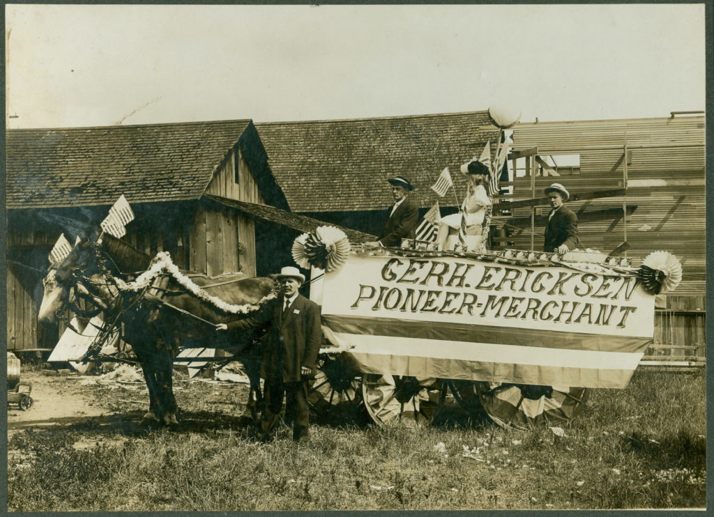
This street, which runs around 675 feet from 35th Avenue NE at NE 135th Street to Lake City Way NE at NE 137th Street, connecting the two arterials, was named, as local historian Valarie Bunn tells us in Gerhard Ericksen’s Good Road, after Norwegian immigrant Gerhard Johan Ericksen (1860, Molde, Norway – 1920, Bothell, Washington).
Parade float, July 4, 1908, for Gerhard Ericksen’s Mercantile, Bothell; Gerhard Ericksen at far left, son George Ericksen at far right
Ericksen, a Bothell merchant and Washington state legislator, was behind the creation of what is now the Washington State Department of Transportation, and the Gerhard Erickson Road (sic) was named in his honor. Bunn writes:
This road preceded the creation of Victory Way (Bothell Way/Lake City Way.)… In Wedgwood today, the Erickson Road route still exists as part of Ravenna Avenue NE north of NE 83rd Street.… as far as NE 110th Street. At the corner where Nathan Hale High School is located… the Erickson Road route took an eastward turn over to what is now 35th Avenue NE. At NE 135th Street, the 35th Avenue NE arterial angles over and merges with Lake City Way NE. The two-block portion from NE 135th to 137th Streets is still called Erickson Place NE.
Why the street is spelled Erickson instead of Ericksen is unknown.
Born and raised in Seattle, Benjamin Donguk Lukoff had his interest in local history kindled at the age of six, when his father bought him settler granddaughter Sophie Frye Bass’s Pig-Tail Days in Old Seattle at the gift shop of the Museum of History and Industry. He studied English, Russian, and linguistics at the University of Washington, and went on to earn his master’s in English linguistics from University College London. His book of rephotography, Seattle Then and Now, was published in 2010. An updated version came out in 2015.
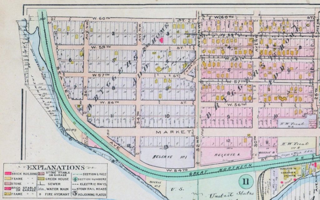
One of his blog posts is on NW Brygger Place, which runs around 650 feet from 26th Avenue NW in the east to 28th Avenue NW in the west, just south of NW 60th Street and the Ballard Community Center and Playfield. Its namesake was Anna Sophia Brygger (1853–1940), an immigrant from Norway, who also named Brygger Drive W in Magnolia after herself. Do check it out, along with the rest of his posts.
Map of Brygger’s 1st Home and 2nd Home Additions, Ballard, 1912 Baist’s Real Estate Atlas
Born and raised in Seattle, Benjamin Donguk Lukoff had his interest in local history kindled at the age of six, when his father bought him settler granddaughter Sophie Frye Bass’s Pig-Tail Days in Old Seattle at the gift shop of the Museum of History and Industry. He studied English, Russian, and linguistics at the University of Washington, and went on to earn his master’s in English linguistics from University College London. His book of rephotography, Seattle Then and Now, was published in 2010. An updated version came out in 2015.
This short street — just over 300 feet long — runs from Airport Way S in the east to Corson Avenue S in the west. It was established in 1903 as Carstens Street, part of Carstens’ Addition to Georgetown, “filed for record at the request of Thomas Carstens on the 4[th] day of June 1903 at 49 Min. past 9 A.M.” This is the first time I’ve seen the actual time of filing on a plat!
Thomas Carstens, born in 1865 in Husum, Germany, near Denmark, came to the Pacific Northwest in 1884, and in 1890 established a butcher shop with his brother, Ernest, which later grew into the Carstens Packing Company.
Clinton A. Snowden, author of History of Washington: The Rise and Progress of an American State, wrote in 1911 of Carstens:
Mr. Carstens, besides being president of the Carstens Packing Company, is president of the Tacoma Wheat Land Company, president of the Pacific Oil Mills, and director of the National Realty Company of Tacoma. He is a member of the Seattle Chamber of Commerce, Seattle Commercial Club, Arctic Club of Seattle, Seattle Manufacturers’ Association, Duwamish River Improvement Club, Tacoma Commercial Club, and Tacoma Chamber of Commerce.
Born and raised in Seattle, Benjamin Donguk Lukoff had his interest in local history kindled at the age of six, when his father bought him settler granddaughter Sophie Frye Bass’s Pig-Tail Days in Old Seattle at the gift shop of the Museum of History and Industry. He studied English, Russian, and linguistics at the University of Washington, and went on to earn his master’s in English linguistics from University College London. His book of rephotography, Seattle Then and Now, was published in 2010. An updated version came out in 2015.
This street, which runs just under 400 feet from Yesler Way and 3rd Avenue S in the northwest to S Washington Street and 4th Avenue S in the southwest, cutting a skewed diagonal through the block, is named for Father Francis X. Prefontaine, Seattle’s first Catholic priest. In 1870, he founded Seattle’s first Catholic church, Our Lady of Good Help, on the block Prefontaine Place cuts through today.
Born and raised in Seattle, Benjamin Donguk Lukoff had his interest in local history kindled at the age of six, when his father bought him settler granddaughter Sophie Frye Bass’s Pig-Tail Days in Old Seattle at the gift shop of the Museum of History and Industry. He studied English, Russian, and linguistics at the University of Washington, and went on to earn his master’s in English linguistics from University College London. His book of rephotography, Seattle Then and Now, was published in 2010. An updated version came out in 2015.
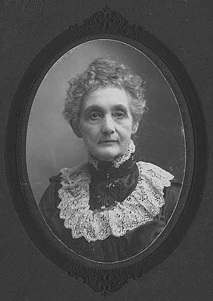
This street runs just over a thousand feet from 10th Avenue W and W Bertona Street in the northwest to 8th Avenue W and W Dravus Street in the southeast. It was named after Susan Conkling Prosch, mother of Thomas Prosch, who filed Prosch’s Queen Anne Addition to the City of Seattle in 1909. (Prosch was a noted local journalist and historian, who didn’t neglect to name Prosch Avenue W after himself.)
Susan Conkling Prosch, 1897
Conkling Place was one of the streets retained when George E. Morford and Gertrude Keen Morford filed their plat of Queen Anne Park in 1926. The Queen Anne Historical Society has an extensive article on the latter subdivision, which was among those in Seattle with all-too-common racial restrictive covenants, in this case excluding Blacks and Asians.
Portion of Prosch’s Queen Anne Addition to the City of Seattle, 1909.
Born and raised in Seattle, Benjamin Donguk Lukoff had his interest in local history kindled at the age of six, when his father bought him settler granddaughter Sophie Frye Bass’s Pig-Tail Days in Old Seattle at the gift shop of the Museum of History and Industry. He studied English, Russian, and linguistics at the University of Washington, and went on to earn his master’s in English linguistics from University College London. His book of rephotography, Seattle Then and Now, was published in 2010. An updated version came out in 2015.
This street, which runs just over 400 feet from 36th Avenue W in the west to 34th Avenue W in the east, was established in 1905 as part of the Lawton Park Addition to Seattle. It was named after Evan Sidebottom McCord, a Seattle lawyer, and his wife, Elizabeth Chenault Bennett McCord, who were among the nine owners of property encompassed by the plat.
Born and raised in Seattle, Benjamin Donguk Lukoff had his interest in local history kindled at the age of six, when his father bought him settler granddaughter Sophie Frye Bass’s Pig-Tail Days in Old Seattle at the gift shop of the Museum of History and Industry. He studied English, Russian, and linguistics at the University of Washington, and went on to earn his master’s in English linguistics from University College London. His book of rephotography, Seattle Then and Now, was published in 2010. An updated version came out in 2015.
I am certainly not the first person to have been interested in, or to blog about, the origins of Seattle street names. One of the historians whose work I’ve been inspired by is Valarie Bunn, who writes Wedgwood in Seattle History (though she does not restrict herself to Wedgwood).
In “The Fischer Farm in Meadowbrook,” from 2013, she writes about August and Wilhelmine Fischer, who came to Seattle from Saxony, Germany, in 1888, and lived here until they died in 1940 and 1941, respectively. In 1922, they established what is now Fischer Place NE as Fischer Street in the plat of Fischer’s Highway Garden Tracts. (“Highway” because of Victory Way [now Lake City Way NE, part of State Route 522] and Pacific Highway [now Ravenna Avenue NE]. The latter lost its Pacific Highway designation to the former that same year, and the designation shifted farther west to what is now Aurora Avenue N a number of years later.) I highly recommend this article and her entire blog.
Born and raised in Seattle, Benjamin Donguk Lukoff had his interest in local history kindled at the age of six, when his father bought him settler granddaughter Sophie Frye Bass’s Pig-Tail Days in Old Seattle at the gift shop of the Museum of History and Industry. He studied English, Russian, and linguistics at the University of Washington, and went on to earn his master’s in English linguistics from University College London. His book of rephotography, Seattle Then and Now, was published in 2010. An updated version came out in 2015.
This street, which runs about 850 feet from NE 63rd Street and 17th Avenue NE in the northwest to 20th Avenue NE in the southeast, was established in 1906 as part of the University Scenic Addition to the City of Seattle, platted by “Naomi A. Young and S.E. Young, her husband.”
Born and raised in Seattle, Benjamin Donguk Lukoff had his interest in local history kindled at the age of six, when his father bought him settler granddaughter Sophie Frye Bass’s Pig-Tail Days in Old Seattle at the gift shop of the Museum of History and Industry. He studied English, Russian, and linguistics at the University of Washington, and went on to earn his master’s in English linguistics from University College London. His book of rephotography, Seattle Then and Now, was published in 2010. An updated version came out in 2015.
This street runs a tenth of a mile along the Bitter Lake waterfront from N 134th Street to the grounds of Broadview-Thomson K-8 School and Bitter Lake Playground. It was established in 1923 as part of Bitter Lake Villa Tracts.
Bitter Lake itself was so named because, as HistoryLink puts it, “A small, lake-bound sawmill operation at the southwest corner of Bitter Lake contracted with the Puget Mill and Brown Bay Logging Company to process their lumber cut from nearby forests. The tannic acid from logs dumped into the lake was so bitter that horses refused to drink from it, thus giving the 20-acre pond its name.” Its native name is čʼalqʼʷadiʔ, meaning ‘blackcaps on the sides’.
Born and raised in Seattle, Benjamin Donguk Lukoff had his interest in local history kindled at the age of six, when his father bought him settler granddaughter Sophie Frye Bass’s Pig-Tail Days in Old Seattle at the gift shop of the Museum of History and Industry. He studied English, Russian, and linguistics at the University of Washington, and went on to earn his master’s in English linguistics from University College London. His book of rephotography, Seattle Then and Now, was published in 2010. An updated version came out in 2015.
This short street in the Washington Park neighborhood runs just over a tenth of a mile from Lake Washington Boulevard E in the west to 36th Avenue E in the east, a block south of E Mercer Street.
The Pacific Coast Company rail, shipping and coal operations served the West Coast from the mid-19th century until its last railways were abandoned or sold in the mid-20th century. Though the company was organized under the Pacific Coast Company name in late 1897, it comprised several existing organizations, most notably the Pacific Coast Steamship Co., Pacific Coast Coal Co., and the Pacific Coast Railway. In Seattle, the Columbia & Puget Sound Railroad, originally the Seattle & Walla Walla, became part of the Pacific Coast Railway in 1916. The several operations of Pacific Coast Co., which also included a cement company and engineering company, played an important role in the development of King County resources and the development of Seattle and outlying communities.
Born and raised in Seattle, Benjamin Donguk Lukoff had his interest in local history kindled at the age of six, when his father bought him settler granddaughter Sophie Frye Bass’s Pig-Tail Days in Old Seattle at the gift shop of the Museum of History and Industry. He studied English, Russian, and linguistics at the University of Washington, and went on to earn his master’s in English linguistics from University College London. His book of rephotography, Seattle Then and Now, was published in 2010. An updated version came out in 2015.
Hubbell Place does not appear in the original plat of the area, A.A. Denny’s Broadway Addition to the City of Seattle (1890). When it was established in 1906, it ran only one block, diagonally from 9th Avenue and Union Street to Terry Avenue and Pike Street. Today, however, it begins farther southwest, at 7th Avenue and Spring Street, making its full length just about ⅓ of a mile. (The extension came about because of the construction of Interstate 5 through Downtown — the frontage road on the east side of I-5 connected to the existing Hubbell Place and took its name in 1966.)
The ordinance establishing Hubbell Place “accept[s] a deed of conveyance from George S. McLaren, et ux, and Helen Moore Hubbell” for the land. Et ux is simply Latin for “and wife.” But who was this Helen Hubbell — and, for that matter, who was this George McLaren? Could he be connected with W McLaren Street in Magnolia? (We’ll take that up in a subsequent post.)
Searching for any city ordinance mentioning Hubbell, we come across one “granting permission to Frank B. Hubbell, his heirs and assigns, to lay down, maintain and operate steam and water pipes in and across certain streets and alleys in the City of Seattle for the purpose of conducting steam and water,” passed in 1905. Yet in 1907 it was repealed, and in 1909 a similar ordinance was passed “granting permission to Helen Moore Hubble [italics mine]” to do the same thing. (This franchise expired a number of decades later.) Why might this have happened?
Apparently, Frank B. Hubbell died in 1905, only a few months after he married Helen. As the (Walla Walla) Evening Statesman reported on October 28 of that year, under the headline ‘Seattle capitalist commits suicide’,
Mystery surrounds the suicide by gas last night of Frank B. Hubbell, one of the most prominent real estate men and capitalists in the city. His bride of three months, who occupied separate apartments in a fashionable hotel, discovered him unconscious on the floor of his room this morning. Hubbell was worth half a million dollars and his financial standing was gilt edge. He came from New York a few years ago. Three physicians failed to save his life and he died at 10 this morning. No cause is known for his suiciding. Hubbel [sic] when found had the gas tube in his mouth. Domestic and not financial troubles, are believed to have been the cause. Hubbell had under way some of the greatest public improvements in the history of the city. He has constantly been drawing on eastern capital to accomplish his plans.
Though the Evening Statesman did not believe financial troubles to be the cause of his suicide, The Yakima Heraldreported in 1910, under the headline ‘Closing of Hubbell estate solves suicide mystery’, that he owed $135,000 to Seattle banks, could not pay without putting his fortune at risk, and so decided to kill himself to keep his creditors at bay and preserve his estate for his wife. (That figure corresponds to $3.5 million in today’s money. The Herald went on to say that his total estate amounted to $650,000, or about $16.8 million.)
Frank and Helen Moore Hubbell had one daughter, Helen Frances Hubbell, who apparently died a few months after her 17th birthday in a car accident. She was born in May 1906, 6½ months after the death of her father. The elder Helen died in 1948 at the age of 70.
Born and raised in Seattle, Benjamin Donguk Lukoff had his interest in local history kindled at the age of six, when his father bought him settler granddaughter Sophie Frye Bass’s Pig-Tail Days in Old Seattle at the gift shop of the Museum of History and Industry. He studied English, Russian, and linguistics at the University of Washington, and went on to earn his master’s in English linguistics from University College London. His book of rephotography, Seattle Then and Now, was published in 2010. An updated version came out in 2015.
This street, established in 1991 as part of the development of the Elliott Bay Marina at the southern foot of Magnolia Bluff, runs ⅖ of a mile west from 23rd Avenue W to just shy of the 30th Avenue W street end beach.
While the origin of its name may not be interesting, the story of its establishment is a bit more so:
The marina itself began the permitting process in 1983, but lawsuits delayed its creation for nearly a decade. The Muckleshoot Indian Tribe and Suquamish Tribe sued to block its construction on the basis that “construction of the Marina would eliminate a portion of one of their usual and accustomed fishing areas in Elliott Bay and thus would interfere with their treaty right to fish at the Marina site.” Homeowners on the bluff above intervened on the side of the developers, as “the area has had numerous major landslides that have left several homes at the crest of the bluff at risk and have repeatedly caused breaks in a trunk sewer line located at the base of the bluff.… The Marina construction includes the placement of 500,000 cubic yards of fill at the toe of the bluff, which would stabilize the area.” Eventually, a settlement was reached, which “calls for ongoing fisheries-related expenses paid to the tribe, which will be funded by a percentage of the moorage income.… [the] ‘Indian Treaty Surcharge.’”
I believe this was the last major fill operation within Seattle city limits. Such a development would be all but unthinkable today.
The marina was built on tidelands where W Lee Street and Puget Avenue W were platted but never built. They were vacated and W Marina Place was established. When it came to naming the access road, the developers originally proposed W Marina Boulevard, contending that as the road fell between the W Oakes Street right-of-way and the former W Lee Street right-of-way, it wasn’t a violation of the city’s principle of maintaining street grid names as much as possible. This was initially rejected by the city, which preferred W Lee Street, but after further discussion, W Marina Place was settled on. An interesting point the developers made was that as W Lee Street had never physically existed in Magnolia, though it had been platted there, calling the access road W Lee Street could actually be confusing, as “people familiar with Seattle streets know that there is no W Lee Street on Magnolia. Rather, they know W Lee Street as being on Queen Anne Hill.” Still, though, I have to believe they were more interested in their own vanity — Marina Boulevard? — than any particular concern for folks’ ability to navigate.
For some reason, the public street ends just feet from the 30th Avenue W street end beach. I’m not entirely sure why that is; I don’t think the marina is opposed to public access to the beach; otherwise, they wouldn’t be in favor of the Magnolia Trail project, which would connect W Marina Place to W Galer Street, 32nd Avenue W, and thence to Magnolia Village.
Born and raised in Seattle, Benjamin Donguk Lukoff had his interest in local history kindled at the age of six, when his father bought him settler granddaughter Sophie Frye Bass’s Pig-Tail Days in Old Seattle at the gift shop of the Museum of History and Industry. He studied English, Russian, and linguistics at the University of Washington, and went on to earn his master’s in English linguistics from University College London. His book of rephotography, Seattle Then and Now, was published in 2010. An updated version came out in 2015.
This street, which runs ³⁄₁₀ of a mile from Fuhrman Avenue E to E Allison Street, was established as an alley in 1890 as part of the Denny–Fuhrman Addition to the City of Seattle, but only received a name in 1936. It was named for Portage Bay, the eastern arm of Lake Union, which it parallels. Portage Bay was in turn named for the portage from Union Bay (part of Lake Washington) to Lake Union over the Montlake Isthmus, which is today the Montlake Cut of the Lake Washington Ship Canal.
Born and raised in Seattle, Benjamin Donguk Lukoff had his interest in local history kindled at the age of six, when his father bought him settler granddaughter Sophie Frye Bass’s Pig-Tail Days in Old Seattle at the gift shop of the Museum of History and Industry. He studied English, Russian, and linguistics at the University of Washington, and went on to earn his master’s in English linguistics from University College London. His book of rephotography, Seattle Then and Now, was published in 2010. An updated version came out in 2015.
This short street, which runs from NE 50th Street just south of Calvary Cemetery to NE 45th Place, is named for its view of the University of Washington campus to the southwest. It was laid out in 1907 as part of the Exposition Heights addition, which was named after the upcoming Alaska–Yukon–Pacific Exposition on the UW campus.
Born and raised in Seattle, Benjamin Donguk Lukoff had his interest in local history kindled at the age of six, when his father bought him settler granddaughter Sophie Frye Bass’s Pig-Tail Days in Old Seattle at the gift shop of the Museum of History and Industry. He studied English, Russian, and linguistics at the University of Washington, and went on to earn his master’s in English linguistics from University College London. His book of rephotography, Seattle Then and Now, was published in 2010. An updated version came out in 2015.
Seattle’s newest street name is no longer E Barbara Bailey Way but NW Locks Place — formerly the block of NW 54th Street that ran between NW Market Street and the entrance to the Hiram M. Chittenden Locks, more commonly known as the Ballard Locks.
Ordinance 125947, passed by the city council in late September, was signed by the mayor the next week and went into effect a few days ago. As the Seattle Department of Transportation explained this summer, the name change stemmed from a request by emergency dispatchers: previously, there were two locations in which NW Market Street and NW 54th Street intersected; once in front of the locks and once over a mile to the east, where Market descends from Phinney Ridge. This name change will serve to eliminate any confusion about what is meant by “the intersection of 54th and Market.”
A similar change was made to Green Lake street names in 1961, when the various segments of Green Lake Way north of NE Ravenna Boulevard and N 72nd Street were changed to Green Lake Drive — previously, Latona Avenue NE, Sunnyside Avenue N, and Ashworth Avenue N (to name a few) had intersected Green Lake Way twice.
Interestingly, only the Lockspot Cafe’s address (3005) is affected by this name change. The other buildings fronting NW Locks Place have addresses on NW Market Street, and the address of the Ballard Locks remains 3015 NW 54th Street.
Born and raised in Seattle, Benjamin Donguk Lukoff had his interest in local history kindled at the age of six, when his father bought him settler granddaughter Sophie Frye Bass’s Pig-Tail Days in Old Seattle at the gift shop of the Museum of History and Industry. He studied English, Russian, and linguistics at the University of Washington, and went on to earn his master’s in English linguistics from University College London. His book of rephotography, Seattle Then and Now, was published in 2010. An updated version came out in 2015.