Candy Cane Lane

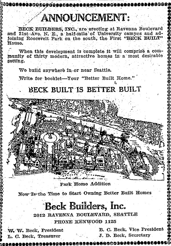
It’s that time of year again, when NE Park Road and Park Road NE (which form a loop connecting Ravenna Avenue NE and 21st Avenue NE north of NE Ravenna Boulevard) transform themselves into Candy Lane Lane. A Christmas tradition which began 75 years ago, it’s, as local historian Valarie Bunn describes it,

A fun family holiday event in northeast Seattle… a cluster of houses all decked out in lights and themed decorations.… Pedestrians are welcome at all times, and you are encouraged to walk through for a closer look at the lights and decorations. 

Visit her blog post or the Candy Cane Lane Facebook page for more details. The display runs through January 1.

Candy Cane Lane Season's Greetings sign, December 2013
Season’s Greetings from Candy Cane Lane sign, December 2013. Photograph by Flickr user Frank Fujimoto, licensed under Creative Commons Attribution-NonCommercial-NoDerivs 2.0 Generic

Twin Maple Lane NE

This private cul-de-sac at the end of 24th Avenue NE south of NE 60th Street appears, according to an article in the June 19, 1927, edition of the Seattle Post-Intelligencer, to have been established that very year. According to James Bush writing for the Seattle Sun, Ravenna Park (or perhaps a portion thereof) was once known as Twin Maple Park, and

[William Wirt] Beck is officially remembered by two of the smallest civic gestures ever performed. In keeping with the early practice of giving names to small bits of park property, the concrete-covered triangle of land at the intersection of 15th Avenue Northeast and Cowen Place was dubbed Beck Place. And, his beloved Twin Maples Park is memorialized by Twin Maples Lane Northeast, a half-block street where 24th Avenue Northeast meets the park border.

Note that the typos are in the Sun article, not this post — the sign quite clearly says Maple, not Maples.

Park Road NE

Like its twin, NE Park Road, this street originates in the 1923 Park Home Addition developed by William Wirt Beck. They are the home of Candy Cane Lane, which has been a local Christmas attraction since 1948.

Park Road NE begins as an extension of 21st Avenue NE at NE Ravenna Boulevard and goes around 100 feet north to NE Park Road at Park Home Circle.

NE Park Road

This street and its twin, Park Road NE, date to 1923, when William Wirt Beck developed the Park Home Addition between NE Ravenna Boulevard and Ravenna Park. They are best known for being the location of Candy Cane Lane, which has been a local Christmas attraction since the late 1940s. (The Park Road house of one Eugene Shostrom frequently appeared on The Seattle Times’ Christmas Tree Trail list before then, but it wasn’t until 1948 that the neighborhood as a whole participated — and won the award for best community display. [I wonder where that loving cup is today…])

Candy Cane Lane Season's Greetings sign, December 2013
Season’s Greetings from Candy Cane Lane sign, December 2013. Photograph by Flickr user Frank Fujimoto, licensed under Creative Commons Attribution-NonCommercial-NoDerivs 2.0 Generic

NE Park Road begins at NE Ravenna Boulevard just west of Ravenna Avenue NE and goes around 350 feet first north, then west, to Park Road NE at Park Home Circle.

Park Home Addition Ad, The Seattle Times, April 30, 1923

Union Bay Place NE

This street, which runs ⅕ of a mile from 30th Avenue NE in the northwest to the “five corners” intersection with NE 45th Street, NE 45th Place, and Mary Gates Memorial Drive NE, was created in 1907 as part of the Exposition Heights addition. Four years later, the street was extended southeast of NE 45th Street through University of Washington property to NE 41st Street. However, in 1995 that portion was renamed Mary Gates Memorial Drive NE.

As can be seen in the map below, it did once parallel Union Bay; however, when the Montlake Cut of the Lake Washington Ship Canal opened in 1916, the lake and bay dropped by 8.8 feet to match the level of Lake Union and this was no longer waterfront property. The southwest corner of this map is now entirely devoted to commercial and residential use.

Portion of plat map of Exposition Heights showing Union Bay and Union Bay Place

Union Bay itself was named in 1854 by settler Thomas Mercer, with the idea that it and Lake Union, which he also named, would one day be part of a connection from Lake Washington to Puget Sound. As mentioned above, this did end up happening 62 years later.

NE Naomi Place

This street, which runs about 850 feet from NE 63rd Street and 17th Avenue NE in the northwest to 20th Avenue NE in the southeast, was established in 1906 as part of the University Scenic Addition to the City of Seattle, platted by “Naomi A. Young and S.E. Young, her husband.”

Naomi Althouse Young, June 1928

Naomi Althouse Young and Samuel E. Young were from Albany, Oregon, where they and son Percy Althouse Young operated the S.E. Young & Son department store (see more about the building’s history). S.E. Young was also president of the First National and First Savings Banks. In 1940, Anna Althouse, niece of Naomi Young and cousin of Percy, reminisced about the early days of Albany, in which her family played a large part, though “now there are none left save myself and my cousin Percy Young of this city.”

University View Place NE

This short street, which runs from NE 50th Street just south of Calvary Cemetery to NE 45th Place, is named for its view of the University of Washington campus to the southwest. It was laid out in 1907 as part of the Exposition Heights addition, which was named after the upcoming Alaska–Yukon–Pacific Exposition on the UW campus.

Alaska–Yukon–Pacific Exposition Seattle 1909