SW Bataan Street

High Point, originally developed by the Seattle Housing Authority in 1942 as defense housing, was redeveloped in 2004. It was reconnected to the street grid, and as part of the process some street names, including SW Snow Court, Cycle Lane SW, MacArthur Court SW, and Bataan Place SW, were eliminated. (They are still visible in the city clerk’s geographic indexing atlas, which was created before the redevelopment and has not been updated.) No one appeared to care much about the loss of Snow, Cycle, or MacArthur (named for General Douglas MacArthur, who had recently evacuated to Australia when the fall of the Philippines seemed imminent).* The loss of Bataan, named for the World War II battle that took place on the Bataan Peninsula on the island of Luzon, was another story, however, and SW Eddy Street was quickly renamed SW Bataan Street, enabling the city to continue to “memorialize and honor the 10,000 American and Filipino soldiers who lost their lives in the Bataan death march.”

* See the August 7, 1943, Seattle Times article ‘City’s Wartime Additions Inspire Some Monickers’ for the story behind the street names in High Point, Rainier Vista, and other Seattle Housing Authority projects.

W Marginal Way SW

W Marginal Way SW, like its twin across the water, E Marginal Way S, began literally as a “marginal way” to “give railroads, street cars and other transportation facilities access to the Duwamish waterway.”

W Marginal Way SW begins at 26th Avenue SW at the Port of Seattle’s Terminal 5. From there, it’s 3 miles southeast to 2nd Avenue SW, by the south end of the 1st Avenue S Bridge. It resumes on the east side of the bridge as W Marginal Way S, an extension of Highland Park Way SW, and runs 4⅖ miles from there to the southern city limits. (For all but the first few blocks of this stretch, it is a limited-access highway carrying Washington State Route 99.) Beyond there it runs 3½ miles more to the vicinity of an interchange with Tukwila International Boulevard. The name is dropped at this point (and does not appear on signs south of the initial few blocks); the highway continues 1¾ miles as Washington State Route 599 to Interstate 5.

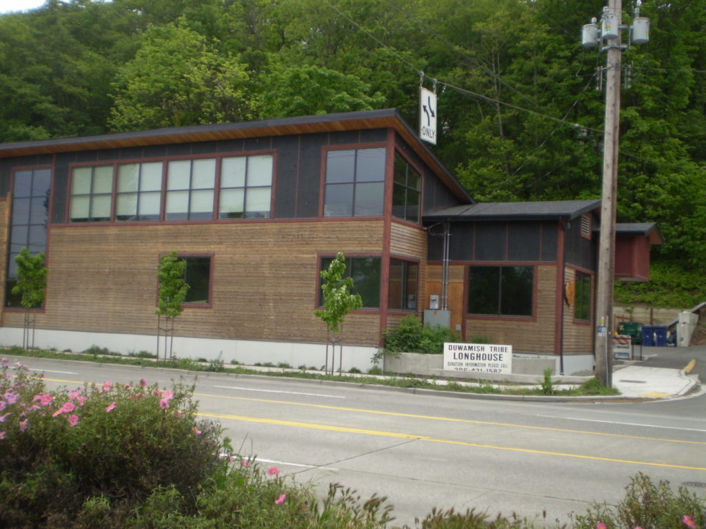
Duwamish Longhouse and Cultural Center, 4705 W Marginal Way SW, May 2010
Duwamish Longhouse and Cultural Center, 4705 W Marginal Way SW, May 2010. Photograph by Benjamin Lukoff, originally appearing in Seattle Then and Now.
Copyright © 2010 Benjamin Lukoff. All rights reserved.

W Marginal Way S is the location of the Duwamish Longhouse and Cultural Center, across the street from həʔapus Village Park and Shoreline Habitat (formerly Terminal 107 Park). həʔapus, or x̌əʔapus, was the name of a Duwamish village that was burned down by settlers in 1895. The new longhouse became the first one within city limits in 114 years. Notably, descendants of settlers Charles Terry and David Denny participated in fundraising and advocacy, without which the project would have been impossible, as the Duwamish were forced to purchase back the land. (A good article for more detail is “On the Duwamish River, a longhouse rises,” which appeared in Real Change in March 2009.)

Plan of the Duwamish Waterway, Seattle Post-Intelligencer, August 31, 1913, page 44
Plan of the Duwamish Waterway, from the August 31, 1913, issue of the Seattle Post-Intelligencer, page 44

S Front Street

Usually, a Front Street designates a city’s waterfront. Front Street in Philadelphia parallels the Delaware River; NW Front Avenue in Portland, Oregon, goes up the Willamette River; Front Street in Toronto runs along Lake Ontario. Seattle once had a prominent Front Street alongside Elliott Bay, but it was renamed 1st Avenue in 1895. The Front Street we do have runs a grand total of ⅖ of a mile split among three segments, and it runs east–west, while the nearby Duwamish River runs north–south. Why is this?

As it turns out, S Front Street — established as part of Joseph R. McLaughlin’s Water Front Addition to the City of Seattle in 1906 — did use to run along the river, before it was rechanneled beginning in 1913. (Here is an excellent post from the Burke Museum on the Duwamish meanders, with some great maps and aerials.) The maps below show its course along the Duwamish River Oxbow in 1912 (left) and its current landlocked state (right). You can still make out its former location, as well as small remnants in the form of the Slip 2 and Slip 3 inlets. (Incidentally, Front Street originally was shaped like a horseshoe — today’s S Front Street was originally North Front Street, and South Front Street is today S River Street.)

Portion of index page of Baist's Real Estate Atlas of Seattle, 1912, showing Duwamish River oxbowPortion of King County Parcel Viewer map and aerial view of Seattle showing former location of Duwamish River oxbow

Speaking of the Oxbow, here’s an advertisement for it. So much for that “16,000 feet of deep water frontage.”

Advertisement for Oxbow in June 1, 1906, issue of The Seattle Times

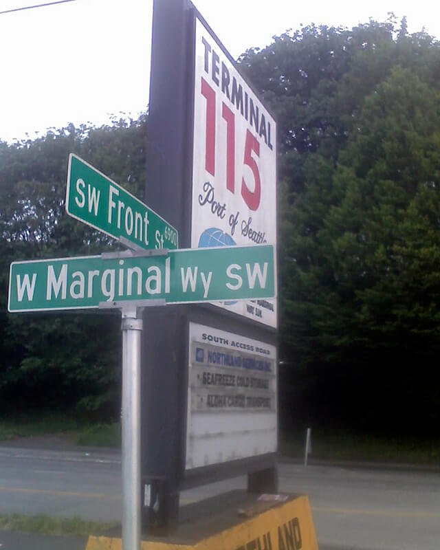
Today’s S Front Street begins at 6th Avenue S and goes ¼ of a mile west, ending just beyond 4th Avenue S. There is another 400-foot-long section between E Marginal Way S and 1st Avenue S, below the approach to the 1st Avenue S Bridge. And then there is one last 200-foot-long section on the west side of the Duwamish River — SW Front Street starts at W Marginal Way SW and ends at the entrance to the Port of Seattle’s Terminal 115 (which used to be Boeing Plant 1, the airplane manufacturer’s first production facility).

Incidentally, here’s a great article on the one in New Orleans I came across while looking up various Front Streets. It’s hard to beat a lede like this: “In a city replete with famed streets, scenic avenues and poetic street names, one particular artery excels at being obscure, nominally insipid, marvelously intermittent, and sometimes barely even a street.”

Sign at corner of SW Front Street and W Marginal Way SW, May 20, 2013
Sign at corner of SW Front Street and W Marginal Way SW, May 20, 2013. Photograph by Benjamin Lukoff. Copyright © 2013 Benjamin Lukoff. All rights reserved.

Vashon Place SW

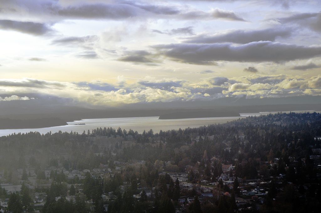
This street — just about 350 feet long, like its neighbor Blake Place SW — connects SW Othello Street to Fauntleroy Way SW just north of Solstice Park. Created as part of the Lincoln Home Addition in 1907 by builder Albert Eugene Felmley and his wife, Mabel L. Felmley, it is named after Vashon Island, located 4 miles to the southwest, across Puget Sound. The island itself was named for Royal Navy Admiral James Vashon by his friend, Royal Navy Captain George Vancouver, in 1792.

Two other streets in the Lincoln Home Addition are named for Puget Sound islands: the already-mentioned Blake Place SW, and Bainbridge Place SW.

Aerial view of Vashon Island from the northwest
Aerial view of Vashon and Maury Islands from the northwest. Photograph by Flickr user Travis, licensed under Creative Commons Attribution-NonCommercial 2.0 Generic

Blake Place SW

This 350-foot-long street connects SW Othello Street to SW Fontanelle Street just north of Solstice Park. It was created as part of the Lincoln Home Addition in 1907 by builder Albert Eugene Felmley and his wife, Mabel L. Felmley, and is named after Blake Island, located 4⅖ miles to the west, across Puget Sound. The island itself was named for U.S. Navy Commodore George Smith Blake, then head of the United States Coast Survey, by Charles Wilkes in 1841.

Two other streets in the Lincoln Home Addition are named for Puget Sound islands: Bainbridge Place SW and Vashon Place SW.

Aerial view of Blake Island from the east
Aerial view of Blake Island from the east (West Seattle in foreground). Photograph by Joe Mabel, Wikimedia Commons, licensed under Creative Commons Attribution-Share Alike 3.0 Unported

Bainbridge Place SW

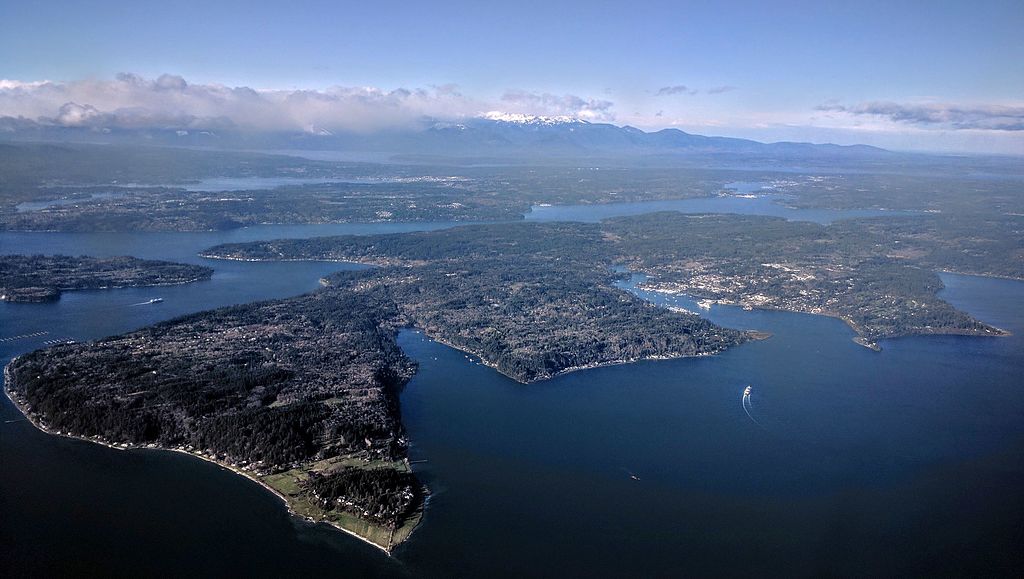
This short street — not quite 275 feet long — connects SW Othello Street to Fauntleroy Way SW just north of Lincoln and Solstice Parks. Created as part of the Lincoln Home Addition in 1907 by builder Albert Eugene Felmley and his wife, Mabel L. Felmley, it is named after Bainbridge Island, located 5¼ miles to the northwest, across Puget Sound. The island itself was named for U.S. Navy Commodore William Bainbridge, commander of the USS Constitution, by Charles Wilkes in 1841.

Two other streets in the Lincoln Home Addition are named for Puget Sound islands: Blake Place SW and Vashon Place SW.


Aerial view of Bainbridge Island from the southeast
Aerial view of Bainbridge Island from the southeast. Photograph by Dicklyon, Wikimedia Commons, licensed under Creative Commons Attribution-Share Alike 4.0 International

S Fontanelle Street

This fragmented street starts at Rainier Avenue S and travels two blocks west to 46th Avenue S. It makes its next appearance in Beacon Hill as a block-long street hanging off Military Road S, just east of Interstate 5. There are a few more blocks in South Park, from 5th to 2nd Avenues S, then half a block in West Seattle just west of California Avenue SW and a few final blocks from just east of Vashon Place SW to 47th Avenue SW at Lincoln Park. It is named for Fontanelle, Iowa, where Joseph and Catherine (Henderson) Dunlap (of S Henderson Street) lived before coming to Seattle in 1869.

S Henderson Street

This street is named for Catherine Henderson (1822–1891), wife of Joseph Dunlap (1818–1893), who gives his name to Dunlap Elementary School and the Dunlap section of Rainier Valley. HistoryLink writes of the couple, who came to Seattle from Fontanelle, Iowa:

Joseph and Catherine (Henderson) Dunlap arrived in the Puget Sound region in September 1869, having traveled by covered wagon from Iowa. According to family legend, when they arrived in the Puget Sound region, they followed a road over Beacon Hill and sent their son George up a tree to view the land to the south and east. There he spotted a flat valley and Lake Washington. The Dunlaps decided to homestead in that valley, located to the south of the Van Asselt and Mapel families. They claimed 120 acres extending east toward Rainier Beach.

It appears to have been Lake Street in the original Dunlap’s Plat of Land on Lake Washington (1889) but was likely changed when Rainier Beach was annexed to Seattle in 1907.

Today, S Henderson Street begins at Seward Park Avenue S, just west of Be’er Sheva Park, and runs ¾ of a mile west to Carkeek Drive S. On the other side of Interstate 5 and the Duwamish River, it runs ⁹⁄₁₀ of a mile through South Park from just east of 14th Avenue S to just west of 2nd Avenue S, the portion over Highway 99/W Marginal Way S being a footbridge. Once in West Seattle, SW Henderson Street runs ⅔ of a mile from 8th Avenue SW, just west of Westcrest Park, to 21st Avenue SW, where the arterial turns into SW Barton Place, and is then a two-block residential street from 22nd Avenue SW to 25th Avenue SW, where it is blocked by the Westwood Village shopping mall. On the other side of the mall, it’s ⅘ of a mile from 28th Avenue SW to SW Barton Street at Fauntleroy Park, and then a final couple of blocks from 43rd Place SW to Fauntleroy Way SW, just north of Washington State Ferries’ Fauntleroy Terminal.


California Avenue SW

This West Seattle street was established in 1888 as part of the First Plat of West Seattle by the West Seattle Land and Improvement Company. As “most of [its] capital came from San Francisco,” I would assume that is why California Avenue was given its name.

California Avenue SW — a major West Seattle arterial connecting the Admiral, Alaska, and Morgan Junctions (three commercial hubs named after long-gone streetcar line intersections) — runs 4½ miles from California Lane SW in the north, past which it turns into California Way SW on its way down the hill to the waterfront, to SW Sullivan Street in the south. Beyond there it exists as a few short segments, then briefly as part of the SW Brace Point Drive–SW Barton Street arterial, and lastly as a nearly mile-long residential street that ends at Marine View Drive SW.

Sign at corner of SW Donald Street and California Avenue SW, July 4, 2011
Sign at corner of SW Donald Street and California Avenue SW, July 4, 2011. Photograph by Benjamin Lukoff. Copyright © 2011 Benjamin Lukoff. All rights reserved.

S Angeline Street

This street lies mostly in Columbia City, where its name originated, and Seward Park, with a few blocks in Beacon Hill and even fewer in West Seattle. It almost reaches Puget Sound at Beach Drive SW, and does reach Andrews Bay of Lake Washington at Lake Washington Boulevard S.

As noted, the name Angeline Street originated in Columbia City, in this 1891 Plat of Columbia, filed at the request of James Kippen Edmiston by Percy W. Rochester and John I. Wiley of the Washington Co-operative Home Company. 

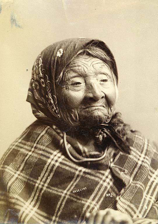
Princess Angeline was born Kikisoblu, the daughter of Si’ahl [siʔaɫ], better known in English as Chief Seattle of the Duwamish and Suquamish Tribes. Her date of birth is unknown; Wikipedia gives it as ca. 1820, whereas this article posted by the Duwamish Tribe, written by elementary school students based on HistoryLink essays, gives it as 1828. She died May 31, 1896.

Princess Angeline received her English name from Catherine Broshears Maynard, wife of David Swinson (“Doc”) Maynard, one of the earliest Seattle settlers. As the HistoryLink Elementary article puts it,

Chief Seattle’s oldest daughter was named Kikisoblu. She became friends with many of Seattle’s founding families. One of her friends was Catherine Maynard. She felt that Kikisoblu should have a name that would let the white settlers know that she was the daughter of a great chief. So she called her Princess Angeline. She thought that name was prettier than the name Kikisoblu.

Photograph of Kikisoblu, or Princess Angeline, by Frank La Roche, ca. 1893
Photograph of Princess Angeline (Kikisoblu), by Frank La Roche, ca. 1893

Delridge Way SW

This street runs nearly four miles from Chelan Avenue SW, SW Spokane Street, and W Marginal Way SW in the north to 16th Avenue SW and SW Roxbury Street in the south — all the way from the Duwamish Waterway to the southern city limits. It was given its current name in 1940 — before then, it had carried the names of Youngstown Place, 21st Avenue SW, 22nd Avenue SW, McKinnon Place SW, 23rd Avenue SW, and 24th Avenue SW. As The Seattle Times explained on May 14, 1940, “Delridge” came from “the dells and ridges through which the thoroughfare runs,” and had been “suggested by West Seattle community organizations.”

Fauntleroy Way SW

This 4-mile-long thoroughfare runs from the west end of the West Seattle Bridge to Brace Point, passing Morgan Junction, Lincoln Park, and the Fauntleroy Ferry Terminal on the way. It was named for Fauntleroy Cove, location of that terminal, from which riders depart for Vashon Island and Southworth, on the Kitsap Peninsula.

Fauntleroy Cove was itself named after Robert Henry Fauntleroy by George Davidson, Fauntleroy’s future son-in-law. They were both members of the U.S. Coast Survey. He is one of three Fauntleroys whose names appear on Seattle street signs — Ellinor Drive W and Constance Drive W are named for Mounts Ellinor and Constance in the Olympic Mountains, themselves named by Davidson after his future wife and sister-in-law, respectively.

SW Seattle Street

What better way to start things off than with SW Seattle Street?

SW Seattle Street is a minor residential street in West Seattle that runs about ³/₁₀ of a mile from 42nd Avenue SW in the east to Sunset Avenue SW in the west.

It might seem strange that such a short street would be chosen to bear the city’s name — it was the only one to do so until 2010, when the first two blocks of Airport Way S were renamed Seattle Boulevard S — but this has more to do with unimaginative naming than with civic pride.

On August 4, 1869, Ike M. Hall — the executor of the estate of Norman B. Judkins — filed the Judkin’s (sic) Addition to the Town of Seattle, located just southwest of where the interchange between I-5 and I-90 is today. From north to south, the east–west streets are named Norman, B, Judkins, Addition, Town, and Seattle.

Portions of the original Seattle Street were vacated over the years (for example, in 1900, 1957, and 2000), and the construction of I-5 took care of the rest. However, when the city annexed West Seattle in 1907 it changed the name of Maple Street to W Seattle Street as part of rationalizing the street grid… and so the name lives on.

(The city itself, of course, was named after Si’ahl [siʔaɫ], better known in English as Chief Seattle of the Duwamish and Suquamish Tribes.)

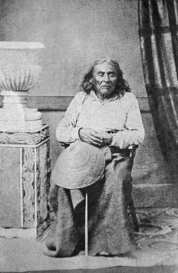
siʔaɫ, or Chief Seattle
The only known photograph of Chief Seattle (1786?–1866), taken by E.M. Sammis in 1864
Sign at corner of SW Seattle Street and 46th Avenue SW, July 4, 2011
Sign at corner of SW Seattle Street and 46th Avenue SW, July 4, 2011. Photograph by Benjamin Lukoff. Copyright © 2011 Benjamin Lukoff. All rights reserved.

So, why SW Seattle Street instead of Seattle Street SW?

In Seattle, east–west streets have the directional come first, and north–south avenues have it come last. The Wikipedia article “Street layout of Seattle,” which I helped write, has a more comprehensive description of Seattle’s addressing system, including the answer to this question:

Why was it W Seattle Street in 1907 but SW Seattle Street now?

In 1961, city ordinance 89910 “established a standard system of street name designations” so that in almost all cases streets within a given zone would carry the same directional. West Seattle avenues already carried the SW designation.